 |
|
Canadian Historic Sites: Occasional Papers in Archaeology and History No. 20
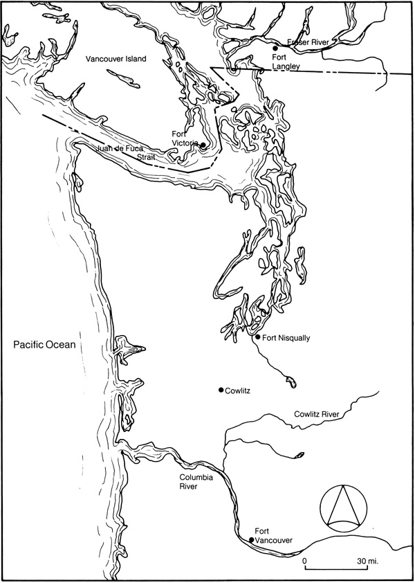
by Mary K. Cullen Establishing Inland CommunicationAfter the 1828 extension of British and American joint occupancy of Oregon, the Hudson's Bay Company continued to use the Columbia-Okanagan interior supply route from Fort Vancouver. Coastal shipping and other needs had attracted Simpson and the governor and committee to the idea of relocating Company headquarters during the 1830s. Yet the absence of a more effective inland communication, and McLoughlin's argument that therefore the post would have to be retained as an interior depot anyway, helped to keep Fort Vancouver in its dominant position. In the early 1840s, however, powerful political factors were added to traditional arguments for change with the result that Company headquarters were moved north. The process began in 1843-44 with the building of Fort Victoria and the reorganization of Company management, and was completed in 1849 with the transfer of the board of management to Fort Victoria and the successful establishment of a practical brigade route from Fort Langley into the interior. As early as 1841 Simpson practically abandoned his former hope that the Columbia River would become the boundary line. Following a personal visit to the Pacific in 1841, he wrote to the governor and committee in March 1842 that the coastal boundary would probably be drawn at Juan de Fuca Strait because "the Government of the United States will insist on having a post on the North West Coast, and that Gt. Britain will, for the sake of peace, accept the straits of de Fuca as a boundary on the Coast." The prospect of this boundary and the presence of a sizeable American population in the Willamette valley raised the question of the safety of storing all Company property at Fort Vancouver. By McLoughlin's own suggestion, the search for a suitable depot site had been directed to the south end of Vancouver Island in 1838. Simpson favoured the location for reasons of efficiency in shipping and he now added political pressures to his decision to transfer some of the functions of Fort Vancouver to a more northerly location.1 On 28 June 1842 the council of the Northern Department, assembled at Norway House, resolved that: it being considered in many points of view expedient to form a depot at the Southern end of Vancouver's Island, ... an eligible site for such a Depot be selected, and that measures be adopted for forming this Establishment with the least possible delay.2 A year later Douglas built Fort Victoria on a scale large enough to serve as general depot for the Pacific trade.3 The Company decision to reorganize its management of the Pacific fur trade was the result of a combination of factors. Relations between Simpson and McLoughlin had been strained since their disagreement over the conduct of the coastal trade and during Simpson's 1841 visit to the coast a serious feud developed between the two concerning the murder of McLoughlin's son at Fort Stikine. After this event the governor and committee found that McLoughlin's dispatches were filled with heated discussions of his son's murder and failed to give adequate accounts of his district. They were disturbed by the decline in revenue west of the Rockies and critical of McLoughlin's handling of several specific matters such as the Puget's Sound Agricultural Company and extension of credit to American settlers. Reorganization would facilitate the removal of McLoughlin and anticipate the political division suggested by Simpson. On 30 November 1844 the governor and committee informed McLoughlin that his general superintendency would cease on 31 May 1845 and that the Columbia department would be governed by a board of management of three members and would eventually be divided into two or more districts. During outfit 1845 the board consisted of Douglas, Ogden and McLoughlin, but in 1846 McLoughlin went on furlough and after two more years leave of absence, formally retired from the service on 1 June 1849.4 Although the official division of the Columbia Department into the Oregon and Western districts was not made until 18535 and Fort Victoria did not become headquarters until 1849, the Company retreat from the Columbia began in 1844. Scarcely had Fort Victoria been established when events in the Columbia River valley accented its importance. About 875 American immigrants arrived in the Willamette valley in the fall of 1843, reducing the British settlers to a relatively small minority group. Though a moderate provisional government favourable to everyone was initially formed, it was uncertain that the more radical American elements could be held in check. The possibility that the Company's land might be appropriated or its warehouses looted impressed the governor and committee, who in the autumn of 1844 ordered the annual supply ship Vancouver to proceed directly to Fort Victoria instead of the Columbia. The same year McLoughlin persuaded the Pacific naval commander to lend support to the British presence by sending HMS Modeste to visit the Columbia River. By 1845 "Oregon Fever," manifested in a continuing tide of American immigration and the cry, "Fifty-four forty, or fight!," brought Great Britain and the United States to the brink of war. Lieutenants Henry J. Warre and Mervin Vavasour, RE, were sent on a secret mission in the summer of 1845 to assess British defense of western North America, but before they completed their task, the two countries had reached a resolution.6 By the Treaty of Washington signed in June 1846, the 49th parallel became the boundary between British and United States territory west of the Rockies. Article 2 left navigation of the Columbia south of the 49th parallel "free and open to the Hudson's Bay Company and to all British subjects trading with the same" and stipulated that in the exercise of that right they should "be treated on the same footing as citizens of the United States." In practice, however, this guarantee of free and open navigation proved illusory and Company goods landed at Fort Vancouver for the interior were subject to import and transit duties levied by the United States government.7 The building of Fort Victoria anticipated the disadvantage of having the Company's principal depot in American territory, but the problem of an all-British communication with the interior was still unsolved. Early in 1845 the old idea of Fort Langley as a potential depot for the interior brigades was revived and in the process of intensive exploration and experimentation which resulted in a viable route from the Fraser River to the interior posts, Fort Langley played an active and guiding role. Almost a year before the conclusion of the treaty, Simpson wrote to Yale that in view of the unsettled state of the Columbia, the council was considering the necessity of finding an alternative route for the conveyance of the outfits and returns to and from New Caledonia. The governor asked Yale to communicate any information he might have on a route from the Fraser and to institute inquiries among the natives on the practicability of such a route.8 Yale discussed the matter fully with Douglas in December 1845 and also reported to Simpson that there was a practicable route "interiorly from the falls on the south side of the river, by a succession of vallies, small plains, and lakes, and with only one or two intervening mountains of no considerable height." He proposed to interview an Indian chief in that quarter to acquire additional information on the subject.9
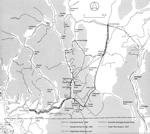
Alexander C. Anderson, chief trader in charge of Fort Alexandria who at this time was also in communication with Simpson on the subject, volunteered to explore a route to Fort Langley from the interior.10 The governor accepted Anderson's service and appointed him to explore two routes in the spring of 1846. Starting from Fort Kamloops on the Thompson River in May, Anderson followed a route north of the Fraser by way of a chain of lakes (the Anderson-Seton lake system) from the Lillooet River to the Harrison which he navigated to its confluence with the Fraser, taking the Fraser to Fort Langley. A succession of rapids for nearly 50 miles made the Lillooet exceedingly dangerous and in seasons of high water impossible for boats.11 On the recommendation of Anderson the board of management concluded that the route "will not answer our purpose and ought never to be attempted."12 On his return journey to Kamloops from Fort Langley in June 1846, Anderson explored a route by the south side of the Fraser. He ascended the Fraser 66 miles by water and thence commenced the land journey at the entrance of Silverhope Creek. When it became apparent that the river ran in a southerly direction, Anderson retraced his steps and determined to follow the Coquihalla, a tributary of the Fraser three miles higher. From the Coquihalla he marched along the valley of the Nicolum over a small height of land to the Sumallo River, eventually diverging northward along Snass Creek in a gentle ascent to the highest point of the mountain pass. Descending on the opposite or northern declivity of the mountain, his party had to contend with eight to ten feet of snow, which fortunately was compact enough to support them. A two-day march from one of the tributaries of the Similkameen brought them into open country and a camp near Otter Lake where their horses were waiting and carried them in a two-day ride to the Thompson, the original starting point. The return journey of 237 miles took 11 days. Anderson's only objection to the route was the depth and duration of the snow in the mountains which made the route impassable in early summer, but he suggested that if the brigades were delayed until the middle of July, the route should prove a practical communication.13 Although the board of management were at first favourably disposed to the Coquihalla road, they reserved judgement when Yale informed them that he had heard of another route which, by following the banks of the Fraser, avoided the mountains and would therefore be passable at all seasons.14 They requested Anderson to examine this route in May 1847 and to report to Yale on its eligibility.15 "The main point to be born in mind," they wrote to Yale, "is the accessibility of the route at all seasons as a communication rendered impassable by snow or water for 6 or 7 months in the year, would be of little value to us." The latter was "an almost insuperable objection to the [Coquihalla] road" and induced the board to give preference to a road which avoided the mountains altogether. They were anxious to establish a commercial communication with the interior as soon as possible and while making clear their own preference for the third route, if feasible, they left final determination of the matter with Yale and Anderson. Once the matter had been fully discussed at Fort Langley in the early summer of 1847, Yale was to "proceed in opening the new road with all the force at his command."16 The report Anderson made of his 1847 journey out to Fort Langley did not convince Yale that the Fraser valley route was a usable commercial highway. The party left Kamloops on 19 March and proceeded from there down the Nicola River to the "Little Forks" near Spences Bridge and southwest on a rough pathway along the Thompson, Fraser and Anderson rivers to Kequeloose about six miles from Spuzzum at the head of the Fraser canyon. The Indian guide Pashallak recommended that near this point horses could be ferried across the Fraser to a trail which led to the base of the canyon. Anderson felt the banks and strength of water precluded a large-scale horse ferry and, determining to test the navigability of the river, successfully canoed to Fort Langley. Though the river was then in freshet, Anderson concluded that by portaging at two or three places the route could be utilized for the conveyance of goods and furs.17 Yale, who had been involved with Simpson in his 1828 explorations of the Fraser River, was unconvinced of the placid quality of the Fraser canyon and had intended that Anderson explore a section of the riverbank to avoid the difficult part of the Fraser. He was coming to the conclusion that the route by the Similkameen valley which Anderson had followed the previous spring would probably be more feasible, but Anderson felt otherwise and on 1 June left Fort Langley returning inland by the Fraser to Kequeloose and then overland in a northwest direction to Kamloops.18 Anderson endorsed the river route to the board of management, reporting that the rapids, "in all from 2 to 3 miles," presented "no insurmountable impediment."19 In July Yale had a party re-explore the 1846 trail and reported that the snow on the mountain ridge was "of insufficient magnitude to impede the progress of horses."20
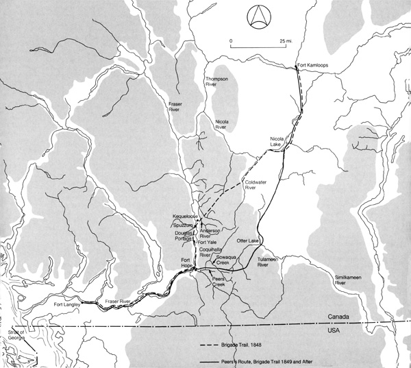
All of Douglas's hopes sided with the Fraser River route, which he considered would provide year-round access to the ocean, but in view of Yale's hesitation he refrained from giving an opinion on the route "until the 'Falls' have been further examined by good watermen, and reported practicable; and until we are satisfied that all imminent risk can be avoided by means of portages or otherwise."21 In September 1847 Douglas personally retraced Anderson's explorations with Yale and William Sinclair, spending several days in examining the chain of rapids known as "the falls." "Before he reached the head of the falls," Yale wrote privately to Simpson, "he was convinced that Fraser's River was not quite that placid stream he before seemed to imagine."22 Contrary to Anderson's picture of two or three miles of rapids with a few intervening smooth places, rapids extended from the Saumeena to the upper Teat Village, a distance of 13 miles. Douglas declared "it is impossible to conceive anything more formidable or imposing than is to be found in that dangerous defile which cannot for one moment be thought of as a practicable water communication for the transport of valuable property." He concluded, however, that Pashallak's suggestion of crossing the river at Spuzzum was practicable and that horses could proceed about 13 miles on the north side of the Fraser to the lower end of the rapids through the narrow winding defile, soon known as Douglas Portage. From the finish of the road at the lower end of the rapids to Fort Langley, approximately 130 miles, transport could be effected by boats.23 During their exploration of the Fraser, Douglas and Yale received Indian advice of another route to the south of the Fraser which met the river about 25 miles above Fort Langley. Potentially this route seemed superior to both the Coquihalla road and the Fraser River route for its southern position avoided the elevation of the mountain and its proximity to Fort Langley eliminated the expense of maintaining a fleet of boats exclusively for river transport. A decision on a new commercial highway would have to be made soon for already the Company had learned that its right of "free navigation" of the Columbia was not enforceable and that goods for New Caledonia which arrived at Fort Vancouver were subject to duty. Yet the greater efficiency which the latest route promised recommended its exploration before a final decision was taken. Aiming for 1849 as the first year for using the new brigade trail, the board ordered Yale to have this last alternative examined, to come to a decision and then to start clearing one of the two in the spring of 1848.24 A party from Fort Langley commenced explorations on 26 October 1847, but their report indicated a scarcity of food for horses, an objection which Yale considered final.25 Early in November, therefore, Yale began making the necessary arrangements for opening the route by Douglas Portage. On 10 November his interpreter, Ovid Allard, and a party of six men were sent off to build a store at the crossing place above the rapids and a house and store at the foot.26 About three weeks after the Langley men had begun to build Fort Yale (as the place at the foot of the rapids was soon called), an incident south of the 49th parallel closed the Columbia River as a commercial highway. The murder of Dr. Whitman and 13 others at the mission station at Wai-i-lat-pu touched off the Cayuse Indian War of 1848 in Oregon and compelled the Company to adopt immediately the Fraser River route.27 From his letter to Simpson in December 1847, it appears that Yale was aware then that the route to Fort Langley would be used the next summer.28 In March 1848 the board wrote to Yale approving his move to establish the route by the Fraser River and informing him that the Thompson River, New Caledonia and Fort Colvile brigades could be expected at Langley the first week of June.29 (In 1825 Simpson had established Fort Colvile as the centre of the Flathead-Coutonais fur trade.) The plan of action as outlined by the board in their March 1848 letter forecast the responsibilities of Fort Langley as the key post in the new transport service. District outfits, with an assortment of goods and equipment for the officers and men, were immediately forwarded by the Brig Mary Dare.30 Even before the Columbia disturbances the Company had sent Samuel Robertson, a boatbuilder, to Fort Langley to build four large batteaux for future river transportation.31 Yale was now instructed to send three of these boats with a supply of provisions for 60 men to Fort Yale by 25 May. The Langley staff was responsible for bringing the men and their fur returns to the depot and transporting the interior outfits to the rapids for the return journey. At the fort Henry Newsham Peers, who accompanied the brigades from the Thompson, was to be placed in the equipment shop to make up the orders and supply the men. Packs of furs had to be opened and dusted, and marten and small furs repacked in empty fur puncheons for shipment to Fort Victoria.32 The magnitude of the work undertaken by Fort Langley as trail blazer and depot for the brigades was fully acknowledged by James Douglas and John Work in their letter to the governor and council dated 5 December 1848. The preparations for opening the new road to the interior for the passage of the summer Brigade threw much additional work upon the establishment of Fort Langley, as besides making the road from Kequeloose to the Ferry, and from thence through the Portage to the lower end of the Falls of Frasers River, a distance of 18 miles, through a wooded country, levelling and zig-zagging the steep ascents, bridging Rivers, there were stores erected for the accomodation of the Brigades above and below the Falls, boats and scows built for the ferry, and seven large Boats for the navigation from Fort Langley to the Falls, there was the heavy transport of provisions to the latter place and a vast amount of other work connected with that object which it required no common degree of energy and good management in Chief Trader Yale to accomplish with 20 men in the course of a severe winter.33
The annual Hudson's Bay Company brigades from the interior made their first journey by the new all-British route over the Fraser River trail in the summer of 1848. The three brigades from New Caledonia, Thompson River and Colvile, numbering 50 men and 400 horses, were dispatched in the command of Donald Manson and Anderson. A number of the pack horses were still wild and literally scrambled over the mountains to reach the Fraser River at Spuzzum. Getting the 400 horses and their lading across the freshet-swollen river was another strain and it was followed by an equally difficult journey through Douglas Portage. Meanwhile, the batteaux from Fort Langley struggled upstream for eight days against the heavy current, the men towing with lines and pushing with poles to make the rendezvous at Fort Yale. Only the last 130 miles downstream were easy, the current swiftly carrying men and baggage to Fort Langley. On the return trip inland the difficulties were greatly multiplied. The trade goods were bulky and more perishable than the furs. Large quantities of merchandise were stolen by the natives who gathered in the canyon for the annual fishing. Seventy horses were lost during the trip and by one account 16 and another 25 pieces of merchandise.34 Both Anderson and Manson heartily condemned the Fraser River route as a practical business communication with the interior. Although he had come to agree with the board of management on the unnavigability of the river above Fort Yale, Anderson was reluctant to endorse the Douglas Portage as a feasible route for horses. "The portage known as Mr. Douglas' I do not approve of," he informed Manson in August. "Pasture is scarce and there is a ravine in it which is too steep and rugged." Writing Douglas, he added: My recent experience of the pass in question convinces me that no portage on a large scale could with prudence be effected there during the summer months, after the hosts of barbarians amongst whom we have recently passed are engaged in their fisheries. Yet the greatest loss of property and horses occurred in the six-mile mountain tract between the traverse and Kequeloose. Here the horses stumbled and were maimed and the dislodged packs rolled down into the river from the precipices.35 Manson considered the road by Douglas Portage quite usable, but condemned as "utterly impracticable" the entire route from the Fraser to the plains: "From 45 to 50 miles ... a succession of very high mountains, rocky and rugged in the extreme, with deep and thickly wooded ravines dividing each range, and with the exception of one place, no grass to be found along the whole extent of the pass."36 Yale attributed many of the difficulties of the 1848 experience to bad management. The horses used on the way out for carriage in Douglas Portage were not taken across to the grazing ground or horse guard on the south side of the river, but left in the portage where there was little food for them. An extra 200 horses were brought from Kamloops to the Fraser a month too soon to share in the very scanty means the place afforded for the 100 there. Each man in the brigade had 15 to 20 horses to take care of and there were no spare men for a guard to hurry up the rear. When the last horse was saddled and loaded the day was over and though the distance was but 30 or 40 miles it was a wonder that they got through at all.37 In October 1848 Douglas went to Fort Langley to confer with Yale on alternate arrangements for communication with the interior. As early as July 1847, Langley's officer in charge had had Anderson's second 1846 route re-explored with the idea that it might be opened with some changes.38 When Manson reached Thompson River District after completing his disastrous inland journey of 1848 he had Henry Newsham Peers re-examine this route.39 The road which Peers recommended followed successively the valleys of the Coquihalla River and Peers and Sowaqua creeks, then crossed the dividing ridge into the Similkameen valley and fell in with Anderson's track of 1846, following it to the Thompson. His report was favourable enough as to ground, the ascent of the mountains being gradual on both sides, but he was informed by his Indian guide that the depth of snow made the mountains impassable with horses until the beginning of July.40 The same difficulty had prompted Douglas to reject Anderson's 1846 route in favour of the one tried via the rapids of the Fraser River. Douglas still looked on the latter as the least objectionable, but in view of the "extreme reluctance of Mr. Manson to continue the route of last summer" he determined to go to the expense of opening a new road "which in many respects will be found exceedingly inconvenient."41 Once again responsibility for making the projected interior route usable fell to Fort Langley. In a memo summarizing their discussions at Fort Langley in October 1848, Douglas instructed Yale to employ as many of his own men as could be spared from the duties of his establishment, with as many Indians as could be induced to assist, to work with Peers in clearing and levelling the new road. The party would select a convenient spot near the mouth of the Coquihalla and build an establishment surrounded with stockades consisting of a dwelling house and two stores to accommodate the brigades passing and repassing to the interior. When the interior outfits arrived at Fort Langley in the spring, Yale would forward them in whole or in part to the establishment at the Coquihalla, provided they might be left there without risk.42 After making these arrangements, Douglas later decided that the outcoming brigades must reuse the summer route of 1848 since it would be impudent to rely too confidently on the prospect of finding the new road finished and accessible for the passage of the Brigade in the spring of 1849, as the depth of snow, the swolen [sic] state of the rivers, the want of pasture and other causes may and most probably will disappoint our hopes.43 Besides preparing the new road south of the Fraser, Fort Langley sent boats and provisions to meet the brigades at the rapids on the Fraser and provided craft for crossing the property above the rapids.44 By the early summer of 1849 the Langley party had completed Fort Hope at the mouth of the Coquihalla and opened the new road to a point where further progress was impeded by snow. In May Peers and his men went on the old Fraser River road to repair it and to meet the brigades which were expected to be near.45 Douglas, who was at the interior depot to hurry the departure of the brigades, reported to Simpson that "the Brigade men behaved well at Fort Langley and started in good spirits in contrast to their behavior the preceding year."46 About six days' batteaux journey from Fort Langley the brigades reached Fort Hope where they commenced the trip inland by Peers's road. There were many difficulties, but according to Manson and Anderson the new route was "infinitely preferable" to the one by the Fraser River.47 The greatest impediment was the snow in the mountains which left uncertain the outward passage of the brigade in the spring. The snow had also prevented the road from being fully cleared, with the result that Manson and 20 of his men were employed for 15 days clearing the passage.48 The two-month round trip from Fort St. James to Langley, however, had caused a late return to Stuart Lake which was considered highly unfavourable for the distribution of the outfits.49 There was little doubt that Peers's road was more eligible than the long circuitous route to Fort Vancouver, but the time involved in the passage presented some difficulty in a Company timetable designed to get the inland goods distributed well before the winter. Manson left the impression that difficulties could be met by more work on the road,50 but it soon appeared that there was an other reason for the delay. Yale wrote to Simpson that when Peers and his party went to meet the brigades they were found lolling away the time at Kamloops, and to mind the matter the Langley party who were desired to resume their work on the new route after their return with the Brigade to Fort Hope, were brought down here, and thus did Mr. Manson subject himself to the sad necessity of disencumbering the track of some of its obstructions but which he might have got performed without any inconvenience some 15 or 20 days earlier.51 Simpson learned from other sources that Anderson and Manson were at odds with each other and that their failure to communicate had detained the New Caledonia brigade several weeks at Fort Kamloops awaiting the arrival of Anderson with the Colvile returns.52 Douglas reported that on their return journey they came to high words at Fort Hope and parted in anger.53 The successful outward trial of Peers's road by the brigades in 1850 finally established the all-British route to the interior. The brigades crossed the Fraser River ridge without difficulty, the snow being compact enough to support the loaded horses. The men met with no molestation from the natives and in general reported favourably on the road. The Colvile people reached Langley in 17 days' moderate travelling, and the other brigades took ten days from the Thompson.54 On 17 August 1850 a rejoicing Douglas wrote to A. Barclay in London; It is a great relief to have established the practicability of this route to the interior through the formidable barrier of mountains which separates it from Frasers River — while it will have the effect of imparting a greater degree of confidence of our own operations, it may also have an important bearing on the future destinies of the country at large; a triumph, probably the last of the kind reserved for the Fur Trade.55 For the officer in charge of Fort Langley who had laboured to open communication at a time when the salmon fishery was increasingly important, the final establishment of the brigade trail also brought relief. Yale felt that henceforth the brigades themselves should assume responsibility for maintaining the route and he confided to Simpson his hope that "the interesting matter will now be permitted to rest with themselves, as more consistent with their means, than that which can be afforded from Langley, and without due consideration might continue to be required annually forever."56 While Fort Langley's exploratory work was complete, however, its position as interior depot involved a host of arduous duties which it undertook for another decade. |
||||||||||
|
||||||||