|
Park Summaries
Yukon
All text and photos are copyrighted by Parks Canada or the Canadian Register of Historic Places
(except as noted) and were extracted from either the Parks
Canada or Canada's Historic Places
Websites. Parks with a grey background are managed by Parks Canada.

©Parks Canada Agency / Agence Parcs Canada, 1985 |
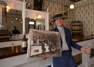
Canadian Bank of Commerce National Historic Site of Canada
Dawson, Yukon
The Canadian Bank of Commerce National Historic Site of Canada is
located on the riverfront in Dawson City, Yukon. It is a handsomely
designed, two-storey wood structure of native spruce with ornamental
pressed metal fronts sanded and painted to resemble grey sandstone.
Despite its small size and modest construction materials, the building
is an ambitious essay in classical architecture, featuring a cornice,
pilasters, elaborate mouldings and artificial rustication, all executed
in pressed metal.
The heritage value of Dawson City's Canadian Bank of Commerce lies in
its longstanding role in Yukon history, in the excellence and
sophistication of its design and composition, particularly in a northern
environment, and in its prominent location in the historic Gold Rush
town of Dawson. Originally housed in a tent, the Canadian Bank of
Commerce relocated several times before finally settling in the current
building designed and built by W.P. Skillings and Robert Moncrief in
1901. Its grand architectural style reflects the important services that
were performed by the bank, such as the buying and melting of gold into
bricks and the brokering of gold on world markets. This structure, with
its sophisticated form, was a prominent and visible symbol of the bank's
significance within the community. It operated as a bank until
1989.
|
©Parks Canada Agency / Agence Parcs Canada |
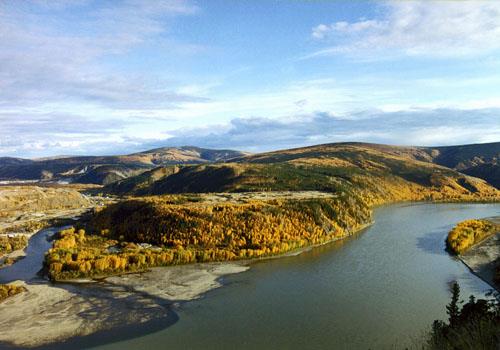
Dawson Historical Complex National Historic Site of Canada
Important collection of buildings from the Klondike Gold Rush
Dawson, Yukon
The Klondike National Historic Sites of Canada commemorate the 1896
Klondike Gold Rush, the role of large corporation gold mining in the
Klondike and river transportation in the Yukon. Dawson City,
conveniently located at the junction of the Yukon and Klondike Rivers,
quickly became the heart of the gold fields during this time.
The Dawson Historical complex comprises the core of Dawson City, Yukon,
a town established during the Klondike Gold Rush on a flat of land at
the confluence of the Yukon and Klondike Rivers in a vast, rugged,
northern landscape. Most buildings reflect pioneer, boom-town
architecture in their small scale, simple massing and wood construction.
Dawson Historical Complex was designated a national historic site of
Canada for its association with the full extent (1896-1910) and impact
of the Klondike Gold Rush.
The heritage value of Dawson Historic Complex National Historic Site of
Canada is embodied in its evocation of the time and place of the
Klondike Gold Rush, which is conveyed by the surviving natural and built
landscape features. Of particular value are the outlines of the original
townsite survey, and the wide range and occasional concentration of
frontier structures, which confirm the town's early nature, diversity,
northern isolation, and links to mining activity during the 1896-1910
period. Since the 1960s, Parks Canada has conserved and presented many
of the buildings in the town, laying the foundation for its
re-incarnation as a tourism venue.
Buildings included in the Complex:
- Bank of British North America/Bank of Montréal
- Billy Bigg's Blacksmith Shop
- Canadian Bank of Commerce
- Carnegie Library/Masonic Temple
- Commissioner's Residence
- Daily News Building
- Dawson Post Office
- Former Territorial Court House (see below)
- Klondike Thawing Machine Company
- Northwest Mounted Police Married Quarters
- Palace Grand Theatre
- Robert Service Cabin
- St. Paul's Church (see below)
- Yukon Hotel (see below)
|

©Parks Canada Agency / Agence Parcs Canada, John Gould, 1998. |
Discovery Claim (Claim 37903) National Historic Site of Canada
Bonanza Creek, Yukon
Discovery Claim National Historic Site of Canada is the
place where the Klondike gold rush began. It is a legally defined mining
claim measuring some 152.4 (500 ft.) by 609.6 metres (2000 ft.) located
on Bonanza Creek, a tributary of the Klondike River near the town of
Dawson, Yukon Territory. The site is in a deep valley which has been
dredged both by hand and with mechanized equipment, leaving deposits of
dredge tailings and scarred hillsides below the heavily treed upper
slopes.
|
©Parks Canada Agency / Agence Parcs Canada, JF Bergeron, 2000 |
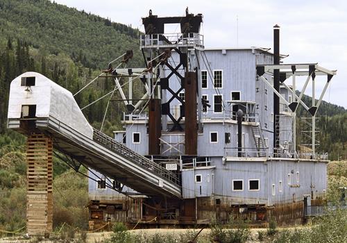
Dredge No. 4 National Historic Site of Canada
Symbolizes importance of dredging operations (1899-1966) with the evolution of gold mining in the Klondike
Bonanza Creek, Yukon
Not long after gold was discovered in large quantities in the Klondike,
dredges were brought into the Yukon, the first dredge being built in the
fall of 1899. One of the two dozen dredges that worked this area, Dredge
No. 4 rests on Claim No. 17 Below Discovery on Bonanza Creek near the
spot where it ceased operations in 1960. The largest wooden hull,
bucket-line dredge in North America, it was designed by the Marion Steam
Shovel Company.
Dredge No. 4 is a preserved bucketline sluice dredge used to mine placer
gold. Located at its last place of operation on Bonanza Creek in the
Klondike goldfields just outside of Dawson City, Yukon, it is now
preserved and operated as a historic site.
Dredge No. 4 was constructed in 1912-13 by the Canadian Klondike Mining
Co. to mine the gravels of the Klondike River Valley. It was dismantled
when paying gravels ran out in 1940. All of its major mechanical
components were refurbished by the Yukon Consolidated Gold Corporation
and encased in a new wooden hull and superstructure built on Bonanza
Creek. From September 1941 to the fall of 1958 it mined Bonanza Creek.
There, it sank on its present site in 1959. It has since been preserved
as a National Historic Site.
The heritage value of Dredge No. 4 lies in its association with Klondike
gold mining and in its illustration of the process of bucketline sluice
dredging used by corporations to mine placer gold in the Klondike Gold
Fields in the 1899-1966 period.
|

©Parks Canada Agency / Agence Parcs Canada, W. Lynch, 1995 |
Former Territorial Court House National Historic Site of Canada
Substantial frame judicial building, 1900-01
Dawson, Yukon
The Former Territorial Court House National Historic Site of Canada is a
handsome, two-storey wood-frame building designed in a classical style,
on a prominent setting within the Dawson Historical Complex National
Historic Site of Canada in Dawson, Yukon Territory. The building is
distinguished by its imposing scale, regularly arranged two-over-two
sash windows, and its metal hipped roof topped with a lantern. The
building is now maintained by Parks Canada and serves as an important
landmark on the streetscape.
Its heritage value resides in it identity as a symbol of the Canadian
legal system as illustrated by its formal and functional design.
Purpose built to replace the original, inadequately sized log
courthouse, the Former Territorial Court House was designed with two
court chambers in order to accommodate the large volume of court
business. The building of such an impressive structure in the remote
location of Dawson was a clear physical statement of the Canadian
government's determination to establish and maintain a stable
environment for the Dawson community. Designed by Department of Public
Works architect, Thomas Fuller, the former court house was built from
1900 to 1901. When the court was relocated in 1910, the building was
taken over by the North West Mounted Police who re-allocated interior
spaces for their own uses. In 1954, the Sisters of St Anne took it over
for use as a hospital. They carried out further interior alterations and
added a new wing, but maintained the integrity of the original exterior
elevations. Today, the building is maintained by Parks Canada as part of
the Dawson Historical Complex National Historic Site of Canada.
|
©Parks Canada Agency / Agence Parcs Canada |
Ivvavik National Park of Canada
Headquarters: Inuvik, Yukon
Calving ground for the Porcupine caribou herd.
Ivvavik, meaning 'a place for giving birth, a nursery', in Inuvialuktun,
the language of the Inuvialuit, is the first national park in Canada to
be created as a result of an aboriginal land claim agreement. The park
protects a portion of the calving grounds of the Porcupine caribou herd
and represents the Northern Yukon and Mackenzie Delta natural
regions.
|
©Parks Canada Agency / Agence Parcs Canada, 2012 |
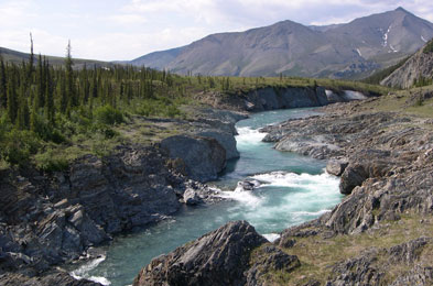
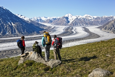
Kluane National Park and Reserve of Canada
Headquarters: Haines Junction, Yukon
Yukon's UNESCO World Heritage Site contains Canada's highest peak.
Kluane National Park and Reserve of Canada covers an area of 21,980
km2. It is a land of precipitous, high mountains, immense
icefields and lush valleys that yield a diverse array of plant and
wildlife species and provides for a host of outdoor activities. Kluane
National Park and Reserve is also home to Mount Logan (5959 m/19,545
ft), Canada's highest peak.
As part of a larger system of national parks and historic sites found
throughout Canada, Kluane National Park and Reserve protects and
presents a nationally significant example of Canada's North Coast
Mountains natural region and the associated regional cultural heritage.
Fostering public understanding, appreciation and enjoyment of Kluane
National Park and Reserve while ensuring ecological and commemorative
integrity for present and future generations is Parks Canada's
goal.
|

©Parks Canada Agency / Agence Parcs Canada, 2000 |
Old Territorial Administration Building National Historic Site of Canada
Dawson, Yukon
The Old Territorial Administration Building National Historic Site of
Canada is located in Dawson, in the Yukon Territory. The two-and-a-half
storey building, set on landscaped grounds, is the largest of the
buildings in the Dawson Historical Complex National Historic Site of
Canada dating from the late 19th and early 20th-century Klondike Gold
Rush. Constructed in the neoclassical style, the building features an
impressive front façade organized around a raised, pedimented entrance
flanked by double ionic columns.
The heritage value of the Old Territorial Administration Building lies
in its associations with the Klondike Gold Rush of 1896, and the
subsequent growth of the northern territories and the rest of Canada.
The imposing architectural design of the building in the remote location
of Dawson was a clear physical statement of the Canadian government's
determination to fulfill its administrative role, while asserting
sovereignty of the territory contiguous with the American state of
Alaska.
Designed by the Department of Public Works architect Thomas W. Fuller in
1899, the building was constructed in 1901 as the legislative and
administrative headquarters of the new Yukon Territory. As Dawson's
population declined with the end of the gold rush, the government
centralized its territorial and federal services into the Administration
Building. It became the sole government building still active, and
remained the centre of the federal and territorial government in the
Yukon until 1953, when the capital was moved to Whitehorse.
|
©Parks Canada Agency / Agence Parcs Canada, P. McCloskey, 1977 |
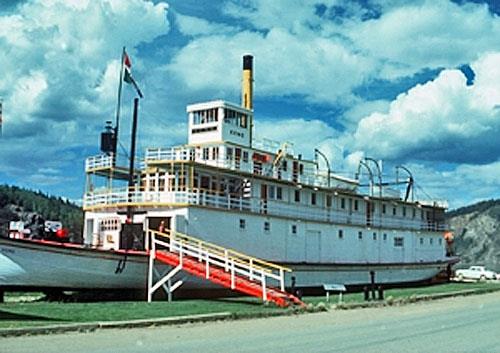
S.S. Keno National Historic Site of Canada
Wooden steamboat built 1922, 140 feet x 30 feet, three decks, dry docked in Dawson home of the Klondike
Dawson, Yukon
S.S. Keno National Historic Site of Canada is a steam powered
sternwheeler river vessel which rests on the bank of the Yukon River
beside Front Street in Dawson, Yukon Territory.
The S.S. Keno was designated a national historic site of Canada because
it is representative of Yukon lake and river sternwheeler steamers.
The heritage value of the S.S. Keno resides in its completeness and
legibility as a fast water shallow drafter sternwheeler steamer
representative of the type of vessel built for Yukon water
transportation. The S.S. Keno was built in Whitehorse in 1922 to move
ore from Mayo Landing on the Stewart River to Stewart Island on the
Yukon River. In 1937 it was cut in half to permit three meters to be
added to its length, increasing its freight capacity. She was retired at
the close of river navigation in 1953, re-furbished in 1960 and sailed
downriver to Dawson where it is managed as a historic site open to the
public.
|
©Parks Canada Agency / Agence Parcs Canada |
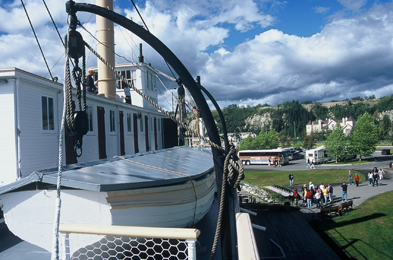
S.S. Klondike National Historic Site of Canada
Largest and last Yukon commercial steamboat
Whitehorse, Yukon
The British Yukon Navigation (BYN) Company sternwheel fleet plied the
upper Yukon River between Whitehorse and Dawson City for the first half
of the Twentieth Century. The S.S. Klondike was the largest of the BYN
fleet. Originally built in 1929, she sank in 1936, was rebuilt and
launched in the spring of 1937. Located on the banks of the Yukon River
in Whitehorse, Yukon and restored to her original 1937-40 appearance,
the S.S. Klondike pays tribute to an era of riverboat transportation and
the inland water transportation system that linked the Yukon to the
outside world before the advent of roads.
|

©Parks Canada Agency / Agence Parcs Canada |
St. Paul's Anglican Church National Historic Site of Canada
Dawson, Yukon
St. Paul's Anglican Church National Historic Site of Canada, located on
the banks of the Yukon River, is a component of the Dawson Historical
Complex National Historic Site of Canada, Yukon. This example of
frontier mission architecture was built in 1902 in the Gothic Revival
style, its simple volumes set under a steeply pitched roof. The
rectangular building has a central tower attached to the west end,
truncated transepts and a semi-circular apse. Regularly placed, pointed
arch side windows light the nave, while rose windows are set high in the
transept terminals. Modest ornamentation includes the dark-painted
accent boards and "half timbering" boards on the upper section of the
tower.
Constructed in 1902 to serve the new settlement at Dawson, this small
church is a significant example of frontier mission architecture. Its
simple design blends Gothic Revival style elements, including stained
glass windows and well-crafted woodwork, with an Arts and Crafts
aesthetic. Other features include exposed roof trusses made of heavy
timbers and transept-like side wings, which serve as a vestry, organ
alcove, meeting and choir rooms. St. Paul's, which took the place of an
earlier log building, is also a symbol of the long-standing presence of
Anglican missions in Canada's North beginning here in the 1860s,
ministering to Aboriginal peoples and later to miners and
settlers.
|

©Parks Canada Agency / Agence Parcs Canada, David Neufeld |
T'äw Tà'är National Historic Site of Canada
Teslin River, Yukon
Located at the intersection of many regional travel routes, it is an
Aboriginal cultural landscape that represents the interconnected web of
seasonal food gathering activities, family relations, travel and trade
of the Southern Tutchone people of Ta'an Kwäch'än.
The trails and waterways that lead out from T'äw Tà'är illustrate the
sustained relationship between the Ta'an Kwäch'än and their traditional
territory, through which the Ta'an Kwäch'än travelled each year to
harvest animals, plants and fish;
The travel routes that met at T'äw Tà'är fostered a network of marriages
and resulting family lineages, as well as cooperation, travel, and the
maintenance of good relations with neighbours such as the Northern
Tutchone, Tagish, Tlingit and Kaska peoples, culturally connecting the
southern Yukon Athapaskan peoples to each other.
|
©Parks Canada Agency / Agence Parcs Canada, 2000 |
Tr'ochëk National Historic Site of Canada
Dawson, Yukon
Tr'ochëk National Historic Site of Canada lies on an upstream flat at
the confluence of the Yukon and Klondike Rivers, just south of Dawson
City, Yukon. The Klondike River breaches the high hills along the east
bank of the Yukon, just skirting the base of a steep hill that rises to
form a high, flat bench. The river flat features a large, open grassy
meadow that contains the remains of Hän fish camps, traditional plant
harvesting areas and bench lookout points that offer views of
traditional Tr'ondëk Hëwch'in First Nation land.
Tr'ochëk is representative of the Tr'ondëk Hëwch'in 'home' in the middle
Yukon River. It contains late prehistoric and protohistoric
archaeological resources that attest to the profound influence of the
Yukon River on traditional Hän culture, oral histories, language, and
place names. For countless generations, the Hän spent the mid-summer to
late fall at fishing camps at Tr'ochëk, where they harvested and dried
fish, cleaned skins from moose and caribou and prepared other foods for
winter storage. The Hän made seasonal use of this site, named Tr'ochëk
to signify "the place at the mouth of the river," until the arrival of
thousands of gold seekers during the Klondike Gold Rush of the late 19th
century disrupted their traditional patterns.
The Hän people derive practical value from the river, which they use as
a transportation route, a source of food, and spiritual value through
the associations, stories and symbolic connections that the people have
made to it. This cultural landscape also consists of trails and lookout
points linked to the oral histories and traditional hunting, fishing and
gathering practices of many generations of Hän people.
|
©Parks Canada Agency / Agence Parcs Canada |
Vuntut National Park of Canada
Headquarters: Old Crow, Yukon
Northern Yukon's unique non-glaciated landscape.
Vuntut National Park was established in 1995 as part of the Vuntut
Gwitchin First Nation Final Land Claim Agreement. Vuntut, which means
"among the lakes" in the Gwitchin language, encompasses 4,345. sq. km of
wilderness in the northwestern corner of the Yukon Territory. The park
is bounded by the height of land and Ivvavik National Park to the north,
the international boundary and the Arctic National Wildlife Refuge to
the west, Black Fox Creek to its confluence with the Old Crow River to
the east and the Old Crow River to the south.
|
©Heritage Canada / Patrimoine Canada |
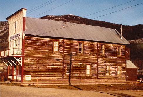
Yukon Hotel National Historic Site of Canada
Dawson, Yukon
A small wooden false-front building on First Avenue, "Dawson City's"
major street at the height of the Klondike Gold Rush.
The heritage value of the Yukon Hotel resides in its representation of
typical commercial structures built at the height of the Klondike Gold
Rush as illustrated by its site, setting and composition. Built in 1898
by J. E. Binet, the Yukon Hotel was first known as the Binet Block.
Initially rented for Government Offices, it became a hotel in 1900 and
served as such under a variety of names until 1957. Today it has been
restored as part of Dawson Historical Complex National Historic Site of
Canada.
|
|