|
Park Summaries
Nova Scotia
All text and photos are copyrighted by Parks Canada or the Canadian Register of Historic Places
(except as noted) and were extracted from either the Parks
Canada or Canada's Historic Places
Websites. Parks with a grey background are managed by Parks Canada.
©Parks Canada Agency / Agence Parcs Canada |
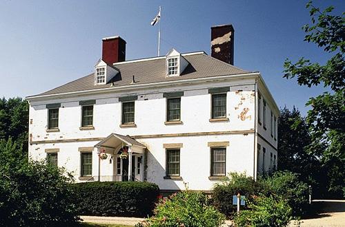
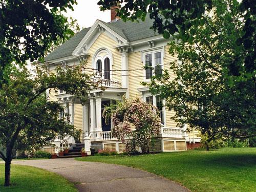
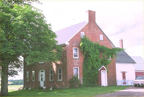
Acacia Grove / Prescott House National Historic Site of Canada
Starr's Point, Nova Scotia
Acacia Grove / Prescott House National Historic Site of Canada is an
extensive property in the Annapolis Valley, Nova Scotia. Set amidst
gardens and orchards this large, Georgian House from the early
19th-century has a rectangular footprint, regular openings on its
façade, a hipped roof flanked by two chimneys, and a small pediment over
the front door. The substantial two-and-half-storey brick home is an
outstanding example of domestic architecture inspired by the British
classical tradition.
Acacia Grove, a dignified brick house, follows the formal architectural
conventions of the Georgian style (British Classical style) and combines
the compact form derived from British classical tradition with Palladian
ornamentation. Its successful, symmetrical design and balanced
proportions are embellished with restrained classical detailing. When
Charles Ramage Prescott retired from business in Halifax, he relocated
to his rural estate in the Annapolis Valley where he had built a fine
home of British classical inspiration set in the midst of outbuildings,
extensive gardens, and orchards. He is best remembered for introducing
improved varieties of apples to the area and for establishing the New
Brunswick Fruit Growers Association. The property came to be known as
Acacia Grove for the grove of Acacia, or Black Locust trees planted by
Prescott. Over the years, the property passed through a number of owners
until it eventually fell into disrepair. It was restored by Prescott's
great-granddaughter in the 1930s and is now administered as a house
museum by the Nova Scotia Museum.
|
©Parks Canada Agency / Agence Parcs Canada |
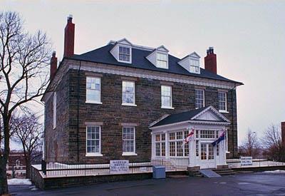
Admiralty House National Historic Site of Canada
Halifax, Nova Scotia
Admiralty House National Historic Site of Canada is a dignified
two-storey stone mansion set within the precincts of the Stadacona site
of Canadian Forces Base Halifax. Its austere stone construction material
and restrained neo-classical design speaks to its British origins. Once
the home of Commander-in-Chief of the Royal Navy's North American
station, it now houses Canada's Maritime Command Museum.
The heritage value of this site resides in its historical associations
with the Royal Navy and those physical and design elements that speak to
it British classical style. Built 1815 to 1819, to house the British
naval Commander-in-chief for the North American station, this house was
acquired by the Canadian government in 1904 for the use of its military
forces in Halifax. It has served a variety of functions since that time.
Damaged during the Halifax Explosion of 1917, it was repaired and for
many years was used as an officers' mess and offices. It is now the home
of the Maritime Command Museum.
|

©Public Archives of Nova Scotia/ Archives publiques de la Nouvelle-Écosse, Bob Brooks Collection/ Collection Bob Brooks |
Africville National Historic Site of Canada
Halifax, Nova Scotia
Africville National Historic Site of Canada is a site of remembrance for
Halifax's African Canadian community. Once the location of a historic
Black community, the houses were demolished in the 1960s and the land
converted into municipally owned Seaview Park. Located at the north end
of Barrington Street on Bedford Basin, below the A. Murray MacKay
Bridge, Africville is a symbol of African Canadian community
organization and a site of pilgrimage for people honouring the struggle
against racism. The open landscape is marked by a sundial-shaped
monument commemorating the former community.
Africville was initially settled by African Canadians seeking employment
in Halifax during in the 1830s and 1840s. The community grew during the
19th century with its own school and church, the Seaview African United
Baptist Church. Over the years, the City of Halifax consistently denied
the community municipal services and, during the urban renewal movement
of the 1960s, undertook the clearance of the area. Despite protests, the
community was dismantled and its members were relocated elsewhere in the
city. A campaign for redress eventually emerged and Africville took on a
symbolic identity, one which has persisted as representative of the need
for pride and vigilant defense of Black institutions and traditions. As
such it has served as a source of inspiration to other African Canadian
communities and nurtured leaders of its own, including members of the
Carvery family and the well-known defender of human rights, Burnley
''Rocky'' Jones. The city has developed the land into the Seaview
municipal park which has become an annual place of pilgrimage for the
Africville Genealogical Society, an organization of former residents and
their descendents.
|
©Parks Canada Agency / Agence Parcs Canada |
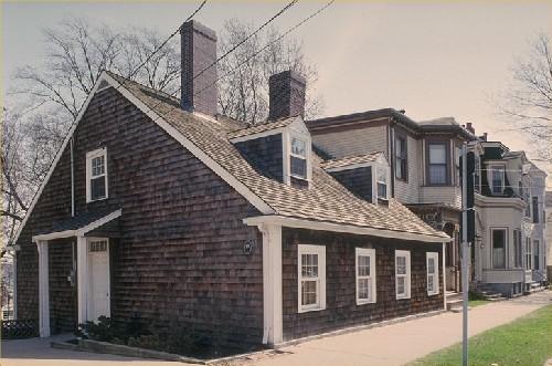
Akins House National Historic Site of Canada
Halifax, Nova Scotia
Akins House National Historic Site of Canada is a small house on an
urban lot in downtown Halifax, Nova Scotia. The one-and-a-half-storey
wood-shingled house, built circa 1815, resembles Cape Cod-style houses
of the Atlantic region. Along with its split wood-shingles, the house
also features a low, four-bay façade with two dormers above and two tall
brick chimneys. Akins House is one of the few remaining early
19th-century houses in Halifax and one of the oldest houses in the
city.
The heritage value of this site resides in its associations with Thomas
Beamish Akins, and in the physical elements dating from the late 18th to
early 19th century.
Akins House is notable for its longevity and retention of original
features. The house is representative of the period of its construction,
as evidenced by both its interior and exterior features, many of which
date from the time of construction and are notable for their details,
including trim and carvings that were more likely to be found in larger
houses of the period. With its wood shingled exterior, dormer windows
and square floor plan, Akins House is also an early example of Maritime
vernacular style architecture.
Built in the first quarter of the 19th century, Akins House was home to
Thomas Beamish Akins, Nova Scotia's first archivist and Record
Commissioner. Akins lived in the house from 1858 to 1891, during which
time he made immense contributions to both provincial and local history,
collecting numerous works on colonial history for the Legislative
Library and assisting in the writing of two separate histories of Nova
Scotia. Akins was also one of the founders of the Nova Scotia Historical
Society, and served as its President from 1882-1883. At the time of his
death in 1891, Akins was recognized by the provincial assembly for his
eminent learning and research contributions and for his great service to
historians through his assiduous devotion to the records of provincial
history.
|

©Parks Canada Agency / Agence Parcs Canada, J. Steeves, 1981 |
Alexander Graham Bell National Historic Site of Canada
Baddeck, Nova Scotia
Commemorates famous inventor.
Alexander Graham Bell National Historic Site consists of a 20th-century
museum building containing Bell memorabilia, set on a 10 hectare
property overlooking Baddeck Bay, part of Bras d'Or Lake, and Beinn
Bhreagh, Alexander Graham Bell's summer home.
Alexander Graham Bell National Historic Site was established as a
historic museum in 1954 to house Alexander Graham Bell memorabilia. The
reason for national significance is that the memorabilia are associated
with Alexander Graham Bell, teacher, scientist and inventor, a person of
national historic significance.
The heritage value of this site resides in the associations of the
artifacts with Alexander Graham Bell and in the site's proximity to
Bell's summer home which he established in Baddeck, Nova Scotia in 1886
and occupied it for a regular part of every year until his death in
1922. There, he conducted scientific experiments in sound transmission,
medicine, aeronautics, marine engineering and space-frame
construction.
The HSMBC has also commemorated- Frederick Walker "Casey" Baldwin and
Douglas McCurdy for their flight experiments in Baddeck in association
with Bell.
|
©Parks Canada Agency / Agence Parcs Canada |
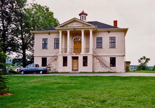
Annapolis County Court House National Historic Site of Canada
Annapolis Royal, Nova Scotia
Annapolis County Courthouse National Historic Site of Canada is a
handsome building in the Palladian style. Prominently located on one of
Annapolis Royal's major streets, it is raised upon a high foundation
storey of rusticated stone, and consists of a symmetrical facade with
prominent central portico, all under a gracefully curving hipped
roof.
The heritage value of this courthouse resides in its historical
associations as reflected in its design and historic fabric. One of the
oldest courthouses in Canada, it was constructed in 1837, and enlarged
in 1922-23. Still in original use, it continues the local presence of
the British-based judiciary, which dates from 1721. Builder Francis
LeCain designed it in association with the county grand jury, a common
process in early-19th-century Nova Scotia. The symmetrical facade, with
its raised central projection and columned portico, is a hallmark of the
Palladian style and typical of courthouses of that era throughout the
British Empire. Prominently situated within a neighbourhood of 18th- and
19th-century buildings, the courthouse enhances the historic character
of the town of Annapolis Royal.
|
©Parks Canada Agency / Agence Parcs Canada, Ian Doull
©Parks Canada Agency / Agence Parcs Canada, Ian Doull |
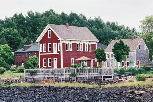
Annapolis Royal Historic District National Historic Site of Canada
Annapolis Royal, Nova Scotia
Annapolis Royal Historic District National Historic Site of Canada is
situated at the junction of the Annapolis and Allain Rivers, in Nova
Scotia's Annapolis Valley. The district's historic core, consisting of
commercial, military, and residential districts, lies at the centre of
the original early 17th-century Acadian area of settlement. The district
extends back from the waterfront, encompassing a densely built
collection of 18th- through early 20th-century buildings exhibiting the
Maritime vernacular interpretation of several architectural styles. The
town's strategic setting, bordering the protected Annapolis Basin with
access to the Bay of Fundy, made it the site of pivotal events
throughout the early years of colonisation in Canada.
French colonists first began to cultivate Annapolis Royal Historic
District, then known as Port-Royal, in 1605, but in 1613 the colony was
seized by the British. In 1632, Acadia was restored to France by treaty
after which the site was fortified and became the principal settlement
of Acadian colonists. In 1643, a four-bastioned earthwork was
constructed at Fort Anne, and by 1650 the beginnings of a town site
existed. St. George Street, a main road of the district, was well
developed by 1686. Acadia was ceded to Britain in 1713, and Port-Royal
was re-named Annapolis Royal. It served as the centre of military and
administrative operations for the new British colony of Nova Scotia
until 1749 when Halifax became the provincial capital. By virtue of its
waterfront location, Annapolis Royal was well established in
shipbuilding, brick manufacturing and lumber milling, which expanded and
diversified the local economy.
Annapolis Royal is characterized by continuous development, resulting in
a wealth of architectural styles and the evolution of five distinct
subdistricts within the site. The first subdistrict is distinguished by
grand houses on large lots, reflective of the prosperity of its shipping
merchants. The second subdistrict, a transitional area between
residential and commercial districts, is distinguished by smaller houses
with less pronounced set-backs. Landscapes such as the old cemetery and
Fort Anne link it with the earliest decades of permanent European
settlement. The third subdistrict was developed as a commercial
district, and exhibits a variety of architectural influences, harmonized
through the use of similar construction materials. The fourth
subdistrict, located on Lower St. George Street, contained some of the
town's river-based commercial and industrial enterprises and housed some
of the most prominent citizens as reflected in the grand homes. The
fifth subdistrict is a residential area, characterized by buildings of
modest size and design, which housed tradesmen, shopkeepers, and
proprietors of small business.
The town retains extant buildings and structures from all but the
earliest of these periods, and as such contains a detailed catalogue of
Maritime and Canadian building traditions. Widely regarded as the oldest
continuously inhabited settlement in Canada, this exceptional collection
of buildings reflects the themes of Acadian settlement, as well as the
building of colonial capitals, Loyalist towns, and 19th-century
commercial centres.
|
©Parks Canada Agency / Agence Parcs Canada, 1987 |
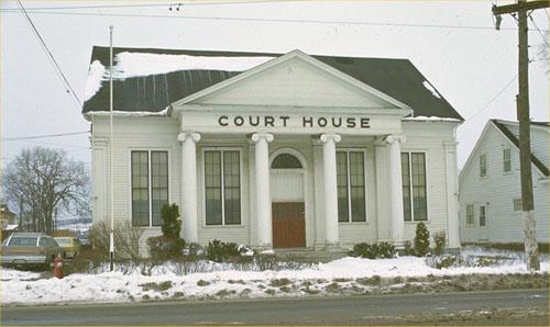
Antigonish County Court House National Historic Site of Canada
Antigonish, Nova Scotia
Antigonish County Court House is situated in the town of Antigonish on
the northeastern shore of mainland Nova Scotia. Built in a simple,
vernacular style, the Court House is symmetrical, wood-frame building.
It is distinguished by a Greek revival, temple-like front consisting of
a pedimented portico supported by four large fluted columns. The county
jail, built of stone, is attached at the rear.
Antigonish County Court House was designated a national historic site of
Canada in 1981 because it is one of the best examples in Nova Scotia of
the typical mid-19th century Maritime Court House.
The court houses erected in Nova Scotia toward the mid-19th century were
small wooden buildings which accommodated a large court room, a judge's
chambers, a barrister's room, as well as rooms for grand and petit
juries. They were simple frame buildings, the design of which
incorporated classicized ornamental details, giving them a monumental
presence suitable for courts of law. The Antigonish Court House is a
good example, designed and constructed in 1855 by local carpenter
Alexander McDonald. The building has undergone some modifications,
having survived a major fire in 1945 and having undergone subsequent
renovations. It continues to serve as a court house.
|

©Parks Canada Agency / Agence Parcs Canada, P. Muise, 1999 |
Argyle Township Court House and Jail National Historic Site of Canada
Tusket, Nova Scotia
Argyle Township Court House and Jail National Historic Site of Canada is
a simple but elegant two-storey wooden building constructed from 1802 to
1805 in the New England Meeting House form. Located at the corner of
Highway 3 and Court Street in Tusket, Nova Scotia, it now serves as a
museum and archives.
The heritage value of Argyle Township Court House and Jail National
Historic Site of Canada resides in its age, its illustration of its
original function, and in its architectural quality.
Argyle Township Court House and Jail was built between 1802 and 1805 in
order to house the General Sessions of the Peace for the District of
Yarmouth and Argyle. It was expanded in 1833 and again in 1870,
eventually expanding to three times its original size. The jail closed
in 1924, followed by the the court house in 1944. From 1945-1976 it
served as offices for the Municipality of Argyle until it was restored
in 1982. Since 1983, it has been operated as a heritage site, museum and
archives.
|

©Parks Canada Agency / Agence Parcs Canada |
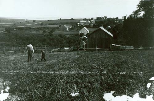
Beaubassin National Historic Site of Canada
Fort Lawrence, Nova Scotia
Major Acadian settlement; pivotal place in the 17th- and 18th-century
North American geopolitical struggle between the British and French
empires.
Beaubassin National Historic Site of Canada is located on the
southwestern edge of Fort Lawrence Ridge, formerly known as Beaubassin
Ridge, in Nova Scotia. The site, largely comprised of hayfields, pasture
and marshland, is divided into two parts by the main Canadian National
Railways line, and also contains Fort Lawrence National Historic Site of
Canada.
Beaubassin was a major Acadian settlement founded between 1671 and 1672
on the Isthmus of Chignecto Isthmus, a significant place in the 17th and
18th century territorial disputes between the British and the French.
The village, where residents farmed, raised livestock and were involved
in shipbuilding, lay at the heart of a vast trading network encompassing
Île Royale, Nova Scotia and New England. In the spring of 1750, the
Governor of Nova Scotia, General Edward Cornwallis, ordered Major
Charles Lawrence to push the French troops out of the Chignecto region,
and in late spring, Lawrence landed with 400 men in the swamps west of
Beaubassin. Lawrence was unable to take the Beaubassin Ridge, but
nevertheless witnessed the burning of Beaubassin — apparently by the
French themselves. The burning of Beaubassin and the militarization of
the Isthmus by the French and the British radically changed the
geopolitical situation because, soon thereafter, the Acadians fled en
masse to French territory or, locally, to refuge on Beauséjour Ridge.
Although modern agricultural buildings and homes have impacted the
archaeological resources, much of the land is still agricultural or
marshland. The pastured fields of the former Beaubassin village contain
good archaeological evidence of the Acadian occupation.
|

©Nova Scotia Museum/ Musée de Nouvelle-Écosse, |
Bedford Petroglyphs National Historic Site of Canada
Halifax, Nova Scotia
Spiritually significant petroglyph site
|
©Parks Canada Agency / Agence Parcs Canada, 2006 |
Black-Binney House National Historic Site of Canada
Halifax, Nova Scotia
Black-Binney House National Historic Site of Canada is an elegantly
restrained, three-storey, cut-stone house that sits close to the
sidewalk on a downtown street in Halifax, Nova Scotia. Its symmetrical
design and restrained decorative finishes reflects the tradition of
Palladian-inspired residences during the late eighteenth and early
nineteenth centuries in eastern Canada.
Built ca. 1819 for merchant and politician John Black, the Black-Binney
House enjoyed a succession of prominent residents including the
Honourable James Boyle Uniacke, Premier of Nova Scotia from 1848 to
1854, and the Anglican Bishop of the province, the Right Reverend
Hibbert Binney from about 1855 to 1887. This house was large for its
time and finished to a very high level with finely cut granite facing on
the facade, wrought iron railing along the entry steps, decorated
leading in the entry door lights, and fine wood and plasterwork on the
interior. Its symmetrically arranged sash windows, low hipped roof and
central entry place it within the tradition of vernacular
interpretations of Palladian design, popular for homes of the middle and
upper classes during this era.
|
©Parks Canada Agency / Agence Parcs Canada |
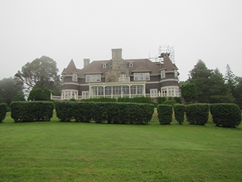
Beinn Bhreagh Hall National Historic Site of Canada
Baddeck, Nova Scotia
Built in 1892-93, Beinn Bhreagh Hall (BBH) was the summer residence, estate,
and laboratory of inventor and scientist Alexander Graham Bell and his wife,
Mabel Bell. It is a grand Queen Anne Revival/Shingle style residence, an
outstanding example of this architectural style that was popular in New
England and favoured on the American seaboard. It features original stone
fireplaces and interior workmanship, and its lush gardens were created by
Mabel Bell. BBH was an inspiration to Alexander Graham Bell during his late
career, serving as both a private home and the nerve centre for innovative
experiments with kites, tetrahedral construction, and hydrofoils, as well as
sheep breeding.
The Bells were a prominent American family whose permanent residence was in
Washington, DC. They began summering in Nova Scotia in 1885, and in 1892,
began construction of BBH as a summer home. In fact, they liked Baddeck so
much that they often lived there for much of the year, even building research
laboratories nearby. Their home was a welcoming centre to scientists and
local residents who often visited and partook of lively discussions.
Alexander Graham Bell had a prolific mind and was always exploring new ideas.
He often hired local townspeople to assist in his experiments. While residing
at BBH, he conducted research in many fields including sound transmission,
medicine, aeronautics, marine engineering, and space-frame construction. It
was here that, in 1907, Mabel and Alexander Bell founded the Aerial
Experiment Association which developed four prototype airplanes, including
the Silver Dart, which flew across Bras D'Or Lake in February 1909.
Located at the point of Red Head Peninsula between Beinn Bhreagh Mountain and
Bras D'Or Lake, BBH affords magnificent views of the lake and the town of
Baddeck. The Queen Anne Style, two-storey residence features a massive
central-tiered stone chimney, a large central sun porch with wood railing and
large windows, and two large turrets which wrap around the corners of the
house. Its 11.7 hectares (28.9 acres) of landscaped gardens benefit from an
unusually warm microclimate and feature a number of rare plants, including
Cypress trees and Japanese Barbery. A three-tiered garden with annuals,
perennials, and a magnolia tree planted in 1913 are located to the north of
the house. Designed by Arthur G. Everett with input from the Bells, BBH is
one of the few surviving examples of an Atlantic Canadian 'summer' home built
by a prominent American. It retains much of its original features, speaking
to its role as the central hub of a unique scientific and technical
'laboratory' created by Bell, his wife, and associates.
|
©Parks Canada Agency / Agence Parcs Canada, Mainland Nova Scotia Field Unit / Unité de gestion de la Nouvelle-Écosse continentale |
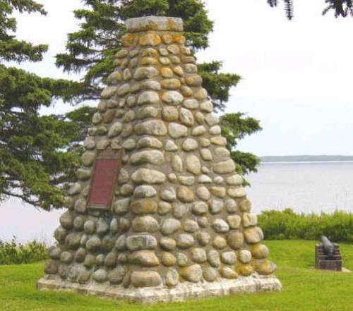
Bloody Creek National Historic Site of Canada
Bridgetown, Nova Scotia
Site of two French-English combats, 1711 and 1757.
Bloody Creek National Historic Site of Canada is located on sloping
farmland in Bridgetown, Nova Scotia. Two circles of land mark the sites
of two battles, which took place in 1711 and 1757, between British
forces and allied French and Aboriginal forces over the possession of
Acadia. The first battle site is centred on the northwest shore of the
Annapolis River, and the second site is centred on the east shore of
Bloody Creek. Both are comprised of land and water. A Historic Sites and
Monuments Board of Canada stone cairn, near the site of the 1757 battle,
marks the location.
Bloody Creek was designated a national historic site of Canada in 1930
because: it commemorates the two combats between British garrisons of
Annapolis Royal and allied French and Aboriginal peoples in the half
century of conflict for possession of Acadia.
The British had captured Annapolis Royal, known as Port Royal under the
French Regime, in 1710. On June 9, 1711 approximately 60 British
soldiers of the 500 man garrison set out from their fortification of
Annapolis Royal to investigate why local Acadians were only supplying
half of the quota of trees required to make repairs to the fort, and to
enforce the request. The next day, the British troops, who were
travelling in three boats, were ambushed by pre-warned French forces at
a narrow part of the LaHave River and either killed or taken
prisoner.
The second attack on the British garrison from Annapolis Royal at Bloody
Creek was a result of the deportation of the Acadians in 1755. Roving
bands of dispossessed Acadians appeared intermittently around British
fortifications to attack troops whenever possible. In 1757, 130 British
soldiers sent to destroy bands of Acadians again fell prey to an ambush,
this time on the west side of the bridge over the Renne Forest brook,
which was later re-named Bloody Creek. The Acadians opened fire as
British troops attempted to cross the bridge, killing 18 soldiers, and
losing 7 of their own. The two battles are demonstrative of the
guerrilla warfare tactics used by French soldiers and their allies
during the volatile period of the mid- to late- 18th century in
Acadia.
|
©Parks Canada Agency / Agence Parcs Canada |
Canso Islands National Historic Site of Canada
Canso, Nova Scotia
Site of fishing centre, 16th- to 19th-century.
The Canso Islands National Historic Site of Canada consists of a group
of islands located off the eastern tip of mainland Nova Scotia, within
easy access of the offshore fishing banks. The site consists of Grassy
Island, which is connected by a cobble beach to George Island; and
Piscatiqui Island, which was linked to George Island until 1779 when a
channel was opened between them. These three islands have at various
times been known as Canso Island, the Great Island of Canso, the Canso
islands, Great and Little Canso Islands, Canso Island and Cape Ann,
Canso and Binney Islands. A number of smaller islands are also included
within the site. They are located north of the three larger islands in
an area historically referred to as "Back of the islands." The waters
between the islands provide sheltered anchorages. The site includes
Grassy Island Fort National Historic Site of Canada, located on Grassy
Island itself.
The heritage value of Canso Islands National Historic Site of Canada
lies in the historical associations with the fishing industry since the
pre-contact era and with the French-English struggle for control of
Canada as illustrated by the combination of natural features and the
remains of military and fishing activity found there.
The islands in Canso Harbour have been an important centre for the North
Atlantic fisheries since the 16th century, as they offered a safe haven
for fishermen. The Canso Islands were first frequented by the French and
the Basques in the 1550s, and became the site of an extensive New
England fishing establishment during the first half of the 18th century.
Here fishermen dried their catch before shipment to markets in Europe
and the West Indies. Until its destruction by the French in 1744, Canso
was the economic mainstay of the colony of Nova Scotia and a key centre
for the English cod fishery. The town of Canso continues this fishing
tradition.
The Canso Islands also played an important role in the French-English
struggle for control of Canada. For example, it was the scene of several
skirmishes between the British and the French and the Mikmaq during the
first half of the 18th century. It was also the staging point for the
British expedition led by Sir William Pepperrell and Sir Peter Warren
against the French stronghold of Louisbourg in 1745.
|

©Parks Canada Agency / Agence Parcs Canada |
Cape Breton Highlands National Park of Canada
Headquarters: Ingonish Beach, Nova Scotia
Home to Cabot Trail, a land blessed with spectacular cliffs.
Cape Breton Highlands National Park is known for its spectacular
highlands and ocean scenery. Steep cliffs and deep river canyons carve
into a forested plateau bordering the Atlantic Ocean. One third of the
Cabot Trail, a world-famous scenic highway, runs through the national
park along the coasts and over the highlands.
The cool, maritime climate and rugged landscape permit a unique blend of
Acadian, Boreal and Taiga habitats, including old-growth forests of
international importance.
|
©Parks Canada Agency / Agence Parcs Canada |
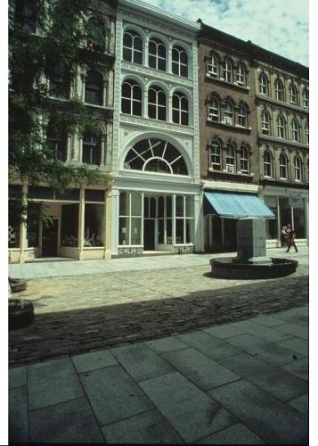
Cast Iron Façade / Coomb's Old English Shoe Store National Historic Site of Canada
Halifax, Nova Scotia
The Cast Iron Façade / Coombs Old English Shoe Store is a
mid-19th-century commercial building with a cast-iron facade. It is
located in the Granville Street area of downtown Halifax. The Coombs
building forms part of a block of historically and architecturally
significant commercial buildings.
The Cast Iron Façade / Coombs Old English Shoe Store was designated a
national historic site in 1980 because it provides a rare and early
example of a full, cast-iron facade in Canada.
Built in 1860, the Coomb's building is one of the first cast-iron-front
structures constructed in Canada and the only building in Halifax known
to have a facade composed entirely of cast iron. The four-storey facade
was designed and manufactured by the Architectural Iron Works of New
York City, a major supplier and promoter of cast iron architecture in
North America.
|

©Clara Dennis, Nova Scotion Museum, Halifax, William Dennis Collection, 1930 |
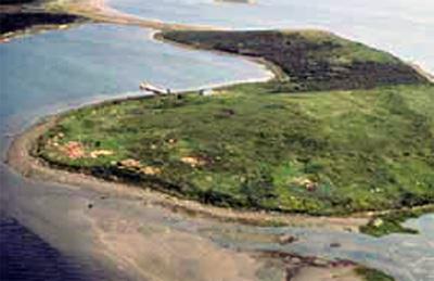
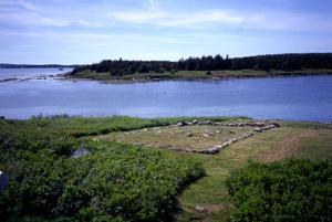
Chapel Island National Historic Site of Canada
Chapel Island First Nation, Nova Scotia
Chapel Island, approximately 2 kilometres long and one kilometre wide,
is located in the southeastern corner of the Bras D'Or Lake on Cape
Breton Island, where it forms part of the larger Chapel Island First
Nation reserve. Since pre-contact times it has been a traditional
gathering place and a site sacred to the Mi'kmaw people. The cultural
landscape includes what are believed to be many unmarked burials and
archaeological remains as well as visible evidence of human activity
concentrated in the southern portion. Here are found marked graves, a
boulder associated with the 18th-century Abbé Maillard, two circular
depressions, stations of the cross, dozens of summer cabins, and a small
church.
Chapel Island is a major gathering place for the Mi'kmaq in Atlantic
Canada and has been used as such, according to Mikmaw oral tradition,
since before contact with Europeans. During the 18th-century the French
missionaries, of whom the best known was Abbé Maillard, established
Roman Catholic missions. Ongoing missions on Chapel island are central
to the spiritual significance of the island. The annual gathering in
late July for the Feast of St. Ann draws Mikmaq people from all over the
Atlantic region. Chapel Island continues to be regarded as a place of
great spirituality and the cultural cradle of the Mikmaq peoples.
|
©Parks Canada Agency / Agence Parcs Canada, 1980 |
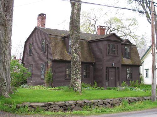
Chapman House National Historic Site of Canada
Fort Lawrence, Nova Scotia
Chapman House National Historic Site of Canada is a two-storey red-brick
house which preserves the "Georgian" form, typical of a prosperous
eighteenth-century east coast farmhouse.
Located in Fort Lawrence, Nova Scotia, the house sits on a knoll,
overlooking the Amherst Marsh and LaPlanche River.
Chapman House was designated a national historic site of Canada because
it preserves the basic form and many of the details of a prosperous late
18th-century farmhouse.
The house was built by Charles Dixon and William Chapman Junior for
Major Thomas Chapman, in the tradition of the British classical
vernacular of the time. Chapman, one of several English immigrants
settling this area in the 1770s, pursued farming on the fertile marsh
and dyke lands already developed by the Acadians.
|

©Parks Canada Agency / Agence Parcs Canada, 2005 |
Charles Fort National Historic Site of Canada
Annapolis Royal, Nova Scotia
Charles Fort (formerly known as Scots Fort) was built in 1629 by the son
of Sir William Alexander.
Located on the grounds of Fort Anne National Historic Site of Canada,
Charles Fort (formerly known as Scots Fort) was built in 1629 by the son
of Sir William Alexander as a base for the colony of Nova Scotia ('New
Scotland'), granted to Alexander by James I of England and VI of
Scotland in 1621. Scottish colonists occupied the fort from 1629 to 1632
when Nova Scotia, known to the French as Acadia, was restored to France
by peace treaty. Charles Fort forms part of the important story of early
European colonization in Canada and was designated a national historic
site in 1951. The remains of Charles Fort have been protected for
centuries by being buried under Fort Anne's outer works. These remains
are not apparent on the grounds.
Located underneath the restored Fort Anne National Historic Site of
Canada, there are no above ground resources to show where Charles Fort
once had been. Nevertheless, from the site where the fort once stood,
one can look out over the confluence of the Annapolis and Allain
Rivers.
Charles Fort was erected in 1629 by Sir William Alexander, as the base
for his colony of New Scotland, or "Nova Scotia" in Latin. James I of
England and VI of Scotland had granted this colony to Sir Williams
Alexander by charter in 1621. The charter covered the geographical area
made up today of the Maritime Provinces and the Gaspé peninsula. At this
time, the French claimed part of this area as Acadia and the Aboriginal
peoples knew it as Mi'kmaki. Scottish colonists occupied the fort from
1629 to 1632 when Nova Scotia was restored to France by peace treaty.
Charles Fort forms part of the important story of early European
colonization in Canada.
|
©Parks Canada Agency / Agence Parcs Canada 1993 |
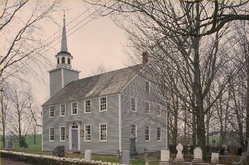
Covenanters' Church National Historic Site of Canada
Grand-Pré, Nova Scotia
Covenanters' Church National Historic Site of Canada is a handsome,
well-proportioned, classically designed wooden building expressive of
the typical 18th-century meeting house in New England. A square tower
with a small belfry and spire complement the pleasing proportions of
this simple two-storey, rectangular church. Careful attention to detail
is evidenced in its symmetry, in the regularly placed windows and in its
centrally placed entrance. The sober, dignified treatment of the
exterior is complemented by its setting in a treed, manicured churchyard
surrounded by a small stone wall. Sited on a hill overlooking Grand-Pré,
Nova Scotia, it is also a component of the Grand-Pré Rural Historic
District National Historic Site of Canada.
The heritage value of the Covenanters' Church resides in its physical
expression of the New England meeting house form. Originally built as a
towerless Presbyterian meeting house, this simple frame church is
commonly dated between 1804 and 1811. It received the Covenanter label
some decades after its construction when the congregation renewed
adherence to the covenant of their ancestors. The rectangular form with
a five-bay front and entrance on the long side is characteristic of the
18th-century New England meeting house although the second-storey
windows and galleried interior are more elaborate than normal. The
interior features a high pulpit and octagonal sounding board with
beautifully moulded and panelled woodwork. This laterally organized
chapel eventually received a tower and steeple appended to a gable
end.
|

©Parks Canada Agency / Agence Parcs Canada, Miriam Walls, 2006 |
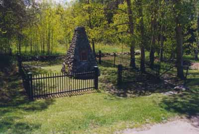
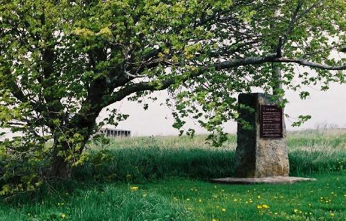
D'Anville's Encampment National Historic Site of Canada
Halifax, Nova Scotia
Encampment of failed French expedition to recover Acadia, 1746.
D'Anville's Encampment National Historic Site of Canada is located on a
small plot of land in Centennial Park in Bedford Basin, Halifax, Nova
Scotia. It was in this area, in 1746, that Duc d'Anville camped along
the shore on a failed expedition from France to recover Acadia. The site
consists of a Historic Sites and Monuments Board of Canada (HSMBC)
plaque and cairn surrounded by a five-metre radius in Centennial Park.
There are no known extant remains associated with Duc d'Anville's 1746
encampment, and its precise location remains unknown.
A year after Louisbourg fell to the British in 1745, France sent an
armada of warships across the Atlantic to retake and dismantle the
fortress, to take Annapolis, and to attack Boston. The expedition was
led by Jean-Baptiste-Louis-Frédéric de la Rochefoucauld de Roye, Marquis
de Roucy and Duc d'Anville, who is often referred to as Duc d'Anville or
d'Anville. The powerful fleet started with 70 ships, 10,000 sailors, and
upwards of 3,000 soldiers. When d'Anville arrived in Chebucto (Halifax
Harbour) on September 10, 1746, the fleet included only three war ships
and a few transports; the rest had been scattered or sunk due to severe
storms. Many men perished, mainly of food shortages, typhus, dysentery,
and scurvy. The remaining crews camped on the beach where many continued
to succumb to illness. On September 27th, d'Anville himself died and
control of the fleet passed to Jacques-Pierre de Taffanel de la
Jonquière, Marquis de La Jonquière, who later became a Governor of
Canada. La Jonquière returned to France with the remaining fleet in
October, losing more ships and men due to further storms and
sickness.
|
©Heritage Division, NS Dept. of Tourism, Culture and Heritage, 2007 |
de Gannes-Cosby House National Historic Site of Canada
Annapolis Royal, Nova Scotia
The de Gannes-Cosby house at 477 St George Street is a rectangular one and one
half storey wooden structure with an ell. The building was constructed in 1708
in the Acadian style. It is of post and beam framing and is sheathed in
clapboard. One of its dominant features is its steep gambrel roof. The house
sits close to the road on Upper St George Street in the residential part of
town. The municipal designation includes both the house and the property.
The de Gannes-Cosby house is the oldest documented wooden structure in Nova
Scotia and has been continuously occupied since its construction in 1708 by
Major Louis-Joseph de Gannes de Falaise, a French nobleman and officer with the
garrison who had arrived at Port Royal in 1701. His first house was burned in
the 1707 attack on the town and the following year he rebuilt on the site
incorporating the existing foundation and standing chimneys. De Gannes and his
third wife, Marguerite Le Neuf de La Valliere, daughter of a former governor of
Acadie, lived here with their large family until the final capture of Port Royal
by the British in 1710. After the surrender, they returned to France with the
rest of the French garrison and as a government official, de Gannes forfeited
his property to the British crown.
When Major Alexander Cosby, an Irish aristocrat with Phillips' Regiment, was
appointed Lieutenant-Governor of the Town and Fort of Annapolis Royal in 1727,
possession (but not ownership) of the property went with the post. Cosby, a
brother-in-law of Governor Richard Phillips, was in Annapolis Royal by 1721. His
influence was enhanced with his marriage in 1726 to Ann Winniett, daughter of
William and Marie-Madeleine (Maisonnat) Winniett, leading figures in the town in
the years after British conquest. A divisive figure in the political life of
Annapolis Royal, Cosby remained a key player in the affairs of the colony until
his death in 1742. Ann Cosby continued to live in the house another 46 years
until her death in 1788. Their son Phillips Cosby (circa 1729 - 1808) became the
first native-born Nova Scotian to reach the rank of Admiral and inherited the
family estates in Ireland.
Following the death of Ann Cosby, her heirs in Great Britain rented the property
through Annapolis Royal lawyer Thomas Barclay, who had been given their power of
attorney. In 1809 it was sold to the Reverend Cyrus Perkins, the Anglican rector
of St Luke's Church, apparently without protest from the British Crown. In 1816,
the property was bought by Dr. George Henkell, former German staff surgeon in
the Royal Fusiliers, who had become garrison surgeon in Annapolis in 1796. He
married Margaret Fraser, daughter of James Fraser, Ordnance Storekeeper at Fort
Anne in the late eighteenth century. Members of the related Henkell, Fraser,
Robinson, Tobias and Smith families owned the de Gannes-Cosby house until 1877
when it was sold to master mariner Benjamin Nickerson. In 1921 the house was
purchased by Arthur W. Banks and remained with the Banks and related Wetmore
families until 1983.
The de Gannes-Cosby house, built in the Acadian style, is one of the few
buildings dating from the French regime in Nova Scotia (prior to 1710) that is
still standing. The building is also a rare example of early Acadian
architecture, as most buildings in this style were destroyed by the British
during the 1755 deportation. The house itself is a one and one half storey
building with a rectangular footprint and an ell. The walls of the post and beam
structure were originally finished with clay wattle and daub infill. There is a
rubble foundation with a partial basement under the building. The building is
clad with wooden clapboard with wooden end boards. The wooden front door is
centrally located in a two storey enclosed porch with sidelights. The windows
are wooden six over six double hung sash windows with moulded trim. The building
features a distinctive gambrel roof with two front side dormers with pediments
which were added in the twentieth century. The ell features three gabled dormers
with overhangs. There are two brick double chimneys on the main section of the
house and a single brick chimney on the ell.
|

©Parks Canada Agency / Agence Parcs Canada |
Debert Palaeo-Indian Site National Historic Site of Canada
Debert, Nova Scotia
Debert Palaeo-Indian Site National Historic Site of Canada is comprised
of five archaeological sites situated in similar topographic and
ecological niches. They are located along the top of glacial ridges
between small stream valleys, which run from the Cobequid Plain up into
the Cobequid Highlands in Colchester County, Nova Scotia. The sites were
used by Palaeo-Indian hunters from 8500 BCE to 9000 BCE as seasonal
camps where they monitored the movement of caribou herds and
manufactured tools.
The heritage value of Debert Palaeo-Indian Site lies in the similar
geographic location of its archaeological sites, the nature of the
artifacts they contain, and the knowledge they contribute to
understanding North American Palaeo-Indian cultures. Palaeo-Indian sites
are found throughout North America. The Palaeo-Indians of Debert,
distant ancestors of later Mi'kmaw and other Aboriginal populations in
eastern Canada, were the descendants of the Aboriginal peoples who
possibly crossed the Bering Strait during and after the Wisconsinian
Glacial Stage, and settled in the southern region of North America. From
this central area, they eventually spread east and north into the
Maritimes. The archaeological sites at Debert, which were used as
seasonal camps for nomadic big game hunters, represent the initial human
settlement of Atlantic Canada, from around 8500 to 9000 BCE. The
relatively intensive occupation and indication of varied activities
makes the Debert Site unusual.
The site was the subject of extensive excavations during the 1960s, and
was expanded following the discovery of two new Paleo-Indian habitation
sites. Since then, two further sites have been located making a total of
five known Paleo-Indian archaeological sites on these properties. Some
of these sites have been considerably disturbed by 20th-century
construction. A remarkable collection in term of size and diversity, the
artifacts from Debert have come to define the eastern expression of
Palaeo-Indian culture in northeastern North America. The archaeological
sites at Debert also exhibit the earliest known Paleo-Indian occupation
and the most well recorded Paleo-Indian sites in Atlantic Canada.
|
©Parks Canada Agency / Agence Parcs Canada |
Fernwood National Historic Site of Canada
Halifax, Nova Scotia
Fernwood National Historic Site is a Gothic Revival-style villa set in a
large landscaped property with outbuildings on the slope of a hill
leading to the North West Arm in Halifax, Nova Scotia.
Fernwood was designated a national historic site in 1990 because it was
a fine representative example of a Gothic Revival villa.
The heritage value of this site resides in its physical expression of
the Gothic Revival style as used for suburban residential properties in
the late nineteenth century. The villa was a distinct type of residence.
It was large enough to require a small domestic staff: it was attached
to a parcel of landscaped property, and yet it was not so large as to be
pretentious. It was a building whose architectural style had been
carefully considered. The lifestyle implied was one of comfort, rural
calm, agrarian gentility, and unquestioned social privilege.
Fernwood was designed by architect David Stirling and built in Halifax
c. 1860.
|
©Parks Canada Agency / Agence Parcs Canada, P. McCloskey, 1974
©Parks Canada Agency / Agence Parcs Canada, 1994

©Parks Canada Agency / Agence Parcs Canada, T. Grant, 1977 |
Fort Anne National Historic Site of Canada
Annapolis Royal, Nova Scotia
1695-1708 fortifications.
Fort Anne National Historic Site of Canada is Canada's oldest - a
present-day reminder of a time when conflict between Europe's empire
builders was acted out on the shores of the Annapolis River. It offers a
sweeping view of the beautiful Annapolis Basin from the centre of
Annapolis Royal. Museum exhibits highlight the history of the
fort.
Fort Anne National Historic Site is a fortified site located at the
confluence of the Annapolis and Allain rivers in the town of Annapolis
Royal. Settled since 1629, the fort consists of the remains of various
18th and 19th century buildings and fortifications, the land surrounding
them, and viewplanes over the adjacent salt marshes, river and town.
Specific resources include the powder magazine (1708); the remains of a
Vauban-style French fort (1702-8) with an underground powder magazine, a
parade square well, a covert way well and earthworks; a dry-stone
retaining wall (1760); a 19th-century Sally-port; shoreline cribwork
(1740s); the ruins of the Queen's wharf (1740s); the British Officers'
quarters (built 1797-9 and reconstructed 1934-5); an Acadian cemetery;
and a British garrison cemetery.
Fort Anne National Historic Site is of national historic significance
because of the site's role in early European colonization, settlement
and government in Acadie and Nova Scotia in the 17th and 18th centuries;
in the struggle for empire in the 17th and 18th centuries; as the centre
of changing social, political and military relations among the Mi'kmaq,
the Acadians and the British living in the area throughout the 17th and
18th centuries; and as an example of Vauban-style fortifications that
survive due largely to successive generations of Canadians who treasure
their cultural landscapes.
The site was the location of Charles Fort, settled in 1629-32 by
settlers led by Sir William Alexander as part of his plan for a New
Scotland. Charles de Menou D'Aulnay brought Acadian settlers to the area
in 1636, making the site his Port-Royal headquarters. Acadians began
their distinctive dykeland agriculture here. The French governed Acadie
from successive forts on the site until 1710. From 1713 to 1749, the
British governed Nova Scotia from the fort, re-named Annapolis Royal.
The Deportation of the Acadians from Annapolis Royal, and the settlement
of New England Planters and of Loyalists were all organized from the
site during the 18th century.
As the capital and military centre of Acadie/Nova Scotia, the site
played an important role for local inhabitants. The Mi'kmaq came to the
site to trade, to take part in gift exchanges and to sign treaties.
During the "Indian Wars" of the 1720s, they were imprisoned
here.
Port-Royal and its successive forts were a focal point in the imperial
struggle for control of North America. With each outbreak of war between
England and France, New England launched expeditions against Port-Royal,
capturing it in 1654, 1690 and, for the final time, in 1710. During the
War of the Austrian Succession (1744-8), Quebec and Louisbourg sent
unsuccessful expeditions to retake the fort.
Fort Anne is a classic Vauban fort, designed and built by an engineer
who had studied under European fort designer Sebastian LePrestre de
Vauban. Local residents began to preserve the fortifications, with the
help of the federal government, as early as the late-19th century. In
1917 it was declared a Dominion Park, Canada's first administered
national historic site.
|

©Parks Canada Agency / Agence Parcs Canada, J. P. Jérôme, 1991 |
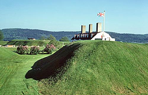
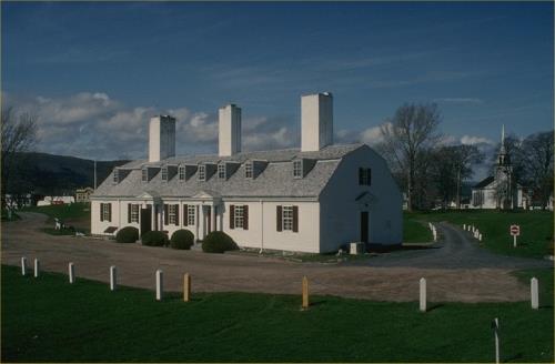
Fort Edward National Historic Site of Canada
Windsor, Nova Scotia
Played a role in the struggle for predominance in North America,
1750-1812; oldest blockhouse in Canada, 1750.
Authentic and illustrative, Fort Edward is the real deal. Step into
another epoch and learn the story of the oldest surviving block house in
Canada. Stand in a place stationed high ona hill overlooking a vast
river valley once inhabited predominantly by the Mi'kmaq and Acadians.
Explore how the British soldiers who stayed here lived and acted. See
why this strategic location was pivotal in helping secure a British
stronghold in Nova Scotia.
Fort Edward National Historic Site of Canada comprises a wooden
blockhouse as well as remnants of buildings and landscape features from
an 18th century fortification on the outskirts of Windsor Nova Scotia
where the St. Croix River joins Pesaquid Lake.
The heritage value of Fort Edward National Historic Site of Canada lies
in its illustration of the British presence during this struggle,
specifically as expressed in the surviving cultural landscape of the
fortress. Fort Edward was built by Major Charles Lawrence of the British
Army in 1750 and originally consisted of a number of wooden buildings
set inside a palisaded square with four bastions, ramparts, a ditch, a
counterscarp and glacis. Its buildings included a blockhouse, two
barracks and a provisions storehouse. Fort Edward was transferred to
national historic sites in 1922. Its blockhouse has been restored and
opened for visitation.
|
©Parks Canada Agency / Agence Parcs Canada, Philip Goldring, 2003 |
Fort Lawrence National Historic Site of Canada
Fort Lawrence, Nova Scotia
English fort, 1750-55.
Fort Lawrence National Historic Site of Canada, located on Fort Lawrence
Road in Cumberland County, Nova Scotia, is an archaeological site lying
atop a gentle ridge surrounded by pasture fields, on the east side of
the Missaguash River. Completely built over by a dairy farm,
archaeological resources relating to this 18th-century fort's former
embankments and trenches, which were visible until 1991, may yet survive
under the dairy barn and yard. Further archaeological remains survive
across the entire property administered by Parks Canada. The official
recognition refers to a polygon that includes the former footprint of
the fort's earthworks.
A highly strategic area, the site was occupied for nearly a century
before the construction of Fort Lawrence. In 1672, Jacques Bourgeois and
other settlers from Port Royal founded the Acadian village of
Beaubassin, which grew into a thriving village and one of the largest
Acadian settlements. However, in 1750, the French learned of an
advancing British army under Major Charles Lawrence and burned the
village to the ground. The French, under Louis de la Corne, Chevalier de
la Corne, withdrew west across the Missaguash River where they began
securing territory. Although Major Lawrence was mandated to secure
territory east of the River, his forces were unable to secure the
eastern ridge, and French soldiers, along with their Acadian and
aboriginal allies drove the British from the area. The British withdrew
to Halifax, returning in the fall of 1750 to the east side of the
Missaguash River, where they erected Fort Lawrence, which consisted of
three large wooden barrack frames and two wooden blockhouses. The French
responded by constructing Fort Beauséjour on the opposite ridge the
following year. In 1755, a British expedition captured Fort Beauséjour
and renamed it Fort Cumberland. It became the British garrison and Fort
Lawrence was abandoned.
|
©Parks Canada Agency / Agence Parcs Canada |
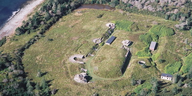
Fort McNab National Historic Site of Canada
Halifax, Nova Scotia
Fort built in 1889 to defend Halifax Harbour.
On McNabs Island, visit the grassy ruins of a fort that served, along
with York Redoubt, as a key element of harbour defence from 1888 to the
Second World War. In summer, the island is accessible by private ferry
from Cable Wharf in downtown Halifax. This National Historic Site of
Canada is part of the Halifax Defence Complex.
Fort McNab National Historic Site of Canada is situated on the southwest
coast of McNabs Island at the entrance to Halifax Harbour. The site is
composed of remnants of late 19th- and early 20th-century defensive
works, including a fort with a buffer of land surrounding it and two
adjacent enclaves encompassing the southern searchlights and numbers 1
to 3 range finders. Fort McNab also includes various historic viewplanes
associated with surveillance and defence.
The heritage value of Fort McNab lies in its strategic location on an
island at the mouth of Halifax Harbour, and in the diffuse and varied
remnants of military works constructed between 1880 and 1945 for outer
harbour defence. The cultural landscape of the island bears witness to
significant changes in defence technology and associated military
strategy through the found location, form and materials of Fort McNab
and its components, the structures associated with the search light
emplacements, archaeological remains, landscape features and associated
historic objects.
Fort McNab was built from 1888 to 1892 in response to advances in
military technology that required the relocation of Halifax's strategic
defence works from the inner to the outer harbour.
Its facilities were altered several times to adjust to changing
technology: 1906 (more powerful guns), 1914 (searchlights and changes in
gun technology), 1914-1918 (counter bombardment batteries), 1940-41 (new
battery command post, artillery replacement), 1948 (reactivated for Cold
War activity), 1953 (artillery replacement). The fort was decommissioned
in 1959.
|

©Parks Canada Agency / Agence Parcs Canada, Andrew Waldron, 2010 |
Fort Sainte Marie de Grace National Historic Site of Canada
LaHave, Nova Scotia
First permanent French settlement in Acadia, 1632.
Fort Sainte Marie de Grace National Historic Site of Canada is
strategically located at LaHave, Nova Scotia, on a point of land where
the LaHave River narrows. The land upon which the original fort was
built has now eroded away; a Historic Sites and Monuments Board of
Canada cairn, which marks the site, is situated near the original
location of the fort.
Following the signing of the Treaty of St. Germain-en-Laye in 1632, the
area around the LaHave River narrows was returned to French settlers,
who established permanent settlements in Acadia, where fishing and fur
trapping resources were abundant. Commander Isaac de Razilly, first
Viceroy and Lieutenant-General of Acadia, and a Knight of Malta, built a
fort and established the capital of the colony. The fort became a
farming colony of around 40 residents, complete with a local mill and
chapel. After de Razilly's sudden death in 1636, most of the settlers
moved to Port Royal. The fort was destroyed by fire in the 1650s.
|
©Mr. Ivan Smith, 2003 |
Fort St. Louis National Historic Site of Canada
Port La Tour, Nova Scotia
Fort St. Louis National Historic Site of Canada is situated one
kilometre southeast of Port La Tour, a small town on the south-eastern
tip of Nova Scotia. There are no visible remains of this 17th-century
French Regime fort, which was constructed during the 1620s on Fort
Point, overlooking a small bay on the Atlantic coast. By 1629 Fort Saint
Louis was the sole remaining French military post of significance in
early Acadia. The English were unsuccessful in their attempts to capture
the fort. The site's landscape now consists of a small grassed area with
an HSMBC cairn and plaque surrounded by trees and brush, bounded to the
west and to the east by the shoreline's high water mark.
Fort St. Louis, a French fort near the south-eastern tip of Nova Scotia,
was built in 1623 by Charles de La Tour in connection with the fur
trade. By 1629 the fort was the only remaining French fort in Acadia and
was threatened by Scottish settlers based at Port Royal. Claude de La
Tour, Charles's father, had allied himself with the English. In 1630,
Claude arrived at Fort St. Louis at the head of an Anglo-Scottish
expedition aboard two war vessels. After failing to convince his son to
surrender this last foothold of France in Acadia he led his forces in an
unsuccessful attack on the fort. Having lost his reputation with the
English at Port Royal, Claude de la Tour and his English wife were later
allowed by Charles to live with on the land surrounding Fort St. Louis.
By 1632 Acadia was once again under French control. Archaeological
remains at the site reveal material evidence dating from the early
French period.
|


©Parks Canada Agency / Agence Parcs Canada |
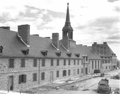
Fortress of Louisbourg National Historic Site of Canada
Louisbourg, Nova Scotia
Reconstruction of 18th-century French fortress.
Fortress of Louisbourg is the largest reconstructed 18th-century French
fortified town in North America, located on the southeast edge of
Louisbourg Harbour adjacent to the Atlantic Ocean in southeastern Cape
Breton, Nova Scotia. It is composed of the site of the original fortress
as well as associated outlying lands and islands, and contains rare
remnants of 18th-century French and British life in North America. Part
of the fortress and town of Louisbourg has been reconstructed to assist
visitors in understanding its scale, complexity and dimension.
The Fortress of Louisbourg was established by France as a critical
fishing, trans-shipment and supply port for its maritime empire. As
administrative capital of the French colonies of Ile Royale including
Ile-St-Jean, it was home to the local government, an established
military garrison and civilian population. It was also an important
mercantile centre for French ships trading around the world and for
development of a North American trading empire based on the fishery. As
such, Louisbourg was a fortified town. It was a strategic base for
protection of the lucrative French fishery and off-shore trade as well
as guarding approaches to the Gulf of St. Lawrence, the main shipping
route to Quebec and the North American interior. As a critical French
asset, Louisbourg was a point of contention between French and British
governments. It was besieged and captured by the British in 1745 and
1758. The British systematically demolished its fortifications in
1760-1768 and abandoned the town by the mid-1780s. Parks Canada has
reconstructed approximately a quarter of the walled townsite
(1961-81).
The heritage value of the Fortress of Louisbourg lies in its historical
associations as illustrated by the surviving remnants of the
18th-century cultural landscape and the massive archaeological
collection.
|
 > >
©Parks Canada Agency / Agence Parcs Canada
 > >
©Georges Island, Geordie Lounsbury, 2007

©Parks Canada Agency / Agence Parcs Canada |
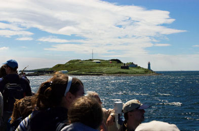
Georges Island National Historic Site of Canada
Halifax, Nova Scotia
Harbour fortification; contains Fort Charlotte.
Georges Island, a small drumlin located in the middle of Halifax
Harbour, was shaped by glaciers thousands of years ago. From the
mid-18th century to World War II, this island was the scene of constant
military activity and played an integral role in the defence of Halifax
Harbour. Tales of hidden tunnels abound in the folklore associated with
this mysterious island.
Georges Island National Historic Site of Canada is a labyrinth of
military works that represented a vitally important element in the sea
defences for Halifax Harbour. They cover a small island situated in the
middle of the harbour directly in front of what today is the Halifax
waterfront.
The heritage value of Georges Island National Historic Site of Canada
lies in its geographic and strategic location in the middle of one of
the finest natural harbours in the world, and in the range of military
works constructed during the 18th, 19th and 20th centuries for inner
harbour defence. The cultural landscape of the island bears witness to
significant changes in military strategy and defence technology through
the found location, form and materials of surviving complexes of
historic buildings, engineering works, fortifications, paths, landscape
features and remains above and below ground, on land and in
water.
The construction of defence works on Georges Island began when Halifax
was established in 1749. Significant periods during which facilities
were upgraded include 1794-1812 (masonry escarp linking north and south
batteries, stone Martello tower - smooth bore ordnance), 1864-1869
(construction of Fort Charlotte with rifled-muzzle-loading ordnance),
1870-1879 (submarine mine period), 1902 (the breech-loading period). The
island continued to play a military role in the Canadian war efforts in
both World Wars. Georges Island became a national historic site in 1960
and has since been conserved.
|

©Government House, Jimmy Emerson, 2010 |
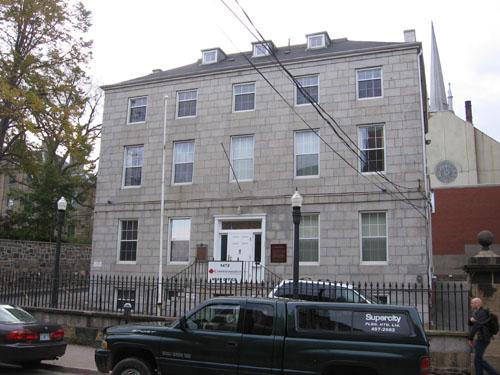
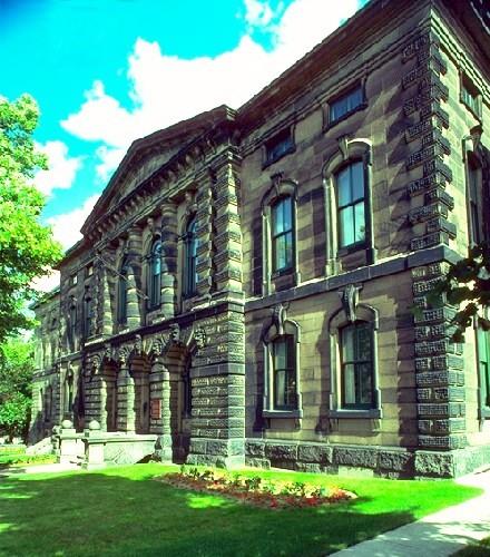
Government House National Historic Site of Canada
Halifax, Nova Scotia
Government House National Historic Site of Canada is located on
Barrington Street in downtown Halifax, close to other early 19th-century
landmarks such as the Old Burying Ground National Historic Site of
Canada and Province House National Historic Site of Canada. It is a
monumental, early 19th-century stone mansion built in the Palladian
style, and is distinguished by its overall symmetry, regularly arranged
double-hung windows, and its recessed three-story central pavilion
flanked by two-storey wings. It is the official residence of the
Lieutenant-Governor of Nova Scotia.
Built from 1799 to 1805 for Sir John Wentworth, the Colonial Governor of
Nova Scotia, Government House has served as an official residence for
more than 175 years. Wentworth, who sought to build a residence
befitting his position, encouraged master-builder and surveyor Isaac
Hildrith to design a building more closely resembling the country estate
of an English gentleman rather than the official residence of a colonial
outpost. Inspired by the Palladian style popular for English country
houses in the late 18th century, Government House incorporates the
classical forms, proportions and detailing typical of that style. It now
functions as the official residence of Nova Scotia's
Lieutenant-Governor.
|
©Parks Canada Agency / Agence Parcs Canada

©Parks Canada Agency / Agence Parcs Canada |
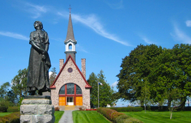
Grand-Pré National Historic Site of Canada
Grand Pré, Nova Scotia
Commemorates Acadian settlement and expulsion.
Grand-Pré National Historic Site of Canada commemorates Grand-Pré area
as a centre of Acadian settlement from 1682 to 1755 and the Deportation
of the Acadians, which began in 1755 and continued until 1762.
Grand-Pré National Historic Site of Canada is located at the former
Acadian village of Grand-Pré, beside the upper Bay of Fundy, north of
Wolfville, Nova Scotia. The site consists of a memorial park created to
commemorate the deportation of the Acadians, who settled in the area
between 1682 and 1755.
The heritage value of Grand-Pré National Historic Site of Canada lies in
its historical associations with the Acadian people and the central role
it continues to play within the Acadian diaspora. This value is
illustrated by the landscaping, the architecture and art that
characterises the commemorative monuments, and by the physical evidence
of early Acadian occupancy.
From 1682 until 1775, the village of Grand-Pré was the centre of Acadian
settlement in the area of Les Mines, on the Mines Basin. In 1755, the
site served as the headquarters for the deportation of over six thousand
Acadians from their lands in Nova Scotia, by the British government.
John Frederic Herbin purchased the site in 1907 to create a memorial
park for the Acadians. In 1917, he sold the land to the Dominion
Atlantic Railway, with the exception of a parcel of land intended for a
memorial chapel. In 1922 the railway hired architect Percy Nobbs to
design a memorial park and the Acadian Société Nationale l'Assomption
hired architect René Frechet to construct a chapel to commemorate the
original Église Saint-Charles. In addition, sculptor Philippe Hébert
created a statue of Évangeline, the heroine of Acadian poet Henry
Wadsworth Longfellow. Although the Deportation took place in several
areas of Nova Scotia, a strong attachment to the area remains among
Acadians throughout the world. In fact, for decades Acadians have come
to the site either individually or in organized groups from as far away
as Louisiana to connect with their history and their ancestral
homeland.
|
©Parks Canada Agency / Agence Parcs Canada |
Grand-Pré Rural Historic District National Historic Site of Canada
Kings County, Nova Scotia
This cultural landscape includes the villages of Grand Pré and
Hortonville, the farmlands which surround them, vast stretches of tidal
marshes, much of which have been dyked to create arable land, and
orchards extending on the uplands. A distinct rural landscape has been
created from the land-use traditions of the Acadians and the New England
Planters. Official recognition refers to the natural and built features,
and evidence of land use patterns and characteristics originating with
the Acadians within the district boundaries.
The heritage value of this cultural landscape resides in the blending of
natural and built features, in the retention and development of land use
patterns originating with the Acadians, particularly in the spatial
distribution of arable land, orchards, dykelands, and residential
hamlets.
|
©Parks Canada Agency / Agence Parcs Canada, 2005 |
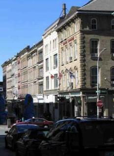
Granville Block National Historic Site of Canada
Halifax, Nova Scotia
Granville Block National Historic Site of Canada is located in the
southern section of downtown Halifax, Nova Scotia, and consists of a
complex of 19 buildings. The buildings are fairly uniform in design and
construction and consist of a brick or stone front, with some stucco
finishes and generally date from the late 19th century. Most have a
commercial ground floor and some have cast iron decoration on the front.
The buildings are now part of the Nova Scotia College of Art and Design
(NSCAD).
In the 18th century and for much of the 19th century, Halifax was a
major distribution and trade centre and Granville Street was a major
commercial thoroughfare. In September 1859, a fire destroyed large
sections of the downtown area, which were quickly rebuilt and became
known for their concentration of novelty shops, haberdasheries and other
stores dealing primarily in dry goods.
The façades of the Granville Block are generally known for their
Italianate style. They are primarily of four or five storeys high and
most of the buildings have a stone or brick façade, although a few are
stucco, and some have cast iron elements on the front. The Italianate
design elements include arched windows, projecting eaves, meticulous
treatment of surfaces and an array of bas-relief sculptures. An
all-concrete building (the Bell Building) was constructed on Granville
Street around 1904; it is one of the oldest concrete buildings in Nova
Scotia.
The heritage value of the block also lies in its role in the history of
urban renewal and conservation in the 1970s. A comprehensive urban
renewal and building rehabilitation initiative took shape in Halifax in
1971-1972. The rehabilitation consisted of making space for retailers as
well as the NSCAD. The approach used was to modernize the utilities,
whilst many period staircases and decorative elements were retained in
order to preserve the authenticity of the place; these include the lath
walls and the exposed concrete in the Bell Building.
|
©Parks Canada Agency / Agence Parcs Canada, P. Kell, 2001 |
Grassy Island Fort National Historic Site of Canada
Canso, Nova Scotia
Centre of English fishery in 18th-century.
Grassy Island Fort National Historic Site of Canada is the remnant of
18th-century British fortifications situated on Grassy Island, one of a
group of islands off the eastern tip of mainland Nova Scotia known
together as the Canso Islands National Historic Site of Canada.
The heritage value of Grassy Island Fort lies in its historical
associations with the fishing industry since the pre-contact era and
with the French-English struggle for control of Canada, as illustrated
by the site and its archaeological remains. Since the Canso Islands were
the centre of rich fishing grounds, fortifications were constructed
twice on Grassy Island Fort to protect them. Neither survived for long.
A small redoubt (1720) and fort (1723-24) were built by the order of New
England Governor Richard Philipps but fell into ruins in the 1730s.
Edward Howe constructed a blockhouse in 1735 that was burnt during a
French attack in May 1744.
|

©Parks Canada Agency / Agence Parcs Canada |
Halifax Citadel National Historic Site of Canada
Halifax, Nova Scotia
Restored British masonry fort, 1828-56.
Halifax Citadel is a large, stone early 19th-century British
fortification located atop Citadel Hill, in Halifax, Nova Scotia. The
walled citadel is surrounded by an expansive grassed glacis descending
to the commons on the west side and downtown Halifax on the east side.
It is the most prominent fortification in a network of defensive works
that have historically guarded Halifax, its dockyard and its
harbour.
The heritage value of Halifax Citadel National Historic Site lies in its
commanding location, in the legibility of its found cultural landscape
as a substantial 19th-century fortification, and in the integrity of
surviving 18th, 19th, and 20th-century remnants of that landscape. These
include all historic resources linked to the landward defence of the
town and to the harbour defences along the water that protected the
naval station.
Although Halifax Citadel was established as a British post in 1749, the
present fort dates from the 1828-1856 period and is its fourth
generation of defence works. The Citadel was occupied by British forces
until 1906, then by the Canadian military as a detention camp during
World War I, and as Halifax headquarters for anti-aircraft defences
during World War II. It became a national historic site in 1956 and has
since been restored for public visitation.
|

©Parks Canada Agency / Agence Parcs Canada |
Halifax City Hall National Historic Site of Canada
Halifax, Nova Scotia
The Halifax City Hall National Historic Site of Canada is a monumental
three-storey, stone municipal building erected in 1887-90. Completed in
an eclectic late-Victorian version of the Second Empire style, this
elaborate composition has a central seven-storey clock tower. It is
prominently located in downtown Halifax, at the north end of the Grand
Parade, opposite St. Paul's Anglican church.
The Halifax City Hall is the largest example of an administrative
municipal hall found in the Atlantic region and reflects the increasing
professionalisation of municipal governments during the late 19th
century. It was one of a handful of single-function municipal buildings
built in growing urban centres across the country before 1900. The first
floor offices were set aside for civic employees requiring a high degree
of public access with additional offices, committee rooms and council
chambers on the second floor, reflecting the practice that council
meetings should not be disturbed. The building also provided space in
the basement for the police department, lockup and court, and for a
library on the second floor. The presence of a public library reflected
the ongoing recognition of importance of education for all
citizens.
Municipal architecture during this period reflected the progressive
outlook of their citizens. The monumental scale of Halifax's City Hall
is underscored by its horizontal massing, masonry construction, and tall
central tower. The elegant design is inspired by the Second Empire
style, popular at that time for large civic structures and features an
eclectic blend of classical decorative elements often found in Victorian
architecture.
Located at one end of the Grand Parade, the City Hall claims an actual
and symbolic centrality in the lives of Haligonians. This public space,
centrally located in downtown Halifax, was laid out as a major public
and military drill square in the city's original plans. The City Hall
anchors the north end of square with St. Paul's Anglican Church National
Historic Site of Canada (1750) at the opposite end. The Cenotaph is
located between the two buildings, completing this public square.
|
©Parks Canada Agency / Agence Parcs Canada |
Halifax Court House National Historic Site of Canada
Halifax, Nova Scotia
The Halifax Court House National Historic Site of Canada is an imposing
mid-19th century, Classical Revival style, stone public building located
on Spring Garden Road, in the heart of historic Halifax, Nova Scotia.
Slightly set back from the road, the symmetrical, three-storey sandstone
building features a gently sloping roof and an elaborately decorated
projecting central section defined by Tuscan columns.
The heritage value of this site resides in its location, setting and
physical illustration of the judicial system in an architecturally
imposing manner. The Halifax Court House is located in the heart of
downtown Halifax, near several other historic buildings, including
Government House, St. Mary's Basilica and the Old Burying Ground, all
national historic sites of Canada.
Designed by Toronto architect William Thomas, the Halifax Court House is
an imposing sandstone structure conceived in the Classical Revival
manner with Italianate detailing. The selection of Thomas, then a major
architect in Canada, is indicative of the county's desire to erect a
handsome building worthy of the city, province, and judicial institution
it would represent. Built from 1858 to 1860, the Halifax Court House
provided permanent space for the Supreme Court of Nova Scotia, with two
courtrooms, judges' chambers, registry offices, and a law library. When
county courts were established in 1875, an additional wing, completed in
1881, was added to accommodate the Halifax County Court. Further wings
were added in 1908 and 1930 to provide additional courtroom and office
space. When new Law Courts were built in 1971, the building became a
Provincial Government library. In 1985 it was restored to serve as a
courthouse for the Nova Scotia Provincial Court.
|

©Department of National Defence / Ministère de la Défence nationale, 1990 |
Halifax Drill Hall National Historic Site of Canada
Halifax, Nova Scotia
Halifax Drill Hall National Historic Site of Canada is a large building
situated across from the common in north central Halifax, Nova Scotia.
Built of red, rock-faced stone in a Richardsonian Romanesque style, the
principal façade of the drill hall is distinguished by an arched troop
door set under a large round-arched window and flanked by smaller arched
windows and matching corner towers. Its distinguishing interior feature
is its large unobstructed drill hall space.
The Halifax Drill Hall is a bold functional design wrapped in a rugged
Richardsonian Romanesque style designed by Thomas Fuller, then Chief
Architect of the Federal Department of Public Works. His designs,
including that of the Halifax Drill Hall, provided the Canadian drill
hall with an architectural vocabulary, which expressed the military
nature of the buildings so well that it was used for a number of
structures long after Fuller had left the department.
Built in response to demands made by the militia in Halifax for a larger
drill hall capable of training their growing number of militiamen, the
Halifax Drill Hall was significantly larger than most other Canadian
drill halls. Its huge size gave the militia one of the largest
uninterrupted interior spaces in Canada. In order to create this large
open interior space, triangular steel Fink trusses were used, marking
the first time all-metal trusses were used in Canadian drill halls.
Proving very satisfactory, the use of this truss system was adopted by
the federal government for almost all larger drill halls constructed
before the First World War.
Also innovative to the Canadian drill hall was the addition of an indoor
shooting gallery, as well as libraries and lecture rooms, which ensured
drill and rifle training would be supplemented with classroom
instruction. Complete with billiard rooms for the officers and bowling
alleys for the men, the Halifax Drill Hall functioned as both a fully
equipped training centre and a recreational club.
The Halifax Drill Hall is also associated with the Princess Louise
Fusiliers, formed in 1869, who saw action in the Riel Rebellion, the
South African War and both World Wars.
|
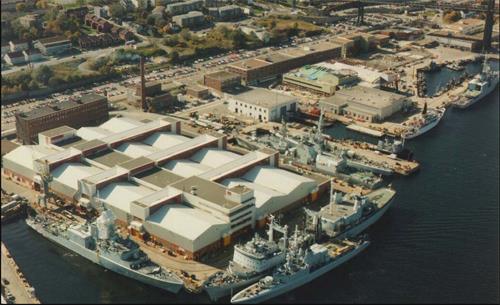
©Canadian Navy, Department of National Defence / Marine canadienne, ministère de la Défense nationale |
Halifax Dockyard National Historic Site of Canada
Halifax, Nova Scotia
Halifax Dockyard National Historic Site of Canada is located on the
Atlantic shoreline at the north end of Halifax Harbour, in Nova Scotia.
It is comprised primarily of wharfs, storage warehouses, and repair,
servicing and docking facilities. As part of Canadian Forces Base (CFB)
Halifax, the site is still in use as a naval depot, for berthing and
servicing naval vessels.
Created in 1758, under the supervision of Captain James Cook, the
Halifax Dockyard was the first royal dockyard in North America. From
1760 to 1815, Britain was almost constantly at war and the dockyard grew
steadily in response to the needs of the Royal Navy. It served as the
principle depot for the North American squadron until 1819, when it was
replaced by Bermuda and became the summer rendez-vous point for the West
Indies and North American squadrons. In 1905 the British left the
dockyard and it was transferred to the Dominion of Canada five years
later.
After the American Revolution, Halifax Dockyard became by default the
oldest military harbour in British North America. Occupied by the Royal
Canadian Navy, it retained its active military function and was pivotal
to strategic defence in the American Revolution, the War of 1812 and the
First World War. Although numerous new buildings were added to the site
during the First World War, the explosion of the Mont Blanc in Halifax
in 1917 destroyed many of the structures. Under the control of Maritime
Atlantic Forces (MARLANT), the Halifax Dockyard continues to be used by
the Canadian navy.
|
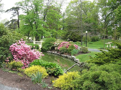
©Halifax Public Gardens, Ndh, 2007 |
Halifax Public Gardens National Historic Site of Canada
Halifax, Nova Scotia
The Halifax Public Gardens National Historic Site of Canada is one of
the rare surviving Victorian gardens in Canada. Located in the heart of
downtown Halifax, Nova Scotia, it is a favourite place for Haligonians
and visitors to stroll and relax. Despite natural changes and occasional
storm damage, the original nineteenth century design remains essentially
intact, including bedding patterns, exotic foliage, favourite Victorian
flowers, subtropical species and tree specimens, serpentine paths,
geometric beds, commemorative statuary, and a bandstand that continue
the traditions of the era.
Halifax Public Gardens was designated a national historic site of Canada
as a rare surviving example of a Victorian public garden. The heritage
value of this site resides in its continued use as a public park and in
its illustration of Victorian "Gardenesque" landscape design and
planting traditions.
The Halifax Public Gardens was established in 1874 by the amalgamation
of two older gardens, the Nova Scotia Horticultural Society Garden (laid
out in 1837) and an adjacent public park (opened in 1866). In 1872,
Robert Power was hired as the park's superintendent. He introduced an
axially symmetrical plan which governs the overall design of the site.
Over the years, he oversaw the introduction of the bandstand (designed
by architect Henry Busch), fountains, statues, and wrought iron gates as
well as establishing the bedding out of annuals in highly designed
carpet beds, redesigned Griffin's Pond and introduced water fowl. He
also initiated specimen planting, including many exotic and
semi-tropical species. The whole was united by a system of gently
curving gravel pathways within a perimeter of mature trees and wide
sidewalks acting as buffers between the park and the surrounding
city.
|
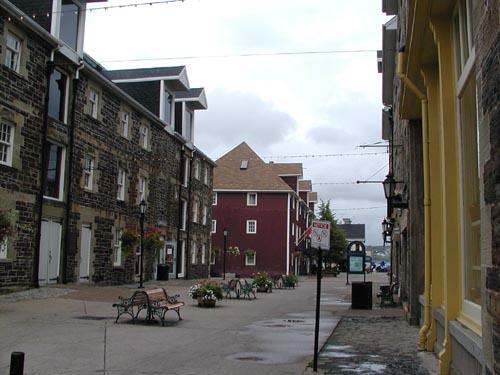
©Parks Canada Agency / Agence Parcs Canada |
Halifax Waterfront Buildings National Historic Site of Canada
Halifax, Nova Scotia
The Halifax Waterfront Buildings NHSC comprises a group of former stone
and wooden warehouses on the waterfront that have been rehabilitated to
serve a variety of commercial purposes including offices, shops and
restaurants.
The Halifax Waterfront Buildings were designated a National Historic
Site of Canada because the site is the most significant
pre-Confederation complex of maritime commercial buildings in
Canada.
The heritage value of this site resides in the tight grouping of
warehouse-type buildings on the waterfront, in their informal,
functionally driven designs, and in their relatively heavy and unadorned
construction materials and techniques. Construction of this group of
buildings began in the early 19th century and proceeded through the
century in an ad hoc process of construction, alteration and addition as
needs dictated. The number of buildings, their considerable size and
durable construction materials speak to the mercantile wealth that
supported Haligonian society during the 19th century. The rehabilitation
of the buildings in 1972-1973 returned their exteriors to an
approximation of their appearance circa 1900, while developing their
interiors for new commercial uses and sanitizing their immediate
surroundings.
|
|
Halifax WWII Coastal Defences National Historic Site of Canada
Halifax, Nova Scotia
During the Second World War the Royal Canadian Navy and the Royal
Canadian Air Force protected shipping on vital North Atlantic routes
which were the lifeline of the Allies. Army units shared in the defence
of the seaports which were essential to that shipping. In the face of a
determined campaign by German submarines and despite heavy losses, the
Atlantic routes were kept open. Canada's most heavily defended port,
Halifax served as the main convoy assembly point for outbound traffic
and played a key role in furthering the delivery of desperately needed
wartime materiel.
|

©Parks Canada Agency / Agence Parcs Canada, 2006 |
Henry House National Historic Site of Canada
Halifax, Nova Scotia
Henry House National Historic Site of Canada is a two-and-a-half-storey
stone house built in the early 19th century. Located at the front edge
of its lot on the edge of downtown Halifax, Henry House features a gable
roof topped by a single side chimney, a portico-covered side entrance,
various multi-pane sash windows, and walls of ashlar granite blocks on
the façade and dressed rough ironstone on the gable ends.
In its side hall plan and its granite and ironstone exterior, Henry
House is representative of the style of early 19th-century British North
American residences built for the elite. In favour of uniting the
British North American provinces, and one of five delegates appointed to
represent Nova Scotia at the Charlottetown Conference, William A. Henry
made this house his residence during the time of Confederation.
|

©Canadian Register of Historic Places, 2006 |
HMCS Sackville National Historic Site of Canada
Halifax, Nova Scotia
HMCS Sackville National Historic Site of Canada is a Canadian
built, Flower Class Corvette currently berthed at a wharf in downtown
Halifax, Nova Scotia. She is an armed, steam-powered ship with a single
propeller. These small, warships were used as convoy escort vessels by
the allies during the Second World War.
HMCS Sackville is one of the last Flower Class Corvettes known to
exist. Designed for mass production in small shipyards, they were based
on a British Admiralty design patterned after a whale-catcher. This
class of ship played a major role in the Battle of the Atlantic. In
December 1941, HMCS Sackville entered service escorting convoys
between Newfoundland and Northern Ireland. On the night of August 3-4,
1942, while escorting an eastbound convoy in thick fog, HMCS Sackville
engaged three German U-boats. Lieutenant Alan Easton and his crew
seriously damaged one submarine, hit another with gunfire, and depth
charged a third. This action won the Distinguished Service Cross (DSC)
for Lieutenant Easton and commendations for the crew. After seeing
action again in September 1943, HMCS Sackville was redeployed as an
officer training ship in 1944, and laid up in reserve in 1945.
Recommissioned in 1952 HMCS Sackville then spent the following 30 years
supporting oceanographic, hydrographic, and fisheries research. The ship
retired from the Royal Canadian Navy in 1982 and was transferred to the
Canadian Naval Corvette Trust in 1983. Now restored to her 1944
configuration, HMCS Sackville is open to the public.
|

©Parks Canada Agency / Agence Parcs Canada, 1993 |
Hydrostone District National Historic Site of Canada
Halifax, Nova Scotia
This English-style garden suburb, one block deep and ten blocks wide, is
located in the north end of Halifax. On its short orthogonal streets are
homogeneous terrace-type houses arranged to face wide, park-like courts.
At the Young Street boundary is a small commercial row, designed in the
same subdued Tudor Revival style as the residential area.
Hydrostone district was designated a national historic site of Canada
because it is an excellent example of the English-style garden suburb in
Canada retaining a high degree of authenticity. Its series of
rectangular treed courtyards lined on both sides with a repetitive
repertoire of residential 'Hydro-stone' buildings creates a remarkable
sense of time and place with notably few jarring or intrusive elements,
and it is the nation's first public housing project and an important
example of the work of the influential town planner Thomas
Adams.
Built to replace housing destroyed by the Halifax Explosion of 1917, the
concrete-block (Hydro-stone) buildings were designed by Ross and
Macdonald to complement Thomas Adams' plan.
|
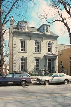
©Parks Canada Agency / Agence Parcs Canada |
Jonathan McCully House National Historic Site of Canada
Halifax, Nova Scotia
The Jonathan McCully House is an elegant two-and-a-half storey
Italianate-style, stuccoed townhouse on a narrow urban lot in downtown
Halifax, Nova Scotia.
Jonathan McCully House was designated a national historic site of Canada
because: between 1863 and his death there on 2 January 1877, it was the
residence of Jonathan McCully (1809-1877), Father of Confederation and
person of national historic significance; and it is a remarkably intact
example of a mid-19th century town house, and an important artifact of
urban life in the pre-Confederation era.
The heritage value of this site resides in its historical associations
with Jonathan McCully and in those physical elements that carry its
conservative Italianate design and illustrate an upper middle-class
urban townhouse of the mid-nineteenth century. Built in the late 1850s,
the building was carefully restored in the 1990s.
|
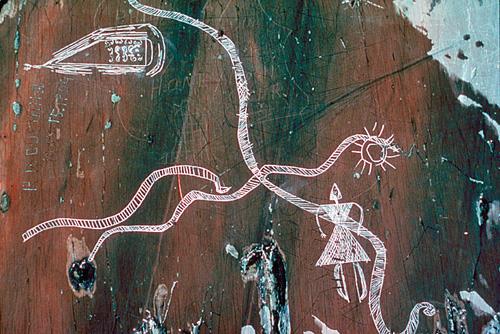
©Parks Canada Agency / Agence Parcs Canada |
Kejimkujik National Historic Site of Canada
Kejimkujik National Park of Canada, Nova Scotia
Important Mi'kmaq cultural landscape.
Kejimkujik National Historic Site of Canada is a protected area in the
centre of the broader Mi'kmaq cultural landscape of Kespukwitk, one of
the seven traditional districts of the Mi'kmaq. It encompasses 404
square kilometres of land and water in central south-western Nova
Scotia's Kejimkujik National Park of Canada. It is a cultural landscape
associated with the Mi'kmaq people, and incorporates 38 aboriginal
sites, four petroglyph sites, three villages and a cemetery.
The heritage value of Kejimkujik lies in its broad range of cultural
features, which serve as a testament to, and record of, the long-term
relationship between the Mi'kmaq and the natural environment of their
land.
|
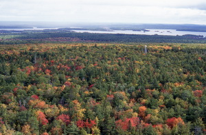
©Parks Canada Agency / Agence Parcs Canada |
Kejimkujik National Park of Canada
Headquarters: Annapolis County, Nova Scotia
Nova Scotia's inland of historic canoe routes and portages.
A world of natural and cultural wonders awaits you at Kejimkujik
National Park and National Historic Site, the only Parks Canada site
which is designated both a National Park and a National Historic
Site.
Nature is at its best in Kejimkujik. Camp in a beautiful wooded campsite
or remote wilderness site and listen for the call of the loon. Discover
historic canoe routes, experience Mi'kmaw petroglyphs, and swim in the
warm waters of Kejimkujik Lake. Don't forget about Kejimkujik Seaside.
Turquoise waters, white sand and seals basking on nearby rocks will
captivate you.
|
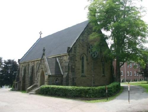
©Parks Canada Agency / Agence Parcs Canada, 2007

©Parks Canada Agency / Agence Parcs Canada, 2007

©Parks Canada Agency / Agence Parcs Canada, 2007 |
King's College National Historic Site of Canada
Windsor, Nova Scotia
King's College National Historic Site of Canada is located south of the
Avon River in Windsor, Nova Scotia. The location was chosen because it
was situated away from the distractions of major cities, and because
many influential Nova Scotians owned homes in the surrounding area. The
site designated as King's College in 1923 is still an educational
facility today, and consists of King's-Edgehill School and a number of
landscape features, early educational buildings, staff buildings and
student residences. These include Alexandra Hall, Hensley Memorial
Chapel, Convocation Hall, Buckle House, and Marshall House.
The University of King's College was founded by Reverend Charles Inglis,
the first Bishop of Nova Scotia, and other Anglican United Empire
Loyalists in Windsor, Nova Scotia, in 1789. King's was the first
university to be established in Britain's overseas Dominions. There was
significant anxiety in the colony about education following the American
Revolution. While there were several universities in New York, New
England and other American states, there were no institutions for higher
education in the remaining British colonies. King's College was
established to prevent young men from becoming alienated and traveling
abroad to receive an education. In 1802, King's College received a Royal
Charter from King George III. Graduates of the university attained
positions of prominence in the ministry, in law, in the army, in
political life and in the literary world. Since its foundation, the
College has also been the primary educational institution for members of
the clergy in the Maritime Provinces.
Constructed between 1861 and 1863, Convocation Hall is the oldest
surviving building on the original campus of King's College. It is
situated in an isolated location so as to remain protected from the
threat of fire. Convocation Hall was used as the museum and library at
King's College from the time of its completion in 1863 until 1923, when
the college moved to Halifax.
|

©Tourism, Culture and Heritage, Province of NS/Province de N-É, 2004 |
Knaut-Rhuland House National Historic Site of Canada
Lunenburg, Nova Scotia
Located in the centre of downtown Lunenburg, the Knaut-Rhuland House
National Historic Site of Canada, is a severely formal wood frame house
of classical inspiration. Built flush to the street, this vernacular
clapboard home is given an air of grandeur by the split staircase
accessing the central entry.
This attractive house, built around 1793, is one of the best early
examples of British classicism embodied in a residence in Canada. Its
balanced proportions and formal decorative detailing are a precursor of
more elaborate homes designed in later decades. The centre-hall plan and
classical motifs of the interior reflect the harmony of the exterior.
The building is named for its first two owners, merchant Benjamin Knaut
and mariner Conrad Rhuland. Minor modifications over the years adjusted
the layout according to contemporary needs, including its brief
subdivision into two apartments. Save for the addition of modern wiring
and plumbing, these changes were reversed in the 1980s and the house is
now operated as a historic site, open to the public.
|
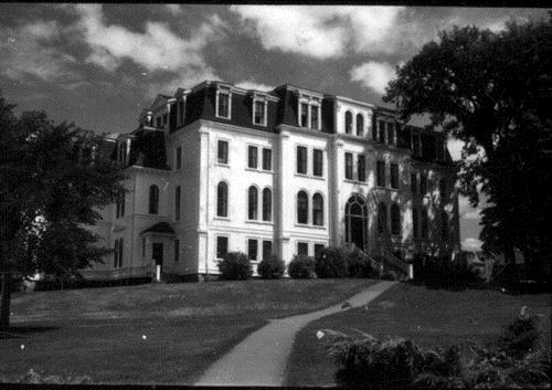
©Parks Canada Agency / Agence Parcs Canada, 1970 |
Ladies' Seminary National Historic Site of Canada
Wolfville, Nova Scotia
Ladies' Seminary National Historic Site of Canada, also known as
Seminary House, is located at the centre of the Acadia University campus
in Wolfville, Nova Scotia. The site consists of an L-shaped,
three-and-a-half storey, Second Empire style-building with a high
mansard roof punctuated by gables, dormers and slightly projecting
façades. Erected in 1878, the Ladies' Seminary is the country's oldest
facility associated with the upper-level training of women. Until 1914,
when a women's-only university residence was opened, it was the home of
all females attending Acadia University.
The Ladies' Seminary, now called Seminary House, exemplifies a key stage
in the equal treatment of women in Canada, and their admittance to a
university-level education. Opened in 1878, the building served as a
home for females attending Acadia University between 1881, when they
were first admitted to post-secondary programs, and 1914, when a
separate women's residence was opened. The Ladies' Seminary was
initially constructed to house the university's affiliated women's
secondary school, the Acadia Ladies' Seminary, and to accommodate
certain programs - such as art and music - which, at Acadia, were
identified as distinctly "female" programs. The Seminary also offers
specific structural evidence of this pioneer phase of female education.
For example, this theme is expressed in the placement of the facility on
the campus, in the quality of the external and interior design, and in
the nature of the facilities included within the building. These three
elements help to interpret the distinctive quality of post-secondary
education for women in Canada during the final quarter of the 19th
century.
In 19th-century campus planning, location and visual prominence exactly
reflected traditional societal roles of the times. As such, the Ladies'
Seminary was purposefully placed in a secondary position, behind and to
the south of the main college building. It was largely hidden from
public view by trees, providing graphic evidence of contemporary views
of the relative importance of education for men and women. Furthermore,
the seminary used a domestically-scaled version of the Second Empire
style for its exterior design; a choice that melded the building's
function as both domestic and official architecture. Instead of the main
university building's combination of convocation hall, classrooms and
offices, the seminary's centre-hall plan provided a dining room, kitchen
and laundry on the ground floor; reception rooms, a music room, nine
bedrooms and six parlours on the second floor; and two identical upper
floors, each featuring twelve bedrooms, seven parlours and three music
rooms.
|

©Parks Canada Agency / Agence Parcs Canada, 1965 |
Little Dutch (Deutsch) Church National Historic Site of Canada
Halifax, Nova Scotia
Located in Halifax's north end, the Little Dutch (Deutsch) Church
National Historic Site of Canada stands within an evocative 18th-century
burying ground, surrounded by a stone wall. This modestly sized wooden
structure is a remnant of the city's early years and features a simple
rectangular plan, a gable roof and spired tower that stands in contrast
to the surrounding 19th-century mansions and 20th-century
highrises.
The Little Dutch (Deutsch) Church is located on a pre-existing burying
ground which had been set aside in 1752 for the recently arrived
German-speaking immigrants who formed a cohesive community based on
their shared language and faith. The group acquired a building in 1756
that was moved to these burial grounds and adapted for its present. By
1758, the interior was finished by parishioners under the direction of
joiner Christopher Cleestattel. In 1760, the church was extended to the
north to support a belltower housing a bell taken from Louisbourg. The
burial ground continued in use throughout most of the 19th century.
Stone walls were erected around its perimeter in 1919.
While offering Lutheran services, the church was officially part of St.
George's Anglican parish and, with the inflow of more English-speaking
settlers into the area and the construction of St. George's round church
in 1800, the religious role of the little church diminished. It
continued to serve the German-speaking community as a school and social
centre into the 19th century. While undergoing occasional repair and
renovation, it has remained essentially intact.
|
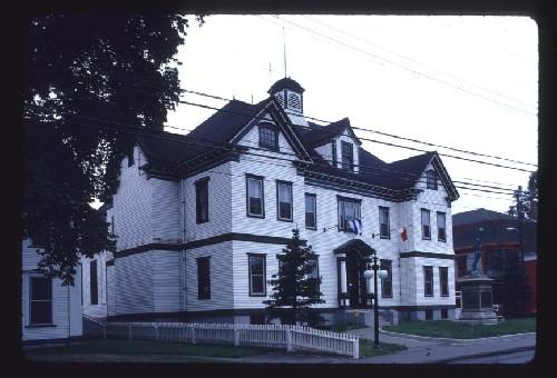
©Parks Canada Agency / Agence Parcs Canada, 1984 |
Liverpool Town Hall National Historic Site of Canada
Queens, Nova Scotia
The Liverpool Town Hall National Historic Site of Canada is a large
building constructed of wood in a Classical Revival style. It comprises
a central two-and-a-half-storey rectangular block with rear extensions.
Now serving as a museum and theatre, the former town hall is located on
Main Street in Liverpool, Nova Scotia and is set back far enough from
the street to sustain a war memorial and a flag pole in front.
The heritage value of this site resides in its historical associations
with the town of Liverpool as illustrated by its site, setting, design,
form and materials. The Liverpool Town Hall was designed to accommodate
a range of community functions including civic offices but also the
community library, the registry of deeds for Queens County, and an opera
house. Its size and formal design reflected Liverpool's continuing
importance as a commercial centre at the turn of the century. The
building is distinguished by its classically inspired decoration and
proportions and by its wooden construction, which was a rare feature on
town halls of this scale built during the 20th century.
|
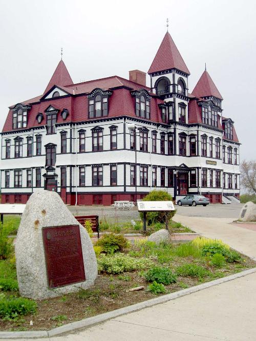
©Parks Canada Agency / Agence Parcs Canada |
Lunenburg Academy National Historic Site of Canada
Lunenburg, Nova Scotia
Lunenburg Academy is a large, late 19th century school building in
Lunenburg, Nova Scotia. It is a three-storey, wooden building in the
Second Empire style, surrounded by a spacious, open playground area. Its
key location atop Gallows Hill is visible from most viewpoints when
approaching Lunenburg. The property abuts Old Town Lunenburg Historic
District National Historic Site of Canada.
Lunenburg Academy illustrates a significant stage in the evolution of
the education system in 19th century Nova Scotia, which had developed
from one-room schoolhouses into the Academy system. The county academies
were publicly funded and offered high quality secondary education within
the public school system. This was reflected in their design, curriculum
and quality of teachers and facilities. The Lunenburg Academy was
constructed between 1894-1895 to the designs of prominent local
architect Harry H. Mott.
|

©Parks Canada Agency / Agence Parcs Canada |
Marconi National Historic Site of Canada
Table Head, Nova Scotia
Site of first wireless station in Canada.
This national historic site of Canada honours Marconi's role in the
development of today's network of global communications. In 1902, the
first official wireless message was sent from this site across the
Atlantic Ocean to England. Visitors can see the Wireless Hall of Fame
and walk the interpretive trail to the original transmission
station.
The Marconi National Historic Site of Canada marks the isolated site
where Guglielmo Marconi received the first transatlantic telegraph
message in Table Head, Cape Breton Regional Municipality, Nova Scotia.
It is situated on a plateau above high cliffs overlooking the Atlantic
Ocean, and contains the remains of two telegraph towers that once
supported Marconi's antennae and the foundation walls of his receiving
room and powerhouse.
The heritage value of the Marconi National Historic Site of Canada lies
in its historical association with the work of Guglielmo Marconi as
illustrated by the surviving cultural landscape. This value resides in
the setting and disposition of the site and in the archaeological
remains of Marconi's activity contained within the site.
Guglielmo Marconi used this site as his first commercial research and
transmission facility during the years 1902-1904 before moving his
headquarters to a new location. He received and sent the first exchange
of radio messages across the Atlantic at this location. The station
constructed in 1902 consisted of four towers 64 metres high, set in a
square-shaped 64 metre square piece of land, which together supported an
antenna of copper wires in the shape of an inverted pyramid. An
operating room and powerhouse were constructed in the middle of the
square with a residence for senior staff at the south end of the site.
These facilities were dismantled and moved to a larger site between
Glace Bay and Port Morien, in 1904.
|
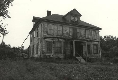
©Parks Canada Agency / Agence Parcs Canada, Aynsley MacFarlane |
Marconi Wireless Station National Historic Site of Canada
Cape Breton Regional Municipality, Nova Scotia
The Marconi Wireless Station National Historic Site of Canada is located
on Nova Scotia's rugged northeast coastline, between Glace Bay and Port
Morien, in Cape Breton Regional Municipality. Consisting of 350 hectares
(800 acres) of mostly barren headland, the site was the location of the
first regular intercontinental wireless communications service.
Marconi Wireless Station, operating with a "sister" station in Clifden,
Ireland, was the first to provide regular public intercontinental
service in 1908. Built between 1905 and 1907, it became the main
transmitting station and the site where Marconi further refined wireless
technology.
The site provided an alternative to the first permanent station, which
proved too restricted. The original site was established in 1902 at
Table Head, on Cape Breton Island, by Guglielmo Marconi after the
feasibility of transatlantic wireless communication was demonstrated in
1901. Located further south, between Glace Bay and Port Morien, the
Marconi Wireless Station ceased operations in 1946.
|
©Parks Canada Agency / Agence Parcs Canada, S. Quon, 2001 |
Melanson Settlement National Historic Site of Canada
Lower Granville, Nova Scotia
Pre-expulsion Acadian farm community, 1664-1755.
Melanson Settlement contains the archaeological remains of a
pre-Deportation Acadian community (c. 1664-1755). These archaeological
resources reflect the family communities settled by Acadians and
Acadians' unique dykeland agriculture practised along the Annapolis
River (formerly the Dauphin River).
Melanson Settlement National Historic Site of Canada is the upland
village fragment of a 17th- and 18th-century Acadian family farming
settlement along the Annapolis River. It consists of a dyked terrace
with subsurface archaeological remains, situated in the salt marshes of
the Annapolis River.
The Melanson Settlement was designated a national historic site of
Canada in 1986 because its in-situ resources reflect the family
communities in which the Acadians settled along the Dauphin (now
Annapolis) River and undertook a form of agriculture unique in North
America.
The heritage value of this site resides in its sense of place - the
immediate visual link between its geographic properties and life in this
location in Acadian times, and the clarity and comprehensiveness of the
view imparted as well as in its in-situ resources from the Acadian
period.
The settlement was established on the lower Annapolis River by Charles
Melanson and Marie Dugas after their marriage in 1664. It was
subsequently occupied by four generations of their family before the
Acadian Deportation of 1755. Historically it consisted of the family
village on an upland terrace, with cultivated fields on the vast
adjacent dyked salt marshes.
|

©Halifax Regional Municipality / Region Municipal de Halifax, 2007 |
Memorial Tower National Historic Site of Canada
Halifax, Nova Scotia
Memorial Tower National Historic Site of Canada is dramatically located
on a rise of land in Sir Sandford Fleming Park overlooking downtown
Halifax, Nova Scotia. Standing 34 metres in height, the imposing tower
is approached by a large staircase and is flanked by two large bronze
lions. The base of the tower is constructed of rough grey ironstone
while the upper storey is of grey granite and features Palladian
windows.
The Memorial Tower was built in 1908 to commemorate the adoption of
representative government in Nova Scotia (1758), the first British
colony to do so. The monolithic base of the tower and the Palladian
windows of the upper storey illustrate the use of High Victorian and
Edwardian Classical styles respectively, and gives the tower its unique
appearance. This combination of design styles captures this transitional
moment in the meaning of Canadian nationalism as it moved toward a more
independent relationship with the British Empire prior to the First
World War.
|

©The Canadian Mining Manual, 1896 |
Nova Scotia Coal Fields (Stellarton) National Historic Site of Canada
Stellarton, Nova Scotia
|

©NAC, PC 29313, c.1914 |
Nova Scotia Coal Fields (Sydney) National Historic Site of Canada
Sydney, Nova Scotia
Surviving clusters of in situ resources associated with the fields and the coal industry
|
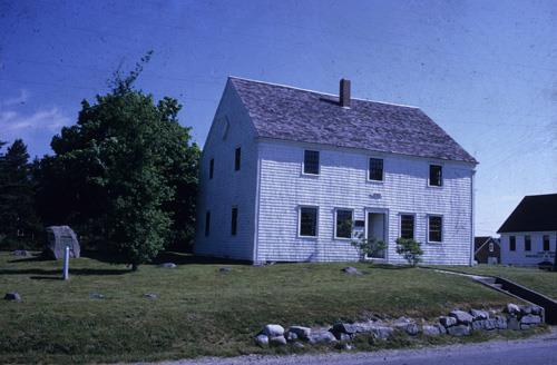
©Parks Canada Agency / Agence Parcs Canada |
Old Barrington Meeting House National Historic Site of Canada
Barrington Head, Nova Scotia
Old Barrington Meeting House National Historic Site of Canada is an
exceptional surviving example of the type of meeting house erected
throughout New England and Atlantic Canada in the late 18th and early
19th centuries. Located in Barrington, Nova Scotia, this building
combines religious with civic functions. It is a very simple but
beautifully constructed wood frame structure, designed in the vernacular
classicism of the era. Although modified over the years, it retains a
high degree of integrity.
Erected in 1765 by settlers from New England, this meeting house served
as the civic and religious centre for Barrington Township for almost a
century, accommodating all Christian denominations. Its function was
confined to religious activities until it was preserved as a museum in
the late 20th century. Both its exterior, covered with clapboard, and
its interior, with a pulpit facing the central door and surrounded on
three sides by pews and an upper Gallery, imitate meeting houses found
throughout New England. Its plain appearance was an intentional
reflection of the Puritan rejections of worldly ostentation.
|

©Parks Canada Agency / Agence Parcs Canada, 1993

©Parks Canada Agency / Agence Parcs Canada, 1993 |
Old Burying Ground National Historic Site of Canada
Halifax, Nova Scotia
The Old Burying Ground National Historic Site of Canada in Halifax, Nova
Scotia, contains more than 1,200 head and foot stones, constituting a
unique Canadian concentration of gravestone art from the 18th and early
19th centuries. This early graveyard is a 0.91 hectare treed rectangle
separated on all sides from its urban environment by a stone wall
bearing a decorative iron fence. On its south end, a substantial
monument to the Crimean War faces Barrington Street. The burying ground
now serves as a significant urban green space.
The heritage value of this site resides in the "extra muros" location,
the extent, layout and materials of the burying ground and in the rich
variety of styles, poignant images and carving skills displayed on its
extensive collection of grave markers. Used by various Christian
denominations, the Old Burying Ground originally was managed by St.
Paul's Anglican Church, serving the city of Halifax from 1749 until its
closure in 1844. The Welsford-Parker Memorial to two Haligonians' heroic
service in the Crimean War was erected at its entry in 1860 when the
grounds were also fenced and landscaped.
|

©Parks Canada Agency / Agence Parcs Canada, C. Reardon, 1995 |
Old Town Lunenburg Historic District National Historic Site of Canada
Lunenburg, Nova Scotia
The Old Town Lunenburg Historic District covers the core area of the
town of Lunenburg, a well-preserved example of 18th-century colonization
and settlement patterns with numerous outstanding examples of vernacular
architecture spanning more than 240 years. It occupies the side of a
hill and a narrow area along a natural harbour and includes the town's
original parade square, as well as a waterfront area that is associated
with the fishing and shipbuilding industries. Old Town Lunenburg has
also been designated a World Heritage Site.
The Old Town Lunenburg Historic District was designated a national
historic site in 1991 by virtue of its gridiron layout, one of the
earliest and most intact British model plans in Canada, its strong
historical associations especially with the Atlantic fisheries, and the
richness and homogeneity of its architecture.
The heritage value of the Old Town Lunenburg Historic District resides
in the original plan, the built forms and open spaces within the plan,
the physical and cultural manifestations of the off-shore fishing and
shipbuilding industries and the harmonious integration of the town and
the seascape. Laid out by Charles Morris at the time of his landing on
June 8, 1753, Lunenburg's Old Town Plan was the second British model
plan created in present-day Canada, a gridiron plan type which had a
direct and important relationship to British imperial settlement
policy.
|
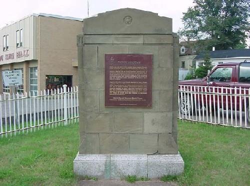
©Parks Canada Agency / Agence Parcs Canada, 2007 |
Pictou Academy National Historic Site of Canada
Pictou, Nova Scotia
Pictou Academy National Historic Site of Canada, of which there are no
extant remains, is marked by a Historic Sites and Monuments Board of
Canada plaque on a cairn located on the corner of Church Street and
Willow Street in Pictou, Nova Scotia. A pathway leads to the monument,
enclosed by an iron fence, located on the southeast corner of the
property.
In 1803, Thomas McCulloch, a Presbyterian minister, stopped over in
Pictou on his way to Prince Edward Island due to inclement weather. He
was persuaded to stay there and become the local Scottish congregation's
pastor. In a bid to establish a school for the Scottish community,
McCulloch set up a grammar school and (in 1816) founded Pictou Academy.
During the 1820s, McCulloch fought for provincial endowment of the
Academy as a degree-granting institution and for public support of all
educational institutions. Finally, in 1831, the Academy received a
permanent endowment from the British to teach both collegiate and
grammar school subjects. From that date, Pictou Academy offered
classical and scientific education, though collegiate subjects were
eventually abandoned. In 1880, the Pictou Academy was moved to a larger
building, and the original building served as the West End School until
its demolition in 1932. Alumni of Pictou Academy included various
prominent Canadian professionals and businessmen.
|

©Parks Canada Agency / Agence Parcs Canada, 1985 |
Pictou Railway Station (Intercolonial) National Historic Site of Canada
Pictou, Nova Scotia
The Pictou Railway Station (Intercolonial) National Historic Site of
Canada is a former passenger terminal located in the town of Pictou,
Nova Scotia. It is a rectangular, two-storey brick building displaying
elements of the Chateau style. Detailing includes ornate stonework,
Elizabethan gables and a Palladian window in the main bay. A projecting
canopy runs the length of the building on both the platform and
street-facing elevations.
Pictou Railway Station was designated a national historic site of Canada
in 1976 because it is a company designed station, built in 1904, to
replace the 1867 terminus that was built for the Intercolonial Railway,
a government line, which forged a link between the Maritime provinces
and central Canada.
Pictou Railway Station is associated with the early 20th century
expansion and updating of the Intercolonial Railway prior to its
incorporation into the Canadian National Railways. The period was one of
growth and prosperity for the Intercolonial Railway reflecting a general
economic upturn and increased government budgets. The Pictou line
serviced the Pictou port facilities, which contained the railhead for
traffic bound for Prince Edward Island. Passenger service was
discontinued in 1963. The former Pictou Station suffered fire damage in
1996 that has since been repaired. The ground floor now houses a museum,
a youth centre and community activity offices.
The heritage value of this site resides in those elements of the
building that illustrate its original construction as a "Class One"
Intercolonial Railway terminal, notably the surviving design, materials
and decoration.
|

©Pier 21, Jennyrotten, 2010 |
Pier 21 National Historic Site of Canada
Halifax, Nova Scotia
Pier 21 National Historic Site of Canada is part of the immense Ocean
Terminals passenger landing quay situated at Piers 20-22 in Halifax
Harbour off the city-side street of Terminal Road. It includes the
transit shed on Pier 21, which together with the brick Central Bay
Office separating Piers 21 and 22, constitutes the centre section of the
integrated Ocean Terminals transit building, and serves as the
facility's entrance pavilion. Pier 21 is located on the north edge of
the wharves and piers that constitute the public Port of Halifax, just
behind the Nova Scotian Hotel and the VIA Rail station to which it is
historically linked. Pier 21 is now operated as an immigration
museum.
The heritage value of Pier 21 National Historic Site of Canada lies in
its association with the mid 20th-century immigration experience and its
illustration of the type of building designed to accommodate the
processing of immigrants during that time period. Pier 21 was
constructed in 1928 to provide new integrated passenger landing quays
for the Port of Halifax. Much of it was destroyed by fire and rebuilt in
1944. Its new facilities reflected a new mid-20th century streamlining
of the immigration process. From 1945-1960 it witnessed the massive
stream of post World War II European immigration to Canada, including
the arrival of the war brides, an event of national historical
significance commemorated by a plaque at this location. Pier 21 closed
its doors in 1971 and since has been rehabilitated by the Pier 21
Society as a museum to immigration.
|

©Parks Canada Agency / Agence Parcs Canada, J.P. Jérôme, 1991 |
Port-Royal National Historic Site of Canada
Port Royal, Nova Scotia
Reconstruction of 1605 French settlement.
This national historic site features a reconstruction of early 17th-
century buildings representing the former colony of the French who
settled for a time along the Nova Scotia coast. Costumed interpreters
and period demonstrations help recreate the look and feel of Port-Royal,
one of the earliest settlements in North America. Visitors can also take
in the panoramic view of the Annapolis River and Basin.
Port-Royal National Historic Site of Canada consists of a group of
wooden buildings within a stockade, erected as a historic reconstruction
of an early 17th-century French fort. The habitation is located on the
north shore of the Annapolis Basin opposite Goat Island.
The heritage value of Port-Royal National Historic Site resides in the
reconstructed buildings as an illustration of an early attempt at French
colonization and as an example of an early twentieth-century approach to
heritage conservation. Port-Royal National Historic Site was constructed
in 1939.
|

©Parks Canada Agency / Agence Parcs Canada, 1993

©Parks Canada Agency / Agence Parcs Canada |
Prince of Wales Tower National Historic Site of Canada
Halifax, Nova Scotia
Late 18th-century stone defence tower, 1796-99.
Built in 1796-97 to protect British batteries from French attack, the
Prince of Wales Tower was the first tower of its type in North America.
Exhibits portray the tower's history, architectural features and
significance as a defensive structure.
This National Historic Site of Canada is part of the Halifax Defence
Complex.
Prince of Wales Tower National Historic Site of Canada is a large, round
stone defensive tower located in Point Pleasant Park, Halifax, Nova
Scotia.
The heritage value of Prince of Wales Tower lies in the legibility as a
specific type of defensive structure, and in its siting and relationship
with other 18th -20th century elements in the shore defence facilities
of Halifax harbour. It was built by the British government on the order
of Edward, Prince of Wales (1796-1799) to defend the sea batteries at
Point Pleasant. The tower ceased to be used for military purposes in the
19th century and was transferred to National Parks and Historic Sites in
1936. It was declared a National Historic Site in 1943, and restored and
opened for visitation in 1978.
|

©Province House, Jimmy Emerson, 2010 |
Province House National Historic Site of Canada
Halifax, Nova Scotia
Province House National Historic Site of Canada is a grand, three-story
sandstone public building located on an enclose landscape ground
containing a garden and monuments, within the historic heart of Halifax,
Nova Scotia. Built from 1811 to 1819, as the seat of government for Nova
Scotia, it is one of the finest Palladian-style buildings in Canada. Its
symmetrical composition, harmonious proportions and refined interior
detailing are distinguishing features of the classical architecture of
Georgian England. The building continues to serve as the legislative
seat for the Province of Nova Scotia.
As Canada's oldest legislative seat, Province House has witnessed
important political and legal debates, including newspaper editor Joseph
Howe's defence against charges of libel, which led to the creation of
the freedom of the press, and the winning of responsible government.
Designed by architect John Merrick much of the detailed interpretation
of the Palladian-inspired plans was realized by master builder Richard
Scott. A stone Royal coat of arms carved by David Kinnear was placed
above the main entry in 1819. Architect Henry F. Busch remodelled the
original Supreme Court chambers to house the Legislative Library in
1861-1862, and additional interior rehabilitation was carried out by
Edward Elliott in 1886-1888.
Province House is a sophisticated example of the Palladian compositional
formula adapted for early 19th-century public buildings. Its rectangular
block with projecting pedimented frontispiece and side wings, the
tri-partite division of its storeys and the use of Roman Ionic order to
emphasize the importance of the main floor are organized into a
symmetrical composition of classical scale and proportion. Palladian
concepts of order extend to the interior spatial organization and to the
restrained and harmonious decorative program, culminating in the
exquisite plasterwork of the principal storey.
|

©Parks Canada Agency / Agence Parcs Canada, 2008 |
Royal Battery National Historic Site of Canada
Louisbourg, Nova Scotia
Role in the 1745 and 1758 sieges of Louisbourg.
Royal Battery National Historic Site of Canada, located within the
Fortress of Louisbourg National Historic Site of Canada in Nova Scotia,
is an archaeological site that dominates the north shore of Louisbourg
Harbour. Appearing as a low grassy ridge, the outline of the battery's
ditch and glacis are still evident, as are the mounds that mark the
remains of the flanking towers.
The Royal Battery was part of the defences of Louisbourg harbour. The
French began to build it in 1724 on the north shore of the harbour
opposite its narrow entrance. The battery was essentially complete by
1728, but additions were made over the next few years and it achieved
its final form by early 1732. Once completed, its cannons could
theoretically fire directly at enemy ships coming through the channel
and heading toward the town of Louisbourg. The battery was composed of
two faces meeting at an obtuse angle, each face pierced by 15 embrasures
for cannons. Behind the ramparts were barracks defended by a ditch, a
small covered way, and a glacis. Finally, two towers defended the flanks
of the work.
In 1745, the French abandoned the battery to the attacking colonial and
British forces, who then used some of the French guns there to fire upon
the town. Returned to the French in 1749, they disabled the battery
before surrendering it once again to the British in 1758. The British
finally destroyed it in 1760, at the same time as they were
systematically destroying all the fortifications of Louisbourg. The
town's inhabitants further dismantled the site when they used it as a
quarry for building stones. Today, the Royal Battery is an
archaeological site within the Fortress of Louisbourg National Historic
Site of Canada.
|
©Parks Canada Agency / Agence Parcs Canada, 2006 |
S.S. Acadia National Historic Site of Canada
Halifax, Nova Scotia
The S.S. Acadia National Historic Site of Canada is a steel,
purpose-built hydrographic vessel currently berthed at a wharf in
downtown Halifax, Nova Scotia. Launched in 1913, she is a steam-powered
ship with two masts, one funnel and a single propeller. She has a
riveted hull and features a straight bow and a rounded counter
stern.
Launched in 1913 to begin charting the sea route along the Hudson Bay's
west coast, the S.S. Acadia was specifically designed for hydrographic
service in northern waters, and represented a departure in construction
and design from contemporary hydrographic vessels. Known as the
"workhorse of the Canadian Hydrographic Service," the S.S. Acadia would
go on to chart the port of Churchill, the coast of Nova Scotia,
including a tidal investigation of the Bay of Fundy, the Gulf of St.
Lawrence, and would complete her career by charting the waters
surrounding Newfoundland and Labrador after it joined Confederation in
1949. By charting safe passageways for shipping in these
often-treacherous waters, she contributed to the economic development of
the regions in which she was engaged. Retired in 1969, the S.S. Acadia
had been a leader in Canadian oceanography, carrying throughout her
career the most modern navigation and survey equipment available. She is
currently part of the Maritime Museum of the Atlantic in Halifax.
|

©Parks Canada Agency / Agence Parcs Canada |
Sable Island National Park Reserve of Canada
Headquarters: Sable Island, Nova Scotia
A wild and windswept island of sand sits far out in the North Atlantic,
its iconic crescent shape emerging from the expanse of the sea. Isolated
and remote, Sable Island is one of Canada's furthest offshore
islands.
Sable Island has a long and fascinating human history which spans more
than four centuries. More than 350 vessels have been wrecked due to
rough seas, fog, and submerged sandbars surrounding the island, earning
it the title "Graveyard of the Atlantic". Canada's first life-saving
station, established in 1801, was built here. Sable Island is a
testament to survival in an unlikely environment.
|
|
Sainte-Anne / Port Dauphin National Historic Site of Canada
Englishtown, Nova Scotia
Settled, 1629, by Captain Charles Daniel, and site of an early Jesuit
mission. Selected in 1713, as a naval base and one of the principal
places in Isle Royale, named Port Dauphin and strongly fortified. Its
importance declined with the choice, 1719 of Louisbourg as the
capital.
|
©Sisters of Charity, Halifax, Congregational Archives |
Former Shubenacadie Indian Residential School National Historic Site of Canada
Shubenacadie, Nova Scotia
The former Shubenacadie Indian Residential School was built in 1928-29 in the
Sipekni'katik district of Mi'kma'ki, at the top of a small hill between Highway
2 and the Shubenacadie River overlooking the village of Shubenacadie, Nova
Scotia, and 7 kilometres from Sipekne'katik First Nation (Indian Brook). The
abandoned school building was demolished in 1986 and a factory now stands where
it used to be.
The former Shubenacadie Indian Residential School was nominated by the co-chair
of the Tripartite Culture and Heritage Working Committee of the Mi'kmaq-Nova
Scotia-Canada Tripartite Forum on behalf of Survivors of the Shubenacadie Indian
Residential School and their descendants. Parks Canada and the nominator
collaborated to identify the historic values of the former Shubenacadie Indian
Residential School. The historical report prepared for the Board was co-authored
by Parks Canada and the nominator.
Open from 1930 to 1967, it was the only Residential School in the Maritimes. It
functioned within the residential school system whereby the federal government
and certain churches and religious organizations worked together to assimilate
Indigenous children as part of a broad set of efforts to destroy Indigenous
cultures and identities and suppress Indigenous histories. It was first managed
by the Roman Catholic Archdiocese of Halifax and later the Missionary Oblates of
Marie Immaculate, and staffed by the Sisters of Charity of St. Vincent de Paul
of Halifax.
Mi'kmaw and Wolastoqkew children from Nova Scotia, Prince Edward Island, New
Brunswick, and Quebec attended Shubenacadie Indian Residential School. It is
also possible that children from other Indigenous communities were sent to this
school. They were subjected to harsh discipline; malnutrition and starvation;
poor healthcare; physical, emotional, and sexual abuse; medical experimentation;
neglect; the deliberate suppression of their cultures and languages; and loss of
life. From the earliest days of the school, students, their families, and
community leaders voiced objections, and protested everything from forced
attendance to poor conditions, mistreatment, and the inadequate quality of
schooling. Many children fought against the system by refusing to let go of
their languages and identities. Some children ran away from the school in an
effort to return home.
|

©Parks Canada Agency / Agence Parcs Canada |
Sinclair Inn / Farmer's Hotel National Historic Site of Canada
Annapolis Royal, Nova Scotia
Sinclair Inn / Farmer's Hotel National Historic Site of Canada is a
two-and-a-half storey wooden building in the commercial area of
Annapolis Royal, Nova Scotia. Its rectangular massing and symmetrically
organized façade with central pediment and main entry evoke the
classical vernacular style of many of its neighbours and belie its
earlier origins. Once known as the Farmer's Hotel, this structure
evolved with the amalgamation of at least two buildings, one dating from
the Acadian era. Stabilized in the 1980s, the building is now operated
as a museum.
The heritage value of this site resides in its illustration of building
techniques and materials dating from as early as the late 17th century
through to the 19th century. A composite of more than one original
building, the structure includes very early Acadian building techniques
as well as those of the later, newer English vernacular. Operated as an
inn for over 150 years, the business closed in 1950. The building
retains much of its original material.
|
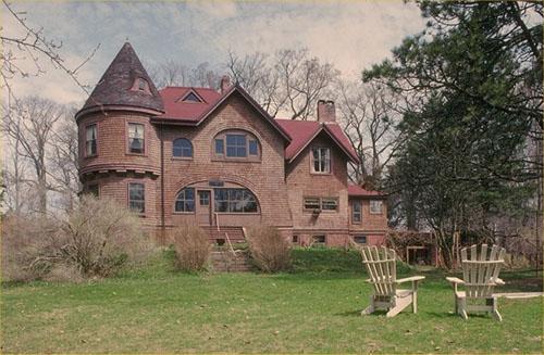
©Parks Canada Agency / Agence Parcs Canada, 1983 |
Sir Frederick Borden Residence National Historic Site of Canada
Canning, Nova Scotia
Sir Frederick Borden Residence National Historic Site of Canada is a
large, Queen Anne Revival-style house set in a park-like setting in
Canning, Nova Scotia.
The Sir Frederick Borden Residence National Historic Site of Canada was
designated in 1990 because it is a particularly good example of the
Queen Anne Revival style as expressed in domestic architecture.
The heritage value of this site resides in its material expression of
the Queen Anne Revival style, particularly in the successful aesthetic
composition of fanciful forms, asymmetrical massing and polychromatic
surfaces characteristic of its style. Entirely clad in shingle, the Sir
Frederick Borden Residence represents an American variation of the Queen
Anne Revival style, the 'shingle style', often used for domestic
buildings in the Maritime provinces.
The house was built in 1864 and renovated in the Queen Anne Revival
style in 1902 by the firm of Harris and Horton, architects (William
Critchlow Harris and William T. Horton) to serve as the home of
politician Sir Frederick Borden.
|

©Parks Canada Agency / Agence Parcs Canada |
Springhill Coal Mining National Historic Site of Canada
Springhill, Nova Scotia
Springhill Coal Mining National Historic Site of Canada is a former coal
mine located in an industrial park in Springhill, Nova Scotia. The site
consists of in situ surface and underground mining features that are
unique to Nova Scotia, including the entrances to the infamous Nos. 2
and 4 mines, a series of brick buildings, and a pond and spillway system
used for steam hoisting engines. The focal point of the site is the
one-storey redbrick building known as the lamp cabin, dating from the
early 1900s.
The heritage value of Springhill Coal Mining lies in its historical
associations with coal mining in Nova Scotia from the late-19th century
until the 1940s. Coal extraction began in Springhill in 1873, marking
the beginning of intensive coal mining in Canada. Between 1867 and 1914,
Nova Scotia was the leading producer of coal, based on the markets for
domestic and industrial fuel and post-confederation tariff protection
that encouraged the expansion of industrial activity in Nova Scotia. The
Springhill coalfields played an important role in supplying the
Maritimes, Quebec, the railways and the manufactories in the early-20th
century. The in situ mining resources located at the site represent
various coal-mining themes, including the roles of entrepreneurship,
labour and technology, and the importance of mining communities.
Safety was an issue of vital concern for the miners. A host of factors
including soft rock, the prevalence of gas, difficulty of ventilation,
restricted working spaces and the use of explosives, all contributed to
making coal mining one of Canada's most dangerous occupations. As the
workforce increased in size, large disasters began to occur in the
mines, such as the 1891 Springhill disaster in which 125 people were
killed. The sites of Nos. 2 and 4 mines would eventually become infamous
as the locations of the two great Springhill mining disasters of 1956
and 1958.
|
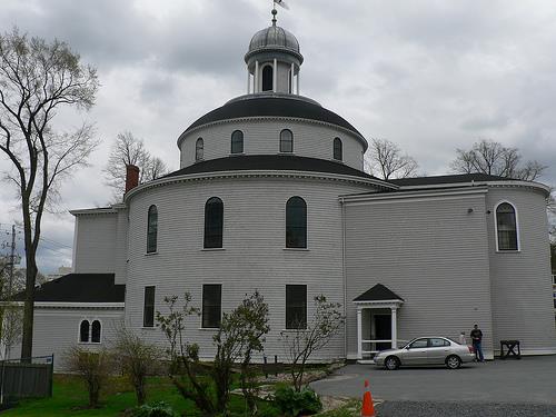
©Parks Canada Agency / Agence Parcs Canada, 1984 |
St. George's Anglican Church / Round Church National Historic Site of Canada
Halifax, Nova Scotia
St. George's is a cylindrical wooden church designed in the Palladian
style with elegantly simple openings and smooth finishes. Located in
downtown Halifax, Nova Scotia, this handsome building is associated with
the early days of the city and with its Royal linkages.
Commonly known as the 'Round Church', St. George's was begun in 1800 to
improve on the accommodations previously supplied by the 'Little Dutch
Church' nearby. St. George's is the only 19th-century example of a round
church in Canada. Reflecting a level of architectural sophistication
previously unknown in the colony, its unusual design was associated with
the Duke of Kent, who served as a military commander of Nova Scotia and
New Brunswick from 1794 to 1800. The plans have been attributed to
master shipwright William Hughes. Damaged by the Halifax explosion of
1917 and by a devastating fire in 1994, the church has been heavily
restored, but retains its classical lines and harmonious
proportions.
|
©Parks Canada Agency / Agence Parcs Canada, 1998 |
St. John's Anglican Church National Historic Site of Canada
Lunenburg, Nova Scotia
St. John's Anglican Church National Historic Site of Canada is a large,
white wooden Carpenter Gothic style church in the heart of Lunenburg,
Nova Scotia. Regarded as an important symbol of the town, it has
continually evolved over a period of some two hundred and fifty years
and, most recently, was rehabilitated after a disastrous fire in
2001.
The heritage value of this site resides in its associations with the
history of Nova Scotia and the town of Lunenburg, and in its
architecture. These values are expressed in the setting and location of
the church and those elements of its design, as well as the physical
elements that survived the fire of 2001. St. John's Anglican Church was
originally constructed 1754-1763, enlarged in 1840 and through the
1870s, and again in 1889. After a disastrous fire in 2001, the structure
was rebuilt from the surviving ruins.
|
©St. Mary's Basilica, Glenn Euloth, 2009 |
St. Mary's Basilica National Historic Site of Canada
Halifax, Nova Scotia
St. Mary's Basilica National Historic Site of Canada is a large church
prominently situated in downtown Halifax, Nova Scotia. The church's
Gothic Revival design, with impressive triple portal and tall central
spire make it one of the city's outstanding landmarks.
The heritage value of St. Mary's Basilica resides in its historical
association, particularly in its central position in the history of
Roman Catholicism in Nova Scotia as reflected in the physical and design
qualities of the church itself. One of the first Roman Catholic
cathedrals in Canada, it is an imposing example of mature Gothic Revival
architecture and its long and early history is reflected in its
architectural evolution. Begun in 1820 under Bishop Edmund Burke as the
first Roman Catholic cathedral in Nova Scotia, it heralded enormous
gains in the legal and social standing of Catholics. Under Archbishop
Thomas Connolly, a major expansion and redecoration of the church was
undertaken (1860 - 1874) to designs by Irish-American architect Patrick
C. Keely. The expansion reflected the growing confidence and importance
of the Diocese. St. Mary's was named a Basilica in 1950.
|
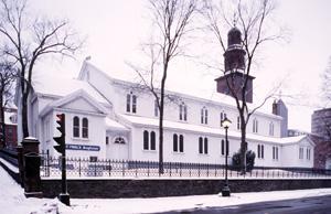
©Parks Canada Agency / Agence Parcs Canada, 1994 |
St. Paul's Anglican Church National Historic Site of Canada
Halifax, Nova Scotia
Prominently situated in front of the Grand Parade square in the historic
heart of Halifax, Nova Scotia, St. Paul's Anglican Church National
Historic Site of Canada is a small, classically-designed wooden church
with a gable roof and central steeple. Its design and splendid classical
detailing evoke its associations with the 18th-century British
establishment of the city.
Completed in 1750, St. Paul's became the cathedral church of the diocese
of Nova Scotia from 1787 until 1864 with Charles Inglis as its first
bishop. For 96 years, St. Paul's was also the official garrison church
of the local British army and navy establishment. The design of the
building probably came from a pattern book and is based on that of St.
Peter's, Vere Street, London, England, by James Gibbs. As such, St.
Paul's is an early, if evolutionary, example of the Palladian style in
Canada. Despite its 1812 expansion and the later addition of side aisles
(1868) and chancel (1873), the original wooden frame (pre-cut in Boston)
still forms the main body of the church. In 1926 the steeple was clad in
copper and the north porch rebuilt. The church was meticulously restored
in 1984-1990.
|

©Parks Canada Agency / Agence Parcs Canada |
St. Peters National Historic Site of Canada
St. Peter's, Nova Scotia
French trading post and fort, 1650-1758.
St. Peters National Historic Site of Canada is an extensive site
containing archaeological evidence of 17th- and 18th- century Mi'kmaq
and Acadian communities. It is situated on the southeastern shore of
Cape Breton, Nova Scotia, on the isthmus located between the shores of
St. Peters Bay on the Atlantic coastline, and Bras d'Or Lake. The
designated place extends along what was the Atlantic coastline in the
17th century, and crosses the isthmus within the boundaries of St Peters
Canal National Historic Site of Canada.
The heritage value of St. Peters National Historic Site of Canada lies
in its strategic location and in the evidence of early Mi'kmaq and
Acadian communities embedded there. This site underlines the strategic
long-term importance of the narrow isthmus between St. Peters Bay and
Bras d'Or Lake as a transportation route, and commemorates evidence of
the earliest settlement flanking the route, witnessing its importance as
a point of contact between the Mi'kmaq and the French, and as a French
post in the commercial rivalry between European nations in the 17th and
18th centuries.
|
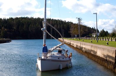
©Parks Canada Agency / Agence Parcs Canada>
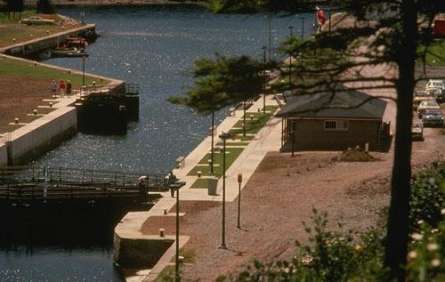
©Parks Canada Agency / Agence Parcs Canada |
St. Peters Canal National Historic Site of Canada
St. Peter's, Nova Scotia
Operational canal; structures dating from 19th-century.
St. Peters Canal is an 800 metre canal linking the Atlantic Ocean with
the Bras d'Or Lakes. Work started on the canal in 1854 and was completed
in 1869. View interpretive exhibits, enjoy a picnic lunch, or experience
the canal by pleasure craft.
St. Peter's was the site of Fort Saint-Pierre, a 17th century fortified
trading post acquired by Nicolas Denys in 1650 to trade with the
Mi'kmaq. It was also the site of Port Toulouse, a French community with
a military presence that bore witness to the Anglo-French rivalry during
the period 1713 and 1758.
St. Peter's Canal National Historic Site of Canada is a man-made water
channel that connects the Bras d'Or Lakes with St. Peter's Bay on the
Atlantic Ocean in St. Peter's, Nova Scotia together with its associated
landscape.
St. Peter's Canal was designated a national historic site of Canada
because it is part of Canada's system of canals.
The heritage value of St. Peter's Canal lies in the cultural landscape
directly associated with the construction and operation of the canal
including the land and water areas which were modified, blasted, graded
or dredged during every construction phase and stage of canal
use.
St. Peter's Canal was originally built in several phases 1854-1869, and
enlarged twice. It has been in continuous operation since its
construction as a transportation facility for commercial and industrial
goods during the 19th and early 20th centuries, and more recently for
pleasure craft.
|
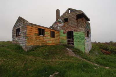
©Parks Canada Agency / Agence Parcs Canada, HRS #, 2006 |
Sydney WWII Coastal Defences National Historic Site of Canada
Sydney, Nova Scotia
During the Second World War the Royal Canadian Navy and the Royal
Canadian Air Force protected shipping on vital North Atlantic routes
which were the lifeline of the Allies. Army units shared in the defence
of the seaports which were essential to that shipping. In the face of a
determined campaign by German submarines and despite heavy losses, the
Atlantic routes were kept open. In this struggle Sydney played an
important role. It was a major convoy assembly port, protected by seven
coastal gun batteries, and included an airfield, seaplane base and
extensive dockyards.
|

©Parks Canada Agency / Agence Parcs Canada, Danielle Hamelin, 2007. |
Thinkers' Lodge National Historic Site of Canada
Pugwash, Nova Scotia
Thinkers' Lodge National Historic Site of Canada is located on a
spacious property jutting out into Northumberland Strait in the small
village of Pugwash, Nova Scotia. Thinkers' Lodge is the birthplace of
the Pugwash movement, a transnational organization for nuclear
disarmament and world peace. In 1957, at the height of the Cold War, the
first Pugwash Conference on Science and World Affairs took place here,
at the summer home of a wealthy businessman, Cyrus Eaton.
The place of Thinkers' Lodge on the world stage came out of the
intersection of a wealthy businessman and philanthropist, Cyrus Eaton,
and some of the most pressing issues of the era. Eaton purchased
Thinkers' Lodge and refurbished it as a summer inn, with the goal of
revitalizing the economy of the village of Pugwash, which had fallen on
hard times in the 1920s. A visionary philanthropist, Eaton saw the
isolated village of Pugwash as an ideal location for retreats for people
from many walks of life to escape the pressures of their everyday work
life, to relax and refocus. In the 1950s, he began organizing and
financing such gatherings with wide-ranging discussions, from the Suez
situation to nuclear disarmament.
The Pugwash Conference was held at Thinkers' Lodge in July 1957, a
meeting of scientists from both sides of the Iron Curtain that
encouraged dialogue and understanding between East and West on the uses
of nuclear power for peace and not for war. A small, but extremely
eminent group of twenty-two individuals from ten countries attended,
including three Nobel laureates, the vice-president of the Soviet
Academy of Sciences, a former director-general of the World Health
Organization and the editor of the influential Bulletin of the Atomic
Sciences. Informal aspects of the meeting, such as meals in the dining
hall and games of croquet on the grounds were just as important to the
success of the conference as the plenary sessions. The rustic and
peaceful setting of Pugwash provided an atmosphere conducive to fruitful
discussions and exchanges, marking a new willingness on the art of
scientists to engage with world affairs and social
responsibility.
|

©Parks Canada Agency / Agence Parcs Canada, 1991 |
Trinity Anglican Church National Historic Site of Canada
Digby, Nova Scotia
Trinity Anglican Church National Historic Site of Canada is a large
wooden church sited on a treed lot with a nearby cemetery in Digby, Nova
Scotia. Boldly designed, the church exhibits the functional and
structural rationalism of the Ecclesiological Gothic Revival. Its
interior disposition of spaces is clearly articulated in the exterior,
in a pyramidal building up of forms climaxing in a steep roof and
prominent spire. A surface grid pattern of wood trim around doors and
windows and across the surface expresses the wooden construction of the
building.
Designed by American architect Stephen C. Earle and built in 1878, this
church is a fine example of the Gothic Revival style as interpreted in
wood. In the spirit of British parish churches of the Middle Ages, the
exterior composition clearly defines the principal interior spaces of
nave, chancel and side aisles. The attractive pattern of vertical and
horizontal boards reflects late 19th-century American practice and is
intended to emphasize the church's frame construction. Trinity Anglican
Church replaced the original church built by Loyalist settlers on this
site in 1788.
|
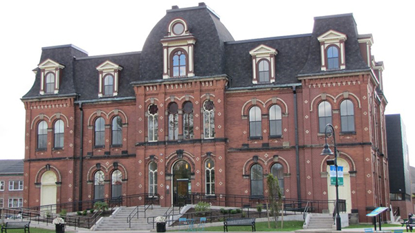
©C. Boucher, Parks Canada Agency / Agence Parcs Canada, 2017 |
Truro Old Normal College National Historic Site of Canada
Truro, Nova Scotia
A major landmark in downtown Truro, this impressive, three-storey brick
building is an excellent example of Second Empire architecture. Designed
by Nova Scotia architect Henry Frederick Busch, it features a mansard
roof, a well-proportioned central pavilion, pedimented gable dormers,
ornate brackets under its pronounced eaves, and arched windows. Built in
1877 to replace the first normal school in Truro, it was used as a
normal college until 1961. It is a testament to the movement in the
second half of the 19th century to standardize and improve teacher
training, and it is directly associated with the development of Nova
Scotia's public education system in the 19th and 20th centuries.
Truro Old Normal College is located in downtown Truro (752 Prince
Street), a town in central Nova Scotia less than 100 km northeast of
Halifax. As a "normal school," its function was the training of
teachers. It was built by the provincial department of education to
replace Truro's first normal school, an institution that had been
established in 1855 but became too small by the 1870s. The Truro normal
schools were established during a time of dramatic change in education
in British North America. Over the decades between 1840 and 1870,
governments committed unprecedented resources to the construction and
regulation of schools and put in place legislation regarding schooling.
This included the standardization and certification of teacher training.
Truro Old Normal College was used to train teachers until 1961, and for
many years it was the only college of its type in the province. After
the college closed, the building became the Truro YMCA and, later,
temporarily housed the town's municipal offices.
The Old Normal College is a very fine example of Second Empire
architecture. This imposing three-storey brick building has a raised
basement and a symmetrical, T shaped layout. Its exterior cladding is
red brick and contains contrasting geometric motifs in white brick,
which contributes to the building's uniqueness and is characteristic of
the work of its designer, architect Henry Frederick Busch. The front
façade is strongly symmetrical and features a central entry as well as
two side doors. The building also has many windows, which flood its
interior with natural light.
A recommendation to restore the old normal college was part of a 2006
redevelopment plan for the block. As a result, the building has been
renovated and expanded with the addition of a contemporary annex to
accommodate the Truro branch of the Colchester—East Hants Public
Library. The recent rehabilitation work has preserved the key
architectural characteristics of the building's exterior, while the
interior has been completely renovated to meet the current needs of the
new municipal library. Nevertheless, some of the building's significant
features have been highlighted, such as the stained glass windows, some
of the original windows, and certain mouldings. Completed in May 2016,
the new library and the redevelopment of the adjacent gardens helped the
building regain its former visibility and once again made it a landmark
in downtown Truro.
|
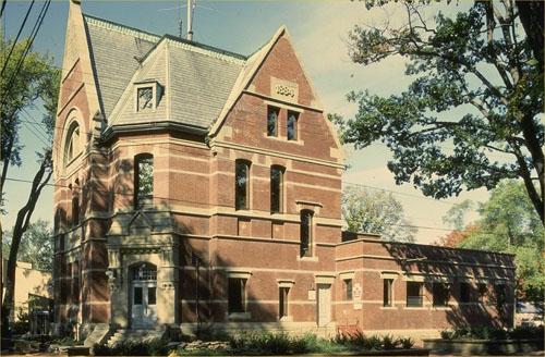
©Parks Canada Agency / Agence Parcs Canada, 1982 |
Truro Post Office National Historic Site of Canada
Truro, Nova Scotia
The Truro Post Office National Historic Site of Canada is a
two-and-a-half-storey, brick building constructed during the late 19th
century. The post office is located on a prominent corner lot in
downtown Truro.
The Truro Post Office was designated a national historic site in 1983
because: it is representative of the small urban post offices by Thomas
Fuller; it possesses architectural merit, this is to say it has not
undergone major exterior alteration; and it is in harmony with its
environment.
The Truro Post Office, built in 1883-1886, is a good example of the post
offices erected by the Department of Public Works in smaller urban
centres during Thomas Fuller's term as Chief Architect (1881-1886). It
is representative of Fuller post offices in its two-and-a-half-storey
height, its use of high-quality materials, its blend of Gothic and
Romanesque elements, and its prominent siting on a corner lot.
|
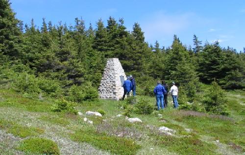
©Parks Canada Agency / Agence Parcs Canada, David Henderson, 2005 |
Wolfe's Landing National Historic Site of Canada
Kennington Cove, Nova Scotia
Successful landing led to capture of Louisbourg, 1758.
Wolfe's Landing National Historic Site of Canada is located in
Kennington Cove, on the east coast of Cape Breton Island, Nova Scotia.
Contained entirely within the Fortress of Louisbourg National Historic
Site of Canada, the site is bounded by a rocky beach to the south, and a
rolling landscape of grasses and forest to the north, east and west. It
was from this site that, during the Seven Years' War, British forces
launched their successful attack on the French forces at Louisbourg. The
site includes the cove with its two modern beaches, numerous trails, and
the Historic Sites and Monuments Board of Canada cairn.
The battle at the French Fortress of Louisbourg was one of the
definitive battles between Britain and France for dominance in North
America. Two years into the Seven Years' War, the British executed plans
to lay siege to the fortress, located on Cape Breton Island. On June
8th, 1758, Brigadier General James Wolfe, under heavy fire from French
troops, successfully landed a party of light infantry on an undefended
rocky beach in Kennington Cove, known to the French as Anse de la
Cormorandière. The successful landing allowed Wolfe and his troops to
launch a surprise attack against the French. Unaware of the size of
Wolfe's force and fearing the worst, the French troops quickly retreated
towards the Fortress of Louisbourg. While the landing of the entire
British force took weeks to complete, the initial landing of Wolfe and
his troops, and subsequent evacuation of the French forces from the
various defense works, created the opportunity for the British to lay
siege to Louisbourg. The French fortress capitulated near the end of
July 1758, effectively ending the period of French rule in Cape
Breton.
|
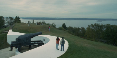
©Parks Canada Agency / Agence Parcs Canada
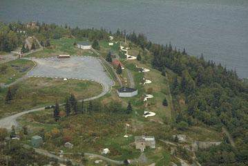
©Parks Canada Agency / Agence Parcs Canada |
York Redoubt National Historic Site of Canada
Halifax, Nova Scotia
Major seaward defences of Halifax Harbour from the American
Revolutionary War until World War II.
Established in 1793 on a bluff overlooking the harbour entrance, and
expanded in the 19th and 20th centuries, York Redoubt was a key element
in the defence of Halifax Harbour. Visit the Second World War Command
Centre, and enjoy the scenic views of the harbour mouth and adjacent
coastline. This National Historic Site of Canada is part of the Halifax
Defence Complex.
York Redoubt National Historic Site of Canada is comprised of a large,
cleared plateau on the west side of Halifax's inner harbour opposite
McNabs Island and a gun battery and searchlight positions located close
to sea level, reached by a path. The redoubt contains some 27 buildings,
related structures, and armament developed over 150 years. The upper
portion of the redoubt is located high above wooded cliffs, overlooking
the entrance to Halifax harbour which it has protected since the late
18th century.
York Redoubt was declared a national historic site for its evolving role
as part of the Halifax Defence System from the late 18th century to
World War II in protecting the principal naval stations of the British
Empire and of Canada.
The heritage value of York Redoubt lies in its physical illustration of
the historical evolution of the Halifax harbour defence system. York
Redoubt was first developed as a component of Halifax fortifications in
1793 by the British government. Major alterations to its facilities
occurred in 1794, 1812-1814, 1863-1875, 1890-1899, 1940-1943. It was
opened for visitation as a national historic site in 1968.
|
|