|
Park Summaries
Saskatchewan
All text and photos are copyrighted by Parks Canada or the Canadian Register of Historic Places
(except as noted) and were extracted from either the Parks
Canada or Canada's Historic Places
Websites. Parks with a grey background are managed by Parks Canada.

©Parks Canada Agency / Agence Parcs Canada |
Addison Sod House National Historic Site of Canada
Kindersley, Saskatchewan
The Addison Sod House National Historic Site of Canada is located in the
rural municipality of Oakdale, Saskatchewan. Set in an open, flat,
prairie environment the low one-and-a-half storey massing, inward
sloping exterior walls and the angle of the low, hipped roof combine to
give this small house a distinctive, almost pyramidal appearance.
Triangular-shaped dormers light the upper floor. Set back from the road
the house forms the centre of an original prairie homestead amongst
outbuildings surrounded by a garden and shelterbelt plantings.
Carpenter Jim Addison built Addison Sod House in 1909-1911 as the
residence for his family on his homestead. The care with which the sods
were prepared and constructed ensured that this house survived for much
longer than many others of its kind. On recognizing its durability, the
owner further developed the home, enhancing its interior layout and
finishes as well as adding a lean-to. The house is set within a grouping
of outbuildings, gardens and shelterbelt plantings typical of a prairie
farmstead from the early 20th century.
The heritage value of Addison Sod House resides in the integrity with
which this house represents a prairie "soddy", specifically its form,
construction techniques, sod brick building materials, and
setting.
|
©Parks Canada Agency / Agence Parcs Canada, 2014 |
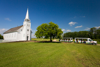
Batoche National Historic Site of Canada
Batoche, Saskatchewan
Métis village; site of 1885 Battle of Batoche; Northwest
Resistence/Rebellion
Batoche displays the remains of the village of Batoche on the banks of
the South Saskatchewan River. It was the last battlefield in the
Northwest Rebellion of 1885. Louis Riel selected Batoche as the
headquarters of his "Provisional Government of Saskatchewan". Several
buildings have been restored within the site. The site depicts the
lifestyles of the Métis of Batoche between 1860 and 1900 - the trails
they walked, their homes, their church, and the Battle of Batoche, May
9-12, 1885.
Batoche National Historic Site of Canada is located near the South
Saskatchewan River north of Saskatoon, Saskatchewan. The site, which
encompasses the vestiges of the Métis village of Batoche where the
Carlton Trail crossed the river, is dominated by a church and rectory of
the parish of St.-Antoine-de-Padoue, established by the oblates of Mary
Immaculate in the late-19th century. Batoche was also the site of the
1885 battle between forces of the Métis provisional government and those
of the Canadian government.
The heritage value of Batoche National Historic Site of Canada lies in
its historical associations with the 1885 armed conflict, the Métis
community from 1879 to the present, and the river lot land use pattern
as illustrated by the relict landscape and cultural resources surviving
as witness to those themes. The original village site was abandoned by
1920 but continued to be the centre of Métis cultural activities. After
that time, community life revolved around the parish buildings and
commercial establishments near the Caron House. River lot farming
persisted but the Métis population decreased as many left the
area.
|

©Parks Canada Agency / Agence Parcs Canada, 1989 |
Battle of Cut Knife Hill National Historic Site of Canada
Cut Knife, Saskatchewan
Battle of Cut Knife Hill National Historic Site of Canada is located on
the Poundmaker Reserve of the Cree Nation, 16 kilometres from the town
of Cut Knife Hill, near Battleford, Saskatchewan. The site of the
conflict is now marked by a plaque at the top of a steep hill surrounded
by gently rolling grassland, ravines and hills with occasional stands of
small trees. There are no visible remains of the battle during which
Canadian military forces attacked gathered camps of Cree and Assiniboine
bands before being forced to retreat. The site now contains the grave of
Chief Poundmaker, a monument to Chief Big Bear, a tepee village, and a
small interpretive museum.
In 1885 fighting erupted on the western prairies between Canadian
government forces and the Métis and First Nations peoples over land and
treaty issues. The Battle of Cut Knife Hill, as it is often referred to,
occurred after the relief of Battleford when Lt. Col. W.D. Otter and
over 300 men, accompanied by artillery, launched an attack on the
gathered bands of Cree and Assiniboine camped at Poundmaker's reserve at
Cut Knife. These bands of Cree and Assiniboine were viewed by the
government as rebels. The government troops, composed of North-West
Mounted Police, "B" Battery, "C" Company, Foot Guards, Queen's Own and
Battleford Rifles, were ranged against Cree and Assiniboine led by Chief
Poundmaker and Chief Fine Day. The surprise attack failed and the
government forces encountered a very strong defence. After six hours
fighting Otter withdrew his column in good order across a deep creek and
retreated to Battleford. On Poundmaker's orders the warriors ceased fire
and did not pursue the retreating troops. Despite prevailing in the
battle, when word came of the Métis defeat at Batoche, Chief Poundmaker
ended hostilities by surrendering at Battleford on 26 May.
|
|
Battle of Duck Lake National Historic Site of Canada
Duck Lake, Saskatchewan
The Battle of Duck Lake National Historic Site of Canada is located on a
spacious, 12-hectare grassed lot near the town of Duck Lake,
Saskatchewan. It was the site of the first battle of the North-West
Rebellion/Resistance of 1885. Located within the Beardy's and Okemasis
Reserve, the site includes an Historic Sites and Monuments Board of
Canada cairn and plaque, placed there in 1950.
The Battle of Duck Lake took place on March 26, 1885. While on the way
to confiscate guns and ammunition from Hillyard Mitchell's store near
Duck Lake, a group of North West Mounted Police and civilians
encountered a larger group of Métis, led by Gabriel Dumont. After a shot
was fired, the group of North West Mounted Police and civilians
retreated. As news of this encounter spread, Superintendent Leif N.F.
Crozier gathered 52 North West Mounted Police, as well as 43 civilians,
and they made their way along the Carlton Trail toward Duck Lake into
Chief Beardy's reserve. Chief Beardy made it clear that he wanted no
part in the upcoming skirmish, and that he did not support Riel.
Meanwhile, the group of Métis had grown to include Isidore Dumont, Louis
Riel, and Cree allies. The two groups eventually met, and the battle
began when a North West Mounted Police interpreter, fearing an ambush,
fired and killed Isidore Dumont. After 30 minutes of fighting with
casualties suffered on both sides, Crozier ordered a retreat, and Riel
ordered his followers not to shoot at them as they left.
The Battle of Duck Lake was considered a successful battle for the
Métis. The area was of strategic importance, since it controlled
Hillyard Mitchell's store and trails from Prince Albert and Fort Carlton
National Historic Site of Canada. The Rebellion/Resistance of 1885 was a
result of the issues between Métis peoples, Aboriginal peoples,
settlers, and the federal government; the Métis in particular felt that
their claims had gone unanswered, and that their future in terms of land
rights was uncertain. The Battle of Duck Lake marked the beginning of
this conflict and other significant battles would occur in the eight
months that followed.
|
©Parks Canada Agency / Agence Parcs Canada, 2008

©Parks Canada Agency / Agence Parcs Canada, 2007 |
Battle of Tourond's Coulee / Fish Creek National Historic Site of Canada
Fish Creek, Saskatchewan
Site of battle between Métis and Canadian forces, Northwest Rebellion
1885
The Battle of Tourond's Coulee / Fish Creek National Historic Site of
Canada (NHSC) commemorates the place — la coulée des Tourond — where on
April 24, 1885, Métis led by Gabriel Dumont, and Cree and Dakota First
Nations, held back the advancing North West Field Force. It was the
first time the Métis encountered the Canadian military. Greatly
outnumbered, and despite losing the element of surprise, the Métis, Cree
and Dakota stopped Middleton's progress on Batoche. Exhausted from the
day's battle, both forces withdrew from la coulée des Tourond to fight
another day. Middleton's advance on Batoche would be delayed for two
weeks. For Middleton and his mostly untested troops, time was needed to
reorganize, tend to the wounded and better prepare for a formidable
opponent. For Dumont and the Métis people, la bataille de la coulée des
Tourond was a victory that gave them time to rally Métis and First
Nations support and prepare for the defence of Batoche.
The Battle of Tourond's Coulee / Fish Creek National Historic Site of
Canada is located along the banks of Fish Creek, a tributary of the
South Saskatchewan River, 25 kilometres south of Batoche, Saskatchewan.
The site consists of a parcel of land totalling 36 hectares, including
the main battleground, Tourond's Coulee as well as archaeological
remains and landscape features associated with the battle. This location
was the site of a battle between the Métis and their allies the Cree and
Dakota from the Beardy and One Arrow First Nations, and the North West
Field Force during the 1885 North West Rebellion / Métis
Resistance.
The North West Rebellion / Métis Resistance of 1885 grew out of the
political and territorial tension that developed between the Métis
people, Aboriginal peoples, settlers, and the Canadian federal
government. The defeat of government troops by the Métis at the Battle
of Duck Lake on 26 March 1885, prompted the creation of a new army
called the North West Field Force under the command of Major-General
F.D. Middleton. On 24 April 1885, this new group encountered the Métis
and their Cree and Dakota allies at Fish Creek, beginning the first
major military engagement between these two forces.
On April 24, Gabriel Dumont led the Métis and their First Nations allies
across Fish Creek into Tourond's Coulee, with the hopes of ambushing
Middleton's troops While Dumont was outnumbered, Middleton's forces
lacked experience and training as Fish Creek was the first combat
experience for the 800 Canadian troops involved. Lacking reinforcements,
Middleton sent his troops north on both banks of the Saskatchewan River.
The Métis and their allies had planned to attack under cover of
darkness, but they were unable to locate Middleton's troops, and instead
stationed themselves in Tourond's Coulee, hidden in the ravine just off
the main trail. At approximately 9:00 a.m., the battle began with
shellfire from the North West Field Force. Though the Métis were
sheltered from the attack, the Tourond homestead was destroyed. When the
North West Field Force tried to move to a better position, they exposed
themselves to the Métis, resulting in heavy casualties. By evening, the
Métis had retreated to the east side of the coulee; many Métis had fled,
but 70 reinforcements arrived from Batoche that evening. Dumont,
acknowledging the lack of ammunition and arms, set fire to the prairie
in hopes of pushing back the militia.
Middleton withdrew his troops to a camp approximately one kilometre from
the battlefield to regroup. With 10 soldiers dead and almost 45 wounded,
his confidence was shaken. The militia remained at the camp for two
weeks, recuperating, training, and waiting for supplies and
reinforcements. Métis casualties, of which there were 6, were relatively
few. The Battle of Tourond's Coulee / Fish Creek provided a
psychological victory for the Métis; they had suffered fewer losses,
prevented Middleton from moving into the coulee, and delayed his
advance.
|

©Parks Canada Agency / Agence Parcs Canada, 2003 |
Battleford Court House National Historic Site of Canada
Battleford, Saskatchewan
The Battleford Court House is a three-storey square brick and limestone
public building of eclectic design located in the town of Battleford in
west-central Saskatchewan. The court house is now attached by a link to
the former Land Titles Building next door. Its eclectic Romanesque
Revival-style exterior, dramatic interior layout, and high quality
finishes have been preserved with great integrity. The court house
continues to serve the community in its original role.
When the new Province of Saskatchewan as it took control of its own
judicial system in 1905, it launched a series of public works that
included several new court houses in urban areas serving large districts
within the province. The architecture expressed this confidence, as well
as the sombre impartiality of the justice system.
The Regina architectural firm of Storey and Van Egmond designed at least
three court houses in the province. An earlier and more subdued version
of the Battleford design was erected in Arcola. In 1908—09, a full-blown
similar version (now demolished) was also erected in Saskatoon just
prior to the construction in Battleford. The Battleford Court House was
a refined variation of what was clearly a popular and successful genre.
Its eclectic design is inspired by the then-popular Romanesque Revival
style. Its decorative features rely on classical inspiration, with five
bay façade centres on a sober pedimented entrance, flanked by evenly
spaced windows separated by brick piers topped with limestone caps tied
to a belt course and accentuated with brickwork and a keystone above the
window arches. The grand interior spaces carry through this formal
aesthetic.
|
©Parks Canada Agency / Agence Parcs Canada, 1990 |
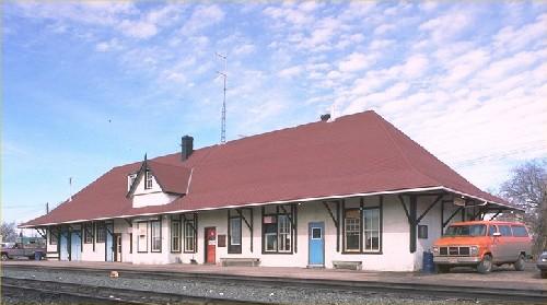
Biggar Railway Station (Grand Trunk Pacific) National Historic Site of Canada
Biggar, Saskatchewan
The Biggar Railway Station (Grand Trunk Pacific) National Historic Site
of Canada is a large, one-and-a-half-storey, light timber frame
structure built in the first decade of the 20th century. It is located
on the southern boundary of the town of Biggar, Saskatchewan.
The heritage value of this site resides in its association with the
Grand Trunk Pacific Railway as illustrated by the building's location,
setting, and architecture. The Grand Trunk Pacific Railway was created
in 1903 to provide its parent company, the Grand Trunk Railway Company
with a western line and connections. Construction of the station at
Biggar, a virtually uninhabited spot on the prairies, illustrates the
role that railway companies played in the development of western Canada.
Built in 1909 to a Grand Trunk Railway Company standard plan, the Biggar
Railway Station (Grand Trunk Pacific) is a good example of pre-First
World War, western Canadian, rural, railway station design. Its design
was influenced by the "artistic" bungalow style of the early 20th
century. As with other towns created by the railway, Biggar grew from
the station and its status as a divisional point provided a sustained
period of economic growth.
|

©Parks Canada Agency / Agence Parcs Canada, 1990 |
Canadian Bank of Commerce National Historic Site of Canada
Watson, Saskatchewan
The Canadian Bank of Commerce is a two-storey, wood-frame bank building,
designed in a restrained neo-classical style. Its formal elegance stands
out amongst the more vernacular commercial buildings in downtown Watson,
Saskatchewan. Since July 1980, it has housed the Watson and District
Heritage Museum.
The Canadian Bank of Commerce was designated a national historic site in
1976 because of its prefabrication technology and the entrepreneurial
imagination of the bank. The heritage value of this site resides in its
historical associations with the expansion of eastern banks into the
Canadian west as illustrated by the building's physical
characteristics.
The former Canadian Bank of Commerce (CBC) bank at Watson, Saskatchewan
is the largest surviving example of the prefabricated bank buildings
erected by the CBC in railway towns across the prairies. Designed by
Toronto bank architects Darling and Pearson, and prefabricated in
Vancouver by British Columbia Mills, Timber and Trading using a patented
sectional wall system, the bank structures were shipped by railway to
newly established towns and assembled within days. The neo-classical
styling of these wood-frame buildings mimicked the stone and brick bank
buildings of larger urban centres at a minimum cost, and projected the
same air of respectability and confidence. By erecting these buildings
quickly and early, the bank hoped to monopolize local trade. The use of
three standard designs created by Darling and Pearson allowed the bank
to convey a consistent and immediate impression of stability, at a
minimum investment. Erected in 1906-07 using the largest of the three
designs, the Watson Bank is the most intact example. While other banks
also made use of prefab technology, it was the CBC that most fully
exploited the potential of the prefab banks and made them enduring
features of the western Canadian landscape.
|

©Parks Canada Agency / Agence Parcs Canada, 2003 |
Carlton House National Historic Site of Canada
Duck Lake, Saskatchewan
Carlton House National Historic Site of Canada is located in Fort
Carlton Provincial Park, approximately 100 kilometres north of
Saskatoon, Saskatchewan. The site consists of the remains of forts
constructed here, on the banks of the North Saskatchewan River, between
1810 and 1885. There are no visible remains of the 1810 and 1845 forts,
but building foundations and other archaeological remains exist from the
1855 fort. The Province of Saskatchewan has created a reconstruction of
Carlton House based on archaeological findings, which includes five
buildings and a stockade. Surrounding the fort is a flat grassed area,
woods, and the low foothills of the plains.
The Hudson's Bay Company established the first Fort Carlton in 1795
below the confluence of the North and South Saskatchewan rivers. It
operated there for nearly a decade before being relocated approximately
150 kilometres southwest. This new site was strategically located on
major transportation and communication routes linking the north and
south branches of the Saskatchewan River. Several generations of forts
were constructed at this site including structures built in 1810, 1845
and 1855. The North West and Hudson's Bay companies jointly established
the 1810 fortified post in response to hostility from the Cree and
Blackfoot Nations. The two companies operated as separate entities
within a single palisade. The Hudson's Bay Company portion of the joint
fort was referred to as "Carlton House." From then on, this name was
used to refer to the site as a whole. The 1845 and 1855 forts were
constructed after the union of the two companies to accommodate
increased personnel and to repair structural deterioration. During its
occupation, Carlton House was an important fur trade and supply centre;
and, for a short time, the fort was leased from the Hudson's Bay Company
by the North-West Mounted Police as their main base in the Saskatchewan
Valley region.
Between 1871 and 1877, following the purchase of Rupert's Land, the
Canadian government signed seven treaties with the First Nations peoples
of the Northwest. Indian Treaty No.6 negotiations took place at Carlton
House in mid-August 1876. The treaty was signed on August 23 by
representatives of the crown and representatives of the Plains and Woods
Cree. Carlton House remained in continuous operation until it was
destroyed during the North-West Rebellion/Resistance in 1885.
|

©Parks Canada Agency / Agence Parcs Canada, HRS 1035, 1995 |
Claybank Brick Plant National Historic Site of Canada
Claybank, Saskatchewan
Claybank Brick Plant National Historic Site of Canada is a former
industrial complex used for the manufacture of clay bricks from 1914 to
1989. It is located in a predominantly rural area of south-central
Saskatchewan, along the Dirt Hills of the Missouri Coteau, near the
communities of Claybank and Avonlea. The core of the 132-hectare site is
a 37-hectare plant area containing buildings dating from the 1912-1937
period: a factory building, 10 kilns, a laboratory, an office building,
a boiler room, stock sheds, a carpentry shop, residences, outhouses, and
a bunkhouse. The site as a whole extends over a broad area encompassing
internal road and path networks, the main approach to the plant,
vestiges of industrial processes, the narrow-gauge rail line and a spur
line that were used as part of an internal and external transportation
system, and the clay pits in the Dirt Hills, from which clay was
extracted for brick construction.
The heritage value of the Claybank Brick Plant lies in the relatively
intact state of the physical resources from the late 1930s, including
all of the key structures, equipment and industrial landscape elements
from the 1912-1937 era. As such, it is representative of the way in
which functional requirements and efficiency were primary drivers in the
design and construction of industrial facilities. The plant, designed by
Richardson-Lovejoy Engineering Company, was one of Canada's major
producers of domestic clay refractory products, supplying fire-proof,
heat-resistant, non-corrosive bricks for construction across the
country, but especially in Western Canada. The complex is also an intact
example of a self-contained manufacturing enterprise that used materials
extracted on site.
|
©Parks Canada Agency / Agence Parcs Canada, J. Hucker, 2000 |
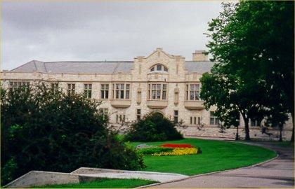
College Building National Historic Site of Canada
Saskatoon, Saskatchewan
College Building is an early twentieth-century, stone university
building constructed in the Collegiate-Gothic style. It is situated at
the heart of the campus of the University of Saskatchewan, amongst the
campus' oldest buildings which are sited around a grassy oval known as
'The Bowl'. Recently additions have been appended to the rear of the
building.
The heritage value of the College Building lies in the building's
historical and visual dominance on the University of Saskatchewan
campus, particularly as illustrated by its prominent siting and its
design in the-then prestigious Collegiate Gothic style. Originally
designed by the Montreal architectural firm of Brown and Vallance as the
College of Agriculture, the building has been expanded with additions in
1985 and 2002.
|

©Parks Canada Agency / Agence Parcs Canada |
Cumberland House National Historic Site of Canada
Cumberland House, Saskatchewan
Cumberland House National Historic Site of Canada is located on Pine
Island in the Saskatchewan River in the district of Cumberland Lake,
Ontario. Cumberland House was the Hudson's Bay Company first inland
fur-trading post, around which Saskatchewan's oldest permanent
settlement was founded in 1774 by Samuel Hearne, explorer and
fur-trader. This community's only visible remnant today is a thick,
stone-walled 1890s powder house, once used for storing gunpowder. Also
preserved at the site are parts of the Northcote, a fur trade steamboat
used at Batoche during the North-West Resistance. Adjacent to Cumberland
House is the Cumberland House Cree Nation Reserve, part of the original
Cumberland House settlement.
Cumberland House is the Hudson's Bay Company's first inland fur-trading
post, and also Saskatchewan's oldest permanent settlement. By the late
1700s rival Montréal traders were intercepting trappers on their way to
trade with the Hudson's Bay Company posts on Hudson's Bay. To counter
this Samuel Hearne set out from York Factory and founded Cumberland
House in 1774. This, the company's first great inland trading post,
marks a change in policy. Protected by a palisade the site was
strategically located near major canoe routes and potential First
Nations trading partners. From this time the Hudson's Bay Company no
longer traded primarily at its forts on Hudson Bay. In 1793, the
original post relocated two kilometres west to a site, on and adjacent
to present-day Provincial Park property, where it continued operating
until 1965.
As the Hudson's Bay Company extended its posts inland, Cumberland House
became an important administrative, distribution and trading centre. Its
role, however, declined after the Hudson's Bay Company's 1821 union with
the North West Company, and as more direct trade routes to the interior
developed. Norway House on Lake Winnipeg eventually became the inland
headquarters. Today the powder house, a rare example of a 19th century
HBC gunpowder storage facility, is the only remaining original structure
at Cumberland House. From 1874 the Hudson's Bay Company's first
steam-powered sternwheeler, the Northcote, began plying the Saskatchewan
River. Cumberland House became an important centre for steamboat freight
and passengers. During the 1885 Resistance the Northcote transported
troops and supplies for the assault on Batoche and afterwards evacuated
causalities to Saskatoon. In 1886 the Northcote was beached and by 1900
the Hudson Bay Company's steamships ceased operations. In 1925
Cumberland House's 150 year role as transportation hub and distribution
centre ended when the railway reached Flin Flon.
|

©Parks Canada Agency / Agence Parcs Canada |
Cypress Hills Massacre National Historic Site of Canada
Fort Walsh, Saskatchewan
1873 attack on Assiniboines by wolf hunters, North West Mounted Police
restored order.
Cypress Hills Massacre National Historic Site of Canada is located about
2 km south of Fort Walsh National Historic Site of Canada in a broad
valley bottom where American traders attacked a Nakoda camp. The rolling
Prairies landscape is broken only by reconstructions of two former
trading posts, Farwell's and Solomon's, involved in the
massacre.
The heritage value of Cypress Hills Massacre National Historic Site of
Canada resides in its witness to the event of June 1, 1873 when a group
of American "wolfers" attacked the Nakoda camp near Farwell's and
Solomon's trading posts in a dispute over horses. Value lies in those
landscape and archaeological resources associated with the battle, in
the setting, and in the spiritual identity of the locations where the
remains of those who lost their lives were interred. The Royal Canadian
Mounted Police reconstructed Solomon's and Farwell's trading posts as a
centennial project and Parks Canada conducted selective archaeological
investigation of the trading post sites in 1972.
|

©Parks Canada Agency / Agence Parcs Canada, Kate MacFarlane, 2007 |
Doukhobor Dugout House National Historic Site of Canada
Blaine Lake, Saskatchewan
The Doukhobor Dugout House National Historic Site of Canada is located
alongside a tributary creek on the western shore of the North
Saskatchewan River. It is now an archaeological site found in a steep
coulee surrounded by cultivated parkland. One of many such dugout houses
constructed by Doukhobors before relocating to their nearby village of
Oospenia, the visible remains of this one-room structure include
portions of its log walls, dovetailed joints, dowel pins, door hinges,
and a window frame.
The Doukhobor Dugout House was one of several practical yet temporary
'cave' dwellings constructed at this site in 1899 and used until 1904
when the Doukhobors moved to their nearby village of Oospenia. When
originally constructed in the side of a ravine, the hollowed out area
was enclosed with three walls built of logs. The front wall was pierced
by a door and a window and protected by a sod roof. During these five
years, nearly 300 people lived in one of several structures such as
this, with a single dugout house capable of housing nine families, who
cooked and slept in an area of about 40.5 square metres (436 square
feet). Although these temporary structures were usually stripped or
plowed under when they were abandoned in favour of more permanent
dwellings, the surviving remains of this dugout house recall the
challenges faced by these early settlers and the practical solutions
they employed to overcome them. This site speaks to the experience of
not only the Doukhobors but to other immigrant groups who played a
crucial role in settling the Canadian prairies.
|
©Parks Canada Agency / Agence Parcs Canada, Judith Dufresne, 2004
©Parks Canada Agency / Agence Parcs Canada, Judith Dufresne, 2004
©Parks Canada Agency / Agence Parcs Canada, Judith Dufresne, 2004 |
Doukhobors at Veregin National Historic Site of Canada
Veregin, Saskatchewan
Located in rural Saskatchewan, the Doukhobors at Veregin National
Historic Site of Canada was a centre for the larger Doukhobour
communities in the general area. The site itself is a level plot
surrounded by roads, the central feature of which is a large and very
handsomely designed prayer home. Buildings original to the site, and
others moved to the site combine to provide an understanding of the
history of the Doukhobor people in Canada.
The Doukhobors originated in southern Russia as a breakaway sect from
the Russian Orthodox Church. After several moves within Russia, the
Doukhobors began immigrating to Canada in the early 20th century.
Inspired by their leader, Peter V. Verigin, the Doukhobors created the
Veregin Settlement. This settlement played an essential role as an
administrative, distribution, and spiritual centre for the Doukhobor
community in the region. The settlement was established in 1904, and was
the headquarters of the Christian Community of Universal Brotherhood
between 1917 and 1931. The community declined after this point, but the
settlement was revived in the 1980s as a heritage village dedicated to
presenting the history of the Doukhobors. The spectacular two-storey
prayer home, which originally served as the residence of the head of the
community as well as the spiritual and administrative centre for
Doukhobors arriving in Canada, currently operates as a museum and
continues to play an important role within the Doukhobor
community.
|

©Parks Canada Agency / Agence Parcs Canada, A. Roos, 2007 |
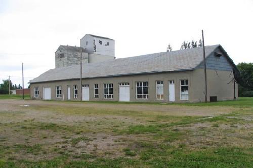
Esterhazy Flour Mill National Historic Site of Canada
Esterhazy, Saskatchewan
Esterhazy Flour Mill National Historic Site of Canada is an early
20th-century flour mill located near the western end of the village of
Esterhazy, Saskatchewan. Situated on an open uneven lot, the site
consists of a flour mill and attached grain elevator; three storage
sheds, one with an attached office; a small engine room; and a
metal-clad oil storage shed. The mill is a rare and complete
illustration of flour milling technology that was crucial to the grain
industry in Saskatchewan and contributed to the development of
communities such as Esterhazy.
The Esterhazy Flour Mill is a rare and complete illustration of a period
of flour milling technology that was crucial to the early 20th-century
grain industry. Soon after the village of Esterhazy was established in
1903, interest was expressed in having a flour mill built in the
community. After receiving positive feedback for the enterprise, James
Saunders acquired property in the village and began the construction of
a flour mill and an elevator. By 1907 the Esterhazy Flour Mill was in
full operation, and by 1913, had ground 40,000 bushels of wheat. During
the early development of Saskatchewan and the West, milling and
supplying flour to communities was very important for local and regional
economies. Such an enterprise facilitated prosperity for the community
and contributed to the growth and development of villages such as
Esterhazy. The presence of a successful flour mill also encouraged
immigration and settlement in the area.
|
©Parks Canada Agency / Agence Parcs Canada, 2003 |
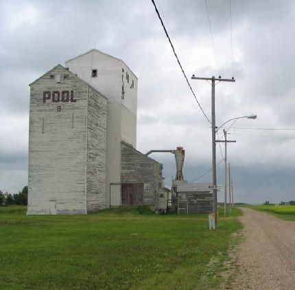
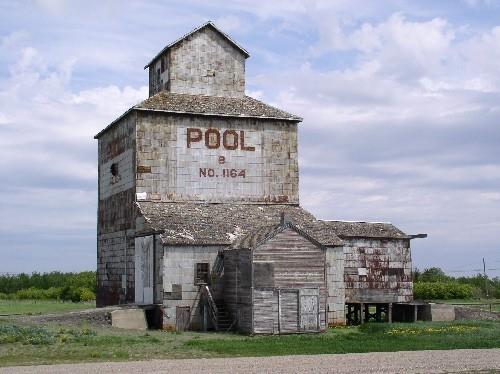
Fleming Lake of the Woods Grain Elevator National Historic Site of Canada
Fleming, Saskatchewan
Fleming Lake of the Woods Grain Elevator National Historic Site of
Canada is a wooden, hipped roof grain elevator, located along the
Trans-Canada Highway, five kilometres west of the Manitoba border. It is
situated south of the Canadian Pacific Railway (CPR) mainline, between
the highway and the community of Fleming, Saskatchewan. This National
Historic Site was demolished by fire in February 2010.
Once part of a row of four grain elevators, the Fleming Lake of the
Woods Grain Elevator now stands sentinel on a flat landscape along the
Trans-Canada Highway and the CPR main line. One of the oldest known
surviving wooden crib-construction grain elevators in Western Canada,
the Fleming Lake of the Woods Grain Elevator has an overall vertical
emphasis and a typical late 19th-century design, in which the main
structure's four exterior walls terminate at eaves about two-thirds of
the way up, at which point a hipped roof supports a square cupola. A
sloped-roof, wooden lean-to receiving shed is attached at the base on
one side and has a ramp leading into it with a shallow incline.
Constructed in 1895, the Fleming Lake of the Woods Grain Elevator is
associated with the genesis of the modern system of grain handling,
which took place between 1876 and 1900, and is one of only two surviving
grain elevators from this period. By the early 20th century,
construction of this hipped roof style of grain elevator became less
common, as the monitor-roof "standard plan" design became more dominant.
Grain elevators have come to be accepted as icons of the Prairies, and
the Fleming Lake of the Woods Grain Elevator, with its surviving wooden
massing and rare roof profile, standing tall against the horizon, next
to the CPR main line, is a rare surviving example of this evocative
symbol of the early history of the grain industry in Western
Canada.
|

©Parks Canada Agency / Agence Parcs Canada, 1988 |
Forestry Farm Park and Zoo National Historic Site of Canada
Saskatoon, Saskatchewan
Currently operating as a zoo and park within the city of Saskatoon, the
Forestry Farm Park and Zoo opened in 1913 in the community of Sutherland
as a tree nursery station and model farm under the Forestry Branch of
the federal Department of the Interior. The complex eventually grew to
include staff residences, tree packing and storage areas, a pumphouse
for the irrigation system, a greenhouse, botanists' research facility, a
blacksmith shop, as well as a barn. Laid out to resemble a progressive
farmyard, these buildings have all been adapted for use in the Saskatoon
Zoo.
The balance of the site was taken up by the field operations of planting
and harvesting tree seedlings, planting shelterbelts to protect the site
and demonstrate the effectiveness of trees on the prairie, fields of
experimental plantings, and park-like grounds around the farm buildings
to illustrate the benefit of ornamental landscaping. A significant
amount of this landscape remains. Closed as a tree nursery in 1965, the
site became the Forestry Farm Park and Saskatoon Zoo in 1972.
The Forestry Park Farm and Zoo was designated a national historic site
in 1990 by virtue of its role as a Forest Nursery Station. The
challenges of settlement and agriculture on the prairies prompted the
development of new and scientific farming methods, supported by the
Department of the Interior. Trees and shelterbelts were found to be part
of the solution. Two tree nursery stations were built by the federal
Forestry Branch in Saskatchewan, in 1903 at Indian Head and in 1913 in
the community of Sutherland, a rail divisional point near
Saskatoon.
The rectangular site was organized into an idealized model farm, with
the "farmyard" containing the Superintendent's residence set in
landscaped grounds, with the operational buildings to the rear. To the
south, east and north stretched propagation fields, trial shelterbelts
and experimental plots. As the trees grew, the Nursery Station also
acted as a park for visitors and residents of Saskatoon. Trees were
distributed across the Prairies to become vast reaches of protecting
shelterbelts that changed the landscape of the agricultural
districts.
By the time that most agricultural lands were settled in 1936, both
Indian Head and Sutherland nursery stations were administered by the
Prairie Farm Rehabilitation Administration ( PFRA ), because tree
planting was integral to efforts to combat the drought and soil drifting
of the Depression. In 1965, nursery activity was consolidated in Indian
Head. The eastern half of the Sutherland site was turned over to the
Research Branch of the Canadian Department of Agriculture, while the
remaining 144 acres were sold to the City of Saskatoon in 1966. In 1972
a zoo featuring indigenous animals opened adjacent to the nursery
station buildings.
The ornamental plantings and larger landscaping features have been
maintained and enhanced, including the addition of two new theme
gardens. The fields that once provided oats, graze and hay for the
farmhorses now provide hay for the zoo. The nursery supplies trees to
the City of Saskatoon.
|
©Parks Canada Agency / Agence Parcs Canada, Allison Sarkar |
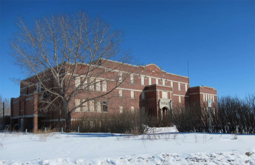
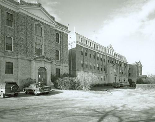
Former Muscowequan Indian Residential School National Historic Site of Canada
Lestock, Saskatchewan
The large, three-storey former school building was built in 1930-31 to
replace residential school buildings dating to the late-19th century,
and remained open until 1997. It was once part of a large school
property that included a working farm, outbuildings, playgrounds, and
skating rinks. At least 35 unmarked graves have been found on the former
school grounds since the 1990s. It is the only standing residential
school in Saskatchewan, and one of the few remaining residential school
buildings in Canada.
Muscowequan Indian Residential School functioned within the system of
residential schools in Canada that was imposed on Indigenous Peoples by
the federal government and certain churches or religious organizations,
who worked together in a deliberate effort to assimilate Indigenous
children and convert them to Christianity by separating them from their
families, cultures, languages, and traditions. Until 1969, Muscowequan
Indian Residential School was operated by the Missionary Oblates of Mary
Immaculate, a Roman Catholic missionary congregation, and staffed by the
Sisters of Charity of Montreal (Grey Nuns) and the Missionary Oblate
Sisters of the Sacred Heart and of Mary Immaculate. In the 1980s, the
site came under the administrative control of a local First Nations
organization and was among the last residential schools to close in
Canada.
For over a century, First Nations and Métis children from Treaty 4
Territory, across Saskatchewan, and elsewhere in Canada were forced to
attend this residential school. They faced severe discipline, punishment
and abuse, harsh labour, inadequate nutrition, poor living conditions,
separation from siblings and cousins attending the school, the attempted
suppression of their language and cultures, and isolation from their
families and home communities. Many children ran away, some to be later
returned by force. Some children died while attending the school. In the
face of threats by government officials of fines or imprisonment,
Indigenous families engaged in acts of resistance such as refusing to
send their children to school, withdrawing them without permission, and
writing letters to government officials protesting the poor treatment of
their children. The far-reaching effects of the residential school
experience continue to have significant impacts on former students,
their families, and communities today.
|

©Parks Canada Agency / Agence Parcs Canada, 1980 |
Former Prince Albert City Hall National Historic Site of Canada
Prince Albert, Saskatchewan
Two storeys high and made of brown brick veneer on a rubble stone
foundation, the Former Prince Albert City Hall National Historic Site of
Canada is located in the town of Prince Albert, Saskatchewan. Its bell
tower signals time and events in this multifunctional space. Presently,
as the Prince Albert Town Hall and Opera House, the building shares a
landscaped public square with the new city hall.
Incorporated as a town in 1885, the Prince Albert civic council hired
Hamilton architect F.J.Rostrick and Son to design the building. A local
contracting firm, A. and W.B. Goodfellow, used brick and lumber
manufactured locally in the construction. The lot was raised from the
street, a common practice to enhance its perceived size, with a yard
planted in trees and shrubs. The building's grand scale and formal
detailing offset the restrained design of the exterior. Little of the
interior remains beyond the layout of the front entry and some of the
door and window trim. The opera house space has been reconfigured into
two floors, while the main staircase and council chambers room across
the front are more intact.
|

©Parks Canada Agency / Agence Parcs Canada |
Fort à la Corne National Historic Site of Canada
Kinistino, Saskatchewan
This region was important in the fur trade from the time that Louis de
la Corne built Fort St. Louis, the most westerly of the French posts,
near here in 1753. The area was occupied in the 1770' s by independent
Canadian traders and, after 1794, by the North West Company's Fort St.
Louis and the competing Hudson's Bay Comapany's Carlton House. The site
was abandoned in 1805, but about 1846 the Hudson's Bay Company
re-established a post, naming it Fort à la Corne. This post was moved
slightly up-river in 1887 and closed in 1932.
|
©Parks Canada Agency / Agence Parcs Canada |
Fort Battleford National Historic Site of Canada
Battleford, Saskatchewan
North West Mounted Police headquarters, 1876
Fort Battleford showcases the role of the North West Mounted Police in
the Canadian West. The fort was established in 1876 and abandoned in
1924. It offers five original buildings, four with period furniture. The
stockades and bastions are reconstructed, and the barracks has an
interpretive display.
Fort Battleford is an early North West Mounted Police post located on
the edge of the town of Battleford at the junction of the Battle and
North Saskatchewan rivers. Built resources include several small wooden
buildings within a stockade.
The heritage value of Fort Battleford National Historic Site of Canada
lies in its historical associations with the NWMP presence in what was
then the North West Territories, 1876-1885, as illustrated by the site
and its surviving resources. Fort Battleford was established by the
North West Mounted Police in 1876 and closed in 1924. At the time it was
built, Battleford was capital of Canada's newly acquired North West
Territories. The site is now operated by Parks Canada and is open to the
public.
|

©Parks Canada Agency / Agence Parcs Canada |
Fort Espérance National Historic Site of Canada
Rocanville, Saskatchewan
Remains of 2 North West Company fur trade posts.
Fort Espérance National Historic Site of Canada is an archaeological
site that is believed to contain the remains of two late 18th- and early
19th-century fur trade forts, both known as Fort Espérance. It is
located in the Qu'Appelle Valley between Rocanville and Spy Hill,
Saskatchewan.
The heritage value of the site lies in its historical associations with
the North West Company as illustrated by its natural setting and
archaeological remains. Robert Grant established Fort Espérance in
1785-87 as the chief fort of the North West Company in the Great Plains.
It was later named after Alexis L'Espérance, a famous guide and
canoeist. It was abandoned in 1810, then rebuilt on a nearby knoll in
1816 (Fort Espérance II), and replaced in 1819 by another North West
Company post 22.5 kilometres (14 miles) to the east. From 1821 to 1824
it came under the control of the Hudson's Bay Company. It ceased to
exist in 1824.
|
©Parks Canada Agency / Agence Parcs Canada, Elaine Rohatensky

©Parks Canada Agency / Agence Parcs Canada, 2005 |
Fort Livingstone National Historic Site of Canada
Pelly, Saskatchewan
Original headquarters of North West Mounted Police.
Fort Livingstone is located in east central Saskatchewan near the
Manitoba border. Fort Livingstone, built in 1874, was the first
permanent post of the North-West Mounted Police and it briefly housed
the territorial government of the North-West Territories prior to its
move to Battleford in 1878.
Fort Livingstone National Historic Site of Canada is an archaeological
site that once housed the first North West Mounted Police barracks in
the west. Located on an upland peninsula above the east bank of Snake
Creek near its junction with the Swan River, it is approximately 16
kilometres north of the town of Pelly, Saskatchewan.
The heritage value of Fort Livingstone lies in its historical
associations with the Government of Canada and the North West Mounted
Police (NWMP) as illustrated by the setting of the fort and the remnants
it contains describing life during NWMP occupation. Fort Livingstone was
built in 1874-75 by the Department of Public Works, and was originally
known as Swan River Barracks. In 1884, shortly after the territorial
capital was removed in 1876, the fort was destroyed by prairie fire. The
fort once housed 185 men and contained sufficient buildings to
accommodate them in a remote location. The fort included Married Men's
Quarters, Men's Quarters, Officers' Quarters, a hospital and three
unidentified buildings or structures of which remnants remain.
|
©Parks Canada Agency / Agence Parcs Canada

©Parks Canada Agency / Agence Parcs Canada, 2007 |
Fort Pelly National Historic Site of Canada
Pelly, Saskatchewan
Remains of Hudson's Bay Company fur trade post.
Fort Pelly National Historic Site is located in east central
Saskatchewan near the Manitoba border. Fort Pelly was a fur trade post
established by the Hudson's Bay Company in 1856.
Fort Pelly National Historic Site of Canada is an archaeological site
that contains remains of Hudson's Bay Company fur trade post located at
the elbow of the Assiniboine River near Swan River,
Saskatchewan.
The heritage value of Fort Pelly lies in its associations with the
Hudson's Bay Company as illustrated by the site, setting and
archaeological remains. Fort Pelly was established as a fur trade post
by the Hudson's Bay Company in 1793, but the present fort was not
constructed until 1856. It was built on higher ground than its
predecessor by Chief Factor W.J. Christie, and was a large establishment
with a strong agricultural focus. It was abandoned in 1912. The fort was
sold in 1921 at which time all of its buildings were torn down or
removed. Since becoming a National Historic Site of Canada managed by
Parks Canada in 1959, it has been the site of archaeological
investigation.
|

©Parks Canada Agency / Agence Parcs Canada |
Fort Pitt National Historic Site of Canada
Fort Pitt Provincial Park, Frenchman Butte No. 501 Municipality, Saskatchewan
Fort Pitt National Historic Site of Canada is located in Fort Pitt
Provincial Park, approximately 5km north east of Hewitt Landing in
western Saskatchewan. The site consists of a field located on the North
Saskatchewan River. Archaeological remains of two forts on the site have
been located, partially excavated and presented for interpretive
purposes. As a result of these excavations the outline of all buildings
and of the palisade is visible. A reconstructed building from the second
fort can also be seen. There is an HSMBC cairn in addition to two
plaques commemorating Fort Pitt and Big Bear.
In the winter of 1829-30 Chief Factor John Rowand of the Hudson's Bay
Company established Fort Pitt as a provision post for travellers. Fort
Pitt also served as a trading post for the local Cree, Assiniboine and
Blackfoot. In 1873 a new post was established approximately 100 metres
southwest of the original site which was subsequently abandoned. In 1876
Fort Pitt was the site of the signing of Treaty No. 6 and that same year
a North West Mounted Police base was established on the site. As a
result of several skirmishes during the 1885 rebellion Big Bear's
followers burned several of the fort's buildings to the ground after the
police had withdrawn. The Hudson's Bay Company rebuilt some of the
buildings but the area was no longer profitable so they abandoned the
fort by 1890.
|

©Parks Canada Agency / Agence Parcs Canada |
Fort Qu'Appelle National Historic Site of Canada
Fort Qu'Appelle, Saskatchewan
Fort Qu'Appelle National Historic Site of Canada is situated in the town
of Fort Qu'Appelle in southern Saskatchewan. This fort was originally a
small trading post surrounded by a log palisade on the open prairie. The
site, overlooking the Qu'Appelle River, is now located at the town's
northern perimeter on a grassy lot edged with trees. All that remains
from the 19th-century Hudson's Bay Company trading post is one original
building that now houses a museum. A 20th-century addition has allowed
for expansion. An HSMBC plaque is also located on the site.
Fort Qu'Appelle, a trading post just south of the Qu'Appelle River in
southern Saskatchewan, was established in 1864 by the Hudson's Bay
Company (HBC) at the centre of a network of trails. Although numerous
HBC posts had used the name 'Fort Qu'Appelle' since the early 1800s, the
post established in 1864 was a major provision post for the southern
Prairies. The post was forced to close after approximately eight years
of operation due to the diminishing bison population. The post would
form the basis for the town of Fort Qu'Appelle, Saskatchewan. The fort
was also the site of the negotiations for Indian Treaty No. 4 in 1874
and served as a temporary camp of the Canadian Militia of General
Middleton's command during the 1885 Rebellion.
|

©Parks Canada Agency / Agence Parcs Canada, 1982 |
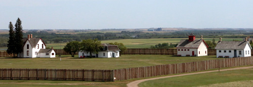
Fort Walsh National Historic Site of Canada
Merryflat, Saskatchewan
Early North West Mounted Police post.
This former North West Mounted Police/Royal Canadian Mounted Police post
(circa 1878-83) was later used (1942-68) to breed horses for the force
and the Musical Ride. Take a guided tour of the fort's buildings, the
Fort Walsh townsite, and two cemeteries. Visitors can also explore the
ridge along Battle Creek on self-guided trails and view exhibits in the
Visitor Reception Centre.
Fort Walsh National Historic Site of Canada is the site of an early
North West Mounted Police post set among the rolling Cypress Hills in
southern Saskatchewan. In the mid-twentieth century, the Royal Canadian
Mounted Police constructed 10 log buildings on the site for its remount
ranch. The siting and architecture of these buildings was intended to
evoke the original nineteenth-century fort.
The heritage value of Fort Walsh National Historic Site lies in the
historical associations as illustrated by the setting and archaeological
evidence of North West Mounted Police presence and activities during the
1875-1883 period. Fort Walsh was constructed in 1875-80 under commander
James Morrow Walsh using local resources, NWMP and Métis labour, was
abandoned in 1883, scavenged for parts to build new posts nearby, and
then burned in 1886. In the mid-twentieth century, the RCMP built a
remount station on the site for breeding and raising horses and
symbolizing the force's bond to its history. Parks Canada now operates
the post as a historic site open to the public.
|

©Parks Canada Agency / Agence Parcs Canada |
Frenchman Butte National Historic Site of Canada
Frenchman Butte, Saskatchewan
Site of 1885 battle, Cree and Canadian troops; Northwest
Rebellion.
Frenchman Butte is one of several locations making up the armed conflict
of 1885. Violence erupted as First Nations bands and the Canadian
Government became frustrated over treaty obligations. A group of First
Nations under the leadership of Big Bear's War Chief, Kah-Paypamhchukwao
(known as Wandering Spirit), encountered the Canadian Militia under
General Strange at Frenchman Butte. Shots were fired and both sides
retreated. It illustrates a period of transition from a traditional way
of life to a new life within the Dominion of Canada.
Frenchman Butte National Historic Site of Canada is a 7.2-hectare
(18-acre) site located along Little Red Deer Creek in western
Saskatchewan. The site marks the place where the Wood Cree and the
Alberta Field Force waged a battle on May 28, 1885 as part of the larger
North West Rebellion. Warrior, Field Force, and civilian pits are
visible along the contours of the rolling landscape.
In 1885, tensions between the Canadian government, Métis and First
Nations peoples over land and treaty issues erupted in a series of
battles long referred to as the North-West Rebellion. On May 28, 1885,
in one of the last armed encounters of this conflict, Cree warriors led
by Wandering Spirit clashed here with Canadian troops under General
Strange. Both sides withdrew after several hours; Strange's forces to
await reinforcements, and the Cree to flee north to Loon Lake. For the
Cree and other Prairie First Nations, 1885 was a turning point in the
difficult transition to reserve life.
|

©Government House, Jimmy Emerson, 2009 |
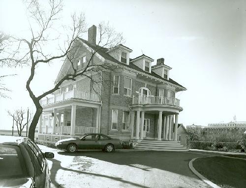
Government House National Historic Site of Canada
Regina, Saskatchewan
Government House, the former residence of the Lieutenant Governor of the
North-West Territories, is set in a landscaped park in Regina,
Saskatchewan. The original building is a two-storey, brick mansion set
on a stone foundation, featuring a low-hipped roof, a porte-cochere, an
attached greenhouse, designed to accommodate formal public areas,
vice-regal private quarters, as well as kitchen, pantry and staff
facilities. The building has been rehabilitated with the addition of a
large wing to one side and now is a large bustling complex that serves
as an administrative building with offices of the Lieutenant Governor of
Saskatchewan, a museum, and a venue for state occasions.
At the time of its completion in 1891, Government House served as
residence for the chief administrator in the territorial capital for
what was then a vast portion of Canada. The capital had moved in 1883
from Battleford to temporary quarters in Regina when the railway
confirmed its southern route across the prairie. Then, on a 22 hectare
(53-acre) site on the south side of Dewdney Avenue, the permanent
residence was built from plans supplied by the office of Thomas Fuller,
Chief Architect for the Federal Department of Public Works. In 1891,
Joseph Royal was the first of four Lieutenant Governors to take up
residence here; with the creation of the Province of Saskatchewan in
1905, Government House continued its administrative and ceremonial
functions for the province's six Lieutenant Governors until
1945.
Government House was built on the open prairie but was intended to evoke
an English country estate. In the spirit of self-sufficiency, the
vice-regal complex had a gardener's cottage, stables, a windmill with a
well and storage tanks for its water system, an icehouse, a henhouse and
extensive vegetable gardens. The gardeners made extensive plantings
along the model of a small mixed farm in Edwardian England, combining
formal areas of trees, shrubs and flower beds delineated from the
outlying service areas. Much of the original acreage was sold to the
City of Regina for various adjacent developments. While the outbuildings
are gone, some of the original landscaped spaces remain.
The house was designed in the Italianate style, chosen for its
simplicity and economy. The original building is two storeys high, clad
with buff brick with limestone trim on a stone foundation, and a low
hipped roof of grey metal. A greenhouse was added to the west side in
1901. In 1907-1908, the heating system was overhauled, electricity was
introduced, and a line connected from the city's water system. In 1921,
a sunporch was added to the north side, and in 1928 a two-storey
ballroom was added on the south side, and additional bedrooms upstairs.
Renovations were also undertaken in the mid-twentieth century and again
in 2005, when a major addition was constructed.
|
©Parks Canada Agency / Agence Parcs Canada, 2014 |
Grasslands National Park of Canada
Headquarters: Val Marie, Saskatchewan
Saskatchewan's rare prairie grasses, dinosaur fossils, and badlands.
With over 70 different species of grass and over 50 different species of
wildflowers, Grasslands has an important role in protecting the prairie
ecosystem! We often hear about problems in the rainforest, but we don't
realize that one of the most endangered ecosystems is right in our
backyard — the native prairies! At least 80% of our native prairie has
been lost. In our southwest corner of Saskatchewan, Grasslands National
Park contains the most intact and greatest example of the remaining
native prairie in Canada.
The grasses are the heart and soul of the prairies and without them,
there wouldn't be a home for such unique animals! This is one place in
Canada where you can see the Buffalo roam and the Deer and the Antelope
play. Grasslands is home to the Black-footed Ferret — often considered
North America's most endangered mammal! Also, the park is the only place
in Canada where you can see Black-tailed Prairie Dogs in the native
habitat!
Grasslands National Park also tells the amazing history of the prairie!
A story of survival and persistence! Ancient teepee rings and bison
drive lanes a just a few remnants of the First Nations people who once
called the prairie wilderness home. Old corrals using river willow
fenceposts and remnants of early ranching homesteads dot the landscape
to remind us of the end of the 'wild west' and the transition to
settlement.
|
©Parks Canada Agency / Agence Parcs Canada
©Parks Canada Agency / Agence Parcs Canada

©Parks Canada Agency / Agence Parcs Canada |
Gravelbourg Ecclesiastical Buildings National Historic Site of Canada
Gravelbourg, Saskatchewan
Gravelbourg Ecclesiastical Buildings National Historic Site of Canada is
located in Gravelbourg, a small town set in the open prairie landscape
of southern Saskatchewan. This religious complex comprises a Cathedral,
Bishop's Residence, and Convent. These, the principal elements of the
early settlement, were designed and built by Roman Catholic
French-Canadians during the early 20th century. Prominent at the south
end of Main Street, the Cathedral of Our Lady of the Assumption is
visible for miles around. The large four-storey Convent of Jesus and
Mary, with its monumental façade, contains a college, two schools and
the regional library within its former chapel. The Bishop's residence is
an attractive, large three-storey brick structure. Stylistically, the
buildings follow a Classical Revival theme. This group of Ecclesiastical
Buildings speaks to the French-Canadian colonization efforts of the
Roman Catholic Church in Western Canada.
Gravelbourg has been an important centre for the Roman Catholic Church
and for French-Canadian culture since it was founded in 1907, by Father
Louis-Pierre Gravel. The settlement was declared a town in 1917 and a
diocese in 1930. The church's elevation to cathedral status underlined
the town's position as the principal French speaking community in
Saskatchewan. Designed by Architect Joseph-Ernest Fortin, the religious
complex was the heart of the early community. The Cathedral (1918-1919)
is a dignified composition combining design elements from both the
Romanesque and Italian Renaissance period and is notable for its twin
towers crowned by cupolas. Monseigneur Charles Maillard painted its
elaborate interior between 1921-1931. The Convent, an imposing
structure, was constructed for the Sisters of Jesus and Mary as a
convent and boarding school for girls in 1917. In 1927, two large
additional wings extended the structure's length to 300 feet and its
capacity to 400 students. This former convent is now a multi-educational
centre containing two schools, a library and a continuing education
college. The Bishop's residence (1918), one of the largest houses in the
community, reflects the presence of the church through its proximity to
the Cathedral and its Classical Revival Style.
|
|
Gray Burial Site National Historic Site of Canada
Swift Current, Saskatchewan
Gray Burial Site National Historic Site of Canada is located on a farm
north-west of the town of Swift Current, Saskatchewan. At the site
numerous ancient human burials are concentrated in a small area on a
hillside, the slope of which gradually becomes a ravine south of the
site. The area surrounding the Gray Burial Site comprises moderately
rolling hills composed of Aeolian sand covered with short grass
vegetation.
The heritage value of Gray Burial Site National Historic Site of Canada
lies in its association with it being one of the oldest burial sites in
the Canadian Prairies. This outstanding example of a mortuary site is
determined to have been established in 3000 B.C. Gray Burial Site
appears to house archaeological and technological remains associated
with the Oxbow Complex. The Gray Site constitutes a unique window on the
human occupants of the Canadian prairies in the third millennium B.C.
Gray Burial Site is associated with a hunter-gatherer group whose
members primarily hunted bison herds, other mammals and birds, and who
were seasonal gatherers. They regularly returned to this location to
bury their dead over an extended period of time. To date approximately
87 burials containing the remains of about 154 individuals have been
identified. The individual burials display a remarkable degree of
variation in burial techniques.
|
©Parks Canada Agency / Agence Parcs Canada |
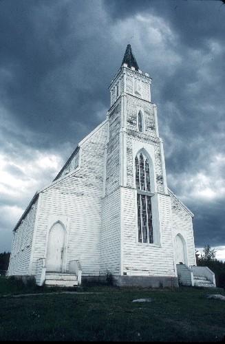
Holy Trinity Church National Historic Site of Canada
Stanley Mission, Saskatchewan
Holy Trinity Church National Historic Site of Canada is situated on a
rocky point on the banks of the Churchill River in Stanley Mission,
Saskatchewan. The church was built near a Cree settlement between 1854
and 1860, as a part of an Anglican missionary complex. The oldest extant
building in Saskatchewan, Holy Trinity Church is a large, white,
wood-frame building built in the Gothic Revival style. Towering to a
height of 23 metres, its white spire can be seen for a great distance
against the boreal forest.
Reverend James Settee of the Church Missionary Society of the Church of
England established the mission at Lac La Ronge for the Cree people in
1845. The mission moved to its present location in 1852, as it was
considered more suitable for farming and fishing. Construction began
under the new minister, Reverend Robert Hunt, on a complex that
eventually included a carpentry shop, warehouse, school, parsonage, barn
and ice-house. The site for the church on a rocky point was cleared in
1853, while timber was cut to dry from the surrounding mixed boreal
forest.
Reverend Hunt designed the mission church and hired a chief carpenter
from Red River, but much of the construction work was done by local
people. Locally cut, heavy timber was used in the frame, with mud and
rubble infill and split weatherboard sheathing. Stone footings for the
foundation and wood shingles were also made of local materials, while
tools, nails, hardware, coloured glass and hardwoods were imported from
England. The spire and weathervane were secured in late winter of 1860,
after six years of labour. Holy Trinity held its first service, in Cree,
on June 10, 1860.
Inside is a collection of Gothic architectural motifs such as pointed
wall openings between the tall nave and the side aisles, a ceiling with
an elaborate beamed vault, the clerestory and first floor windows with
squares of coloured glass, a narrowed chancel at one end and the
entrance at the other end beneath the tower.
|
©Parks Canada Agency / Agence Parcs Canada |
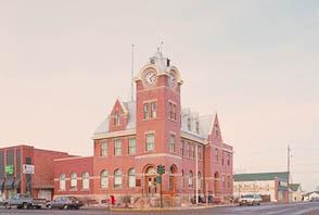
Humboldt Post Office National Historic Site of Canada
Humboldt, Saskatchewan
At the most prominent intersection in the Saskatchewan city of Humboldt
(113 km east of Saskatoon) is located the Humboldt Post Office National
Historic Site of Canada. Constructed in 1911-1912, it is a
two-and-a-half-storey, red-brown brick building with a high mansard roof
sheathed in silver metal. A four-storey bell and clock tower anchors the
principal corner. This Romanesque Revival style former post office has
buff limestone coping and foundations. A low addition on the north side
along Main Street picks up the shape and spacing of the original
windows.
When the town incorporated in 1907, it was experiencing a lively period
of growth fueled by successful agricultural development in the
surrounding parkland. The decision by the federal government to install
this Government of Canada building, which included a post office, a
customs and excise building and its telegraph office, confirmed the rise
of Humboldt over neighbouring towns. Like many Saskatchewan towns, its
growth plateaued creating a stable and prosperous population. The
Humboldt Post Office remains one of the dominant buildings on Main
Street and is a landmark in the community.
The Humboldt Post Office was constructed between 1911 and 1912 using a
particularly attractive design supplied by the Department of Public
Works in Ottawa as part of the Federal Government's push to provide
essential services in developing areas. Its plans were signed by David
Ewart of the Office of the Dominion Architect. It is a
two-and-a-half-storey building with large dormered gables and stone
labels set into the steeply-pitched mansard roof. A four-storey clock
and bell tower anchors the corner and also becomes the double entrance
to the post office. The customs entrance, less used by the public, is
through a third door halfway along the south elevation on 6th Avenue.
The windows, doors and dormers on the first floor are round-headed in
the Romanesque style, detailed with brick voussoirs and lugsills, while
windows on the second floor and tower are flat-headed. A belt course at
the roofline and along the base of the tower creates visual
interest.
Within its walls were a range of federal government services, including
a post office, customs, and weights and measures office located on the
first floor, and a customs and inland revenue building and an office for
the commanding officer of the Royal Canadian Mounted Police (RCMP)
located on the second floor. Remains of the caretaker's quarters are
still readily apparent under the angled trusses of the third floor. The
RCMP maintained living quarters for its officers here from 1935 to 1964
after the customs office closed. Humboldt's local police force also kept
an office here in the 1940s.
|
|
Île-à-la-Crosse National Historic Site of Canada
Île-à-la-Crosse, Saskatchewan
Indians and Europeans have lived together here for over two centuries.
Long before the arrival of the white man, the Indians had been
congregating here each summer to fish, feat, hold councils and play
lacrosse, whence the name of the lake. The first trading post,
established by Louis Primeau in 1775, became, after 1790, an important
provision and storage depot for the North West Company, as well as a key
staging point on the route to the rich Athabasca district. The Hudson's
Bay Company established its first post here in 1799.
|
©Saskatchewan Tourism |
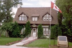
John and Olive Diefenbaker Museum National Historic Site of Canada
Prince Albert, Saskatchewan
Built circa 1912, the John and Olive Diefenbaker Museum in Prince Albert,
Saskatchewan, was John Diefenbaker's home from 1947 to 1957. This decade was
a period of great achievement and professional success in Diefenbaker's life:
he became the Member of Parliament for Prince Albert, the Leader of the
Progressive Conservative Party, and in 1957, Prime Minister. Diefenbaker was
widely known as "the man from Prince Albert", and this home speaks to the
close association between Diefenbaker and this city as well as to his persona
as man of the people. Donated by Diefenbaker to the City of Prince Albert in
1975 to serve as a museum, this home now communicates Diefenbaker's legacy to
Canadians.
John Diefenbaker purchased the house at 246 19th Street West, a modest,
two-storey example of Tudor Revival architecture, in October 1947. Already an
MP in the riding of Lake Centre, Diefenbaker was well known in the community.
A redistribution of ridings prompted Diefenbaker to run in Prince Albert in
1952. He adopted a successful non-partisan approach, talking to residents in
town streets and creating "Diefenbaker Clubs" of prominent citizens from
across the political spectrum. He was Prince Albert's MP from this 1952
victory until his death in 1979.
Diefenbaker lived at the house with his first wife, Edna, and his second
wife, Olive, until he was elected Prime Minister in 1957. After 1957, he
retained ownership of the home but rented it out while he was in Ottawa,
before donating it to the city in 1975. The museum opened in 1983. With the
exception of the kitchen, the home retains the same layout as in
Diefenbaker's day and, with its period furniture and fixtures, gives visitors
the impression of a 1950s era home. As a museum, it presents both
Diefenbaker's personal life and his political career, particularly in regards
to his longstanding connection with the City of Prince Albert. The rooms
feature Diefenbaker's personal artifacts, including a desk once used in his
local campaign offices, as well as furnishings that are not original to the
home but were moved from his Ottawa residence. Photographs in the hallways
and rooms present his long legal and political career in Saskatchewan.
Although serving as Progressive Conservative Party leader and then Prime
Minister drew Diefenbaker away from Prince Albert, he maintained ties to the
city. His public persona reflected both his association with this small
Saskatchewan city as well as his image as someone who could relate to those
outside traditional spheres of influence and power. The John and Olive
Diefenbaker Museum, his former home, commemorates this aspect of
Diefenbaker's history.
|

©Parks Canada Agency / Agence Parcs Canada, 1990 |
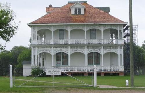
Keyhole Castle National Historic Site of Canada
Prince Albert, Saskatchewan
Keyhole Castle is a private residence, set on an ample lot in Prince
Albert's most refined older residential neighbourhood, East Hill, which
is located on a ridge commanding a view of the downtown commercial
district and the North Saskatchewan River. Constructed in 1913, it is a
two-and-a-half storey red brick mansion in the Queen Anne Revival style
that features an exuberant use of massing and detail, giving the
architecture both its energy and its individualism. The name derives
from the "keyhole" shape of the windows in the dormers of its corner
tower and in its red tile roof. All of its details are painted white for
vivid contrast with the dark brick.
Keyhole Castle in Prince Albert, Saskatchewan was designated a national
historic site in 1975 because it was erected in the Queen Anne Revival
style which exemplifies the eclecticism and individualism in late 19th
and early 20th-century architecture.
The Queen Anne Revival style of architecture is known for its lively
juxtaposition of a variety of stylistic motifs, creating a rich and
exhuberant whole. This is illustrated at Keyhole Castle where the
exterior of the brick house makes a distinctive statement on the street
with its scale, massing, roofline and detailing. It rests on a spacious
double lot of mature plantings. A ''porte cochère'' on the tower side
balances the gabled front entrance with the one-storey sunroom and
gallery on the opposite side. The fanciful roof of red Cuban tile is
punctuated by a conical tower and several scrolled gables with white
trim, keyhole windows and a bracketed cornice. Brick detailing around
the openings play off in a rhythm against the patterns of the roof
brackets, the columns by the gallery and the balustrades under the lower
front windows.
Prince Albert is the gateway to northern Saskatchewan. The original
owner of Keyhole Castle, Sam McLeod (1853-1929) was one of its pioneer
merchants, a lumberman and later a politician. He brought in an American
architect, Erich W. Wojahn, to design Keyhole Castle. Its 1219 square
metres (4,000 square feet) include the usual domestic features for a
prestigious home of the period, as well as a library, spacious sunroom
and gallery, servant's room and a small ballroom set under the steeply
pitched roof of the third floor. Luxurious materials such as exotic
hardwoods, inlays and marbles are used in the finishing, as well as gold
leaf detailing in the dining room, beveled and stained glass, and
custom-made door and window hardware throughout.
Keyhole Castle, well known to the community of Prince Albert, represents
the optimism and vision of the early citizens of this northern
community.
|
|
Last Mountain Lake Bird Sanctuary National Historic Site of Canada
Last Mountain Valley, Saskatchewan
Last Mountain Lake Bird Sanctuary National Historic Site of Canada is
located at the northern end of Last Mountain Lake, just north of Regina.
It is a natural landscape of shoreline, wetlands, native grasslands,
cultivated fields, a lake and islands that is an important nesting place
and stopover area for many migratory birds. It is a largely natural
landscape with a subtle imprint of human management elements, such as
cultivated fields, access roads and water management structures.
On the recommendation of Edgar Dewdney, Lieutenant-Governor of the
North-West Territories, this sanctuary was set aside in 1887 for the
protection of wildfowl, the first such reserve on the continent. It was
established as a federal migratory bird sanctuary four years after
Parliament passed the Migratory Birds Convention Act of 1917.
Internationally recognized, this wildlife area is a migration stopover
point in spring and fall for hundreds of thousands of waterfowl, cranes
and countless smaller birds, and a summer nesting area for over 100
species, including several rare species.
|

©City of Saskatoon, Kathlyn Szalasznyj, 2005 |
Marr Residence National Historic Site of Canada
Saskatoon, Saskatchewan
The second oldest building in Saskatoon, Saskatchewan, the Marr
Residence, constructed in 1884, reflects the experiences and conditions
for many early settlers of that community. More specifically, it is part
of the history of the Temperance Colonization Society, which established
the first major European settlement in the area, facilitated by
cooperation with the resident First Nations population. Marr Residence
is the only survivor of three houses that were part of a field hospital
established during the North-West Rebellion of 1885.
Formed in Ontario in 1882, the Temperance Colonization Society sought to
create a utopian society, where liquor was neither sold nor
manufactured. This spoke to its origins within the wider temperance
movement, which gained prominence in Canada during the 19th century and
blamed alcohol for many social ills. The Temperance Colonization Society
had the support of the government of the day as part of a larger scheme
to settle the West and reflected the government's intention to recreate
the best features of Anglo-Canadian civilization therein. The society
quickly recruited 3,100 would-be colonists and requested over 800,000
hectares of land from the Dominion government.
Alexander and Margaret Marr, and their children, were among the first
European settlers to arrive at the site in the spring of 1883. Their
house, the eighth or ninth to be built in the new community, was begun
in the summer of 1884, with lumber floated downriver from Medicine Hat.
The one-and-a-half storey, wood-frame house, built in a vernacular
Second Empire style with a distinctive mansard roof and dormer windows,
was one of the largest in the village at the time of its construction
when completed.
During the North-West Rebellion of 1885, the Dominion government
dispatched troops, including a medical contingent, and Saskatoon was
chosen as a field hospital site due to its proximity to both the fields
of battle and the navigable South Saskatchewan River. The hospital was
set up in three of Saskatoon's largest homes, one of which was the Marr
Residence, with a staff that included eight doctors and six nurses. This
was the first time in Canadian history that nurses were employed by
military field forces, and as such Marr Residence is directly associated
with the origins of Canadian military nursing.
|
|
Montgomery Place National Historic Site of Canada
Saskatoon, Saskatchewan
Montgomery Place in Saskatoon, Saskatchewan, is an excellent and intact
illustration of the Veterans' Land Act communities established following
the Second World War. The Veterans' Land Act of 1942 was a key element
of the Veterans' Charter which provided most veterans, ex-servicemen and
women, and the disabled with a wide range of benefits later extended to
veterans of the Korean War. Its main goal was to provide veterans with
the means to become financially independent after their return to
civilian life and it included assistance to build their own
homes.
Montgomery Place was built in 1945 on 230 acres of previously rural land
in Cory County, as a residential subdivision adjacent to the city of
Saskatoon. It featured small homes on generous, half-acre (minimum) lots
that the veterans were expected to use as gardens to supplement their
incomes. Property lots in Montgomery Place continue to have distinctive
30-metre frontages, compared with 7.5metre frontages in the inner city,
and 15-metre frontage in other suburban developments in Saskatoon. The
community is heavily treed and very park-like with gently curving
roadways. Other than the perimeter roads, the streets of Montgomery
Place do not have sidewalks. All of the streets are named for Canadian
wartime commanders, for ships and planes, and for battles in which the
Canadian Forces participated, creating a kind of memorial
landscape.
From an initial 28 homes, Montgomery Place has grown to encompass
approximately 900 residences, 2 schools, one church and 4 parks in a
clearly-defined residential subdivision on the southwest edge of the
city of Saskatoon. Today, its residents continue to preserve, honour and
celebrate their community history. It is a strong, vibrant and
tight-knit community, which is very aware of its origins and makes every
effort to honour the original inhabitants and their wartime sacrifices.
Though not the original intent, Montgomery Place has emerged, over time,
as a place of remembrance. Its street and place names honour the
leaders, battles and equipment of the Second World War; the community
has erected two memorials and the annual Remembrance Day ceremonies have
come to attract large crowds. Montgomery Place retains many key elements
of its original design including layout, lot size, set back, street
names, green spaces and recognizable housing plans which contribute to
the "sense of history" of a historic district. Montgomery Place is still
home to some of its original residents, including veterans of the Second
World War and the Korean War. Many of their children and grandchildren
have also made Montgomery Place their home.
|
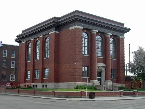
©Government of Saskatchewan, C. Fehr, 2004 |
Moose Jaw Court House National Historic Site of Canada
Moose Jaw, Saskatchewan
Moose Jaw Court House National Historic Site of Canada is a striking
building designed to express the power and respectability of the new
provincial justice system of Saskatchewan of 1908. Its corner location
on a compact raised lot in the downtown district contributes to this
evocative message. This stately, large square courthouse, with its
rigidly symmetrical Beaux Arts design, features Neo-Classical detailing
and is faced with brick and trimmed with pale Bedford stone.
The Moose Jaw Court House, designed by Toronto architects Darling and
Pearson, was constructed in 1908-1909 by the Regina building firm of
Smith Brothers and Wilson. This represents the beginning of an ambitious
program of public works undertaken by Saskatchewan as it sought to
express its own voice as a new, energetic and independent province. This
impressive court house design is an expression of the new province's
independence and confidence, while reflecting the architects' long
experience designing commercial and public buildings. Measuring 17 by 27
metres (56 x 89 feet), the Moose Jaw Court House featured modern steel
construction with cladding of red-brown hydraulic-pressed brick and
dressed Bedford stone. Its Beaux-Arts design features symmetrically
organized classical architectural elements. The building is impressively
sited on a raised corner lot encircled by a low brick and stone
fence.
|
©Parks Canada Agency / Agence Parcs Canada, HRS 0783, 1990 |
Motherwell Homestead National Historic Site of Canada
Abernethy, Saskatchewan
Farm of William Richard Motherwell built in 1882, noted politician and
scientific farmer.
Motherwell Homestead depicts the lifestyles, costumes, and architecture
of the early 20th century. Here you can get a glimpse of the life and
career of pioneer farmer and politician, W.R. Motherwell, and his
significant influence on the development of scientific agriculture in
Western Canada.
Developed by W. R. Motherwell from 1882 to 1939, Motherwell Homestead
consists of a 3.59 hectare farmstead including fields defined by fences
and shelter belt shrub and tree lines, a collection of agricultural
buildings, and a two-storey, stone farmhouse historically known as
Lanark Place.
Motherwell Homestead was designated a national historic site of Canada
because of its architectural interest and its historic associations with
the career of W. R. Motherwell, and as an illustration of a prairie
homestead of western Canada's settlement period.
Motherwell Homestead's heritage value resides in its association with
the career of W. R. Motherwell and in its illustration of an individual
dispersed prairie homestead planned around scientific farming
principles.
|
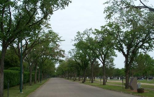
©Parks Canada Agency / Agence Parcs Canada, 2003 |
Next of Kin Memorial Avenue National Historic Site of Canada
Saskatoon, Saskatchewan
Next of Kin Memorial Avenue National Historic Site of Canada is a
picturesque 0.7 kilometre-long "Road of Remembrance" located in Woodlawn
Cemetery in Saskatoon, Saskachewan. The Avenue begins at a pair of stone
pedestals, flanked by a wrought-iron fence, and runs northwards
following the western boundary of the cemetery. It ends in a paved
circle surrounding a stone memorial cairn. The asphalt-paved roadway is
flanked on either side by a single row of 112 stately, mature elm trees,
accompanied by bronze plaques on wrought-iron stands that dedicate each
tree to a deceased soldier.
Following the First World War, the Imperial Order Daughters of the
Empire sponsored and initiated the tradition of planting memorial trees
to honour Saskatoon residents killed in the war. Memorial avenues were
based on two symbol-laden images. The first was the long, straight,
tree-lined roads of France; the second was, as a living memorial, trees
symbolizing the victory of life over death. Initially, 265 trees were
planted in single rows on either side the avenue. Each tree was planted
in individual memory of a deceased First World War soldier and was
accompanied by a standardized bronze plaque bearing his name, rank and
dates of birth and death. The tradition was later expanded to include
tree memorials to casualties of both the Second World War and the Korean
War. The cemetery now contains more than 1200 memorial trees, 112 of
which are on Next of Kin Memorial Avenue.
|

©Parks Canada Agency / Agence Parcs Canada, 1989 |
Old Government House / Saint-Charles Scholasticate National Historic Site of Canada
Battleford, Saskatchewan
Old Government House is the site of the first Territorial Government
House in what is now the Province of Saskatchewan. The building was
destroyed by fire in 2003 and the site now consists of a grassy plateau
with archaeological remains of the former structure. It overlooks the
vast valley of the Saskatchewan and Battle rivers.
Old Government House was designated a national historic site of Canada
because it was the seat of Territorial Government from 1878 to 1883. Its
heritage value resides in its association with the establishment of
federal government in the West. This is best expressed in the dominant
and highly visible site, high above the Battle and Saskatchewan rivers,
the major travel arteries of the time.
|
©Parks Canada Agency / Agence Parcs Canada |
Prince Albert National Park of Canada
Headquarters: Waskesiu Lake, Saskatchewan
Protects slice of northern coniferous forest and wildlife.
Prince Albert National Park protects a slice of the 'boreal' forest. It
is also a meeting place or transition zone between the parkland and the
northern forest. The park features many outstanding natural wonders and
cultural treasures, including the only fully protected white pelican
nesting colony in Canada, the isolated, lakeside cabin of
conservationist Grey Owl and a free-ranging herd of plains bison.
|
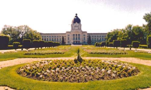
©Parks Canada Agency / Agence Parcs Canada, 1998 |
Saskatchewan Legislative Building and Grounds National Historic Site of Canada
Regina, Saskatchewan
The Saskatchewan Legislative Building and Grounds National Historic Site
of Canada, on the south shore of Regina's Lake Wascana, is a monumental
structure, designed according to Beaux-Arts principles of symmetry,
grandeur and elaborate ornamentation. Three-storeys high, with its long
rectangular section crossed at its centre by a large porticoed pavilion,
the structure rises in a massive dome atop a colonnaded octagon. The
building is a steel construction, sheathed in smooth buff-coloured
limestone. It dominates the surrounding landscaped grounds, laid out in
drives, paths, formal flower gardens and woods of mature trees.
Already the capital of the North-West Territories since 1883, Regina was
confirmed as the capital of the new Province of Saskatchewan the year
after it was inaugurated in 1905. The choice of the building site for
the capitol south of the city boundary provided the space that allowed
then-Premier Walter Scott to hire Montreal landscape architect Frederick
Todd in 1907 to plan the grounds. The Wascana reservoir was enlarged and
deepened to create a lake, the building was sited on a rise of land on
the south shore of the lake, and an extensive public works program
installing drives, paths and plantings commenced. The design of the new
legislature was chosen through an international competition and, in
1907, the commission awarded the contract to the Montreal firm of Edward
and W.S. Maxwell. Their design best captured the spirit of the young
province, its confidence of continued rapid growth and prosperity, and
its partnership in Canada, as well as a visual link between the province
and the British model of government, a constitutional monarchy.
The firm of Peter Lyall and Sons of Montreal began construction in 1908.
In the spring of 1909, the premier decided to replace the red brick
exterior with buff Tyndall limestone from Manitoba, installed under the
direction of stonemasons trained in Britain. Governor-General Earl Grey
laid the cornerstone during a vice-regal visit in 1909 when the building
was still under construction. When construction completed in 1912,
energies were focused on landscaping the surrounding grounds. With its
axial planning and symmetry, various and fine details, and its overall
civic grandeur, the Saskatchewan Legislative Building and Grounds
together form one of the best examples in Canada of a well-preserved
landscape designed according to Beaux-Arts and City Beautiful
principles. The gardens, woods, tennis courts, walkways and drives,
along with the monumental legislature proved the vision of the new
province in 1905 to make this a destination of lasting beauty and
pride.
|

©Parks Canada Agency / Agence Parcs Canada, Marilyn Armstrong-Reynolds, 1990 |
Saskatoon Railway Station (Canadian Pacific) National Historic Site of Canada
Saskatoon, Saskatchewan
The Saskatoon Railway Station is a two-storey, Chateau-style railway
station, built in 1907-08 and enlarged in 1919. It is prominently
located on Idylwyld Drive in downtown Saskatoon.
The Saskatoon Railway Station (Canadian Pacific) was designated a
national historic site in 1976 to commemorate the Canadian Pacific
Railway (CPR) Line. The station exemplifies smaller depots built by the
line during its prosperous years.
The Saskatoon station illustrates the early-20th century period of
tremendous growth and expansion for the CPR. Built at a time when
Saskatoon was the regional centre for three major railway companies, it
reflects the intense rivalry between companies and the CPR's aspiration
to become the predominant railway in Saskatoon. The Saskatoon station is
a good example of the streamlined Chateau style favoured by the CPR
after 1900 for both larger divisional stations and smaller depots. The
building is now privately owned and operated as a restaurant and
offices.
|

©Parks Canada Agency / Agence Parcs Canada, E. Mills, 1994 |
Seager Wheeler's Maple Grove Farm National Historic Site of Canada
Rosthern, Saskatchewan
Seager Wheeler's Maple Grove Farm National Historic Site of Canada is a
17-hectare (42-acre) farmstead 6.5 kilometres east of Rosthern
Saskatchewan, established by farmer, agronomist and pioneering seed
breeder Seager Wheeler on the prairies in 1898. The site includes
various buildings, archaeological resources, and landscape features that
depict a model farm of the Wheat Boom era from 1898-1940.
The heritage value of Seager Wheeler's Maple Grove Farm lies in its
association with the agricultural contribution of its original owner,
Seager Wheeler, in its representation of a typical prairie farm of the
1898-1940 era, and in the integrity of its multi-dimensional cultural
landscape whose buildings, layout and planted landscape survive as a
reflection of the work of their owner during that era. Maple Grove Farm
was established by Seager Wheeler in 1898 and operated by him until
1947. He constructed most of its remaining buildings during the
1908-1928 period, and used the farm property and facilities to conduct
experiments important to the development of agriculture in western
Canada from 1898 to 1940. Although most of the 57-hectare (140-acre)
farm continues to be owned and operated by the Wheeler family, 17
hectares (42 acres) constituting the original farmstead has been severed
for operation by the Seager Wheeler Historic Farm Society as an
agricultural tourism site.
|

©Parks Canada Agency / Agence Parcs Canada, 1989 |
Steele Narrows National Historic Site of Canada
Loon Lake, Saskatchewan
Steele Narrows National Historic Site of Canada is located 10km west of
the village of Loon Lake, Saskatchewan. The site is a flat, grassy
landscape on the east and west sides of Steele Narrows, the channel
connecting Makwa Lake to the north and Sanderson Bay in Upper Makwa Lake
to the south. A bridge spans the narrows. Interpretive panels and white
concrete markers relate the events and indicate their location. On a
hill on the west side of the narrows is an HSMBC commemorative
cairn.
The heritage value of Steele Narrows National Historic Site of Canada
lies in its association with the North West Rebellion. Following the
Battle of Frenchman Butte on 28 May 1885, the First Nations forces led
by Misto-ha-a-Musqua (Big Bear) retreated toward Loon Lake with hostages
from Fort Pitt. On 3 June 1885, Big Bear and his band were overtaken by
Major Steele and his Scouts who formed an elite section of the
North-West Mounted Police. Steele attacked from the west side of the
narrows, thereafter named Steele's Narrow, and after a three hour
exchange of fire the First Nations withdrew northward with their
prisoners, eventually surrendering at Fort Carlton on July 2. The police
retired a few miles west to await re-enforcements and medical aid for
their wounded. This skirmish marked the last engagement of the North
West Rebellion. The site highlights the key events of the
confrontation.
|

©Parks Canada Agency / Agence Parcs Canada, 2003 |
Wanuskewin National Historic Site of Canada
Corman Park, Saskatchewan
Wanuskewin National Historic Site of Canada is located in the Tipperary
Creek (Wanuskewin) Conservation Area on the South Saskatchewan River, in
Saskatchewan. The archaeological sites contained within the 57-hectare
(140 acre) conservation area represent nearly 6000 years of cultural
history relating to the Northern Plains First Nations people. There are
several kinds of remains in the deep coulees along the riverbanks of the
site, including a medicine wheel, camps, tipi rings, and stone
cairns.
Wanuskewin includes 20 archaeological sites, which represent nearly 6000
years of cultural history relating to the Northern Plains First Nations
peoples who lived in deep coulees along the Tipperary Creek and South
Saskatchewan River areas. The pattern of land use is clear, being
richest along the riverbanks and disappearing as the valley becomes
shallower. Therefore, many of the sites are functionally related. Both
lithic scatter as well as in situ remains of Plains Indian cultural
elements ranging from surface features such as tipi rings to buried
campsites over 4,000 years old are found within the site. Also evident
are several major bison kill sites as well as ceremonial boulder
alignments known as medicine wheels. The density of archaeological
materials is so great that the entire area is treated as one large
site.
|
|