|
Park Summaries
British Columbia
All text and photos are copyrighted by Parks Canada or the Canadian Register of Historic Places
(except as noted) and were extracted from either the Parks
Canada or Canada's Historic Places
Websites. Parks with a grey background are managed by Parks Canada.
©Parks Canada Agency / Agence Parcs Canada, Andrew Waldron, 2011 |
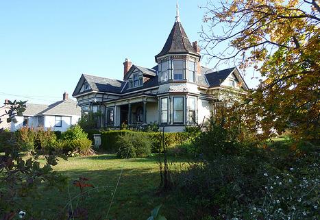
223 Robert Street National Historic Site of Canada
Victoria, British Columbia
223 Robert Street is an ornate one and one-half storey wooden residence
designed in the Queen Anne style. Built in 1905, its picturesque quality
is enhanced by its location in a residential cluster containing several
houses of similar style, scale and age. The house occupies a lot located
near the waterfront in the Victoria West area of Victoria, British
Columbia.
223 Robert Street was designated a National Historic Site of Canada
because it is a particularly good example of the Queen Anne Revival
Style, as expressed in domestic architecture.
On the West Coast, hallmarks of this architectural style, including
cornertowers and rich decorative detailing, were occasionally applied to
wooden picturesque cottage designs with striking results. The house
built for James McLearen Muirhead in 1905 is an outstanding example,
replete with an octagonal corner tower affording ocean views and a rich
array of exterior and interior wood detailing supplied by the Muirhead
family's local planing mill.
|

©Khalsa Diwan Society, Abbotsford |
Abbotsford Sikh Temple National Historic Site of Canada
Abbotsford, British Columbia
Abbotsford Sikh Temple National Historic Site of Canada is located on a
one-acre property at the crest of a hill in the centre of Abbotsford, in
the Lower Fraser Valley of British Columbia. Built in 1911, this simple,
rectangular, gable-roofed building is of wood-frame construction clad in
wood siding. The false fronted façade that faces the street is typical
of Canadian commercial vernacular architecture of the period. A verandah
runs along three sides of the building on the second floor.
The Abbotsford Sikh Temple is an early example of a Sikh temple and was
part of a network of temples that represent the pioneering phase of the
Sikh community in Canada. Built by early immigrants, the structure
reflects the limited resources of the builders and their adaptation of a
Canadian architectural type, namely, the false-front building. Built in
1911 and used continuously since then, the temple is evidence of the
early roots of the Sikh community and of the larger Indo-Canadian
community that is located in this region of Canada. The structure's
simple design blends a Canadian architectural form with all the key
elements of a Sikh religious building's structural traditions including
the prayer hall, the four entrance doors, the Sukh Aasan, (the room
where the Guru Granth Sahib was kept) and the Granthi's quarters on the
second level, the communal kitchen, and the dining area. These
architectural features have religious meaning and symbolize the openness
of the temple to all, regardless of caste, creed or colour.
|

©Parks Canada Agency / Agence Parcs Canada, 2009 |
Barkerville National Historic Site of Canada
Barkerville, British Columbia
Barkerville National Historic Site of Canada is located on Williams
Creek in eastern British Columbia. The historic town was founded in 1862
after the discovery of significant gold deposits in the Cariboo gold
fields, but was destroyed by fire in 1868. Constructed almost
immediately on the ruins of the first, the second Barkerville began a
gradual decline, surviving with reduced mining operations and the
maintenance of government offices. The restoration and rebuilding of the
town in the late-1950s was initiated with the intension of returning
Barkerville to its 1869-1885 state. The townsite, surrounded by huge
pits and ditches from 19th century gold mining, marks the northern
terminus of the Cariboo Wagon Road, and contains within its boundaries
the Chee Kung Tong Building National Historic Site of Canada.
The town of Barkerville on Williams Creek began to grow around 1862
after the discovery of significant gold deposits in the Cariboo gold
fields. The gold fields were the catalyst for economic and political
development in British Colombia. The increased prosperity of Barkerville
was facilitated by the Cariboo road, or Great Wagon Road, constructed by
the colony of British Columbia between 1862 and 1865. The 650
kilometre-long road greatly improved access to the Cariboo gold fields,
beginning at Yale, a major steam port and ending at Barkerville, amidst
the gold fields. The road was part of a plan to boost the economy by
drawing traffic away from American entrepreneurs, by vastly reducing
shipping costs to the mines and by encouraging commerce and settlement
in the interior. Unfortunately, the town of Bakerville was almost
completely destroyed by fire in 1868, leaving only four buildings
intact. A second Barkerville was immediately constructed on the ruins of
the first town. While the community continued to survive based on
periodic mining excitement and the maintenance of government offices,
Barkerville started to decline and unused houses fell into disrepair or
were demolished.
British Columbia's centennial in 1958 provided a catalyst for the
restoration of the town. The provincial government created Barkerville
Historic Provincial Park and reconstructed the town to mirror its
appearance during the 1869-1885 period. This period was chosen because
the Cariboo gold fields and Great Wagon Road to Barkerville fostered
economic and political development in British Colombia. It also marks a
significant date in British Columbia's history with the completion of
the Canadian Pacific Railway.
|

©Parks Canada Agency / Agence Parcs Canada, 1990 |
Bay Street Drill Hall National Historic Site of Canada
Victoria, British Columbia
Bay Street Drill Hall National Historic Site of Canada is a massive
building of brick, steel and concrete construction with a design that
conveys the impression of a monumental medieval fortress. The scale of
the building, its rich architectural detailing, extensive facilities,
and central location on Bay Street near downtown Victoria, British
Columbia, reflect the pride in which Canada's emerging military was held
at the time of its construction and its important role in Canadian
history in the early 20th century.
The Bay Street Drill Hall was built during the militia building campaign
of 1896 to 1918, during which over 100 drill halls and armouries were
erected across the country. The purpose of this campaign was to expand
the visibility of the Canadian militia following its successful
involvement in the South African War and in preparation for the First
World War. The new drill halls and armouries played a significant role
in the militia reform by functioning as both training and recruitment
centres. The results of these training programs were impressive, and
enrolment in the militia increased dramatically, particularly in the
West.
Built between 1914 and 1915, the Bay Street Drill hall consists of a
large two-storey hall, surrounded by armouries, storerooms, lecture
rooms and mess rooms. The building exhibits elements of the Tudor
Revival style, as evidenced in its central, octagonal tower with
crenellated parapet, its ceremonial balcony and its keystones that
combine to create an image of medieval fortifications.
|

©Parks Canada Agency / Agence Parcs Canada, 2008 |
Begbie Hall National Historic Site of Canada
Victoria, British Columbia
Begbie Hall National Historic Site of Canada is located in the Royal
Jubilee Hospital complex in Victoria, British Columbia. It is a large,
three-storey brick building with a flat roof that was purpose-built as a
nurse's residence. The site is now part of a large institutional
setting.
Built in 1926, Begbie Hall represents the recognition and development of
nursing as a profession. This former women's residence was purpose-built
to house students of the Royal Jubilee Hospital School of Nursing, who
cared for patients as part of their training. The hospital was founded
in 1890, and the school of nursing in 1891. Its modern lecture rooms,
laboratories and reference library supported the scientific education
that was critical to their work. Here, as elsewhere in Canada, a place
of their own helped nurses shape a professional role indispensable to
health care within the hospital and in the community. Their success
inspired women to assume new roles in society. This former women's
residence now houses the Corporate Head Offices of the Capital Health
Region.
|

©Parks Canada Agency / Agence Parcs Canada, S.D. Bronson, 1997 |
Binning Residence National Historic Site of Canada
West Vancouver, British Columbia
Binning Residence National Historic Site of Canada is located on a
small, steeply sloped site on a well-treed and quiet residential street
in West Vancouver, British Columbia, with a view of Burrard Inlet. A
small two-bedroom house, it consists of two rectangular volumes that are
stepped down to take advantage of the natural topography of the site.
With its low massing and flat roof and situation within mature
vegetation, the residence virtually disappears into the landscape.
The Binning Residence constitutes a very early illustration of the
Modern movement in residential architecture in Canada. Intended to
provide a model for residential design, it combines a Modern approach to
form and function with an economy and efficiency of construction by
using local materials and up-to-date building technologies. Features
such as its post-and-beam construction, simple rectangular volumes with
flat roofs and deep overhangs, large windows and open interior plan, set
a pattern of design that would influence post-war residential
architecture throughout the 1950s and 1960s. Designed and constructed
during the war when construction materials and labour were difficult to
secure for private homes, the Binning Residence utilized traditional and
local materials to produce a house type that could be mass produced and
was affordable for the average family. The design is also noted for the
careful integration of architecture and landscape. The building's
stepped plan follows the slope of the land and the use of large windows,
wide terraces and overhanging trellises have the effect of extending the
architecture out into the landscape and breaking down the barriers
between interior and exterior space.
Bertram Charles Binning (1909-1976), an artist and a leading promoter of
Modernist ideology, deemed architecture to be the harmonious expression
of science and society. He designed the house in collaboration with
consulting architects C.E. Pratt and R.A.D. Berwick, to express the
union of abstract art and new architectural forms. To that end, he
included a gallery in the house to accommodate a changing selection of
his paintings, ensuring that his domestic environment evolved with his
art. Believing that the aesthetic criteria of harmony, integrity, order
and balance applied to art and architecture alike, Binning worked as an
artist and a teacher, promoting good architectural design in
contemporary urban life.
Although the landscape has evolved, the original artwork has been
replaced by later Binning pieces, and minor modifications and repairs to
the house have occurred, the original design intent has not been
compromised.
|

©Parks Canada Agency / Agence Parcs Canada, Roger Eddy, 2002. |
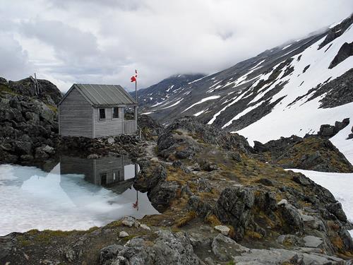
Boat Encampment National Historic Site of Canada
Warsaw Mountain, Red Rock Bay, British Columbia
The Boat Encampment National Historic Site of Canada was originally
located between the mouths of the Wood and Canoe rivers, at the Big Bend
of the Columbia River. In 1973, preceding the hydroelectric development
of the Columbia River, which flooded the area of the original site, the
Historic Sites and Monuments Board of Canada monument marking the site
was relocated to a site near the Mica Dam. Relocated again in 2000, the
monument now rests on a point in the Sprague Bay Recreation Site. The
monument looks out towards the original boat encampment site, currently
under the waters of the Mica Dam Reservoir.
The Boat Encampment served as an important transshipment point for the
fur brigades moving to and from the Columbia River across the continent.
David Thompson, a fur trader under the employ of the Northwest Company,
first visited the site in 1811, wintering there after traversing the
Athabasca Pass. The location remained a meeting place for the following
half century for the fur brigades of both the Northwest Company and
later the Hudson's Bay Company as they awaited pack trains coming over
the mountain from Jasper House, an important supply depot for fur
traders. Previously inaccessible by land, the construction of the Big
Bend loop of the Trans-Canada Highway opened up the area to travelers
and tourists in the spring of 1940. Three decades later, the site was
flooded during the hydroelectric development of the Columbia
River.
|
©Britannia Mine Museum |
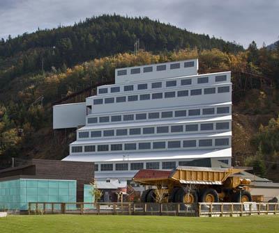
Britannia Mines Concentrator National Historic Site of Canada
Britannia Beach, British Columbia
Britannia Mines Concentrator is a gravity-fed concentrator used to
process copper ore for one of Canada's largest mining operations in the
1920s and 1930s. It is the centrepiece of a complex of buildings
associated with mining and shipping ore, a monolithic structure that
rises in successive stages up the rock face of Mount Sheer at the edge
of Howe Sound, 28 miles (45 kilometres) north of Vancouver. Now owned by
the Britannia Beach Historical Society, it forms part of the British
Columbia Museum of Mining.
The heritage value of Britannia Mines Concentrator National Historic
Site lies in its physical illustration of the innovative technology that
made Britannia Mines an important copper mining site in Canadian
history. Britannia Mines Concentrator was built in 1922-1923 by
Britannia Mines, which had been extracting copper ore in the area around
Mount Sheer on the eastern shore of Howe Sound since 1903. This replaced
earlier gravity concentrators installed on the site in 1904 and 1914.
This steel and concrete structure incorporated new milling and
processing techniques. Designed to process 2,500 tons of ore per day, it
made Britannia the largest producer of copper ore concentrate in the
British Empire between 1925 and 1930. The concentrator continued to
operate until Britannia Mines closed in 1974.
|

©Parks Canada Agency / Agence Parcs Canada, (NHS-images), 2004 |
Britannia Shipyard National Historic Site of Canada
Richmond, British Columbia
The Britannia Shipyard Property National Historic Site of Canada is a
historic park located along the south arm of the Fraser River in
Richmond, British Columbia. The site relates to the area's long
involvement with the salmon fishery. Built out over the water, the
shipyard is part of Steveston's historic "Cannery Row" extending from
Garry Point and the Gulf of Georgia Cannery National Historic Site of
Canada on the west end to London Heritage Farm in the east. The historic
park includes several wooden structures used for cannery and
boat-building purposes between 1890 and the mid 1950s which are not
included in the official recognition.
Britannia Shipyard Property was designated a national historic site in
1991 because its extant boatworks and shipyard are representative of
fishing boat construction and repair activities in Canada's Pacific
Coast salmon fishery.
Originally, the Britannia Shipyard Property was constructed as a cannery
(1890), a function it retained until 1918, after which it was adapted
for use as a boat repair yard. This use persisted until 1980, with
individual buildings within the complex functioning both as part of the
cannery and the boatyard. The yard is representative of the once more
numerous workshop complexes involved in the construction and repair of
shore-based salmon fishery vessels. The heritage value of the national
historic site resides in its historic association with the construction
and repair of salmon fishery boats as illustrated by the 3.3-hectare
site, its location and spatial relationship to the fisheries-related
activities along the Fraser River.
|
©Parks Canada Agency / Agence Parcs Canada, M. Trépannier, 2001 |
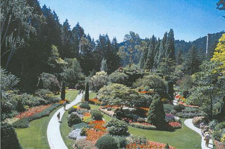
Butchart Gardens National Historic Site of Canada
Brentwood Bay, British Columbia
Butchart Gardens National Historic Site of Canada is an
internationally-known public attraction that has been open to visitors
since 1904. It is located on the Saanich Peninsula, approximately 21
kilometres north of Victoria, British Columbia. The gardens occupy the
site of a former quarry and borders on Tod Inlet. The designated area of
the gardens occupies approximately 5.26 hectares and corresponds to the
areas developed under the guidance of Jennie Butchart between 1904 and
1939. The gardens provide dramatic floral displays in a variety of
garden settings and styles set against a backdrop of mature trees and
shrubs and linked together by a network of paths and transition areas.
Throughout the garden are viewpoints offering glimpses of Tod Inlet and
the hills beyond.
The layout of the gardens as a series of clearly defined spaces or
"rooms," each with its own character and style, was characteristic of
Edwardian landscape design. The largest and most distinctive of these is
the Sunken Garden, which occupies the former limestone quarry. Accessed
by a switchback staircase that leads 15 metres (50 feet) down to the
undulating floor of this garden, the initial core of the landscaping
process begun by Jennie Butchart. The garden floor contains beds of
annuals interspersed amongst flowering trees and shrubs planted up to
the base of the towering quarry walls crowned by mature Douglas firs,
cedars and Lombardy poplars. Other spaces include the Rose Garden
featuring beds of hybrid tea roses, rose arches, and boxwood hedges; the
Japanese Garden begun in 1906 by Jennie Butchart and Japanese landscaper
Isaburo Kishida with its complex network of interconnected ponds
criss-crossed by paths and bridges, moss-covered ground surfaces,
bamboo, and meticulously pruned-trees and shrubs; the Star Pond as a
formal water feature in the shape of a twelve-pointed star interspersed
with beds of annual flowers with a frog fountain as its centre-piece;
the Italian Garden, a formal sunken garden defined by a rectangular
concrete terrace that encloses a cross-shaped water feature.
The Butchart residence is evidence that these beautiful gardens were
once part of a private family estate. Originally a small summer
residence, this rambling bungalow was enlarged and remodeled through
renovations carried out between 1911 and 1925 to plans by celebrated
west coast architect Samuel Maclure. This former residence is flanked by
a broad patio area known as the Piazza, the Italian Garden, and by
Jennie Butchart's original private garden. The latter is a small formal
garden containing flowerbeds, a gazebo and a pond that is enclosed by
latticed fences.
|
©Parks Canada Agency / Agence Parcs Canada, N. Shields, 2006 |
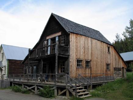
Chee Kung Tong Building National Historic Site of Canada
Barkerville, British Columbia
Located in British Columbia's Barkerville Historic Town Provincial
Historic Site, the Chee Kung Tong Building National Historic Site of
Canada is nestled in the Cariboo District mountains at an elevation of
1,280.2 metres (4,200 feet). Consisting of a two-storey rectangular
structure covered with board and batten, and flanked on the east and
north by two log lean-tos, the Chee Kung Tong building is situated on
the east side of the principal road, in the centre of Barkerville
Chinatown.
Among the oldest surviving structures in the Barkerville Provincial
Park, the main structure of the Chee Kung Tong building was constructed
between 1874-1877, and was originally used by the members of the Chee
Kung Tong organization for ceremonial, residential and social purposes.
The division of the interior into a hostel, kitchen and socializing
space on the ground floor, and a society hall and altar room on the
second floor makes this building an excellent and well-preserved example
of 19th-century architecture of the Chee Kung Tong in Canada, and a
representative of the organization's structures during the wooden
boomtown period of Chinatown architecture in British Columbia. As a
benevolent association, the Chee Kung Tong in Barkerville provided a
hostel for recent arrivals and winterers, provided venues for day-to-day
social activities, and coordinated traditional Chinese and Hong-men
celebrations that galvanized the sense of community. The Chee Kung Tong
in Barkerville was active in the social, political, economic and
recreational aspects of its members' lives, and the society exerted its
political control over the Hong-men through meetings which took place in
the society hall on the second storey of the Chee Kong Tong
building.
|

©Parks Canada Agency / Agence Parcs Canada, Adam Roth, 2010
©Parks Canada Agency / Agence Parcs Canada, Michael Prochazka, 2009
©Parks Canada Agency / Agence Parcs Canada, Michael Prochazka, 2009 |
Chilkoot Trail National Historic Site of Canada
Chilkoot, British Columbia
Transportation route to Klondike gold fields.
The Chilkoot Trail National Historic Site of Canada is a traditional
transportation route through rugged mountain terrain, connecting the
upper Yukon River in British Columbia with the Pacific Coast on the
Taiya Inlet in Alaska. It is best known as the route used by thousands
of prospectors on their way to the Yukon gold fields during the gold
rush of 1897-1900.
Chilkoot Trail was designated a national historic site of Canada in 1967
because of the role it played in the mass movement of people to the
Yukon during the Klondike Gold Rush.
The heritage value of the Chilkoot Trail lies in its association with
the Yukon gold rush of 1897-1900 as illustrated by the relict cultural
landscape. The trail, established and long used as a trade and travel
route by First Nation people, was part of a larger network of trails and
river routes used to reach the Klondike gold fields of the Yukon
Territory.
|

©Parks Canada Agency / Agence Parcs Canada, 2001 |
Chilliwack City Hall National Historic Site of Canada
Chilliwack, British Columbia
Chilliwack City Hall is small but beautifully detailed building designed
in the classical Beaux-Arts style and occupying a prominent corner site
in downtown Chilliwack, British Columbia. The building occupies a site
containing mature landscape features and a cenotaph commemorating the
community's fallen soldiers.
Designed by noted west coast architect Thomas Hooper, the building
originally housed police and courtroom facilities in addition to council
chambers and civic administrative offices. The building remains a vital
heritage landmark within the city, although ceased to function as the
municipal building in 1980. It currently houses the Chilliwack Museum.
The mature landscaping and war memorial park at the rear of the building
underscore its long-standing importance to the citizens of
Chilliwack.
|
©Parks Canada Agency / Agence Parcs Canada, 2000. |
Chinese Cemetery at Harling Point National Historic Site of Canada
Oak Bay, British Columbia
The Chinese Cemetery at Harling Point National Historic Site of Canada
occupies a 3.5 acre site that gently slopes in a south-westerly
direction to the shore of the Strait of Juan de Fuca. The burial area is
an open grass-covered field containing tightly-spaced rows of individual
graves, most of which run parallel to the waterfront, and 13 mass
graves. Three hundred of the graves are marked by head stones, while two
incinerator towers and an altar platform serve as visual and ceremonial
focal points within the cemetery. The absence of landscape features such
as trees, ornamental shrubs and lanes or pathways running in straight
lines respect the feng shui principles which are central to traditional
Chinese spiritual beliefs.
The cemetery was established in 1903 by the Chinese Consolidated
Benevolent Association which continues to own and maintain the site. It
remained in active use for private burials until 1950 and was formally
closed in 1961 with the interment of the remains of 849 Chinese pioneers
whose return to China had been blocked since 1937. At that time the
cemetery became a memorial site in honour of Chinese-Canadian
pioneers.
|
©Parks Canada Agency / Agence Parcs Canada, Janet Wright, 1994 |
Christ Church National Historic Site of Canada
Hope, British Columbia
The Christ Church National Historic Site of Canada is a modest,
beautifully crafted wooden structure designed in the Gothic Revival
style located in the town of Hope, British Columbia. The building's
design is composed of clearly distinguishable nave and chancel sections
and a side entrance porch, all covered with gable roofs. The exterior is
clad with clapboard siding and displays square-headed windows and a
Gothic style doorway. The building's historic character is enhanced by
its beautiful setting on a large, well-maintained lot surrounded by
mature fir trees.
Associated with the Church of England, the ecclesiological Gothic
Revival architectural movement called for a return to more traditional
forms of church design, rooted in English architecture of the Middle
Ages. Features, such as the side entrance with a Gothic style doorway, a
bell tower, and clear separation of nave and chancel in visibly distinct
building volumes, were characteristic of this style. Inside, the
separation of the nave from the chancel was reinforced by the use of a
chancel rail and by elevating the chancel three steps above the
nave.
Christ Church was one of approximately 14 similar Anglican churches
built in British Columbia between 1859 and 1866 under the direction of
Bishop George Hills and executed under the auspices of the Corps of
Royal Engineers stationed in British Columbia at the height of the Gold
Rush era. The construction of these churches was a part of a concerted
plan to establish British institutions in the new colonies of Vancouver
Island and Mainland British Columbia. At Christ Church, these objectives
were clearly expressed through the high quality of construction and
strict adherence to "high church" standards of design, demanded by
Bishop Hills and provided by the Royal Engineers and local builders.
Christ Church is one of the oldest-surviving and best-preserved churches
in western Canada.
|

©Parks Canada Agency / Agence Parcs Canada, 1991 |
Church of Our Lord National Historic Site of Canada
Victoria, British Columbia
The Church of Our Lord National Historic Site of Canada is an important
architectural landmark located in the heart of Victoria, British
Colombia. The building's exterior incorporates design elements from
traditional Gothic style buildings of brick and stone, all skillfully
adapted to wood construction. A roof-top spire, corner pinnacles, and
board and batten siding, all crafted from California redwood, convey a
sense of verticality to the design. Inside, a Gothic hammer beam truss
system spans the nave, offering an unbroken view of the apse and pulpit.
In 1913 an annex was added to the south side of the church.
Following a dramatic schism within the city's Anglican diocese, the
Reverend Edward Cridge had the Church of Our Lord designed by noted
pioneer West Coast architect John Teague, and constructed in 1875 by
builders Haywood and Jenkinson for the Reformed Episcopal Church in
Victoria . The building's Gothic Revival character was enhanced by
exploiting the advantages of board and batten siding, which reinforced
the vertical thrust of its gabled roof, pinnacles and roof-top spire.
The church interior includes a fine example of hammer beam vaulting.
Famed regional architect Samuel Maclure designed a complementary 1913
church annex known as the Cridge Memorial Hall.
|

©Parks Canada Agency / Agence Parcs Canada, 1983 |
Church of the Holy Cross National Historic Site of Canada
Skookumchuck Hot Springs, British Columbia
The Church of the Holy Cross Facing is a remarkable and picturesque
interpretation of the Gothic Revival style in wood built by and for
members of the Skookumchuk First Nation community. Situated in the
village of Skatin (Skookumchuk), the church is sited in the very heart
of the community and oriented towards the Lillooet River. The front
façade features three, slender, eight-sided spires rising from wooden
slatted bell stages. The church is comprised of the main worship hall
and a lean-to vestry at the east end of the building. The walls of the
worship hall, church office and towers comprise horizontal, overlapping
wooden white-painted siding on a wooden frame. The roof and spires are
covered with plain and decorative cedar shingles.
The Church of the Holy Cross was designated a National Historic Site of
Canada in 1981 as a fine example of a Gothic Revival Style mission
church.
The building is an impressive church in the Gothic Revival style,
rendered in wood and located in an isolated area of British Columbia.
Its distinctive profile, including its three gothic revival spires,
makes it an instantly recognizable landmark for the First Nation and
other residents of the province. Historically, the church was one of
many mission churches built by the Oblates of Mary Immaculate, a Roman
Catholic order that established missions in many aboriginal communities
across western Canada in the late 19th and early 20th centuries. The
church has been a symbol of the community that has served as a welcoming
spiritual centre for the Skatin people and others of the Stl'atl'imx
Nation for the last century.
The craftsmanship evident in the church's construction is testimony to
the skill of its builders. The worship hall contains a highly decorated
altar at the North/east end, backed by an elaborate carved screen
(reredos). The ceiling above the altar area (chancel) steps down to a
pointed vault and two semi-circular side vaults, giving visual
importance to the altar screen and the side altars on either side. The
church also possesses a beautifully carved wooden dove that was
originally suspended above the area reserved for the host. A low
communion rail separates the chancel both physically and spiritually
from the nave featuring burgundy-painted wooden bench pews with carved
ends that laid out on either side a central aisle. Two unpainted carved
wooden confessionals are located at the back of the hall and two flights
of wooden steps located at each corner lead to a balcony for the choir
with seating of similar design to that already described and a
decorative painted fretwork handrail. Although the details reflect the
influence of the Gothic Revival style, there are subtle and
complementary departures from that style reflecting a mixture of
European and First Nations design motifs evident in the cross and arches
of the tabernacle, the beak-like ends to the lobes of the fleur-de-lis,
the turned and reeded post, and the shaping of the base on the pew
ends.
|

©Parks Canada Agency / Agence Parcs Canada, J. Butterill, 1994 |
Congregation Emanu-El National Historic Site of Canada
Victoria, British Columbia
The Congregation Emanu-el Temple National Historic Site of Canada is a
two-storey red brick building located on a prominent intersection in
downtown Victoria, British Columbia. Built in 1863, the synagogue is
distinguished by its well-preserved Romanesque Revival exterior and its
interior detailing. Its setback of approximately two metres from the
sidewalk on both street fronts helps differentiate the synagogue from
neighbouring commercial and office buildings.
The building was constructed just five years after the arrival of the
first Jewish settlers in British Columbia in 1858. Although small in
size, Victoria's Jewish community played active and dynamic roles in the
economic, cultural and political life of the young city and the colony.
When completed in 1863, the synagogue was an impressive addition to the
city's skyline and an assertion of the commitment of this small but
significant cultural community to the future of British
Columbia.
The synagogue's design, provided by prominent west coast architect John
Wright, utilized Romanesque Revival forms often chosen in the 19th
century by the Jewish people as an appropriate expression of their
culture and spirituality. Once common throughout Europe and North
America, few Romanesque Revival style synagogues now survive. As the
oldest synagogue building in the country, Congregation Emanu-el Temple
is of outstanding value as a rare and well-preserved link to that design
tradition, and for its associations with the history and traditions of
Canada's early Jewish communities.
|
©Parks Canada Agency / Agence Parcs Canada, J. Butterill, 1994 |
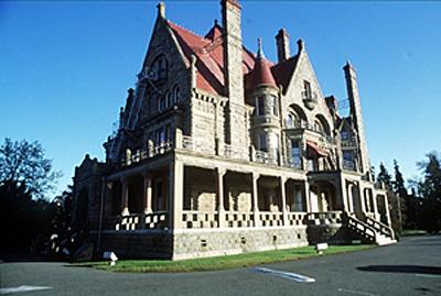
Craigdarroch Castle National Historic Site of Canada
Victoria, British Columbia
Situated on the summit of the highest hill adjacent to downtown
Victoria, British Columbia, Craigdarroch National Historic Site of
Canada is a well-known and prominent landmark. Its Scottish Baronial
design combines an eclectic fusion of elements borrowed from various
architectural styles to evoke the romantic image of a hilltop castle.
Built between 1887 and 1890, the castle is distinguished by its
distinctive combination of materials, asymmetrical massing with a strong
vertical emphasis, steeply-pitched picturesque roofline, and rich
contrast of materials, colours and details. The building occupies a
remnant of the original 11-hectare (28 acres) Dunsmuir estate and
dominates the surrounding Rockland residential area of Victoria.
Occupying a hill overlooking downtown Victoria, Craigdarroch's dramatic
profile was purposefully designed to assert the wealth and social
stature of its original owner, Robert Dunsmuir, a wealthy industrialist
who had amassed his fortune from Vancouver Island coal. Craigdarroch
epitomizes the "bonanza castle," a term used to describe oversized
mansions built as symbols of success for wealthy North American
industrialists during the late 19th and early 20th centuries.
No expense was spared to ensure that Craigdarroch was the largest, most
elaborate mansion in western Canada. Architect Warren H. Williams
combined elements from a variety of architectural styles to create a
dramatic design that was intended to evoke the impression of a castle
from Dunsmuir's native Scotland. The high level of craftsmanship evident
in the exterior masonry and detailing is also evident in the wall and
floor surfaces, stained glass, and joinery found throughout the
interior. The combination of native and imported materials—British
Columbia sandstone and granite, locally manufactured wrought iron,
Italian marble and Vermont slate, terracotta tile from California, and
imported interior wood panelling—was unprecedented in western Canada at
the time, and established new standards for opulence within the region.
Craigdarroch is one of the earliest, most flamboyant and best preserved
of the bonanza castles built in Canada.
Craigdarroch subsequently housed the Craigdarroch Military Hospital
(1919-21), Victoria College (1920-1946) and the Victoria Conservatory of
Music (1968-79). It is now operated as a house museum.
|
©Parks Canada Agency / Agence Parcs Canada |
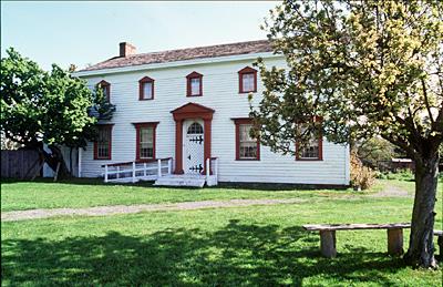
Craigflower Manor House National Historic Site of Canada
View Royal, British Columbia
The Craigflower Manor House was built between 1853 and 1856, mainly from
materials cut, hewn and milled in the vicinity. It is a two-storey
timber frame building with a moderately-pitched gable roof, end
chimneys, and a classically-inspired symmetrical five-bay plan with a
pedimented central entrance. The manor house occupies a parcel of land
overlooking the Gorge Waterway in the Greater Victoria district.
Craigflower Manor House was designated a national historic site in 1964.
Built for the Puget's Sound Agricultural Company, it is a fine example
of early domestic architecture in Western Canada.
As the residence of bailiff Kenneth MacKenzie, it was the focus of
Craigflower Farm, the oldest of four farms on Vancouver Island whose
employment of colonists marked the transition from fur trade to
settlement on the northwest coast. This transitional stage is reflected
vividly in the design of the Manor House, which combines Hudson's Bay
Company construction systems with Scottish architectural influences and
craftsmanship adapted to the use of local materials.
|
©Parks Canada Agency / Agence Parcs Canada, 1994 |
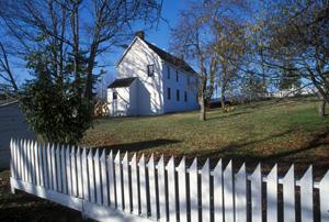
Craigflower Schoolhouse National Historic Site of Canada
View Royal, British Columbia
The Craigflower Schoolhouse National Historic Site of Canada is a
two-storey timber-framed building located on the north bank of the Gorge
Estuary in the greater Victoria area. Built in 1854-1855, to meet the
educational needs of children at Craigflower Farm, the building's five
bay plan, gable roof, Georgian proportions and white clapboard exterior
echo the form and design of the nearby Craigflower Manor House National
Historic Site of Canada. The schoolhouse is a conspicuously sited
historical landmark.
The Craigflower Schoolhouse was constructed with lumber obtained from a
steam-powered sawmill at the Hudson's Bay Company's Craigflower Farm.
Designed with a schoolroom and accommodation for the teacher and his
family on the main floor and several rooms for boarders on the second
floor, it served children from the farm and nearby settlements. The
building was also used for church meetings and public gatherings. After
the schoolhouse ceased operations in 1911, the building quickly fell
into disrepair. In 1927, it was acquired and restored by the Native Sons
and Native Daughters of British Columbia and preserved as a museum. Its
well-preserved interior and exterior illustrate architectural and
construction practices associated with the transition from fur trade to
settlement on the West Coast, and convey the importance attached to
education during the early stages of European settlement in Western
Canada.
|

©Parks Canada Agency / Agence Parcs Canada, Andrew Waldron, 2008 |
Dominion Astrophysical Observatory National Historic Site of Canada
Saanich, British Columbia
Dominion Astrophysical Observatory National Historic Site of Canada
(B.C.) is located at the top of a hill, 227 metres above sea level in
Saanich, British Columbia. The observatory, built from 1914 to 1918, is
a cylindrical structure 20.2 metres in diameter and 22.3 metres high
that is topped by a domed roof with two arched slats that open to allow
the telescope to focus on the night sky. The distinguished two-storey
steel frame building is clad in painted white metal panels, and features
classically inspired architectural embellishments such as pilasters,
stringcourses, and arches.
The Dominion Astrophysical Observatory (B.C.) (DAO) was built following
new developments in reflecting telescope technology during the early
20th century. In 1914 Canadian astronomer and the first DAO director,
John S. Plaskett, designated a National Historic Person of Canada,
successfully lobbied the federal government for funding to build a new
observatory with a very powerful reflecting telescope. From the time of
its completion in 1918 until the 1960s it was one of the world's main
astrophysical research centres.
Many discoveries were made using the observatory's 1.83-metre reflecting
telescope and spectroscopes at DOA. The most important early work was
the identification and classification of higher temperature stars. In
1922, Plaskett discovered a spectroscopic binary that was four times
larger than any previously discovered. During the 1920s and 1930s, the
DAO also produced in-depth studies on the nature of star evolution and
motions in space, which notably added to the understanding of the
rotation of the Milky Way and how stars age. Much of the DAO's work was
focussed on specific classes of stars, for which the observatory and
Canadian astronomers received international attention.
The DAO was constructed using the world's most advanced design for an
observatory in the early 20th century. The 1.83-metre telescope,
remarkable for its accuracy, clarity of optical lenses and
spectroscopes, was a major engineering accomplishment and briefly the
largest in the world. The focal ratio of the telescope was ideal for the
stellar spectroscopy at the Observatory, and its asymmetrical mount gave
it access to most of the sky, the first of this type for a reflecting
telescope. Electrical drives were avoided in favour of precise and
traditional mechanical movement with roller ball bearings, allowing for
a more reasonable cost without losing precision.
|

©Parks Canada Agency / Agence Parcs Canada, 1994 |
Doukhobor Suspension Bridge National Historic Site of Canada
Castlegar, British Columbia
The Doukhobor Suspension Bridge spans the Kootenay River a short
distance upstream from its confluence with the Columbia River in the
West Kootenay region of British Columbia. Built as a community effort,
the structure is comprised of reinforced concrete towers that rise to a
height of 14.6 metres (48 feet) and rest on concrete piers embedded in
the rock face on opposite banks of the river. The two towers support
four steel wire cables that are attached at both ends to steel sockets
anchored in the rock face. The bridge deck linking the towers is 100.9
metres (331 feet) in length and is suspended from the overhead cables by
vertical steel rods. The deck frame is constructed of structural steel
covered by wooden planks, stringers and surface decking. The wood
decking is now badly deteriorated, and approach ramps to the bridge have
been removed to prevent access.
The Doukhobor Suspension Bridge provided a vital road link between the
Doukhorbor communities of Brilliant and Ootenshenie on opposite sides of
the Kootenay River. Its construction was undertaken by members of this
utopian community who volunteered their labour at the behest of their
leader, Peter Vasilevich Verigin. Using traditional hand labour
techniques, the workers undertook the challenging tasks of forming and
pouring the piers and towers in the recently introduced medium of
reinforced concrete, then assembling and installing the massive cables
and steel decking. Begun in April 1913 and completed just 8 months
later, the Doukhobor Suspension Bridge was largely financed by the
Doukhobor community and played an important role in the cultural and
economic growth of this distinctive self-supporting communal society and
of the West Kootenay region for over 50 years.
|
©Parks Canada Agency / Agence Parcs Canada |
Emily Carr House National Historic Site of Canada
Victoria, British Columbia
Emily Carr House National Historic Site of Canada is a two-storey
Picturesque-Italianate style house located on a residential lot in the
James Bay district of Victoria, British Columbia, which was the
childhood home of artist Emily Carr.
Emily Carr (1871-1945), one of Canada's most famous painters and a
well-known author, lived most of her life in this neighbourhood of
Victoria. Built for her father, Richard Carr, the house and its environs
had a profound impact on Emily Carr's formative years, as she
acknowledged in her books. It was here that her desire to create and her
appreciation of art were kindled. The location of the house is
significant because of its proximity to Beacon Hill Park and to the
ocean shoreline, which played important roles in shaping Carr's lifelong
appreciation of the natural environment and her unique vision of coastal
British Columbia.
The house is an excellent and well-preserved example of a Picturesque
Italianate villa designed by John Wright (firm Wright and Sanders), a
prominent early West Coast architect.
|
©Parks Canada Agency / Agence Parcs Canada, 1991 |
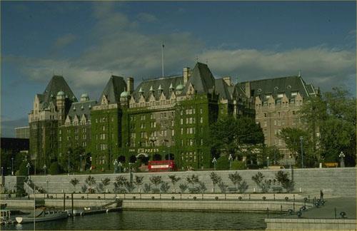
Empress Hotel National Historic Site of Canada
Victoria, British Columbia
The Empress Hotel is an early-20th-century stone hotel, constructed in
the Chateau style. It is prominently located at the head of the inner
harbour in the city of Victoria.
The Empress Hotel was designated a national historic site in 1980
because it is a Chateau-style hotel of national significance as an
architectural type.
Built for the Canadian Pacific Railway (CPR), the Empress Hotel is one
of a series of Chateau-style hotels built by Canadian railway companies
in the early 20th century to encourage tourists to travel their
transcontinental routes. Popular with the travelling public for their
elaborate decor and comfortable elegance, these hotels quickly became
national symbols of quality accommodation. The Chateau-style vocabulary
used by the railway hotels evolved as a distinctly Canadian
architectural type. The Empress signals the beginning of this evolution
from a strictly Chateau-style design towards one that incorporated
contemporary forms. Built in 1904-08 to designs by Francis M.
Rattenbury, the Empress was enlarged in 1910-12 to designs by W.S.
Painter and in 1928 to designs by J.W. Orrock.
|

©Parks Canada Agency / Agence Parcs Canada, Mills Photo No. 2, 1991 |
Esquimalt and Nanaimo Railway Roundhouse National Historic Site of Canada
Victoria, British Columbia
Designed in 1912 and completed in October 1913, the Esquimalt and
Nanaimo Railway Roundhouse is located in Victoria, British Columbia. The
site is comprised of three sections: the locomotive roundhouse and two
attached structures that housed various shop facilities for the
servicing of steam locomotives. The roundhouse building was built to a
segmental-arced plan and features a curved front and rear wall
constructed of solid red brick. It contains ten stalls that face onto an
operational turntable with an 85-foot diameter. The machine shop is a
rectangular brick building that abuts the rear southeast corner of the
roundhouse. The roundhouse complex is surrounded by associated site
features, notably the turntable, sidings and tracks, and two
freestanding brick buildings which are components of the industrial
complex and are contemporary to the roundhouse.
The Esquimalt and Nanaimo Railway roundhouse was designated a national
historic site of Canada in 1992 because it survives virtually untouched
since its construction in 1912. Surrounded by various well-preserved
related shops and railway outbuildings, it is a particularly fine
example of an industrial structure associated with the steam railway era
in Canada.
The Esquimalt and Nanaimo roundhouse is located on the site of the
original 1886 railway terminus for Victoria. This industrial complex was
built by the Canadian Pacific Railway to serve as the primary servicing
facility for the steam locomotives and rolling stock of the Esquimalt
and Nanaimo Railway. The facility served this purpose until 1949 when
steam locomotives were replaced by diesels on the island. After that
date the roundhouse served as a service facility for the E & N's
diesels, and currently services the passenger dayliners used by the
railway. Remarkably, the roundhouse and contemporary shops have survived
with minimal alterations since the time of their construction.
The roundhouse complex, consisting of the roundhouse itself, the
attached machine shed, the roundtable and the approach tracks, conveys a
clear sense of its functional purpose in its structure and
organizational layout. The roundhouse itself curves around the turntable
and features ten large openings creating ten work bays for the repair of
the locomotives. The large windows at the rear of the building provided
natural light into each of the 10 work bays. The machine shop is
attached to the rear of the roundhouse and cars could be moved into the
building through the roundhouse or by a separate track leading off the
turntable. The machine shop is divided internally into two sections by a
brick partition wall. The rear area was built to house a blacksmith shop
and boiler shop.
A distinct sense of place is conveyed by the uniformity of materials,
fenestration, building configuration, and by presence of the turntable
that links the entire complex of buildings into an efficient industrial
plant. The Esquimalt and Nanaimo roundhouse complex is the most intact
facility associated with the servicing of steam locomotives in western
Canada.
|
©Parks Canada Agency / Agence Parcs Canada, 2001 |
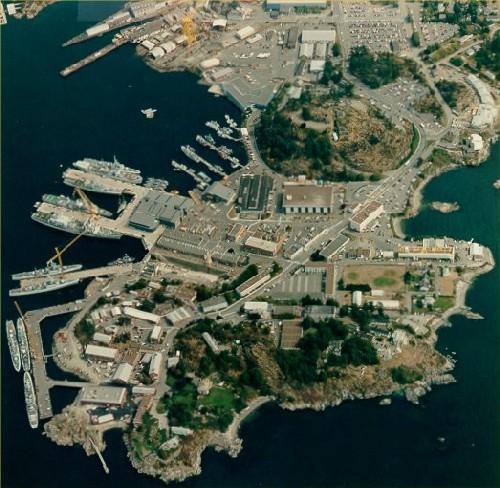
Esquimalt Naval Sites National Historic Site of Canada
Esquimalt, British Columbia
Esquimalt Naval Sites National Historic Site of Canada is a historic
district that incorporates four important naval station sites forming a
ring around Esquimalt harbour, British Columbia. These are Her Majesty's
Canadian (HMC) Dockyard, the former Royal Navy Hospital, the Veterans'
Cemetery and the Cole Island Magazine.
The heritage value of Esquimalt Naval Sites National Historic Site of
Canada lies in the range and richness of the naval history illustrated
by the site, setting, and the built and landscaped forms of the four
components. While each has value as a homogenous grouping with a
distinctive sense of place, together their distinctive design, forms,
materials, functional priorities and technologies reflect a complete and
legible record of the development of Canada's Pacific naval experience.
HMC Dockyard was established by the British Royal Navy in 1865 and has,
since then, been the heart of Canadian Forces Base (CFB) Esquimalt.
Today it has two major sub-areas: the 12 hectares (30 acres) developed
by the British Royal Navy before 1906, and a second section developed by
the Royal Canadian Navy during the Second World War era and consistently
expanded and rebuilt by the Department of Public Works and the Royal
Canadian Navy. The other components in this historic district include
the former Royal Navy Hospital (built 1860s, rebuilt 1887-1901, 1929),
the Veterans' Cemetery (established in 1868, expanded 1901, 1960s), and
the Cole Island Magazine (established 1859, expanded 1887-1904, retired
1938).
|

©Parks Canada Agency / Agence Parcs Canada, N. Clerk, 2002 |
Estate of the Lieutenant Governor of British Columbia National Historic Site of Canada
Victoria, British Columbia
The Estate of the Lieutenant Governor is an evolving cultural landscape
of some 14.6 hectare situated on a height of land known as the Rockland
Escarpment in a residential area of Victoria with commanding views of
the Strait of Juan de Fuca. The site contains a mosaic of varied
landscapes that includes 5.7 hectares of gardens, agricultural lands, a
mature stand of Douglas fir, and an extensive Garry oak ecosystem. The
site also contains the official residence built in 1957-59 following a
fire that destroyed its predecessor, a group of five service buildings
known as the Mews constructed between 1872 and 1903, a former gardener's
cottage (1903), and a former chauffeur's cottage (1929).
The present residence, built in 1957-59, is the third official residence
to occupy the site. It sustains the building-site relationship of its
predecessors through its placement, modified Tudor Revival style
elements and the retention of the porte-cochere from the previous
residence destroyed by fire. The grounds of the estate, originally laid
out in the early 20th century to a plan inspired by the great English
estates of the Edwardian era, contains an array of ornamental gardens
that have evolved over time. The rich mosaic of picturesque, pastoral
and natural landscapes lends a distinctive quality to an estate that is
a notable part of the history of British Columbia.
|

©Bibliothèque et Archives Canada / Library and Archives Canada, C-003131

©Bibliothèque et Archives Canada / Library and Archives Canada, C-003133 |
First Crossing of North America National Historic Site of Canada
Bella Coola, British Columbia
First Crossing of North America National Historic Site of Canada is
located in Sir Alexander Mackenzie Provincial Park, approximately 65
kilometres northwest of Bella Coola on the central coast of British
Columbia. The site consists of a rocky promontory jutting into Dean
Channel near the mouth of Elcho Harbour where Alexander Mackenzie of the
North West Company marked the westernmost part of his 1793 journey. A
Historic Sites and Monuments Board of Canada (HSMBC) monument was
erected above the rock in 1926 to commemorate the site.
On May 9, 1793, Alexander Mackenzie of the North West Company set out
from Fort Fork on the Peace River, near Fort Chipewyan, in search of the
Pacific Ocean. He and his party canoed up the Parsnip River to its
headwaters before moving overland to the upper Fraser River. Convinced
that the Fraser was unnavigable, they backtracked to the West Road River
and proceeded up its valley on foot. On July 19th they reached an
Aboriginal settlement at Bella Coola and two days later they reached
their destination, a rocky promontory where Mackenzie and his party
spent the night of July 22, 1793. Mackenzie recorded his position and
painted the following message on the southeast face of a large rock with
grease and vermilion "Alexander Mackenzie, from Canada, by land, the
twenty-second of July, one thousand seven hundred and ninety-three." By
August 24th the party was back at Fort Chipewyan having been the first
men to cross the continent north of Mexico to the Pacific Ocean.
|
©Parks Canada Agency / Agence Parcs Canada, Ian Doull, 2011 |
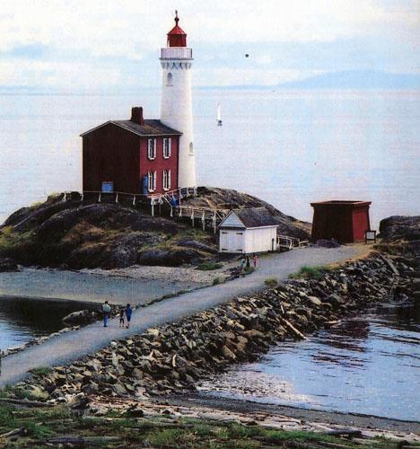
Fisgard Lighthouse National Historic Site of Canada
Colwood, British Columbia
First permanent lighthouse on Canada's West Coast, 1859-60.
Fisgard Lighthouse and its light keeper's residence comprises a
two-storey residence with attached cylindrical light-tower, located on
Fisgard Island on the east side of the entrance to Esquimault Harbour,
just north of Juan de Fuca Strait.
Fisgard Lighthouse was designated a national historic site in 1958
because it was the first permanent lighthouse on the Pacific Coast of
Canada.
Fisgard Lighthouse was built in 1859-60 by the British and Colonial
governments to mark the entrance to Esquimalt Harbour. It was designed
by Joseph Pemberton and John Wright of Victoria, and built by John
Wright and John J. Cochrane. It was in continuous operation until 1957
when a fire at the lighthouse temporarily halted its use as a
navigational aid. Once repaired, it became a national historic site and
has since been restored for public viewing. It remains in service as an
aid to navigation.
The heritage value of Fisgard Lighthouse lies in the strategic location
of the lighthouse, and the legibility and completeness of the tower,
lantern and house as a landmark on their island site.
|
©Parks Canada Agency / Agence Parcs Canada, 1991 |
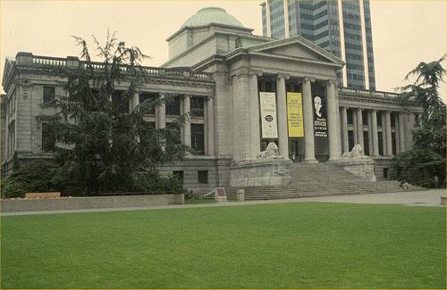
Former Vancouver Law Courts National Historic Site of Canada
Vancouver, British Columbia
The former Vancouver Law Courts building is an imposing stone structure
designed in the grand classical style. Situated on a city block bounded
by Georgia, Howe, Hornby and Robson Streets, it is a notable public
landmark located in the heart of Vancouver's business and commercial
core comprised of large office towers, hotels and retail complexes. It
now serves as the Vancouver Art Gallery.
The former Vancouver Law Courts was designated a national historic site
because it is an enduring visual landmark and symbol of justice and an
exemplar of its functional type.
As an example of a permanent building erected for the administration of
the law in British Columbia, this building illustrates the importance
Canadians attach to a strong judicial system. It also reflects
Vancouver's rapid growth, optimism and recognition that the city
required full judicial facilities beyond the New Westminster Judicial
District. The judicial district of Vancouver was created in 1892. By
1906, new court facilities were required after outgrowing two previous
structures rendered obsolete by the city's soaring population.
The former Law Courts building is a good example of Neoclassical design
in the Beaux-Art tradition, widely promoted for public buildings in
North America during the late 19th and early 20th centuries. The
building consists of a three-part composition with two wings faced with
inset Ionic columns flanking a massive projecting central pediment. The
latter features an imposing portico supported by four columns and
surmounted by a copper-clad dome on an elevated base. It was designed by
Francis Mawson Rattenbury (1867-1935), a noted Victoria architect who
was responsible for many prominent public buildings in British Columbia
including the Legislative Building in Victoria. The courthouse was
opened in the fall of 1911, at which time it was praised as the finest
building of its kind in Canada.
By 1914 the city had outgrown the original building and a large new wing
connected to the main building by an enclosed two-storey corridor was
added to the west side of the building according to the designs of
Thomas Hooper. By that time, Vancouver's population boom was halted by
an economic recession and the anticipated need for a second annex did
not materialize. For nearly half a century the building continued to
meet the city's judicial requirements but, by the 1970s, the building
could no longer accommodate the needs of the court and the decision was
made to construct new facilities. Trials were held in this building
until 1979, same year as the building's rehabilitation. Vancouver
architect, Arthur Erickson was commissioned to design the new Court
House located across the street and to convert the former Court House
into the Vancouver Art Gallery.
|
©Parks Canada Agency / Agence Parcs Canada, Andrew Waldron, 2011 |
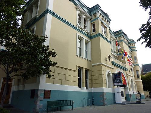
Former Victoria Law Courts National Historic Site of Canada
Victoria, British Columbia
Overlooking James Bay in Victoria, British Columbia, the Former Victoria
Law Courts National Historic Site of Canada is a rectangular three-story
building with a horizontal emphasis which was purpose built to house the
Supreme Court of British Columbia. The late 19th-centurty electic design
provides an interesting combination of various stylistic elements. With
an asymmetrical yet balanced composition and a flat roof, the building
features a lively synthesis including two interesting round corner
towers, heavy cornicing, prominent stringcourses, round arched windows,
and rustication of the ground floor. The building is a visual focal
point in the Bastion Square complex overlooking the waterfront area.
While the courts were relocated in 1962, the building has since been
converted and currently houses the Maritime Museum of British
Columbia.
Completed in 1889, the Former Victoria Law Courts marked an important
stage in the evolution of British Columbia's court system. It was the
first major public building built in British Columbia after
Confederation, and its construction ushered in a concerted phase of
courthouse construction throughout the entire province. Over the next
seven years, it was followed by a succession of brick or stone court
buildings in Vancouver, New Westminster, Vernon, and Nanaimo. However,
the building remained unique in its electic architectural style,
composed of various stylistic elements, resulting from the architect
Herman Otto Tiedeman's intentions to provide a functional building where
utilitarian considerations of the building took precedence over
aesthetics.
|

©British Columbia Archives / Archives de la Colombie Britannique, #F-05775 |
Fort Alexandria National Historic Site of Canada
Alexandria, British Columbia
Fort Alexandria National Historic Site of Canada is located on the west
side of the Fraser River near the community of Alexandria in the Cariboo
District of British Columbia. There are no known above ground remains of
the fort, which was established as a trading post by the North West
Company in 1821.
Alexander Mackenzie was the first European to visit present-day
Alexandria during his explorations. After arriving in 1793, he found a
First Nation village on the Fraser River whose inhabitants, likely
Secwepemc (Shushwap), discouraged him from going further north, citing
hostile Aboriginal groups. Mackenzie reversed his course, and European
explorers did not visit this area again for 30 years. In 1821, the North
West Company established a post on the Fraser River, naming it after
Alexander Mackenzie in recognition of his earlier visit to the area.
Fort Alexandria was the last post created before the North West
Company's merger with the Hudson's Bay Company later that year. The fort
was built as the northern terminus for the company's Pacific brigade
trail. After 1826, goods brought up the Columbia to Fort Okanagan were
sent overland by pack train to Fort Alexandria, before being distributed
by water to the post of New Caledonia. This process continued until road
transportation supplanted the brigade in the 1860's.
In the middle of the 19th century, gold was discovered in the Cariboo
district of British Colombia where Fort Alexandria was located. A trail
known as the Cariboo Road, or Cariboo Wagon Road, serving the
prospectors was completed to Alexandria in 1863. The modern descendant
of this road is the Cariboo Highway that runs close to the former site
of Fort Alexandria. By 1867, the fort had become a farm, which supplied
produce to the nearby community of Quesnel, as well as to miners heading
north to Barkerville. The Hudson's Bay Company relinquished the property
in 1881 and in 1915 the buildings were demolished.
|

©Parks Canada Agency / Agence Parcs Canada, 2008 |
Fort Hope National Historic Site of Canada
Hope, British Columbia
Fort Hope National Historic Site of Canada is situated in the Town of
Hope in southern British Columbia. In 1848-49 a Hudson's Bay post
surrounded by a stockade was constructed here facing the Fraser River.
There are now no known remaining resources associated with the site of
Fort Hope. Located at 211 Wallace Street the designated site occupies
0.6 hectares and currently comprises a small block of commercial
buildings and parking lots. The Historical Sites and Monuments Board of
Canada cairn commemorating Fort Hope stands a short distance from the
site on the bank of the Fraser River, at the corner of Wallace and
Walter Street.
Constructed as a trading post at Hope by the Hudson's Bay Company, Fort
Hope was one of the elements which opened a way into the interior of the
country through British territory. The heritage value of Fort Hope
National Historic Site of Canada resides in its historical associations
with Canada's economic development and contributing to the building of
international relations. When the boundary settlement of 1846 determined
that the mouth of the Columbia River would be American territory, the
Columbia River became impractical as a supply route for the Hudson's Bay
Company. The Hudson's Bay Company decided instead to bring the goods
from Langley up the Fraser River to the head of the navigation, where
Fort Hope was built in 1848-49. The fort was the point of transfer from
water to land on the "Brigade Trail" between Fort Langley and the posts
of the interior. From Fort Hope, the goods were sent by pack train to
Kamloops and then onwards to Alexandria for distribution by water to the
posts of New Caledonia, a district of the Hudson's Bay Company in
British Columbia. This complex system was used by the Hudson's Bay
Company until gold discoveries spawned road construction in the area
after 1860. Currently the site comprises a small block of commercial
buildings and parking lots serving local businesses and community
interests.
|
|
Fort Kamloops National Historic Site of Canada
Kamloops, British Columbia
In 1812 David Stuart, who had traversed this region the year before,
built the first post here for Astor's Pacific Fur Company. The North
West Company, which had also built here in 1812, bought out the
Astorians in 1813, and in 1821 the post passed to the Hudson's Bay
Company. Although it was commercially insignificant, Kamloops was
important because it lay astride the brigade route from the Columbia
Department to New Caledonia and because its rich grasslands enabled the
company to raise packhorses here. As provincial roads improved the post
became superfluous, and by 1885 had been abandoned.
|

©Parks Canada Agency / Agence Parcs Canada, J. Gordon, 2005
©Parks Canada Agency / Agence Parcs Canada, A. Cornellier, 1988 |
Fort Langley National Historic Site of Canada
Langley, British Columbia
Early 19th-century Hudson's Bay Company post.
Fort Langley National Historic Site of Canada is the site of a Hudson's
Bay Company post located on the south banks of the Fraser River
approximately 48 km east of Vancouver. It contains an original log
warehouse as well as several newer evocations of historic structures
within a reconstructed wooden palisade. The site is interpreted and open
to the public.
The heritage value of Fort Langley lies in its historical associations
as illustrated by the site and surviving resources. Originally
constructed in 1827 at a location 4 km upstream of its present site, the
post was relocated and rebuilt in 1839, only to be destroyed by fire in
1840 requiring it to be, once again, rebuilt. The Hudson's Bay Company
continued to run a post on this site until 1886, although in later years
its focus shifted from fur to agricultural trade and fish packing. Since
it became a national historic site in 1923 the location of Fort
Langley's palisades have been identified through archaeological
investigation, as have the remains of many of its buildings and
structures. The site has gone through two major periods of expansion;
firstly in the 1950s in conjunction with the provincial centennial
celebrations, and again in the 1990s.
|

©Parks Canada Agency / Agence Parcs Canada, Department of Mines and Technical Surveys (Natural Resources Canada), 1929 |
Fort McLeod National Historic Site of Canada
McLeod Lake, British Columbia
Fort McLeod National Historic Site of Canada is located on the west bank
of Pack River at the north end of McLeod Lake, British Columbia. The
site, set in the provincial heritage site, Fort McLeod Historic Park,
consists of a workshop, a house, and a warehouse, which are situated
within the fenced area of the fort. The small wooden buildings are
topped with gable roof, and are simply constructed.
By the early 19th century, the fur trade was expanding westward over the
Rocky Mountains to the Pacific Ocean, and the North West Company found
itself increasingly threatened by the Hudson's Bay Company and American
fur traders. As a result, in 1805, Simon Fraser of the North West
Company led an expedition westward from Fort William on Lake Superior to
secure the fur trade for the company on the west side of the Rocky
Mountains. This newly discovered area was named New Caledonia.
Fraser sent a group of men up the Pack River to build a stockaded log
fort at Trout Lake, which was later named Fort McLeod in honour of
Archibald Norman, a senior North West Company partner. Fort McLeod
became the base of the company's fur trading operations in New
Caledonia, and was the only liaison between the two sides of the Rocky
Mountains for two decades. After the amalgamation of the North West and
Hudson's Bay companies in 1821, the fort remained an active trading post
into the 20th century.
|

©Parks Canada Agency / Agence Parcs Canada J. Mattie, 1997 |
Fort Rodd Hill National Historic Site of Canada
Colwood, British Columbia
Late 19th-century fort to defend Victoria-Esquimalt
fortifications.
Fort Rodd Hill National Historic Site of Canada is a 19th and 20th
century coastal defence site strategically located on Esquimalt Harbour
near Victoria, British Columbia. It contains three artillery batteries
set within an open, park-like site, linked by an historic circulation
pattern. The site includes additional buildings and structures located
outside individual batteries. The fort is surrounded by natural forested
areas on the north and west, Esquimalt Harbour on the east, and the
Strait of Juan de Fuca to the south.
The heritage value of Fort Rodd Hill lies in the integrity and
legibility of its cultural landscape. Its strategic location and setting
as well as the layout, orientation, nature and composition of the many
defence structures it contains witness almost a century of change in
military design and requirements.
The British navy built temporary batteries at Macaulay Point in 1878 to
protect the port of Victoria and the Esquimalt naval harbour during the
Anglo-Russian crisis of that year. In the 1890s, Canada negotiated with
Great Britain for the construction of a series of permanent defences for
the Victoria-Esquimalt area, to be manned by British troops in defence
of the Empire. Construction began on Fort Rodd Hill in 1895 and Canada
assumed control of these fortifications in 1906, extensively enlarging
and rebuilding them by the end of the Second World War. They were
declared obsolete in 1956. The site was subsequently acquired by Parks
Canada.
|
©Parks Canada Agency / Agence Parcs Canada, D. Houston, 2003

©Parks Canada Agency / Agence Parcs Canada, D. Houston, 2003 |
Fort St. James National Historic Site of Canada
Fort St. James, British Columbia
Fur trade post founded by Simon Fraser, 1806; Hudson's Bay
Company.
Fort St. James National Historic Site of Canada is a former fur trade
post located in the village of Fort St. James at the southern tip of
Stuart Lake, British Columbia. It is a restored compound located beside
a lake between the Nak'azkli First Nations Reserve and the business
district of the village. The site includes buildings, archaeological
resources and reconstructed components.
The heritage value of Fort St. James National Historic Site lies in its
historical associations as illustrated by its siting and surviving
historical resources. Fort St. James was founded by the North West
Company to conduct trade with the Carrier First Nation and after 1821,
was operated by the Hudson's Bay Company. From 1826-1862 it was the
headquarters of the Hudson's Bay Company's New Caledonia District, while
in later years it served as base for transportation links to northern
British Columbia. Over this period, it occupied a loosely defined,
evolving site on the shore of Stuart Lake. The post closed in 1952, four
years after it had been declared a National Historic Site.
It was subsequently outfitted for public visitation, an activity that
included both restoration and reconstruction to the 1896 period. The
fort contains archaeological resources from the period 1806-1952 as well
as original buildings (the General Warehouse, 1888-89; Fish Cache, 1888;
the Men's House, 1884/85, 1888/89; Officer's Dwelling, 1884/85; and the
Dairy, present in 1896).
|
|
Fort St. John National Historic Site of Canada
Fort St. John, British Columbia
Following Mackenzie's explorations, the North West Company established
several trading posts between Dunvegan and Hudson Hope. Fort St. John,
built first in 1806 at the junction of the Peace and Beatton Rivers, was
later moved to various sites along the Peace. The post was taken over by
the Hudson's Bay Company in 1821 and after an Indian raid in 1823 was
abandoned for thirty-seven years. The most recent post, established in
1925, gave its name to the townsite of Fort St. John.
|

©Google Earth, 2009. |
Fort Steele National Historic Site of Canada
Fort Steele, British Columbia
Fort Steele National Historic Site of Canada, formerly known as Kootenay
Post, is located in the town of Fort Steele, British Colombia. The fort,
established in 1887 as the first North West Mounted Police post in
British Colombia, was strategically located on a bluff overlooking the
Kootenay River. There are no original buildings of Fort Steele remaining
on the site.
Fort Steele was established during the summer of 1887 as the first North
West Mounted Police (N.W.M.P.) post in British Columbia by
Superintendent Samuel B. "Sam" Steele. Originally called Kootenay Post,
the fort was established when the detachment ('D' Division) of the
N.W.M.P. was sent to the area to resolve a dispute between the local
Ktunaxa tribe and European settlers. The presence of Sam Steele and the
N.W.M.P. secured a peaceful solution and created order in the community,
leaving the area open for development. By July 1888, the detachment had
been sent on to Fort Macleod and Kootenay Post was abandoned. After Sam
Steele left the region, the citizens of Galbraith's Ferry renamed their
town Fort Steele in appreciation of Steele's work. By 1897, the town of
Fort Steele had expanded to include the site of Kootenay Post.
|
©Parks Canada Agency / Agence Parcs Canada, Andrew Waldron, 2011 |
Fort Victoria National Historic Site of Canada
Victoria, British Columbia
Fort Victoria National Historic Site of Canada is located on the
southern end of Vancouver Island in Victoria, British Columbia. Now
located in downtown Victoria at the intersection of Fort Street and
Government Street, the site was established by the Hudson's Bay Company
in 1843. The only extant remains of the 19th-century fort include the
palisade, two bastions and three mooring rings located west of the fort
site in Victoria Harbour, adjacent to Malahat Building / Old Victoria
Custom House National Historic Site of Canada.
The heritage value of Fort Victoria lies in its historical associations
with the Hudson's Bay Company (HBC) trade activities and its role as an
early political centre in British Columbia. In 1843, the Hudson's Bay
Company established Fort Victoria on the coast of James Bay, in what is
now the City of Victoria. The fort was constructed as a result of
American encroachment on British territory. Fearing that the United
States would assume control over the Oregon Territory and the lands to
the north, the British established the fort to lay visual claim to the
land. In 1846, the Oregon border was established at the 49th Parallel,
and the Victoria post became the grand depot and headquarters of the
HBC's pacific fur trade. Ships moored at Fort Victoria to unload
supplies for an extensive network of forts and to take on natural
products for export, principally to Alaska, California and
Hawaii.
In 1849, the first Legislative Assembly of the Colony of Vancouver met
at the fort, and the following year the Colony of Vancouver Island was
founded under governor Richard Blanshard, with Fort Victoria as its
capital. After a brief population boom in 1858 due to the Gold Rush, the
fort property was sold, the palisade was torn down and within a few
years, the last of the buildings were demolished.
|
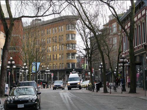
©Parks Canada Agency / Agence Parcs Canada, 2008 |
Gastown Historic District National Historic Site of Canada
Vancouver, British Columbia
Gastown Historic District National Historic Site of Canada is located on
the south side of Burrard Inlet in downtown Vancouver, British Columbia.
The district is positioned on a grid layout that follows the Inlet's
curvature. The 141 buildings within the site, built mostly between 1886
and 1914, comprise a homogeneous commercial district of three- to
six-storey stone and brick warehouses, commercial stores, hotels and
taverns. Masonry construction is seen throughout the site, with an
emphasis on solid brick and stone façades punctuated by regular window
openings above glassed-in storefronts.
Gastown Historic District began to develop in the late-19th century, on
the south side of Burrard Inlet in downtown Vancouver. Gastown was
constructed on a grid pattern that follows the Inlet's curvature on flat
land near sea level. The layout and location of the district reflects an
early period of Vancouver's development as an important and prosperous
transhipment point and wholesale district for goods transferred between
the Prairies and the Pacific Rim. The Canadian Pacific Railway (CPR),
set adjacent to the townsite, was responsible for the rapid development
and transformation of the townsite into a commercial district. Power and
telephone lines run along the laneways of the district instead of the
street, which is a typical example of Vancouver's early urban
development.
In the 1970s, the district went through a process of "beautification" in
response to the activist heritage movement that was emerging in Canada's
urban centres. Local organizations protected the historic fabric of the
district by adding historic elements to urban spaces. These include the
bollards along Water Street and around Maple Leaf Square, the bronze
statue of "Gassy" Jack Deighton, the landscaping features of Gaoler's
Mews, the red-brick paving on Water Street and the ornate lamp fixtures.
After the provincial government designated Gastown as a heritage area in
1971, the district gradually became distinct from surrounding
neighbourhoods on the downtown peninsula. The area is now characterized
by commercial and office space (with some live/work lofts interspersed),
many with shops and restaurants on the ground floors. Within the
district are approximately 141 buildings constructed before 1914. These
buildings range from two- to six-storeys, with details in a variety of
styles, ranging from the Victorian Italianate style of the late-19th
century buildings; the Victorian Romanesque Revival style used in the
early-20th century buildings, and the more austere, industrial style
used in the pre-First World War buildings. Only six buildings have been
constructed in the district since 1914.
|

©Parks Canada Agency / Agence Parcs Canada |
Gitwangak Battle Hill National Historic Site of Canada
Gitwangak, British Columbia
18th-century Gitwangak hilltop fortification surrounding five
longhouses, Tawdzep.
Gitwangak Battle Hill National Historic Site of Canada (formerly known
as Kitwanga Fort) is the remnants of a fortified village of the
Gitwangak people, located on the Kitwanga River among the Hazelton and
Buckley Mountain Ranges in central British Columbia.
The heritage value of Gitwangak Battle Hill lies in its associations
with Gitwangak history as illustrated by the site itself and the
archaeological resources discovered there. According to legend, the
warrior Nekt was the builder of Fort Kitwanga as a defensive stronghold.
Occupied from at least the 18th century, the fort comprised five
longhouses on top of the hill and enclosed by a palisade. Closely
connected to the main residential village of the Gitwangak, situated
over the hill for its protection, the fort was used by the Gitwangak
people as they raided settlements along the Skeena River and the coast.
It was burnt and abandoned about 1835.
|
©Parks Canada Agency / Agence Parcs Canada |
Glacier National Park of Canada
Headquarters: Revelstoke, British Columbia
British Columbia's lush interior rainforest and permanent
glaciers.
Glacier National Park protects, for all time, a portion of the Columbia
Mountains Natural Region, in the interior wet belt of British Columbia.
The steep, rugged mountains, warm, moist climate and wide variety of
plant and animal life are typical of this natural region. The park
protects unique stands of old-growth cedar and hemlock and critical
habitat for threatened and endangered wildlife species such as the
mountain caribou, mountain goat and grizzly bear. Rogers Pass National
Historic Site is located in Glacier National Park. Rogers Pass was so
designated for its importance in the construction and development of the
country's first major national transportation route.
|
©Parks Canada Agency / Agence Parcs Canada |
Gulf Islands National Park Reserve of Canada
Headquarters: Sidney, British Columbia
An exceptional coastal island landscape in the southern Strait of
Georgia.
Established in 2003, Gulf Islands National Park Reserve safeguards a
portion of British Columbia's beautiful southern Gulf Islands
archipelago. These islands are representative of the Strait of Georgia
Lowlands, one of the most ecologically at risk natural regions in
southern Canada. This small park reserve includes thirty-six square
kilometres of land and marine area on fifteen islands, numerous islets
and reefs which provide valuable habitat for seals and nesting
shorebirds. Additionally twenty-six square kilometres of submerged lands
are also administered for national park purpose.
|

©Parks Canada Agency / Agence Parcs Canada |
Gulf of Georgia Cannery National Historic Site of Canada
Richmond, British Columbia
Outstanding West Coast fish processing complex, 1894.
Gulf of Georgia Cannery National Historic Site of Canada is a large
complex of wooden buildings associated with fish processing and canning
built on wharf structure situated on the north bank of the south arm of
the Fraser River at the River's mouth on the Gulf of Georgia in the
village of Steveston. It is operated now as a historic site open to the
public.
The heritage value of the site is carried by the physical complex of
buildings constructed and modified between 1894 and 1964 and their
illustration of industrial fish processing and canning during the first
half of the twentieth century. Over the years, the cannery evolved into
a herring reduction plant and finally ceased functioning in 1979 when
the buildings were used as storage and a netloft facility until
purchased by the Government of Canada for operation as a national
historic site.
|
©Parks Canada Agency / Agence Parcs Canada |
Gwaii Haanas National Park Reserve, National Marine Conservation Area Reserve, and Haida Heritage Site
Headquarters: Queen Charlotte, British Columbia
Haïda culture and coastal rainforest on Queen Charlotte Islands.
Together, the Government of Canada and the Council of the Haida Nation
manage the special place called Gwaii Haanas. The name means "Islands of
Beauty" in the Haida langauge and the area embodies the rugged beauty
and rich ecology of this remote Pacific Coastal region. The Haida Gwaii
Watchmen work closely with Parks Canada to watch over important cultural
sites including the standing poles at SGang Gwaay, a UNESCO World
Heritage Site. Giant Sitka spruce, breeching humpback whales, waters
teaming with salmon and herring.
|
©Parks Canada Agency / Agence Parcs Canada |
Gwaii Haanas National Park Reserve, National Marine Conservation Area Reserve, and Haida Heritage Site
Headquarters: Queen Charlotte, British Columbia
Parks Canada has identified the waters around Gwaii Haanas National Park
Reserve and Haida Heritage Site as a potential national marine
conservation area reserve.
|

©Parks Canada Agency / Agence Parcs Canada, L. Maitland, 1995 |
Hatley Park / Former Royal Roads Military College National Historic Site of Canada
Colwood, British Columbia
Hatley Park is a 228.84 hectare estate situated on the edge of Esquimalt
Lagoon, with Hatley Castle, a Tudor Revival-style manor house, as the
centrepiece of an evolved Edwardian landscape that is comprised of four
zones: the gardens, the recreation spaces, agricultural lands and
forest. The estate also contains a variety of elements that reflect its
lengthy role as a military college and the evolving landscape of Hatley
Park. These include the adaptation of several auxiliary buildings to
classroom space and staff accommodation, as well as an overlay of
purpose-built structures, two sports fields and a parade square dating
from the 1940s to the mid-1970s.
Built in 1908-09 for James Dunsmuir, wealthy industrialist and
provincial politician, Hatley Castle is notable for its Tudor Revival
design by famed west coast architect Samual Maclure, and for its central
relationship to the Edwardian landscape devised by landscape architects
Brett and Hall. The Dunsmuir family lived here until 1937. In 1940 the
estate was purchased by the Department of National Defence to
accommodate Royal Roads Military College.
|
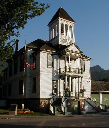
©Parks Canada Agency / Agence Parcs Canada, 2003 |
Kaslo Municipal Hall National Historic Site of Canada
Kaslo, British Columbia
Kaslo Municipal Hall National Historic Site of Canada is located in the
heart of the municipality of Kaslo, British Columbia. A two-storey, wood
frame building with a truncated hipped roof that rests on a rubble stone
and brick foundation, the building's design adopts a classical
vocabulary in its use of columns and pediments that were often
associated with public buildings in the late 19th century. A prominent
central entrance accessed by a double-curved staircase defines the main
elevation. The entrance is framed by a projecting portico, which rises
two storeys and is surmounted by a substantial belfry featuring open
arcades and a decorative base. These elements accentuate the verticality
of the building and convey a sense of dignity and importance that has
made it an enduring landmark within the community.
Built at the height of the great mining boom that transformed the
Kootenay region of British Columbia, and just five years after the
establishment of Kaslo as an important service, transportation and
administrative centre, this municipal hall symbolized the aspirations
and optimism of its citizens for the future of their community.
The Kaslo Municipal Hall was built to house the municipal council
chambers and administrative offices, the provincial court, the fire and
police departments, and the jail. Combining numerous functions under one
roof, this substantial building became an enduring landmark that
conveyed an air of progress and stability for the young municipality.
Designed by the architectural firm of Ewart and Carrie of Nelson,
British Columbia, the design demonstrates the architectural and
decorative potential of British Columbia wood, evident in the
classically inspired detailing around the windows, doors, cornice,
entrance portico, and belfry. The interior has undergone relatively few
changes since its construction and it provides an excellent example of
an important public building constructed of wood.
|
©Parks Canada Agency / Agence Parcs Canada |
Kicking Horse Pass National Historic Site of Canada
Yoho National Park, British Columbia
Traversed by Palliser expedition, 1857-60; adopted by Canadian Pacific
Railway as their new route through the Rockies, 1881.
Located in Banff and Yoho National Parks of Canada, the Kicking Horse
Pass National Historic Site of Canada is a major rail and highway
transportation corridor through the Rocky Mountains. The corridor is an
engineered landscape of rails, railbed, grades and curves, sidings,
snowsheds, tunnels, runaway sidings, rock cuts, remains of work camps
and other elements of construction. Some of the most spectacular
mountain scenery in the world frames this transportation corridor to
either side.
First recorded by the Palliser expedition of 1857-60, this pass takes
its name from an incident in which Dr. James Hector, surgeon to the
expedition, was kicked by his horse while exploring in this vicinity.
The pass was little used until after 1881 when the Canadian Pacific
Railway decided to adopt it as their new route through the Rockies,
foregoing the earlier preference for the more northerly Yellowhead Pass.
This decision altered the location of the line across western Canada and
dramatically affected the development of the West.
|

©Parks Canada Agency / Agence Parcs Canada, 1998 |
Kiix?in Village and Fortress National Historic Site of Canada
Barkley Sound, British Columbia
The scientific and historic value of the site lies in its rarity as the
only known First Nations village on the south coast of British Columbia
that has retained its integrity, as well as in its contribution to the
understanding of over 3000 years of continuous occupation. The main
village (DeSh 1) contains evidence of ten houses, eight of which have
traditional big house frames with timber posts, several having been
carved, and beams that either remain standing or have fallen to the
ground. The fortress site (DeSh-2) exhibits the outlines of five houses
located on three platforms at different elevations. A small midden (DeSh
24) and a larger one (DeSh 25) with the remains of three more houses
demonstrate continuous occupation of the area for almost 3,000 years,
with the most recent occupation being the post contact establishment of
Kiix?in Village and Fortress.
The natural features of the site made it an ideal location for
occupation and defence. The two sandy beaches were used as landing sites
for canoes, while the high rocky headlands provided a defensive
stronghold and commanding views of the surroundings. Natural resources
were abundant with intertidal and sub-tidal areas rich in invertebrates,
fish, birds, mammals and seaweed. As a strategically located village,
Kiix?in was central to coastal transportation, trade routes and shifting
alliances of the Huu-ay-aht from approximately 500 B.C.E. to the late
19th century. By the 1880s, the Nuu-chah-nulth had moved from the
village, but the site has remained important in the lives of its members
for food gathering as well as ceremonial and spiritual purposes.
|
©Parks Canada Agency / Agence Parcs Canada |
Kitselas Canyon National Historic Site of Canada
Kitselas, British Columbia
Located on the banks of the Skeena River on Kitselas Indian Reserve
Number One, Kitselas Canyon National Historic Site of Canada is a
dramatic natural setting richly endowed with significant cultural
resources, such as petroglyphs, totem poles, culturally modified trees,
and archaeological remains.
This location has been settled by Aboriginal peoples for approximately
5000 years. The Canyon is located in a strategic position between the
interior and the coast, and for that reason it played a pivotal role in
the west coast fur trade. The wealth of surviving material at this site
has provided unique and abundant insights into the cultural history of
the Canyon.
|
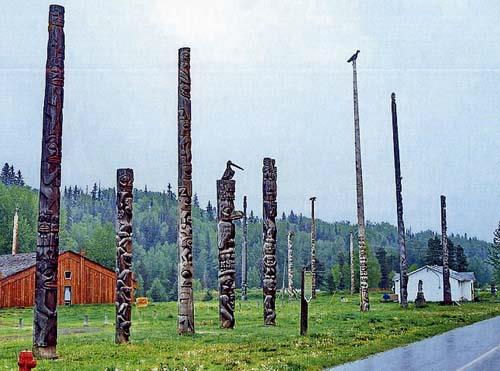
©Gregory Melle, Flickr, http://www.flickr.com/photos/canadagood/3452022259/, 2007 |
Kitwankul National Historic Site of Canada
Gitanyow, British Columbia
Kitwankul National Historic Site of Canada is located near the
confluence of Kitwankul Creek and the Kitwanka River, in Kitwankul
Indian Reserve 1, within the village of Gitanyow (formerly called
Kitwankul). It was the site of a traditional Tsimshian village,
featuring houses with traditionally painted exteriors, and monumental
art, much of which dated from the mid-to-late 19th century. At the time
of designation there were architectural remains including the footprints
of buildings, approximately 20 original totem poles, and a cemetery,
standing along a main road.
Kitwankul National Historic Site of Canada is the location of what was
one of the most culturally intact villages of the Gitksan (Gitxsan).
This Gitksan village is important for its surviving monumental art and
as a ceremonial centre shared by peoples of the Nass and Skeena Rivers.
The village played an important role in the Potlatch ceremony. Until ca.
1950 it could only be reached by the Old Grease Trail which ran between
the Nass and Skeena Rivers since pre-contact times, this difficult
access isolated it from modernization. Because of its position on the
trail it served as an intermediary between the Niskae and Gitksan, and
its inhabitants intermarried and potlatched with both groups. It had the
largest number of old poles of any Tsimshian village of which less than
twenty remain. Many of the poles date from the mid-to-late-19th century
and some to the early 20th century. Three poles were sent by the
villagers to the Provincial Museum of B.C. in Victoria about 1960 in
exchange for copies by Henry Hunt, a noted Kwakiutl carver. The copies
were re-erected in 1970 along with a provincial historic site plaque.
The remaining poles were restored and re-erected by the Skeena River
Totem Pole Preservation Society in 1968.
|

©Parks Canada Agency / Agence Parcs Canada |
Kootenae House National Historic Site of Canada
Invermere, British Columbia
Site of North West Company post, 1807-12.
Located just north of Invermere, British Columbia, Kootenae House
National Historic Site of Canada is an archaeological site at the
confluence of Toby Creek and the Columbia River. Some above ground
remains, as well as surface depressions, mark where this trading fort
once stood. The open grasslands, stands of Douglas Fir, and defensible
terrace over the water evoke the qualities of the landscape at the time
that Kootenae House stood on this location.
In 1806 the North West Company clerk, Jaco Finlay, blazed a trail over
Howse Pass from the Saskatchewan to the Columbia River. The next year,
David Thompson followed this route to the Columbia, then turned up river
and built Kootenae House below Windermere Lake in order to trade with
the Ktunaxa (Kootenay) people. Using this fort as a base, he explored
the upper Columbia and Kootenay rivers, and established a chain of posts
on the Columbia watershed. Kootenae House was used periodically until
1812, when the hostility of the Peigans east of the pass forced
abandonment. The land where Kootenae House stood was donated to the
Government of Canada by Mrs. Alice M. Hamilton in 1935 in honour of her
husband Basil G. Hamilton.
|
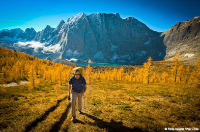
©Parks Canada Agency / Agence Parcs Canada, 2014 |
Kootenay National Park of Canada
Headquarters: Radium Hot Springs, British Columbia
UNESCO World Heritage Site featuring the famous Radium Hot
Springs.
Established in 1920, Kootenay National Park represents the south-western
region of the Canadian Rocky Mountains. From glacier-clad peaks along
the Continental Divide to the semi-arid grasslands of the Rocky Mountain
Trench, where cactus grows, this park is home to a rich diversity of
landscapes and ecology.
|
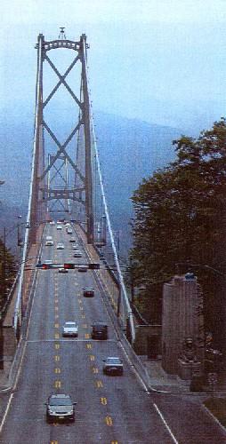
©Parks Canada Agency / Agence Parcs Canada, Judith Dufresne, 2003. |
Lions Gate Bridge National Historic Site of Canada
Vancouver, British Columbia
Located in Vancouver, the Lions Gate Bridge National Historic Site of
Canada is the longest suspension bridge in Western Canada with a total
length (including approach spans) of 1517 metres. The bridge has three
traffic lanes, an electronic signage system and a pedestrian and cyclist
sidewalk on either side of the deck. It serves as a major transportation
link for communities throughout the region on both sides of Burrard
Inlet. The site includes the south entrance to the bridge that emerges
from Stanley Park National Historic Site of Canada, near Prospect, the
main span, which is supported by twin towers, and the viaduct on the
north shore located in a land corridor that crosses Capilano Indian
Reserve.
Identified as one of Canada's technical and engineering landmarks, the
Lions Gate Bridge is noted for its innovative civil engineering. When
built it was recognized as the longest suspension bridge in the British
Empire and one of the biggest construction projects undertaken in Canada
during the 1930s. Despite its enormous size, the open steelwork of the
twin towers and pioneering use of a thin deck gave the structure a light
weightless quality that blend well with its picturesque setting. The
bridge was remarkable because of its length and the technical
innovations in cable use and construction. The reconstruction of its
deck at the turn of the twenty-first century was also an exceptional
achievement, marking the first time that the deck, hangers and
stiffening trusses of a suspension bridge were replaced simultaneously
without closing the bridge to traffic.
The bridge stimulated the geographic and socio-economic development of
the north shore of Vancouver. Financed by the brewing tycoon, Sir Arthur
Guinness, through a syndicate called British Pacific Properties Ltd.,
the Lions Gate Bridge was commissioned to open up the suburbs of West
Vancouver for development by establishing a direct link between
Vancouver and the north shore of the First Narrows of Burrard Inlet. The
design of the bridge owed much to the vision of Victoria-born Alfred
J.T. Taylor, a prominent engineering contractor and industrialist who
had substantial land holdings on the north shore and who assembled the
financing for the project.
Despite upgrades due to increased traffic flow and seismic concerns, the
integrity of its aesthetic design and the treatment of materials have
been maintained.
|
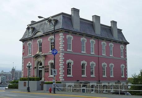
©Parks Canada Agency / Agence Parcs Canada, Andrew Waldron, 2011 |
Malahat Building / Old Victoria Custom House National Historic Site of Canada
Victoria, British Columbia
The Malahat Building/Old Victoria Custom House is a three-storey,
mansard-roofed, brick building, built in 1874-5. It is located on a
waterfront site, overlooking the harbour of the city of Victoria,
British Columbia.
The Malahat Building/Old Victoria Custom House was designated a national
historic site in 1987 because: it is closely associated with Victoria
when the city was the pre-eminent commercial centre on Canada's Pacific
Coast; and it is a rare surviving example of a 19th-century Second
Empire style federal building.
As the customs house for Victoria from 1875 to 1899, the Malahat
Building served the city's import and export trade during a time when
Victoria was the busiest centre on the West coast. Mining licenses for
the Klondike gold rush were administered here.
The Malahat Building is one of the few surviving examples of the federal
buildings erected across Canada by the newly formed government following
Confederation. By erecting a series of imposing buildings to provide
necessary government services, especially post offices and custom
offices, the Dominion government sought to establish a federal presence
across the country. Built in 1874-75, the Malahat Building is a
relatively plain example of the imposing Second Empire style adopted for
these buildings under Thomas Seaton Scott, first Chief Architect of the
Department of Public Works (1872-1881). Its modest design and materials
are in keeping with the relative size of Victoria at that time.
|
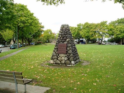
©Parks Canada Agency / Agence Parcs Canada, 2008 |
Marpole Midden National Historic Site of Canada
Vancouver, British Columbia
Marpole Midden National Historic Site of Canada is situated near the
northern end of the Arthur Laing Bridge, at the southern edge of the
city of Vancouver, British Columbia. This massive midden site contains
remains of a Coast Salish winter village dating from the Marpole phase
culture, as well as shellfish remains and various artifacts from early
inhabitants of the site found in an average depth of 1.5 metres and a
maximum depth of 4.6 metres, dating from 1500 to 2900 years ago. Other
undisturbed deposits lie beneath much of the urban fabric covering the
site.
The scientific value of Marpole midden lies on its invaluable
informative contribution concerning the early occupation of the Fraser
Delta and, especially, the Marpole phase culture. A vast, pre-contact
debris area, the midden is mainly composed of rich shellfish deposits,
which stand as evidence of its original placement beside the Georgia
Strait at the mouth of the Fraser River. Westward growth of the Fraser
Delta, through natural deposition, has relocated the site.
The midden also contains numerous cultural remains from its early native
inhabitants, in particular those associated with the Marpole phase
culture corresponding with the about 400 BCE to 450 CE period. Bone and
stone implements, utensils and ornaments have been recovered through
various archeological excavations. They testify to the maritime
orientation and the highly developed woodworking skills, which
characterized the the Coast Salish people, and also other later
Northwest Coast cultures, such as the Musqueam. The excavation of this
extensive midden led by Charles Hill Tout, in 1892, has stimulated
archaeological study of other such prehistoric refuse heaps on the
Pacific slope. By 1955, urban expansion had significantly altered the
landscape of Marpole Midden, covering the site in homes, infrastructure
and other typical urban features.
|
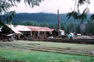
©Parks Canada Agency / Agence Parcs Canada, 1996 |
McLean Mill National Historic Site of Canada
Port Alberni, British Columbia
McLean Mill National Historic Site of Canada is a former sawmill and
logging operation located on 13 hectares of forested land in the Alberni
Valley of Vancouver Island. The formal recognition consists of some 35
structures and the land surrounding them. Built resources include an
operational steam operated sawmill, and ancillary structures including a
wide variety of wooden garages, storage structures and outbuildings, a
cluster of wooden residences and administrative buildings, and a rail
line. Landscape features include outdoor areas for processing and
storage of lumber, and a mill pond.
McLean Mill is a rare, surviving example of an early- to
mid-20th-century logging and lumber operation in British Columbia.
Established in 1925 by Robert Bartlett McLean, his wife Cora and their
three sons, it continued as a family-run operation until 1965. Built
resources at the site were constructed of local materials by the McLean
family and their workers. The deliberate creation of zones of activity
is still plainly visible. The site includes a steam-powered sawmill and
original machinery representative of the range of activities undertaken
in the forest industry. Built resources and machinery span the 40 years
of mill operation, demonstrating the typical components of a British
Columbia sawmill and logging operation and their evolution over that
period. The site also includes transportation facilities for a
steam-powered locomotive.
|

©Parks Canada Agency / Agence Parcs Canada, L. Dick, 1997 |
Metlakatla Pass National Historic Site of Canada
Metlakatla, British Columbia
Metlakatla Pass National Historic Site of Canada is located on Pike
Island near the western end of the Metlakatla Pass, a narrow, protected
ocean channel at the northern entrance to Prince Rupert Harbour on
British Columbia's northern coast. Metlakatla Pass was traditionally the
place where the Northern Coast Tsimshian established their wintering
villages. Coniferous forest covers the island while its shoreline
contains archaeological sites and remains that include five First
Nations sites, three former villages and two petroglyph sites. The
largest village site, occupied prior to and following contact with
Europeans, covers an area measuring 211 by 70 metres. The two older
village sites measure 115 by 95 metres and 75 by 45 metres respectively.
Trails link the islands village sites, while the petroglyphs are carved
on boulders or rock outcrops on the island's beaches.
Metlakatla Pass was traditionally the place where the Northern Coast
Tsimshian and ancestral groups established their wintering villages. The
site illustrates not only several chapters of Tsimshian history at the
pass, but also represents significant components of this long-term
history of the Northern Coast Tsimshian at Metlakatla. The island's
natural setting imparts an historical ambience and spirit of place,
which helps to communicate its historic value to visitors. By the late
1830s the Tsimshian had moved from Metlakatla to new wintering quarters
at Fort Simpson (Hudson Bay Company). In 1862 William Duncan, a young
Anglican Missionary, initiated a move back to Metlakatla to establish a
model community. In 1887 Duncan and part of the Tsimshian community
departed for Alaska. Pike Island remains the property of the Metlakatla
First Nation.
|
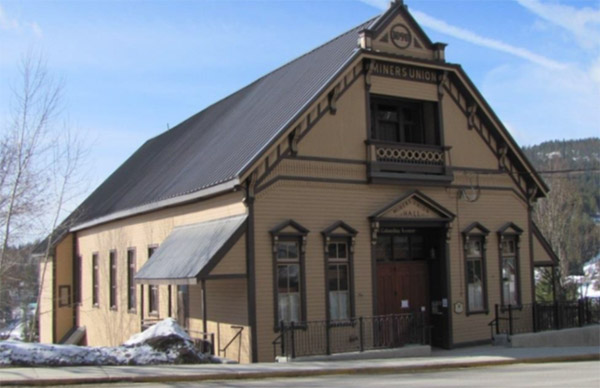
©Parks Canada / Agence Parcs Canada, Christine Boucher, 2018 |
Miner's Union Hall National Historic Site of Canada
Rossland, British Columbia
Located at 1765 Columbia Avenue in Rossland, British Columbia, the Miners' Union
Hall was built in 1898 to serve as a meeting place for Local 38 of the Western
Federation of Miners. This building testifies to the union's determined battle
for miners' rights in the region, which led to legislation guaranteeing an
eight-hour work day for miners in the province (1899) and contributed to the
enactment of the Conciliation Act (1900). A rare surviving building of its type
in Western Canada, this eclectic, wooden, late-Victorian Gothic Revival Style
building serves as a major landmark for the community. Retaining excellent
architectural integrity, it remains an important community meeting place for the
people of Rossland. Furthermore, it is a particularly rare and eloquent example
in Canada of a building expressly designed to house a union hall.
The Western Federation of Miners (WFM) was a union for metallurgy industry
workers in western North America, and Local 38 of WFM, founded in 1895, was the
first local in the mining sector in BC. It became one of the most influential
and productive in the history of the province. Among other things, the union
fought for fair and safe working conditions for miners, and helped pave the way
for the union movement in BC. The Miners' Union Hall served as a space for union
meetings, and also welcomed various other social and community events. In the
1960s, a new union hall was acquired in the nearby community of Trail, and the
Rossland Miners' Union Hall fell into disrepair. In the 1970s, the Rossland
Heritage Society was formed, and rehabilitation work began on the hall. The
building was sold to the City of Rossland and reopened its doors in 1983. The
rehabilitation work carried out over the years, mainly in the late-1970s, and
more recently in 2016-17, has helped to preserve the main characteristic
elements of the building, including its volumetrics, the ordering of its
facades, the distribution of the interior spaces, its materials, and its main
decorative elements. A multi-purpose building, it is used by the community as a
meeting and reception hall, and as a theatre for plays and artistic
performances. The recent restoration work also allowed the 4th-storey attic to
be renovated to become a space that can be used to meet the needs of the public.
Architecturally, the Miners' Union Hall is an impressive example of a
late-Victorian Gothic Revival Style building. Designed by E.J. Weston, an
American architect practicing in Los Angeles, the rectangular wooden building
has a steeply-pitched gable roof and a central balcony on the upper floor. Its
façade is characterized by symmetry and by a number of classical architecture
elements, including the windows and doors with triangular pediments, the inset
central balcony and its carved wooden ornamentation. The side facades are also
characterized by a symmetry that is highlighted by high rectangular windows
providing considerable natural light. Original inscriptions, including "1898" at
the central gable, "Miners Union" at the balcony, and "Miners Union Hall" over
the central door, speak to this building's history.
|

©Parks Canada Agency / Agence Parcs Canada, Arnold E. Roos, 1999 |
Motor Vessel BCP 45 National Historic Site of Canada
Campbell River, British Columbia
Motor Vessel BCP 45 National Historic Site of Canada, permanently housed
at the Campbell River Maritime Heritage Centre, is a 14.3 metre
single-screw fishing vessel of wood construction. The vessel has a low
raised foredeck and a deckhouse located forward of midship. This
configuration was typical of a wooden fish seiner from the west coast of
Canada.
Motor Vessel BCP 45 was one of several fishing vessels built to a
standard design for its original owner, BC Packers Ltd., the dominant
canning company on the British Columbia coast during the second half of
the 20th century. It was built in 1927 by Burrard Shipyard in Coal
Harbour, Vancouver, considered the heart of wooden shipbuilding along
the coast during the period. In addition to its direct association with
important changes in the social structure of the west coast fishing
industry, Motor Vessel BCP 45's lengthy operational life reflected many
of the technological changes that had significant impacts on the fishing
community. It was operated successively as a table seiner, troller,
Puretic block seiner, packer, and finally, as a drum seiner. Through its
design, adaptation to successive technologies, and direct associations
with the dynamics of the fishing industry and the important role of
Aboriginal Peoples in it, Motor Vessel BCP 45 has become a fitting
symbol and a familiar national icon of the fishing industry in
Canada.
|
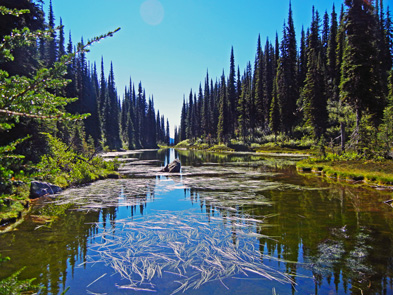
©Parks Canada Agency / Agence Parcs Canada |
Mount Revelstoke National Park of Canada
Headquarters: Revelstoke, British Columbia
Rainforest of 1,000-year-old cedars and spectacular mountains.
Mount Revelstoke National Park is a place of contrasts. Take a drive
along the Meadows in the Sky parkway through a variety of geographical
zones. From dense old-growth rainforest of giant cedar and pine, travel
up through subalpine forest, and finally alpine meadows and tundra.
Marvel at the spectacular view of the ice-clad peaks of the Monashee
Mountains and, to the east, the Selkirk Mountains. The Giant Cedars
hiking trail takes you through a stand of ancient Western Red Cedars,
and the Skunk Cabbage Boardwalk trail introduces you to jungle-like
wetland, a birder's paradise.
|
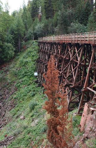
©Parks Canada Agency / Agence Parcs Canada, HRS 1131, 2004 |
Myra Canyon Section of the Kettle Valley Railway National Historic Site of Canada
Central Okanagan, British Columbia
The Myra Canyon Section of the Kettle Valley Railway National Historic
Site of Canada is a 9.6 km section of railway roadbed which traverses
extremely mountainous terrain by means of a series of high, steel and
wooden trestles and tunnels.
The Myra Canyon Section of the Kettle Valley Railway was designated a
national historic site of Canada because the location, layout and
construction of the Kettle Valley Railway through the Myra Canyon
constitutes an outstanding engineering achievement which employed
conventional technologies in highly imaginative and ingenious
application in routing and constructing a railway in mountainous
terrain.
The heritage value of this site resides in its illustration of a
remarkable engineering feat. This section of track was in rail use from
its completion in 1914 until it was closed to train traffic in 1978. It
was subsequently developed for pedestrian use as part of the Trans
Canada trail. In 2003 it was seriously damaged by fire.
|

©Parks Canada Agency / Agence Parcs Canada |
Nan Sdins National Historic Site of Canada
Gwaii Haanas National Park Reserve of Canada, British Columbia
Remains of Haïda longhouses and totem poles.
|
|
New Gold Harbour Area National Historic Site of Canada
Haina, British Columbia
|

©Parks Canada Agency / Agence Parcs Canada, C. Cournoyer, 2006 |
Nikkei Internment Memorial Centre National Historic Site of Canada
New Denver, British Columbia
Nikkei Internment Memorial Centre National Historic Site of Canada is
located in New Denver, British Columbia, on the shores of the northeast
end of Slocan Lake in the western part of the Kootenay region. It sits
on a large piece of land that was used to grow vegetables until the
internment camp was built during the Second World War. The site is
surrounded by a tall, wooden fence with two gates at the front to
indicate to visitors that they are about to enter a special place. A
traditional Japanese ornamental garden and a meandering path contrast
with the austere cabins in which the internees lived. The site also
includes a Buddhist sanctuary, a number of artefacts and interpretative
panels, and a collection of handwritten documents and illustrations.
The Nikkei Internment Memorial Centre is closely associated with the
internment of Japanese during the Second World War. It is in the middle
of what is known as "The Orchard", the site of an internment camp built
from scratch by the Canadian government to house forced evacuees from
the West coast. The camp is one of the few detention sites built for
internment that was not torn down after the war and the only one where
descendants of the Japanese Canadians who were displaced have lived
since.
The Nikkei Internment Memorial Centre was created in 1992—1994 in order
to preserve buildings associated with the internment and in doing so,
commemorate the internees' experience.
|
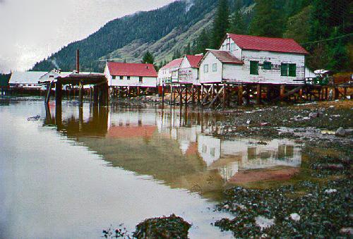
©Parks Canada Agency / Agence Parcs Canada, 2002 |
North Pacific Cannery National Historic Site of Canada
Port Edward, British Columbia
The North Pacific Cannery National Historic Site of Canada is a 19th-
and 20th-century salmon cannery complex, located in the community of
Port Edward, just south of the city of Prince Rupert on the northwest
coast of British Columbia. The cannery complex is situated on a narrow
strip of land between the mountains and the Inverness Passage, at the
mouth of the Skeena River and is comprised of a cluster of wooden
buildings, mostly one-storey in height, grouped along a wooden
boardwalk. The boardwalk and many of the buildings are supported on
piles over the water. The site is now operated as a cannery museum.
The North Pacific Canning Company Ltd. was first established in 1889 by
John Carthew. He later sold the cannery to Henry Bell-Irving in 1891,
who operated it as the Anglo-British Columbia Packing Company. It
remained in active operation until 1980. The built resources at the site
represent a relatively intact assemblage of structures associated with
various aspects of the West Coast fishing industry over almost 100
years. Although somewhat modified, the main cannery building (1889) is
the oldest surviving cannery building in British Columbia. The complex
was the site of numerous activities, including a salmon cannery
(1890s-1950s), a cure plant (1890s-1920), a can-making factory
(post-World War I), a cold storage plant (1900-54), a free oil
production plant (early 1950s), and a herring reduction plant (1955-68;
and 1972-80). The layout and built resources of the complex, including a
power plant, provisions storage, and workers' housing, reflect its
initial isolation and consequent self-sufficiency, both typical of
northern coastal canneries. The design and layout of workers' housing
reflects the multicultural workforce and the ethnic segregation in
living and work areas.
Its rich collection of buildings and structures demonstrate the
evolution, industrial processes and complex organization of a northwest
coast cannery. Collectively, the buildings illustrate the infrastructure
necessary to process a range of products associated with the west coast
fishing industry. The buildings document the self-sufficiency of the
Cannery through much of its history, the cultural variation and
segregation of its workforce, and the work and domestic lives of the
cannery workers and their families. Collectively, the buildings of the
Cannery complex represent the demographic realities of single-resource
communities, and the role played by European, Asian and First Nations
cultures in the development of the West Coast Fishing Industry and the
industrial development of British Columbia.
|
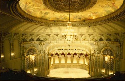
©Parks Canada Agency / Agence Parcs Canada |
Orpheum Theatre National Historic Site of Canada
Vancouver, British Columbia
The three-storey Orpheum Theatre is located in the busy entertainment
district of Vancouver, adjacent to other historic Edwardian commercial
buildings on Granville Street. Expanded in the 1980s, a new entrance to
the theatre was created on one side of the building, with the Granville
Street elevation retaining its original symmetrical brick and terra
cotta façade with a large canopy and vertical neon sign.
Orpheum Theatre was designated a national historic site of Canada in
1979, because it is a good example of a Canadian movie palace, and one
of the few to survive in relatively unchanged condition.
Considered the 'Grand Old Lady of Granville', Vancouver's fourth Orpheum
Theatre was one of seventeen grand movie places in Canada built by the
Chicago-based Orpheum Circuit and the largest and most extravagant
theatre on the Pacific Coast. It exemplified the faith of the company in
the metropolitan growth of Vancouver and it became a symbol of
Vancouver's progress.
The Orpheum Theatre was designed by B. Marcus Priteca, a Seattle-based
architect who designed nearly two hundred theatres from San Diego to
Alaska. Priteca introduced many innovations to theatre design including
the triple-domed ceiling, a deep, cantilevered balcony with carefully
angled seating for improved sight lines, an orchestra pit, and a
mezzanine. Priteca was also a master at economically creating the
illusion of opulence with plasterwork on reinforced concrete. Frederick
J. Peters was the associated architect on the project.
The Orpheum is an excellent example of theatre design of the 1920s.
Centrally located in an urban area, it offered a large seating capacity,
spacious foyer and lobby areas, and a lavish interior décor that created
an atmosphere of exotic luxury. Throughout the richly decorated common
areas of the theatre are a series of repeating motifs such as colonnades
that provide constant visual stimulation and multiple, controlled
perspectives. The design is a mélange of architectural influences - the
vaulted ceilings of the main concourse and foyer and the terra cotta
undersides of the marquees and the travertine walls and pillars are
Italian influenced, there are exotic ceiling motifs, crests of British
heraldry, chandeliers of Czechoslovakian crystal, Moorish-inspired organ
screens, and Baroque ceiling and dome covers.
The Orpheum Theatre was an important landmark in the development of
Granville Street as entertainment area from the 1920s to the 1940s. Long
under the management of master showman Ivan Ackery, a number of
prestigious acts have graced its stage, many related to Orpheum Circuit
productions. Audiences have been entertained by symphonies, vaudeville
acts and movies by some of the world's most famous performers. The
Orpheum hosted Vancouver's first radio theatre and it is home to B.C.'s
'Starwall Gallery' inside the theatre and 'Starwalk' along theatre row
to honour British Columbians who have excelled in all disciplines of the
entertainment arts.
The theatre was one of the first large-scale heritage conservation
projects undertaken in Vancouver. Between 1974 and 1977, renovations
were carried out by the firm Thompson, Berwick, Pratt and Partners of
Vancouver. Today the theatre thrives as the city's premier concert hall
and as home to the Vancouver Symphony Orchestra.
|
©Parks Canada Agency / Agence Parcs Canada, 2014 |
Pacific Rim National Park Reserve of Canada
Headquarters: Ucluelet, British Columbia
Pacific Coast Mountains make up this marine and forest
environment.
Backed by the Vancouver Island Range and facing the open Pacific Ocean,
Pacific Rim presents the rich natural and cultural heritage of Canada's
west coast. Its cool and wet maritime climate produces an abundance of
life in the water and on land. Lush coastal temperate rainforest gives
way to bountiful and diverse intertidal and subtidal areas. These
natural wonders are interwoven with the long and dynamic history of the
Nuu-chah-nulth First Nations and European explorers and settlers.
|
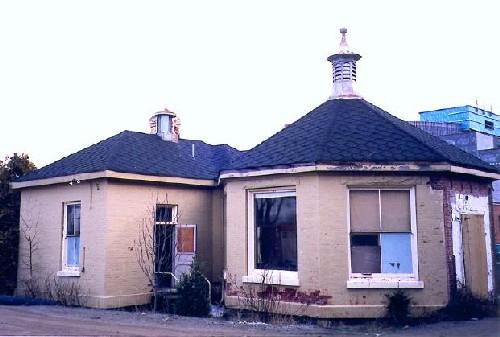
©Parks Canada Agency / Agence Parcs Canada, 2001 |
Pemberton Memorial Operating Room National Historic Site of Canada
Victoria, British Columbia
The Pemberton Memorial Operating Room is located in the heart of the
Royal Jubilee Hospital complex in Victoria. The site consists of an
octagonal brick operating room built in 1896 and two sterilizing rooms,
one original, the other added in 1918. The two sterilizing rooms
comprise a single rectangular brick structure that is attached to a
single wall facet of the octagonal operating room. Large windows, with
sandstone lintels and concrete sills, dominate six facets of the
exterior. A ventilation cupola graces the peak of the octagonal
operating room roof, with a smaller ventilator located on the ridge of
the hipped roof covering the sterilizing room section.
The operating room was designed by noted Victoria architect John Teague
in consultation with Dr. John Chapman Davie, the driving force behind
the introduction of Lister's theories of antiseptic surgery to Victoria.
Incorporating elements of both 19th- and 20th-century design, this
building illustrates the transition that was taking place in hospital
design at this time. The structure was designed to provide a space that
could be kept clean and provide a sterile environment, suitable for
operation. The large windows that punctuated the walls of the operating
theatre provided ample natural light while the ceramic tiled floors,
plastered and painted walls could be easily cleaned, disinfected and
well-ventilated with the aid of the modern plumbing, heating and
ventilation systems. Although originally linked to the main hospital by
a wooden corridor, the operating room is defined as a discrete form so
as to minimize the risk of contamination from the outside. The site is
currently surrounded by recently landscaped garden features and a
parking lot that provide buffers between it and the larger modern
hospital complex and a contemporary chapel.
|
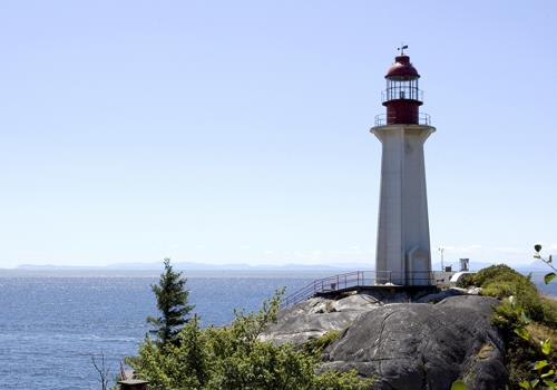
©Point Atkinson Lighthouse, Mandy Jansen, 2009 |
Point Atkinson Lighthouse National Historic Site of Canada
West Vancouver, British Columbia
Point Atkinson Lighthouse National Historic Site of Canada is located in
the 75-hectare Lighthouse Park, across Burrard Inlet from Vancouver,
British Columbia. It stands on a promontory adjacent to the largest
first growth stand of coastal elevation trees in the Lower Mainland.
Measuring 18.3 metres in height, the hexagonal light tower is
constructed of reinforced concrete. The keeper's cottage and a small
complex of army huts built during the Second World War stand next to the
tower.
The first of three lighthouses to serve the Port of Vancouver, the Point
Atkinson Lighthouse was built to protect Vancouver's growing
international shipping trade. Constructed in 1912 by contractor W.H.
Rourke, it replaced an earlier wooden structure that was built in 1875.
Its reinforced concrete construction was an innovation in lighthouse
design that appeared in Canada in the first decade of the 20th century.
Now automated, the lighthouse continues to provide navigational aid to
all marine traffic approaching Vancouver from the northwest.
|

©Parks Canada Agency / Agence Parcs Canada, 1991 |
Point Ellice House / O'Reilly House National Historic Site of Canada
Victoria, British Columbia
Point Ellice House / O'Reilly House National Historic Site of Canada, is
located on a treed parcel of land overlooking the Gorge Waterway in
Victoria, British Columbia. It is an attractive, asymmetrical,
one-storey Victorian cottage set in an informal picturesque garden with
winding paths, mature trees and selective planting. Of timber
construction, the house is distinguished by its picturesque gingerbread
details, such as its bracketed eaves, and its bowed roof verandah with
balustrades and finely necked columns.
Built in 1861, the house was then enlarged between 1875 and 1889 during
the ownership of Peter O'Reilly, Chief Gold Commissioner for British
Columbia and a prominent resident of Victoria. The house was acquired by
O'Reilly in 1867 and was continuously occupied by successive generations
of his family until 1975. The aesthetic tastes of prosperous gentry in
the Victorian period are perfectly expressed through the eclectic
development of this picturesque cottage, its lavish garden setting, and
its interior spaces, which have remained virtually unchanged and are
filled with the accumulated possessions of the O'Reilly family. Once
surrounded by stately homes in one of Victoria's most fashionable
residential neighbourhoods, Point Ellice House / O'Reilly House now
represents a rare example of a 19th-century design tradition that has
largely vanished in the wake of urban redevelopment. The site currently
operates as a museum.
|

©PRA, neg. 14110, May 1956 |
Powell River Townsite Historic District National Historic Site of Canada
Powell River, British Columbia
Powell River Townsite Historic District National Historic Site of Canada
is a planned, single-industry town from the first half of the 20th
century. Located at Powell River, British Columbia, the residential
neighbourhood of standard-plan, wood-frame houses climbs a short
distance up the hill behind the enormous pulp and paper mill and then
stretches to the south in a gentle crescent along a heavily forested
area. The extent of the site is defined by the Malaspina Strait, the
Powell River and heavily wooded mountains.
The heritage value of the site resides in its physical manifestation of
an early 20th-century planned, single-resource community. Developed by
the Powell River Company in 1911, the early plan was implemented by
George F. Hardy, a New York engineer, and later enlarged by architect
John McIntyre.
|
©Parks Canada Agency / Agence Parcs Canada, Andrew Waldron, 2011 |
Rogers Building National Historic Site of Canada
Victoria, British Columbia
The Rogers Building is a small Victorian era commercial building with a
fanciful Queen Anne Revival-style shopfront. It is located in the
downtown area of the city of Victoria.
The Rogers Building was designated a national historic site in 1991
because this shop is a delectable adaptation of the Queen Anne Revival
style applied to small commercial buildings.
The facade of the Rogers Building typifies commercial applications of
the Queen Anne Revival Style. Original fixtures and decorative features
in the store's interior create a warm, inviting atmosphere typical of
the style.
|
©Albertype Company / Library and Archives Canada - Bibliothèque et Archives Canada / PA - 032019, ca/v. 1900-1925 |
Rogers Pass National Historic Site of Canada
Glacier National Park of Canada, British Columbia
Canadian Pacific Railway route through Selkirk Mountains.
Rogers Pass National Historic Site of Canada is a historic travel
corridor through the Selkirk Mountains between an upper reach of the
Columbia River as it flows north to cross the Selkirks at the Big Bend
and a lower reach where the river flows south. Located today within the
boundaries of Glacier National Park of Canada.
The heritage value of Rogers Pass lies in its historic associations
(1886-1917) as illustrated by the associated landscape and resources
along the route of the Trans-Canada Highway through the Selkirk
Mountains.
Following the decision of the Canadian Pacific Railway in 1881 to adopt
the southerly route through the Rockies at Kicking Horse Pass, it became
necessary to find a way through the difficult and largely unexplored
Selkirks. Major A.B. Rogers, an experienced American railway locating
engineer, traversed this pass the next year and so overcame the last
great obstacle facing the railway. The steep grade and susceptibility to
avalanches made the pass a treacherous part of the line, so the
Connaught Tunnel was built in 1916 to bypass it. With the inauguration
of the Trans-Canada Highway in 1962, however, it again formed part of a
national route.
|
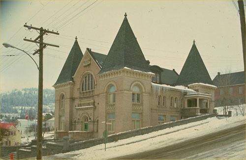
©Parks Canada Agency / Agence Parcs Canada |
Rossland Court House National Historic Site of Canada
Rossland, British Columbia
The Rossland Court House National Historic Site of Canada is a
substantial two-storey brick building located on a steeply sloping site
that affords a commanding view over the surrounding area and showcases
its landmark status within the community. Constructed of buff brick over
a stone basement, the building's distinctive design incorporates
projecting tower sections on all four corners, three of which are
crowned by steep tile-clad pyramidal roofs. The building's exterior wall
surfaces are richly ornamented with polychromatic detailing. Its
interior is beautifully preserved and distinguished by the wood panelled
court room and massive stained glass window bearing the provincial coat
of arms flanked by the coats of arms of colonial Chief Justice Matthew
Baillie Begbie and colonial Governor James Douglas.
The Rossland Court House was designated a national historic site in 1980
because it is highly representative of a distinctive regional form of
Canadian court house that emerged in British Columbia during the late
19th century.
The province's early law makers strove to emphasize the English origins
of the province's legal system in newly-settled regions in the wake of
large waves of American miners and fortune seekers. In important mining
centres such as Rossland, this intent was reflected in the design of a
court house which served as a visual symbol of the Crown's authority.
Wood-beamed ceilings, wood panelled walls and stained glass windows cast
a solemn atmosphere over court proceedings, while court house exteriors
were intended to convey a distinctly British character. Designed by
Glasgow native J.J. Honeyman, Rossland's court house epitomizes this
approach to court house design through its well-preserved exterior and
interior.
|

©Parks Canada Agency / Agence Parcs Canada, Andrew Waldron, 2011 |
Royal Theatre National Historic Site of Canada
Victoria, British Columbia
The Royal Theatre is a large, brick-faced theatre building occupying
most of its urban lot in downtown Victoria.
Royal Theatre National Historic Site was commemorated as a building of
both historic and architectural significance because it is one of the
finest surviving large-scale legitimate theatres in Canada.
The heritage value of the Royal Theatre is illustrated by the building
itself, its monumentality and grandeur of surviving fabric. Built as The
Royal Victoria Theatre in 1912-13 by the Victoria Opera House Company
(William D'Olyly Rochfort and Eben W. Sankey, architects), this theatre
was a venue for live dramatic, musical and vaudeville performances.
Famous Players acquired the building in 1930, changed its name to the
Royal Theatre, and established its primary use as a movie theatre. The
Royal Theatre was restored as a live theatre in 1972.
|
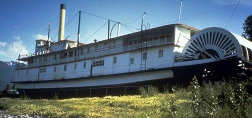
©Parks Canada Agency / Agence Parcs Canada |
S.S. Moyie National Historic Site of Canada
Kaslo, British Columbia
The S.S. Moyie National Historic Site of Canada is a late 19th-century,
steam-propelled, stern-wheeler, located on the south shore of Kaslo Bay
on Kootenay Lake. She has been in dry dock since 1958.
The S. S. Moyie was built and assembled in 1898 at the Canadian Pacific
Railway shipyard at Nelson, British Columbia. She is typical in most
respects of steam-powered vessels on western and northern inland waters
but is distinguished from other steamers by the composite construction
of her hull, comprised of steel frame with wooden planking. Her steel
frame and propulsion machinery were supplied by Bertram Engine Works of
Toronto.
The S. S. Moyie was built to provide marine service across Kootenay Lake
from Nelson to Kootenay Landing, thereby connecting the Crowsnest Pass
Railway with the Canadian Pacific lines to the west. Her interior
arrangements suit this use, with plenty of dining room and lounge space,
and sleeping cabins. Operated by the Canadian Pacific Railway's British
Columbia Lake and River Service, the S.S. Moyie provided various
services on Kootenay Lake from her launch in 1898 until her retirement
in 1957.
|

©Parks Canada Agency / Agence Parcs Canada |
Saint Paul's Roman Catholic Church National Historic Site of Canada
North Vancouver, British Columbia
Saint Paul's Roman Catholic Church National Historic Site of Canada,
with its twin spires and Gothic Revival style, is a local landmark
located on the fifteen hectare Mission First Nations Reserve on the
North Shore of Burrard Inlet, across from the Vancouver Harbour. It is
situated within the Mission Reserve, surrounded by housing and public
buildings and adjacent to a 'Celebration of Creation Garden,' created
for the Squamish Nation Elders in 1998.
Saint Paul's is associated with the Oblates of Mary Immaculate, a Roman
Catholic missionary order that played an important role in the
introduction of Catholicism to western Canada and the lower mainland of
British Columbia. Established in 1864, this mission reserve was the
first permanent settlement in the area now known as North Vancouver. The
original chapel dating from the mid-1860s was replaced in 1884 by a
larger frame church with a projecting front steeple. The current St.
Paul's church, which incorporates the walls of the 1884 church, was
extensively remodeled and expanded with the addition of twin spires in
1909.
Saint Paul's is a fine example of Gothic Revival ecclesiastical
architecture in Canada. The walls of the 1884 building were retained but
lofty 26-metre-high corner towers replaced the original central tower.
The addition of transcepts and a vestry, along with circular-shaped
chapels, created a sophisticated cruciform shape that was without
precedent among Oblate mission churches in British Columbia. Apart from
two chancel columns retained from the 1884 structure, decoration was
confined to fret-sawn trim, largely removed in later renovations. The
church was reopened in 1910 and named St. Paul's in memory of Father
Durieu, the first Oblate missionary in the area. St. Paul's was the last
mission church of this scale and complexity to be built on a First
Nation mission in British Columbia, and is the last surviving
example.
|
©M.A. Klassen |
Similkameen Spirit Trail National Historic Site of Canada
Hedley, British Columbia
Similkameen Spirit Trail National Historic Site of Canada is located
within the traditional territory of the Upper Similkameen Indian Band,
in southern British Colombia. The site spreads across lakeside cliffs,
rolling valleys surrounded by steep serrated peaks and small bedrock
outcrops on the floodplain. The site is composed of three major
components linked by an aboriginal trail route: the Tulameen Ochre
Bluffs, Chuchuwayha Rock Shelter, and a series of 27 pictograph sites.
Combined, these components are representative of a cultural landscape
illustrating the major aspects of Upper Similkameen culture and history
spanning over 4000 years.
The Upper Similkameen cultural landscape symbolizes the connection
between the Upper Similkameen people, the landscape, and the spirit
world. Following the trail route physically and metaphorically
represents the journey between the material and spiritual realms. The
bluffs at the western end of the commemoration area provide the ochre
used to communicate with the spirits. At the eastern end of the
commemoration area, pictographs, oral traditions, and layers of
archaeological history at the Chuchuwayha Rock Shelter represent the
connection of the spirit world with an ancient habitation site of the
Upper Similkameen people. Along the old trail route, between Tulameen
and Chuchuwayha, lie dozens of pictograph sites, marking the place where
young men and women fasted and prayed to the spirits, and where
representations of dreams and guardian spirits were painted upon the
rocks. Red, orange and yellow ochre taken from the Tulameen Ochre Bluffs
was used as a paint to create substantial pictographs, which date from
around 4000 years ago. The ochre was also used for spiritual and
ceremonial purposes, for decorating clothes and other items, and making
face and body paints. The Bluffs are located near the confluence of the
Similkameen and Tulameen Rivers that were major Aboriginal travel and
trade routes connecting the coast and the interior. The cliffs were also
a major regional source of chert, which was used to make stone tools.
The Upper Similkameen valley contains one of the highest concentrations
of pictographs on the interior plateau of British Colombia. The
pictograph sites range in size from single glyphs to complex
compositions, and exhibit a wide variety of motifs and designs. They are
mainly painted on large boulders that have fallen from the steep valley
walls. Although some of the pictographs are similar to those found
throughout the southern interior of British Colombia, many of the ones
from the site display distinct Similkameen motifs. The Chuchuwayha Rock
Shelter, which exhibits some of these pictographs, lies underneath one
of the cliffs on the north side of the valley, in an open park-like
setting of Douglas fir. The Shelter is a shallow rock overhang at the
base of a high, smooth granite face. Excavations inside the rock shelter
have revealed deeply stratified cultural deposits, with archaeological
evidence spanning 200 to 4000 years BCE, attesting to the long-term
human use of the shelter.
|
©Parks Canada Agency / Agence Parcs Canada |
Skedans National Historic Site of Canada
Gwaii Haanas, British Columbia
Former Haïda village.
|
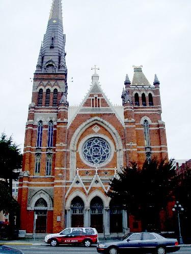
©Parks Canada Agency / Agence Parcs Canada, Mario Savard, 2008 |
St. Andrew's Roman Catholic Cathedral National Historic Site of Canada
Victoria, British Columbia
St. Andrew's Roman Catholic Cathedral National Historic Site of Canada
is an imposing heritage landmark in the urban core of Victoria, B.C. The
cathedral's twin-towered design has a strong vertical emphasis and a
picturesque asymmetry that is enhanced by a soaring spire and a bold
combination of red brick, pale grey stone, slate and metal building
materials. Ornate vaulting, stained glass and galleries contribute to
the sense of grandeur within the well-preserved interior.
Designed in 1892 by Perrault and Mesnard of Montreal, and built by
contractor J.H. Donovan, St. Andrew's was inspired by the medieval
cathedrals of Europe, whose emphatic verticality and picturesque
asymmetry greatly appealed to 19th-century architectural taste. The
influence of French Gothic Revival style is evident in the twin towered
façade, centre rose window and the triple entrance portal. Features such
as the rich array of contrasting colours and materials created by the
red-brick walls with grey stone trim and slate roof were characteristic
of the High Victorian Gothic Revival Style.
|
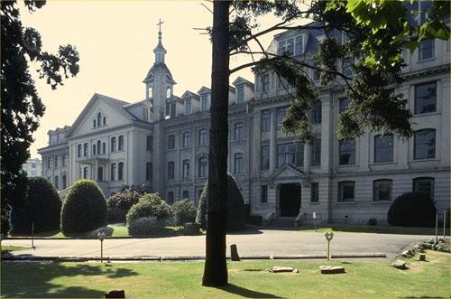
©Parks Canada Agency / Agence Parcs Canada, 1992 |
St. Ann's Academy National Historic Site of Canada
Victoria, British Columbia
The St. Ann's Academy National Historic Site of Canada is comprised of a
monumental brick-clad building and former gardens which occupy
approximately 6.25 acres of land within Victoria's original urban core.
The garden contains a formal processional allée created with tree rows
and hedges, an orchard containing approximately 100 original fruit
trees, a novitiate garden, a formally landscaped area containing several
historic trees, structural remnants, formal gardens, hedges, historic
paths and walkways, and additional plantings established by the Sisters
of St. Ann around the Academy building and along sections of the site
perimeter, and a perimeter wall and gates.
St. Ann's Academy was designated a national historic site of Canada
because of its role in the cultural and educational life of Western
Canada for over a century, and because of its landmark status - due to
its scale and the surrounding open space (formerly the gardens) - in the
community.
Arriving in Victoria in 1858, the Quebec-based Sisters of St. Ann
responded to the educational and nursing needs on the West Coast by
opening a succession of convents, hospitals and mission schools
throughout British Columbia, Yukon and Alaska. Their success created a
demand for larger accommodations in Victoria which was met by
construction of the first section of the present building in 1871, then
by further additions in 1886 and 1910. From 1871 until its closing in
1973, St. Ann's retained its stature as an important educational
institute, and continues to symbolize the Sisters' contribution to
education and social service in Western Canada.
The distinctive architecture of St. Ann's Academy reflects the strong
influence of French Canadian religious orders during a formative period
in the history of British Columbia. It was the largest building in the
province in 1871, and remained the tallest masonry building in Victoria
for most of its history. While the 1871-86 and 1910 sections of the
building embody the neo-baroque characteristics of 19th-century Quebec
convent design, the chapel is a unique transplantation of traditional
17th- and 18th-century Quebec ecclesiastic design tradition to the west
coast. Built as the original Roman Catholic cathedral in Victoria in
1858 by Brother Charles Michaud, the original timber framed building was
moved to its current site and incorporated into the academy complex in
1886. The heritage value of the chapel resides in its well-preserved
interior massing and design features.
The landmark qualities and monumental scale of the Academy were enhanced
by its positioning on the property, and by the landscaping of a formal
driveway, rows of tree, hedges, formal gardens, orchard and perimeter
walls. These elements impart an enclosed quality to the site, producing
a tranquil setting that symbolized the religious and institutional
character of the academy and communicated its separateness from the city
beyond. The coherent treatment of building and landscape reflects over
100 years of continuous ownership and stewardship by the Sisters of St.
Ann.
|

©Parks Canada Agency / Agence Parcs Canada, 1982 |
St. Roch National Historic Site of Canada
Vancouver, British Columbia
Dry-docked in a purpose-built A-frame structure as part of the Vancouver
Maritime Museum at Kitsilano Point, the St. Roch is an auxiliary Royal
Canadian Mounted Police schooner restored to her external appearance as
she was during her 1944 crossing of the Northwest Passage. She is 31.6
metres long with a beam of 7.6 metres, a depth of hold of 3.4 metres and
a displacement of 323 tons. St. Roch is made primarily of thick Douglas
fir planks with hard Australian Eucalyptus 'iron bark' on the outside
and an interior hull reinforced with heavy beams to withstand ice
pressure.
The Canadian-built St. Roch is valued as an excellent example of
Canada's maritime history. She navigated the Northwest Passage, arriving
in Halifax in 1942, after spending two winters frozen in the ice. She
was the second ship to make the Passage, and the first to conquer the
journey from the Pacific to the Atlantic. In 1944, the refitted St. Roch
returned to Vancouver via the more northerly, deep route of the Prince
of Wales Strait in eighty-six ice-free days — the first to navigate the
Northwest Passage in a single season. Retired in 1948, St. Roch was sent
to Halifax via the Panama Canal in 1950, making her the first ship to
circumnavigate North America.
Under the command and leadership of Sergeant Henry Larsen (1899-1964)
who was first mate and captain for twenty years, the voyages of the St.
Roch demonstrated Canadian sovereignty in the Arctic. She extended and
maintained Canadian control over its vast northern territories as an
all-purpose supply, patrol and transport vessel and governmental
representative to service isolated and relatively inaccessible R.C.M.P.
detachments by settling disputes and conducting a census of the Inuit.
During this time the St. Roch was the only federal presence in the far
north. During the Second World War the St. Roch was sent through the
North West Passage to protect war industries in the north, specifically
a mine in Greenland which was the sole source of cyrolite essential to
the production of aluminum.
The heritage value lies in the original design and the multiple refits
that were designed to deal harsh conditions and reflect the changing
technologies in marine transportation over the course of her working
life. The St. Roch has been restored to her appearance during her epic
journeys between 1940-1944 that was a mix of original elements and
subsequent refits. Additional value in her material fabric include the
spare and well-considered details of her design in terms of the
efficiency and economy of her living and working quarters.
|

©Stanley Park, Stephen Downes, 2010 |
Stanley Park National Historic Site of Canada
Vancouver, British Columbia
Outstanding large urban park, 1890s.
Stanley Park National Historic Site of Canada is a magnificent green
oasis in the midst of the heavily built urban landscape of Vancouver.
Comprising forested and recreational land, the park is surrounded by
English Bay, First Narrows, and Burrard Inlet on three sides, and
bordered on the fourth by the central business district and west-end
residential neighbourhood of the City of Vancouver.
Stanley Park was developed on a peninsula that served first as a First
Nations ceremonial site, then as a British military reserve, and then
finally was established as a public park in 1888. Developed by the City
of Vancouver between 1913 and 1936, its early superintendent, W.S.
Rawlings was influenced by British antecedents, blending natural
features with gardens, designed landscapes and recreational facilities.
Additional attractions, including an aquarium, miniature train and
children's zoo, were added during the post-war period. The park has also
continued to be a ceremonial site, commemorating notable people and
events such as Pauline Johnson, Lord Stanley, John Drainie, the
Vancouver Centennial, British Columbia lumbermen, Japanese Canadians in
World War I, the Salvation Army, and the shipwrecks of the Chehalis,
Beaver, and HMS Egeria, among others.
Over the years, several architects and landscape architects have made
specific contributions to the ambience of the park. These include
William Livingstone (Pavilion Garden, 1913), Thomas Mawson (Lost Lagoon
and Causeway, 1916-26), Charles Marenga (Harding Memorial, 1923 and
Promenade, 1925), Walker and McPherson (Pitch and Putt Golf Course,
1932), Percy Underwood (Stanley Park Pavilion addition 1946-50 and the
Golf Course Ticket Booth, 1953-55), and Alleyne Cook (Ted and Mary Greig
Rhododendron Garden, 1989). In addition, the park showcases the work of
several particularly skilled craftspersons including James Cunningham
(master mason, rustic stonework), Bill Reid (reproduction of Skedans
Mortuary Pole by Jackson, Chief of Skidegate), Doug Cranmer
(reproduction of Nhe-is-bik Salmon Pole by Willie Seaweed, restoration
of Wakias Pole and Pole of Yakdzi Myth), Ellen Neel (restoration of
Thunderbird House Posts), Yurhwaya (Wakias Pole), Yaakutlas, Charlie
James (Thunderbird House Posts, Sisa-kaulas Pole), Sydney March
(sculptor, Lord Stanley Monument), Shuswap First Nation (Petroglyph
Rock), and Elek Imredy (bronze memorial, Girl in a Wet Suit,
1970).
|

©Parks Canada Agency / Agence Parcs Canada, 2002 |
Stave Falls Hydro-Electric Installation National Historic Site of Canada
Mission, British Columbia
The Stave Falls Hydro-Electric Installation National Historic Site of
Canada is nestled in the mountainous Stave River Valley, five kilometres
north of the Fraser River in the Dewdney-Alouette Regional District of
British Columbia. The property's large watershed and 30-metre drop can
produce 300 megawatts of the Lower Mainland's power. The installation is
composed of three dams, the intake dam, the main dam and the blind
slough dam, a powerhouse, switchyard, and associated equipment.
Dominating the site, the powerhouse below the dams that created Stave
Lake, is a steel reinforced concrete building, housing a museum and
interpretive centre dedicated to the history of the hydro-electricity in
British Columbia.
Completed in 1912 and expanded in the 1920s, the Stave Falls
Hydro-Electric Installation is a well-preserved example of a typical
hydro-electric plant of the early 20th century. The construction of the
first two units and dams at Stave Falls came at the height of Canada's
second phase of hydro-electric development which focused on the
introduction of alternating current electrical systems, a technological
innovation that allowed power plants to be geographically remote from
the end user. Many problems associated with hydro-electricity were
solved at this time and hydro-electric installations proliferated in a
country rich in waterpower.
Stave Falls was a typical plant of this second phase in terms of its
design and technology. The site is notable for its intact and complete
inventory of hydro-electric-related infrastructure — namely dams,
penstocks, switchyard and powerhouse complete with the original
generators, turbines and transformers. The exterior design also provides
a good example of the architectural richness typical of powerhouses of
this period. The exterior walls were carefully detailed with pilasters
that punctuate the structural bays of the building, cornice lines at
each of the two roof levels, stepped parapets at each gable end, and
concrete sills beneath many windows.
Hydro-electric development and power generation were instrumental in
shaping the history and landscape of the Stave Valley and the economic
growth of British Columbia. The Stave Falls installation reflects the
political and economic climate in which electrical development took
place in British Colombia, a period during which the predatory practices
of private developers were the governing factors and eventually allowed
one company to dominate the market in the early decades of the twentieth
century. Consolidation within the industry led to the establishment of
the British Columbia Electric Railway Company (BCER), which focused on
hydro-electric development and become one of the largest electrical
enterprises in the British Empire. Since being decommissioned, the site
has operated as a museum.
|
|
Tanu National Historic Site of Canada
New Clew, British Columbia
|
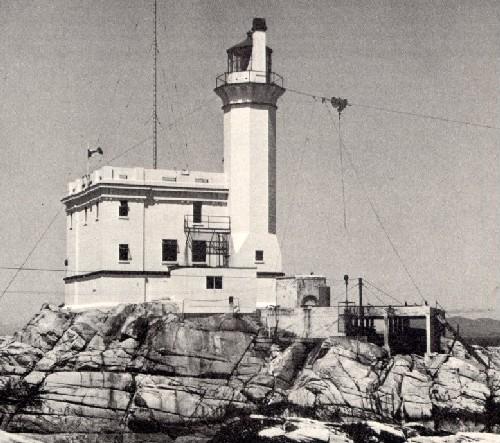
©Parks Canada Agency / Agence Parcs Canada |
Triple Island Lighthouse National Historic Site of Canada
Triple Island, British Columbia
The Triple Island Lighthouse National Historic Site of Canada stands
sentinel on an exposed, rocky islet off the coast of British Columbia.
The concrete, octagonal tower rises from the northeastern corner of an
unornamented, square-shaped keeper's dwelling and fog alarm building. It
is a simplified, well-scaled, classical design occupying a large part of
Triple Island. The strategic location makes it highly visible to
maritime traffic.
The heritage value of this site resides in the physical presence of the
lighthouse as witness to the achievement of its construction on such an
exposed site. The contractor, J.H. Hildritch of Prince Rupert completed
the job in seventeen months without a single loss of life. Triple Island
Lighthouse also illustrates the improvement of aids to navigation on the
west coast of Canada, and was built 1919-1920 to aid marine traffic
using the Inside Passage to Alaska, and ships bound for Prince Rupert.
The lighthouse, with its 3rd Order Dioptric light with a focal plane of
29.5 metres, was a custom design for the site, and was constructed
according to the designs of Col. W. A. Anderson of the Department of
Marine and Fisheries.
|
©Parks Canada Agency / Agence Parcs Canada, 1995 |
Twin Falls Tea House National Historic Site of Canada
Yoho National Park of Canada, British Columbia
Early rustic tea house in Yoho National Park, 1923-24.
Twin Falls Tea House National Historic Site of Canada is located in a
clearing facing Twin Falls Creek near Yoho Glacier in the Upper Yoho
Valley, British Columbia. Built in three sections, this picturesque log
structure provides an outstanding example of rustic design.
Its heritage value lies in its physical illustration of the rustic
design tradition and in its use as a stopping place on a busy hiking
trail in Yoho National Park of Canada. Twin Falls Tea House was built in
association with the Canadian Pacific Railway in three phases: a
one-storey cabin (1908-1910), a two-storey chalet and lodge (1922-23),
and a link between the two units (1925-28). These sections illustrate
log construction methods practiced at different periods within Canada's
national parks.
|

©M. Stopp, Parks Canada Agency / Agence Parcs Canada |
Tse'K'wa National Historic Site of Canada
Fort St. John, British Columbia
Tse'k'wa is an exceptional archaeological site in northeastern British Columbia
that has contributed to the understanding of environmental changes and human
settlement from the end of the last glacial period (12,500 years ago) to 1,000
years ago. Also known as Charlie Lake Cave, it features a sequence of
radiocarbon dated and relatively undisturbed soil layers that is rare in North
America. The site is important for what it has revealed about the earliest
humans and their movement over time, their way of life, about the cultures that
followed, and about post-glacial environmental change.
Tse'K'wa lies in the rolling terrain of the Peace River District to the east of
the Rocky Mountains, nine kilometres northwest of Fort St. John. The site is
within the traditional territory of the Dane-zaa First Nations, and for these
First Nations groups, who are stewards of this site, it is a spiritual place and
a touchstone to their lengthy presence in the Peace River region, to nearby
Charlie Lake, and to the site itself. The site has become an integral element of
Dane-zaa identity and continuing traditions maintained through oral histories,
stories, and songs.
The lowermost soil layers at Tse'K'wa held a combination of undisturbed evidence
of Canada's earliest inhabitants, known by archaeologists as Palaeo-Indian
peoples. This evidence included stone tools and bones of late glacial animals.
Analysis of ancient bison bone remains showed that these animals were hunted,
and the high number of leg bones over other skeletal parts suggests that
preferred meats were brought to this camp from elsewhere. In addition, genetic
analysis of the bison bones has contributed to the understanding of bison
speciation and has helped to understand bison and human migration patterns at
the end of the Ice Age. Two nearly-complete raven skeletons were also found in
lower layers. They may be deliberate interments tied to early belief systems and
may be the earliest such evidence in the country.
The upper soil layers held artifacts and animal bones of cultures that followed,
showing nearly continuous human presence following the Palaeo-Indian period up
to 1,000 years ago. This material has provided key comparative data for the
study of cultural change in western Canada.
|

©City of Victoria, Steve Barber, 2004 |
Union Club of British Columbia National Historic Site of Canada
Victoria, British Columbia
The Union Club of British Columbia is an excellent representative
example of a gentlemen's club. Established in 1879, it is based on a
members-only, private club prototype originating in Britain and
popularized in Canada during the late 19th and early 20th century. Since
1913, the club has been housed in an elegant building in the heart of
Victoria.
Gentlemen's clubs originated in Britain in the 18th century and served
as places where elite men could play games, drink, and enjoy a fine meal
with their peers. These private clubs conferred prestige and status to
their members, who socialized and networked in what were often luxurious
surroundings. In Canada, one of the earliest examples was the Beaver
Club of Montréal, founded by fur merchants and traders in 1785 and
dissolved in 1827. In the 19th century, gentlemen's clubs sprang up in
cities across the country, as local elites sought to recreate the clubs
found in Britain.
After its formation in 1879, the Union Club of British Columbia quickly
developed as a home-away-from-home for politicians, civil servants,
military officers, professionals, and the press. Though members were
barred from engaging in political and business discussions, the founding
of the Union Club may be seen, to some extent, as a political act. The
promise that a transcontinental railway would begin within two years and
be completed within ten was an important condition for British Columbia
joining Confederation in 1871. When it became clear that the Dominion
government would not meet these deadlines, discontent with the political
union grew. Some prominent individuals in Victoria were steadfast in
their support of Confederation. The formation of the Union Club during
this politically turbulent time and its very name reflects the founding
members' stance, in favour of a continued union between Canada and
British Columbia.
Club members met in rented rooms until 1885 when they moved to their
first purpose-built clubhouse. After a wave of prosperity swept Victoria
in the years prior to the First World War and many new members joined,
desire grew to build a new and modern clubhouse. This elegant building,
completed in 1913, has been home to the Union Club ever since. Its
monumentality, symmetry, classical decoration, grand staircase and
prominent site reflect the principles and characteristics of Beaux-Arts
design, a style that dominated public and commercial architecture in the
early 20th century. The club's interior design, layout and appointments
continue to reflect the tastes and interests of its privileged
membership.
|
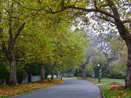
©Dr. Larry McCann |
Uplands National Historic Site of Canada
Oak Bay, British Columbia
Uplands is a residential subdivision of 188 hectares located in the northeastern
section of Oak Bay, the oldest suburban municipality in Greater Victoria.
Designed in 1908 by John C. Olmsted, senior partner at Olmsted Brothers, for
Winnipeg real estate developer William Gardner, it is an exceptional example of
subdivision design and planning and is among the finest works of a renowned
landscape architect. The integrated use of design elements such as a gently
curving street pattern, sensitivity to local topography and flora, large,
irregular lot shapes, ample provision of parks, and the use of protective deed
restrictions helped preserve the subdivision's character and changed the way
suburbs were planned well into the 20th century. The subdivision's heterogeneous
collection of high-quality, architect and builder designed single-family houses
illustrates a variety of trends in Canadian suburban housing, from the Arts and
Crafts to 21st century Neo-Modern styles. Uplands also preserves elements of
First Nations archaeology and landscape practices. Uplands Park contains several
First Nations burial cairns, and the preservation of the Garry oak meadows
within the park and subdivision are attributed, in part, to the seasonal burning
practices of the Songhees First Nation that preceded European colonization.
Uplands contains 600 single-family dwellings housing roughly 2,000 people. Its
idyllic coastal site is bordered by the Salish Sea, the Uplands Golf Course, the
Municipality of Saanich to the north, and Oak Bay to the southeast. Uplands is
among the earliest subdivisions in Canada wholly planned as a residential park —
a group of houses arranged in a pastoral setting. The Olmsted firm designed
Uplands in the tradition of naturalistic or garden suburbs like Llewellyn Park,
New Jersey (1853) and Riverside, Illinois (1869). Novel in Canada at the turn of
the century, the residential park typology proved deeply influential.
Uplands' organic design sits in dramatic contrast with the surrounding
municipalities of Greater Victoria, whose boundaries encompass a patchwork of
gridiron subdivisions with small, rectangular lots. Like other planned
subdivisions in Canada and around the world, Uplands developed in phases. The
first house was completed in 1912, and construction continued until 1976, by
which time every lot had been built on. A number of the houses in Uplands were
designed by Canada's and British Columbia's leading architects.
John Charles Olmsted's respect for local landscapes and his technique of
planning "with the land" had the benefit of preserving elements of First Nations
archaeology and landscape practices. The Garry oak savannahs that John Olmsted
found on site when he first visited in 1907 have successfully been protected and
can be seen in yards, parklets, and in Uplands Park, a large natural park
covering 31 hectares of land deeded by William Gardner to the municipality in
1946.
|

©Parks Canada Agency / Agence Parcs Canada, Kate MacFarlane, 2010 |
Vancouver's Chinatown National Historic Site of Canada
Vancouver, British Columbia
Vancouver's Chinatown National Historic Site of Canada is a distinct
neighbourhood on the east side of downtown Vancouver, British Columbia.
It is centred on Pender Street, between Taylor Street in the West and
Gore Avenue in the East and the lanes north and south of Pender. Its
buildings are characterized by a distinctive hybrid architectural style
that blends aspects of Chinese regional architecture with western styles
and building methods. The main streets follow a traditional 1880s grid
pattern while the north side is distinct to Chinatown with interior
courtyards, passageways, alleys, and main facades that face both streets
and laneways. Constructed to the property lines, the mostly two to four
storeys buildings provide commercial, institutional, and residential
space. The neighbourhood's uniform layout changes on its south side.
Here the large Chinese Cultural Centre is set back, with a large
courtyard leading to the district's largest open public space, the Dr.
Sun Yat-Sen Chinese Classical Garden.
In addition, the heritage value of Vancouver's Chinatown lies in its
ties to the development of the social and cultural life of Chinese
immigrants to British Columbia and Canada, and to the commercial
activities of Vancouver's original business and port districts. The
district is defined by its form, embellishments, layout and
architecture. Incorporated in1886, Vancouver became a major point of
entry for new Chinese immigrants, many of whom settled in Vancouver's
Chinatown. Chinese labourers were granted a 160-acre lease and built
their settlement along Main Street at East Pender. In the early 1900s,
Vancouver's Chinatown became Canada's leading Chinatown, remaining so
until the 1970's. Within the district's streetscapes the 70 contiguous
properties are a mix of commercial, residential and cultural buildings,
alleys and courtyards, many dating from the early 20th century.
Significant newer cultural resources, such as the Dr. Sun Yat-Sen
Chinese Classical Garden and Park (1986), the Chinese Cultural Centre
(1981-86) and the Millennium Gate (2002), enhance the traditional
Chinese character of the area. Protected since 1971 under provincial and
municipal heritage legislation, the area has 24 properties listed on the
Vancouver Heritage Register. Vancouver's Chinatown displays a continuity
and connection to its past, and — as a working urban neighbourhood -
offers lively contrasts between its peaceful public garden, distinctive
buildings and colourful street-life.
|
©Parks Canada Agency / Agence Parcs Canada, Jennifer A. Cousineau, 2018 |
Vancouver Japanese Language School and Japanese Hall National Historic Site of Canada
Vancouver, British Columbia
The Vancouver Japanese Language School and Japanese Hall, located at 487 Alexander Street, was the
first and largest Japanese language school in Canada and one of 50 such schools
in use before 1941. It is a rare surviving example of an interwar language
school in one of British Columbia's oldest immigrant neighbourhoods. During the
Second World War, it was one of thousands of properties confiscated from
Japanese Canadians by the federal government, and is one of very few known
buildings to have been returned to its owners after the period of internment. It
bears witness to the persistence of Japanese Canadians during wartime and
postwar campaigns to recover their possessions and properties. Designed by Sharp
and Thompson, one of BC's most successful architecture firms, this functional
and elegant Art Deco school speaks to the growth, financial success, and
cultural integration of Vancouver's Japanese community in the prewar period, and
manifests the resilience and cultural pride of Japanese Canadians.
The Vancouver Japanese Language School was founded in 1906 and was originally
located at 439 Alexander Street, down the street from the current location. In
the 1920s and 1930s, the Japanese community flourished in Vancouver,
particularly in the Powell Street neighbourhood. Among the community's most
valued organizations were its language schools. Although the majority of
Japanese-Canadian children attended public schools in this period, an immersive
education in Japanese language and culture was given great importance within the
community. In 1928, after successful fundraising efforts, the current building
was constructed to replace the over-crowded original school building. The
school's current Art Deco design reflects the community's economic vibrancy, the
priority accorded to education, and the aspirations of Japanese Canadians in
Vancouver to integration within Canadian society.
During the Second World War, Canada declared war on Japan, and beginning in
February 1942, the federal government forcibly relocated Japanese Canadians
living in BC to internment camps away from the West Coast. The next year, the
government seized all property owned by people of Japanese descent in Canada,
amounting to millions of dollars in farms, land, houses, boats, and commercial,
industrial, and communal institutions. Most of it was sold, never to be
recovered by its original owners. The Vancouver Japanese Language School was
confiscated and used by the Department of National Defence, but was not sold. In
1953, after years of petitioning, the federal government returned the school to
the Japanese Canadian community. Following considerable community fundraising,
the building reopened to the public as a school and community centre, a function
it has retained to this day.
|
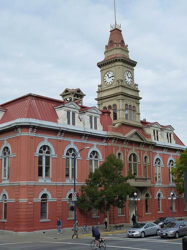
©Parks Canada Agency / Agence Parcs Canada, Andrew Waldron, 2011 |
Victoria City Hall National Historic Site of Canada
Victoria, British Columbia
The Victoria City Hall National Historic Site of Canada is a
two-and-a-half storey brick building designed in the Second Empire
Style. Architectural elements including a prominent central clock tower,
a mansard roof with dormers, and numerous decorative wall features,
reflect the building's intended stature as an enduring monument to civic
pride.
Victoria City Hall was designated a national historic site of Canada in
1977 because it remains one of the best surviving examples of public
architecture in the Second Empire style in western Canada.
Victoria City Hall illustrates Canadians' longstanding desire to create
landmarks as expressions of civic pride and optimism for the future.
Built in three stages between 1878 and 1890 to defray costs, the
building's scale was justified through the accommodation it provided for
a wide range of civic functions including council chambers, municipal
offices, fire hall, public market and jail. A rear annex was added in
1963. The Victoria City Hall continues to affirm the vision of its
builders, both as the seat of local government and as an enduring
architectural landmark.
|

©Parks Canada Agency / Agence Parcs Canada, Andrew Waldron, 2011 |
Victoria's Chinatown National Historic Site of Canada
Victoria, British Columbia
Victoria's Chinatown is an identifiable neighbourhood of tightly built
primarily two and three-storey mixed-use brick buildings in a
three-block area of downtown Victoria, British Columbia. Focussed on
Fisgard Street, its interior is accessed by a distinctive layout of
alleys and passageways. The cohesive grouping of buildings adapts
standard forms found elsewhere in the city, decorated with flared
temple-style roofs, inset and projecting wrought-iron balconies,
interior courtyards and brightly hued tiled overhangs. A ceremonial
entry arch was erected as part of a 1980s revitalization program.
The heritage value of this site is embodied in the diverse collection of
structures within the district, their spatial connections, and ongoing
role in commercial, social and institutional activities of the Chinese
Canadian community. It speaks to the fact that, for nearly three decades
before the Canadian Pacific Railway was completed, Victoria was the
first port of entry of most Chinese immigrants and remained an important
enclave until after World War II.
|
©Vancouver Public Library, Historical Photo Collection, 33461 |
Vogue Theatre National Historic Site of Canada
Vancouver, British Columbia
The Vogue Theatre is an Art Deco-style theatre built for live and
cinematic performances in 1940-1. It is located on Granville Street in
the heart of Vancouver's "Theatre Row".
The Vogue's auditorium relies wholly on the fusion of shapes, massing
and electrical systems for atmospheric effect. Smooth, curving wall
surfaces are not intended solely as aesthetic devices, but also as
acoustical enhancers and as backdrops for the subtle hues cast by the
modulated lighting system. Light shows that simulated sunrises and
sunsets replaced surface decoration as the principal atmospheric device.
In this respect, the Vogue's design heralded a trend in theatre
design.
|
|
Weir's (Taylor's) Beach Earthworks Site National Historic Site of Canada
Metchosin, British Columbia
|
|
Whaler's Shrine Site National Historic Site of Canada
Yuquot, British Columbia
Whaler's Shrine Site National Historic Site of Canada is located on the
southern end of an unnamed island in Jewitt Lake, Nootka Island, in
British Columbia. Situated within Yuquot National Historic Site of
Canada, the site is comprised of the footprint of the original Whaler's
Shrine as it has been determined by archaeological survey. The shrine
itself was dismantled and removed by an American cultural anthropologist
in 1905 and presently resides at the American Museum of Natural History
in New York City. What remains is a heavily forested site in proximity
to the shore of the island, and possibly some archaeological remains.
The heritage value of the Whaler's Shrine Site resides in its historical
associations with Nuu-chah-nulth whaling. According to Mowachaht oral
tradition, whaling was invented in the villages of E'as and Tsaxis. The
inhabitants of these villages were blessed with a special social status
on account of their invention, and eventually the elite Yaluactakamlath
family departed E'as and took control of the village of Yuquot, bringing
the knowledge of whaling with them. The whalers of Yuquot would each
have had a family shrine of some description, typically a simple
clearing or occasionally a small structure. Such shrines were the sites
of purification rituals. These shrines were buildings resembling houses
and containing figures of animals and spirits, as well as corpses and
skeletons. The locations of the shrines were known only to family
members, and particularly, in the case of the shrine owned by the Chief,
none were permitted to approach, much less enter them. The structure,
now known as the Whaler's Shrine or Whalers' Washing House, was the
shrine owned by the Chief and passed down through his family. It is not
known exactly when it was built. It has been warehoused in the American
Museum of Natural History in New York City since the early twentieth
century.
|

©Parks Canada Agency / Agence Parcs Canada, Smyth, 1997 |
Xá:ytem / Hatzic Rock National Historic Site of Canada
Mission, British Columbia
Xa:ytem is a site that includes an archaeological habitation site and an
ancient Sto:lo transformer stone. The identifying feature is the
transformer stone which sits on sloping, low-lying ground, formerly a
beach on the northern banks of the Fraser River.
Xa:ytem was designated of national historic significance because of the
age of the «Hatzic Rock» (sic) habitation site and its close association
to a transformer site of clear importance to the Sto:lo people. The
transformer site is important because it exemplifies the importance of
preserving Sto:lo history, culture, and spirituality.
The heritage value of Xa:ytem resides largely in the spiritual
importance of the transformer rock and its association with the
preservation of Sto:lo history, culture and spirituality. Xa:ytem is a
testament to Sto:lo spirituality and to the survival of the Sto:lo
nation; it is important in the teaching of Sto:lo culture, of the
connectedness to Mother Earth, and of the history and creation of the
Sto:lo people ; and it is a source of spiritual awareness and renewal.
Visible from various vantage points near the site, the transformer rock
is a landmark in the area.
The closely associated habitation site is one of the oldest discovered
(ca. 5000 years). It is valued for its association with Sto:lo history
and culture and for the scientific information it reveals.
|
|
Yan Village Indian Site National Historic Site of Canada
Masset, British Columbia
|
©Parks Canada Agency / Agence Parcs Canada, 2014 |
Yoho National Park of Canada
Headquarters: Field, British Columbia
UNESCO World Heritage Site in Rockies.
These are the western slopes of the Canadian Rocky Mountains. Towering
rockwalls, spectacular waterfalls and soaring peaks earn the park its
name; Yoho is a Cree expression of awe and wonder. Here in the shadow of
the Great Divide are the secrets of ancient ocean life, the power of ice
and water, and the stories of plants and animals that continue to evolve
today.
|
©Parks Canada Agency / Agence Parcs Canada, 1997 |
Yuquot National Historic Site of Canada
Yuquot, British Columbia
Yuquot National Historic Site of Canada is an extensive site located at
Friendly Cove on the remote northwestern coast of Vancouver Island. The
rugged natural setting consists of a dramatic arc of beach along the
water and nearby islands, and a bench of land and forested areas further
back. The site's elements are diverse and include the landscape,
structures, and extensive archaeological remains. The resources are
intimately related to the oral traditions, language, history and place
names of the Mowachaht / Muchalaht First Nations. Official recognition
refers Yuquot village, Yuquot defensive site, the Whalers' Washing
House, the Spanish fort and settlement, the English fur trading
establishment, and the harbour of Friendly Cove; all located within the
boundaries of Indian Reserve #1 of the Mowachaht / Muchalaht First
Nations.
The heritage value of Yuquot lies in its association with the
Mowachaht-Muchalaht First Nations and their social, political and
economic world. Continuously occupied for over 4,300 years, Yuquot
village became the capital for all 17 tribes of the Nootka Sound region.
Whaling was a vital part of the life of the Mowachaht-Muchalaht, and of
all the Nuu-chah-nulth peoples. In the late 18th century, Yuquot also
became an important site of early contact between First Peoples and
European explorers and traders. Explorers were attracted to the security
of the harbour, which they named Friendly Cove. As a result, Yuquot,
also known as Nootka, developed into an important centre of trade and
diplomacy, and it was briefly the site of Spain's only military
establishment in present-day Canada. Yuquot additionally became the
focal point of the Nootka Sound Controversy of 1789-1794, when the rival
interests of Great Britain and Spain brought those countries to the
brink of war.
|
|