|
Park Summaries
Nunavut
All text and photos are copyrighted by Parks Canada or the Canadian Register of Historic Places
(except as noted) and were extracted from either the Parks
Canada or Canada's Historic Places
Websites. Parks with a grey background are managed by Parks Canada.
©Parks Canada Agency / Agence Parcs Canada |
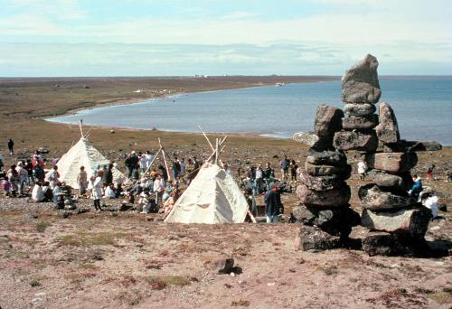
Arvia'juaq and Qikiqtaarjuk National Historic Site of Canada
Arviat and Sentry Islands, Nunavut
This national historic site is comprised of two portions: Arvia'Juaq and
Qikiqtaaruk. Arvia'Juaq is a traditional summer camp of the Paallirmiut
Inuit. It is a 5-km long island with two sections joined by an isthmus,
and is located 8 km from the Hamlet of Arviat on the western shore of
Hudson Bay. Situated in an area rich in marine wildlife resources, the
island contains many ritual and spiritual sites.
Qikiqtaarjuk is a point of land projecting into Hudson Bay from the
mainland immediately opposite Arvia'Juaq. It was once a small island and
is now joined to the mainland by a narrow strip of land. Rich in
evidence of human habitation, it contains tent rings, food caches, kayak
stands and graves from the summer occupancy of generations of
Paallirmiut. A sacred site associated with the legend of Kiviuq is
located at the end of the peninsula.
The heritage value of Arvia'Juaq and Qikiqtaarjuk National Historic Site
lies in the wholeness and completeness of this cultural landscape, in
the continuity of human habitation that they witness, and in the rich
cultural, spiritual and economic role they play in the lives of the
Inuit of the Arviat area. Heritage value is embodied in the natural
features and resources of the land, in all evidence of human habitation
and patterns of Inuit occupancy, and in the ritual and spiritual
properties of the many sacred sites.
For centuries the Inuit of the Arviat area have returned to Arvia'Juaq
and Qikiqtaarjuk each summer to camp and harvest the abundant marine
resources. These gatherings provided an opportunity to teach the young,
celebrate life, and affirm and renew Inuit society. The oral histories,
traditional knowledge and archaeological sites at Arvia'Juaq and
Qikiqtaarjuk provide a cultural focus for future generations since they
continue to be centres to celebrate, practise and rejuvenate Inuit
culture.
|
©Parks Canada Agency / Agence Parcs Canada |
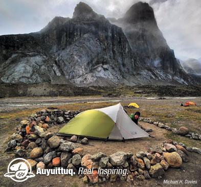
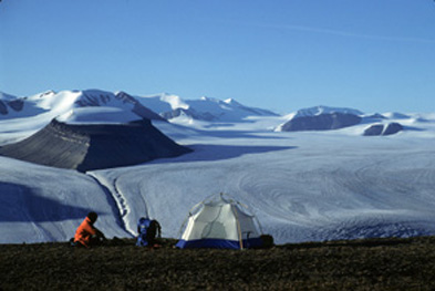
Auyuittuq National Park of Canada
Headquarters: Pangnirtung, Nunavut and Qikiqtarjuaq, Nunavut
Baffin Island landscapes containing northern extremity of Canadian Shield.
Sweeping glaciers and polar sea ice meet jagged granite mountains in
Auyuittuq National Park of Canada. Established in 1976, Auyuittuq - an
Inuktitut word meaning "land that never melts" - protects 19,089 km 2 of
glacier-scoured terrain. Located in the eastern Arctic, on southern
Baffin Island, the park includes the highest peaks of the Canadian
Shield, the Penny Ice Cap, marine shorelines along coastal fiords, and
Akshayuk Pass, a traditional travel corridor used by the Inuit for
thousands of years. Whether you wish to climb Auyuittuq's rugged peaks,
ski on its pristine icefields, or hike the scenic Akshayuk Pass, this
park offers unique opportunities to experience the beauty and majesty of
the Arctic.
|

©Parks Canada Agency / Agence Parcs Canada |
Beechey Island Sites National Historic Site of Canada
Beechey and Devon Islands, Nunavut
Beechey Island Sites National Historic Site of Canada is located
primarily on Beechey Island, a peninsula connected to Devon Island, in
the Arctic Archipelago of Nunavut. It is a bare, windswept island, which
rises to a small hill, fringed by a narrow beach. This setting provided
suitable flat and sheltered land for Arctic expeditions. The site is
comprised of five archaeological sites on Beechey Island, and Devon
Island and in the nearby sea, namely the Franklin wintering camp of
1845-46, Northumberland House, the Devon Island site at Cape Riley, two
message cairns and HMS Breadalbane National Historic Site of Canada.
Beechey Island Sites is associated with the exploration of Canada's High
Arctic. Over the years, many different ship crews wintered here,
beginning with Sir John Franklin's team in 1846-47. The party wintered
on Beechey Island during its search for a Northwest Passage, but became
icebound off King William Island the next year. All eventually perished,
leaving scanty records of the exploration. As a result of their
disappearance, Franklin's expedition became the cause of a massive
survey and exploration of a large portion of the Canadian Arctic.
Beechey Island was used as a base and supply depot for these expeditions
for the next decade. The search led to further significant discoveries,
including the discovery of three Northwest Passages and the mapping of
half of the Canadian Arctic. This flurry of activity left a large number
of archaeological resources on the island and in the waters adjacent,
ranging from cairns and graves to the ruins of wooden buildings and the
wreck of HMS Breadalbane.
|

©Library and Archives Canada / Bibliothèque et Archives Canada, A.P. Low, 3406600, 1903 |
Blacklead Island Whaling Station National Historic Site of Canada
Blacklead Island, Nunavut
Blacklead Island Whaling Station National Historic Site of Canada is
located on Blacklead Island in Nunavut in the Canadian Arctic
Archipelago. Blacklead Island was used by the Inuit as a winter camp and
for whaling, and later by Europeans. Situated in the south of Cumberland
Sound, the site is comprised of three archaeological sites on the
Blacklead, Niantilik and Cemetery Islands, the shipwrecks off
Aagotirpazask Island, and the archaeological site at the forks of
Ptarmigan Fiord.
Blacklead Island Whaling Station was the site of two permanent whaling
outposts dating from the middle of the 19th century. Similar sites were
established at roughly the same time at Kekerton Island, and on Hall
Peninsula, Baffin Island. An Anglican mission was built at Blacklead in
1895. In 1921, the Hudson's Bay Company built a post at Pangnirtung and
a Royal Canadian Mounted Police post was established two years later. As
Inuit communities living at Blacklead and at Kekerton began to
congregate at Pangnirtung, the whaling stations were eventually
abandoned.
|

©Parks Canada Agency / Agence Parcs Canada |
Bloody Falls National Historic Site of Canada
Kugluk/Bloody Falls Territorial Park, Nunavut
Bloody Falls National Historic Site of Canada is located within Kugluk /
Bloody Falls Territorial Park, on the western shore of the Coppermine
River, in Nunavut. The site encompasses pre-contact Aboriginal
encampments set on river terraces along the broad, swift-flowing river.
These encampments, of which there are no extant remains, were used as
Aboriginal hunting and fishing stations for over three millennia, dating
to 1700 B.C.E.
The archaeological remains found at Bloody Falls represent the
occupations of several Aboriginal and Inuit peoples, spanning thousands
of years. Material deposits were documented from the Thule occupation
period circa. (1000-1500 B.C.E.). Beneath the bottom-most Thule layer of
cultural deposits, Pre-Dorset (also referred to as the Arctic Small Tool
Tradition) cultural material was discovered, dating from between 1700
and 1500 B.C.E. The location, away from the coast in the interior,
served as a staging area for forays to hunt, fish and to obtain native
copper.
In addition to the Thule houses, 10 pre-contact and historic Aboriginal
encampments were recorded to the northern end of the site. These
encampments yielded stone and bone artifacts from the pre-contact
period, dating to 160 C.E. Also documented at the site were materials
relating to the early historic occupation of Copper Inuit.
|
©Parks Canada Agency / Agence Parcs Canada, 2000 |
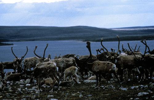
Fall Caribou Crossing National Historic Site of Canada
Kivalliq Region, Nunavut
Fall Caribou Crossing National Historic Site of Canada spans a section
of the lower Kazan River (Harvaqtuuq) between the Kazan Falls and the
narrows in Thirty Mile Lake (Quukilruq) in the Territory of Nunavut. In
this area, the river has an east-west orientation, and is relatively
narrow with gently sloping shorelines. The entire area is criss-crossed
with extensive caribou trails.
The heritage value of Fall Caribou Crossing National Historic Site of
Canada lies in its witness to centuries of inland Inuit caribou hunt in
a cultural landscape with particular natural geographic features,
abundant evidence of human occupation associated with the caribou hunt,
and animated by oral histories, cultural traditions and archaeological
patterns related to long term inland Inuit use, maintenance and
activity. For centuries, the fall caribou crossing on the Kazan River
was essential to the inland Inuit, providing them with the necessities
of daily life and the means to survive the long winter. Once in the
water, the caribou were vulnerable to hunters in kayaks who caught and
lanced as many as possible. The Inuit cherished and cared for the land
at the crossing areas in accordance with traditional beliefs and
practices to ensure that the caribou returned each year during their
southward migration. To inland Inuit, the caribou was the essence of
life. All parts were valuable for food, fuel, tools, clothing and
shelter.
|

©Parks Canada Agency / Agence Parcs Canada |
Igloolik Island Archaeological Sites National Historic Site of Canada
Igloolik Island, Nunavut
Igloolik Archaeological Sites National Historic Site of Canada consists
of nine archaeological sites found on Igloolik Island, located on the
north-western shore of Foxe Basin, in Nunavut. These sites, located on
the island's raised beaches, date from Dorset and Pre-Dorset occupations
from as early as 2000 BCE.
Igloolik Island has been home to Arctic peoples for thousands of years.
Archaeological evidence places human activity on the island as early as
2000 BCE, when the Pre-Dorset peoples were attracted to the area due to
its excellent fishing and sea mammal hunting. Later occupations include
both Dorset and Thule. Archaeological research at the island has
provided one of the most complete archaeological sequences in Arctic
Canada. Today, the village of Igloolik occupies a portion of the western
section of the island.
In the early 1800s, Igloolik Island served as the wintering site of the
explorer Edward Parry. Captain of the Fury, Parry was one of several
explorers searching for a western passage through the Arctic. During his
second year of exploring the northern reaches of the Hudson Bay, he and
his crew wintered at Igloolik, where they were in contact with the
island's Inuit population. Over a century later, the anthropolgist Knud
Rasmussen based his Fifth Thule Expedition (1921-1924) at Igloolik
Island. This anthropological expedition was a wide ranging examination
of several arctic cultural groups, and the monographs produced from
Rassmussen's research are still considered some of the most important
work in the areas of Arctic archaeology, physical anthropology and
ethnography.
|

©Lee Narraway, Summer 2008 |
Inuksuk National Historic Site of Canada
Enukso Point, Nunavut
Inuksuk National Historic Site of Canada is situated on the Foxe
Peninsula, approximately 88.5 km from Cape Dorset on the Southwest of
Baffin Island, Nunavut. Set on the shore of the Northwestern Passages
the site is situated above the high-tide line of the western and eastern
sides of Enukso Point. The inuksuit, stone cairns, stand on the
headland, a treeless, rocky hill sloping towards the sea. Two groups of
Inuksuit exist on this site, approximately 100 of which remain standing.
The two groups are set 465 feet apart and the southern cluster is 200
feet across. The Inuksuit consist of carefully piled stones placed to
form cairns that can be complex, as large as 6 to 7 feet in height,
sometimes figure-like, while smaller inuksuit may be composed of two
balanced stones or single standing stones. The grouping of cairns may
have been built as long as two thousand years ago.
The heritage value of Inuksuk derives from its scientific, social and
spiritual importance. Inuksuk is a word that translates as "likenesses
of men." Collectively known as Inuksuit, the cairns are composed of
carefully placed and selected stones. These constructions are found
across the north individually and in groups. They are purposely created
and depending on size and location may fill a variety of roles including
landmarks situated on hilltops, cache markers for meat, memorials, kayak
stands, pillars supporting drying lines, or elements of caribou fences,
as well as ceremonial or spiritual roles. Their composition can vary
from a single vertically set stone to complex monuments, some of which
at this site reach 7 feet in height. This site contains nearly 100
cairns. The Inuksuit provide a testament to the hard-labour and
creativity of the Inuit people who inhabited the North and were able to
make use of the resources of their environment in an ingenious and
artistic manner.
|

©Library and Archives Canada / Bibliothèque et Archives Canada, G. Drinkwater, C-084687, 1897 |
Kekerten Island Whaling Station National Historic Site of Canada
Cumberland Sound, Nunavut
Kekerten Island Whaling Station is located in northern Cumberland Sound,
in Kekerten Harbour, Nunavut. In the Canadian Arctic Archipelago, the
site is spread across three islands, and comprises the remains of a
whaling station, as well as a burial ground and a shipwreck. The grassy
slopes adjacent to the sheltered harbour served as three hilltop
lookouts for signs of whale activity, and were located between the
shoreline and the rocky high ground to the south.
Kekerten Island was the site of two adjacent whaling outposts, operated
by Americans and Scots, in the latter half of the 19th century. Along
with Blacklead Island, it was the most important whaling station in the
Cumberland Sound from between 1860 to 1880, during the height of Bowhead
whaling. The sloped terrain and rocky high ground offered good lookout
posts from which the Sound could be surveyed for signs of whales.
Whalers who died at the station were buried in the nearby Penny's
Burying Ground.
The ship-wintering site attracted many of the aboriginal inhabitants
from the surrounding area, and the culture of the Inuit became adapted
more and more to the rhythm of the whaler's year. The ships' captains
assumed responsibility for providing imported provisions for hired Inuit
and their families, and the trading of firearms, ammunition, telescopes
and even whaleboats became an important event at the end of the whaling
season. Kekerten was abandoned around 1923 after a decline of whaling
and Inuit activity at Kekerten Station in favour of nearby Pangnirtung,
an outpost established by the Royal Canadian Mounted Police.
|

©Canadian Museum of History / Musée canadien de l'histoire |
Kodlunarn Island National Historic Site of Canada
Frobisher Bay, Nunavut
Kodlunarn Island National Historic Site of Canada is situated on
Kodlunarn Island in Frobisher Bay, 190 km from Iqaluit. Ruins of a stone
house, earthworks and mining excavations created during Elizabethan
explorer Martin Frobisher's gold mining expeditions can still be seen on
its shores.
The heritage value of Kodlunarn Island National Historic Site of Canada
lies in its association with the mining attempts of Martin Frobisher as
illustrated by the site and the archaeological evidence it retains to
confirm Frobisher's 16th-century presence and activities. Evidence also
survives in the oral traditions of the Inuit people who have preserved
an account of this first European attempt to exploit the natural
resources of the Arctic.
Kodlunarn Island was the site of mining expeditions by British explorer
Martin Frobisher during the summers of 1576, 1577, and 1578. Like his
predecessor John Cabot, Frobisher was searching for a northwest passage
when he found what he thought was gold. His vessels returned to the
Arctic for three consecutive years to remove some 1400 tons of worthless
ore from several mines. They remained for a period of four to five weeks
each of year, exploring the area and making landfalls to extract ore.
One of the major sites they visited was Kodlunarn Island, also known as
Qallunaat, White Man's Island, and Countess of Warwick Island, where
Frobisher planned to leave a large party to mine during the winter of
1578-79. Although his plan was never realized, he did build a stone
house for accommodation. Today the ruins of this house together with
various excavations, earthworks and scattered artifacts remain on the
island. Archaeological expeditions carried out preliminary surveys of
the locations related to Frobisher on this island in the 1970s and
1980s.
|
|
Port Refuge National Historic Site of Canada
Grinnell Peninsula, Nunavut
Port Refuge National Historic Site of Canada is located in a small bay
off the south coast of Grinnell Peninsula, on Devon Island, Nunavut. The
site is comprised of two parcels of land: one is located on raised
terraces on the western and northern shores of the port, and the other
is located at Cape Hornby on the eastern shore of the harbour. Contained
within these parcels are a series of archaeological sites dating to
prehistoric occupation, including a Thule winter village near the
entrance of the bay, and remains of Pre-Dorset dwellings. More recent
cairns and markers dot the landscape around the gravel beaches.
Port Refuge contains well-preserved archaeological evidence of early
human occupation of the High Arctic on raised beaches, which range in
elevation from 15 to 25 metres above sea level. Archaeological remains
are visible on the surface around the bay, and are irregularly
distributed over an area approximately 900 hectares in size. The area
contains a very rich series of pre-contact occupations beginning with
the Independence I occupation (2000 B.C.E.), and continuing to the Thule
Inuit occupation (1200 to 1500 C.E).
Structures that were excavated provide valuable information concerning
spatial and elevational groupings. In addition, the variety of features
including objects of Norse and Asiatic origins found at the Thule winter
village near the entrance of the bay show evidence of trade with
medieval Norse colonies of Greenland.
The most recent remains of occupation at the site exist from Sir Edward
Belcher's 1852-1853 voyage in search of the missing Franklin Expedition.
Forced by ice to remain in the bay for several days, he erected survey
and marker cairns which now remain as several small hills.
|
©Parks Canada Agency / Agence Parcs Canada |
Qausuittuq National Park of Canada
Headquarters: Resolute, Nunavut
High Arctic national park, formally enshrining the northern part of
Bathurst Island.
The approximately 11,000 square kilometres of Arctic lands and waters
protected in Qausuittuq National Park include the northern part of
Bathurst Island as well as the Governor General Islands to the west, and
smaller islands west and north of Bathurst Island. Seymour Island
Migratory Bird Sanctuary is to the north, while the southern boundary of
Qausuittuq National Park borders on Polar Bear Pass National Wildlife
Area.
The national park includes marine areas in May and Young Inlets, and
land that rises from the sea in impressive bluffs. Landscape features
range from wetlands and lowlands to plateaux, hills and uplands with
elevations up to 411 metres. Underlain by sedimentary rocks such as
limestone, sandstone and dolomite, the land shows evidence of past
glaciations in landforms such as eskers, moraines and raised beaches.
At 76° north latitude, Bathurst Island is located in one of the coldest
and driest regions in the world with temperatures averaging minus 32° C
in January and only 5° in July. Annual precipitation is less than 130
mm. This severe climate limits soil development and vegetation is
sparse. Patches of purple saxifrage, dwarf willow, sedges, grasses,
lichens and mosses provide a precious food source for wildlife.
In spite of the high latitude and harsh conditions, there is a
surprising number of species of wildlife inhabiting the area. Qausuittuq
National Park protects key wildlife habitat including travel routes,
calving grounds and wintering grounds for Peary caribou. The park is
also a significant area for muskoxen. Other species adapted to this
environment include polar bear, arctic wolf, arctic fox, and numerous
birds such as snowy owl, snow goose, king eider, jaegers, gulls and
shorebirds. Some of the marine species in the area include ringed seal,
bearded seal, walrus, bowhead whale, beluga whale and narwhal.
Archaeological studies have found evidence of human use on Bathurst
Island dating back 4500 years. Pre-Dorset, Dorset and Thule Inuit
cultures were present in the area, although most sites are to the south
or the east of the national park. Within Qausuittuq National Park, there
are several archaeological sites relating to the Late Dorset culture
(ca. 500 to 1200 AD) along Bracebridge Inlet.
Beginning in 1819, a series of British naval expeditions in search of
the Northwest Passage explored in the Bathurst Island area. Later
expeditions came searching for HMS Erebus and HMS Terror, Sir John
Franklin's ships that disappeared after 1845. Between 1850 and 1854,
naval search parties put up cairns and supply depots on the islands
north of Bathurst Island, within Qausuittuq National Park, including an
impressive cairn on Helena Island.
Exploration in the Bathurst Island area continued into the twentieth
century. Captain Joseph-Elzéar Bernier led three expeditions between
1906 and 1911 with the goal of establishing Canadian sovereignty over
the Arctic islands. Other Canadian government expeditions followed,
including RCMP patrols, RCAF magnetic pole research flights; photography
over-flights; as well as surveys of wildlife, geology and hydrology. The
1960s and 1970s brought exploratory drilling for oil and gas and
minerals to the area. Various research projects continue to this day,
many supported by the Polar Continental Shelf Program.
|
©Parks Canada Agency / Agence Parcs Canada |
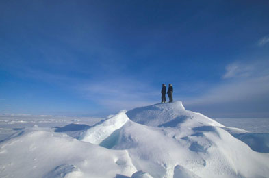
Quttinirpaaq National Park of Canada
Headquarters: Iqaluit, Nunavut
Most remote, fragile, rugged and northerly lands in North America.
During the brief arctic summer on Quttinirpaaq, the sun remains high in
the sky bathing the land in continuous daylight. There is no darkness to
mark the passage of time telling you when to sleep and when to wake.
There are no trees to remind you of lands further south. The scale of
the land is both immense and intimate at the same time. Intricate
patterns of rock, frost-cracked ground, willows and wildflowers at your
feet extend out from where you stand into endless vistas in the clear,
dry air. Glaciers on a mountainside 15 km away seem to be details in a
landscape within reach.
|
©Parks Canada Agency / Agence Parcs Canada |
Sirmilik National Park of Canada
Headquarters: Pond Inlet, Nunavut
Northern Baffin Island landscape containing Eastern Arctic Lowlands and Lancaster Sound.
As part of Canada's national parks system, Sirmilik National Park
represents the Northern Eastern Arctic Lowlands Natural Region and
portions of the Lancaster Sound Marine Region. The park will comprise
three separate land areas. Bylot Island is a spectacular area of rugged
mountains, icefields and glaciers, coastal lowlands and seabird
colonies. Oliver Sound is a long, narrow fiord with excellent
opportunities for boating, hiking and camping. Borden Peninsula is an
extensive plateau dissected by broad river valleys. The park features
landforms and superb wilderness hiking and camping, and a major seabird
colony in the vicinity of Baillarge Bay.
|
©Parks Canada Agency / Agence Parcs Canada |
Ukkusiksalik National Park of Canada
Headquarters: Repulse Bay, Nunavut
The place where there is stone that can be used to carve pots and oil lamps.
Ukkusiksalik National Park is located just west of the community of
Repulse Bay and south of the Arctic Circle. The park surrounds Wager
Bay, a 100 km long saltwater inlet on the northwest coast of Hudson Bay
in Nunavut. Declared a national park on August 23, 2003, Ukkusiksalik
became Canada's 41st national park. Named after the soapstone found
within its boundaries, the park includes 20 500 km2 of eskers, mudflats,
cliffs, rolling tundra banks and unique coastal regions. While Inuit do
hunt in the region, the parkland is uninhabited. Inuit had lived in the
area from 1000 AD through to the 1960s, and the Hudson's Bay Company had
a trading post there from 1925-1947. Over 500 archaeological sites have
been identified in the park, including such features as fox traps, tent
rings, and food caches. The park protects a representative sample of the
Central Tundra Natural Region.
|

©Parks Canada Agency / Agence Parcs Canada |
Wreck of HMS Breadalbane National Historic Site of Canada
Beechey Island, Nunavut
Wreck of HMS Breadalbane National Historic Site of Canada is
located off Beechey Island, Nunavut well above the Arctic Circle and is
the most northerly known shipwreck. The site is comprised of the
wreckage of HMS Breadalbane, a 19th-century, 500-ton sailing
ship, including the hull, fragments of the vessel and the debris field
caused by the sinking of the ship. The shipwreck is also a component of
Beechey Island Sites National Historic Site of Canada.
HMS Breadalbane was built in 1843 in a shipyard on the Clyde
River in Scotland. It spent the first few years of its existence as a
merchant vessel, travelling as far as Calcutta. After the disappearance
of Sir John Franklin's expedition, which was searching for the Northwest
Passage, HMS Breadalbane was pressed into service by the British
Admiralty to supply the vessels which were exploring the Arctic waters
in search of Franklin and his crew. It left the Thames River in 1853,
accompanying HMS Phoenix, and arrived at the rallying point for
the search parties at Beechey Island later that year. However, the
Arctic weather did not co-operate and HMS Breadalbane soon found
itself surrounded by slow-moving yet implacable pack ice. The ship was
quickly emptied of as many supplies and personal effects as possible. On
the night of August 20-21, the ice finally broke through the hull,
sinking HMS Breadalbane to the floor of Barrow Strait.
|

©Parks Canada Agency / Agence Parcs Canada |
Wrecks of Erebus and Terror National Historic Site of Canada
Erebus Bay, King William Island, Nunavut
In 1845, Captain Sir John Franklin sailed from the United Kingdom in
search of a Northwest Passage through what is now the Canadian Arctic.
He and his crew travelled aboard the 370-tonne HMS Erebus and the
340-tonne HMS Terror, each of which had been refitted and strengthened
for polar service and contained equipment to conduct zoological,
botanical, magnetic and geologic surveys. Originally designed as
sail-powered naval mortar bomb vessels, these wooden ships were of
extremely strong construction. For Franklin's expedition the vessels
were fitted with iron sheathing at the bow and equipped with a
20-horsepower steam engine and a single screw propeller, capable of
moving the ships at 4 knots.
Other than a chance encounter with a whaling vessel in 1845, Franklin,
his crew and his vessels were never seen again. There were several
unsuccessful search and rescue operations; however, no news of the crew
was discovered until fifteen years later. In 1859, Captain William
Hobson of HMS Fox found a message in a cairn on King William Island. The
message gave the locations of HMS Erebus and HMS Terror and stated that
in 1846 the crews were preparing to over-winter while the ships were
lodged in pack ice. There was also a message penned by the captain of
Terror and dated 17 months later. He recorded that the ships had been
stuck in the ice for a year-and-a-half, and that Franklin and several
crew members had perished. The survivors were making for Back's Fish
River, to the southeast, but were never heard from again. Captain Sir
John Franklin was designated as a person of national historic
significance in 1945 because of his explorations in the Canadian Arctic
during the 19th century.
In 2014, the remains of the HMS Erebus were found in the eastern
stretches of the Queen Maud Gulf off the western coast of the Adelaide
Peninsula. In 2016, Arctic Research Foundation discovered the remains
of the HMS Terror in Terror Bay on the southwest side of King
William Island, Nunavut.
|
|