|
Park Summaries
New Brunswick
All text and photos are copyrighted by Parks Canada or the Canadian Register of Historic Places
(except as noted) and were extracted from either the Parks
Canada or Canada's Historic Places
Websites. Parks with a grey background are managed by Parks Canada.
©Parks Canada Agency / Agence Parcs Canada, HRS 0544, 1993 |
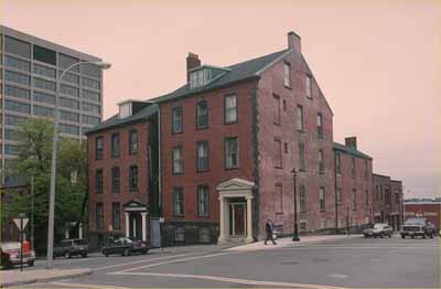
1 Chipman Hill National Historic Site of Canada
Saint John, New Brunswick
1 Chipman Hill is a mid-19th-century brick townhouse. It is located at
the top of Chipman Hill in the historic section of downtown Saint
John.
1 Chipman Hill was designated a national historic site in 1984 because
of the scale and variety of the illusionist paintings in its
interior.
The interior of 1 Chipman Hill provides a rare and early example of the
type of artistic wall and ceiling paintings favoured in affluent homes
in late 19th century domestic interiors of the affluent middle class.
Likely created in the 1870s, the paintings reflect the High Victorian
taste for painted illusions of textures and depths, imitations of
materials, and revivals of historical motifs.
|
©Parks Canada Agency / Agence Parcs Canada, 1987 |
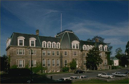
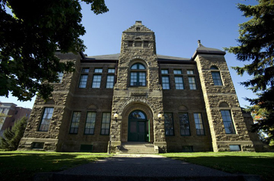
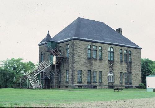
Arts Building National Historic Site of Canada
Fredericton, New Brunswick
The Arts Building is a large, three-storey, classically inspired masonry
structure located on College Hill, at the centre of the picturesque,
hillside, campus of the University of New Brunswick. Noted as the oldest
university building in Canada still in continuous use, the Arts Building
overlooks the city of Fredericton and the Saint John River.
The Arts Building was designated a national historic site in 1951
because it is the oldest university building in use in Canada.
The heritage value of the site resides in its historical associations
with the beginnings of tertiary education in Canada as illustrated by
its site, design and materials. The Arts Building was built in 1826-8
for King's College, a post-secondary institution that became the
University of New Brunswick in 1860. The building opened and the first
classes were held there in 1829. A mansard roof providing the building
with a third storey was added in 1876. For many years the building
housed the offices and living quarters of the university president. It
is presently used by the University of New Brunswick as administrative
offices.
The building is also known as Sir Howard Douglas Hall, so-named in
honour of Sir Howard Douglas (1776-1861), Lieutenant Governor of New
Brunswick and founder of King's College, who spearheaded the
construction of the Arts Building in the 1820s.
|
©Parks Canada Agency / Agence Parcs Canada, 2001 |
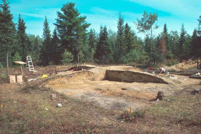
Augustine Mound National Historic Site of Canada
Metepenagiag Mi'kmaq Nation, New Brunswick
Augustine Mound National Historic Site is an archaeological site located
within the reserve land of the Metepenagiag Mi'kmaq Nation, New
Brunswick, on the north side of the Little Southwest Miramichi River
across from the present Mi'kmaq community. It includes a circular ritual
site surrounding a slightly elevated burial mound that sits on low
terrace near the junction of the Northwest and Little Southwest
Miramichi Rivers. Augustine Mound National Historic Site of Canada is
located 700 metres east of the Oxbow National Historic Site of
Canada.
The heritage value of Augustine Mound NHSC lies in its longstanding
connection to a distinctive religious phenomenon rarely seen in eastern
Canada, and in its longstanding connection with spiritual and community
life in Mi'kmaq culture as illustrated by its setting, site, form and
composition, the nature of the archaeological evidence its mound
contains, and in its long term role as a sacred site.
Augustine Mound National Historic Site is a ceremonial burial mound
created around 2,500 years ago. It is an eastern manifestation of the
Adena burial tradition centred in the Ohio Valley. The site consists of
a circular area approximately 30 m. in diameter centred on a low mound,
surrounded by a circular ceremonial area. It contains human remains and
archaeological artifacts. Originally excavated in 1975-76, only part of
the mound remains undisturbed. This is in the form of two perpendicular
ridges (baulks) in the form of a cross centred on the mound. Oriented to
the cardinal directions, each baulk is approximately 1 metre wide and
10-11 metres long and rises from ground level to a height of 0.5 metre
in the centre. The centre portion of the mound was disturbed just prior
to the archaeological work. The site retains a spiritual significance
and ritual place in the life of the Mi'kmaq community.
|
©Parks Canada Agency / Agence Parcs Canada, 2001 |
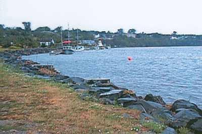
Beaubears Island Shipbuilding National Historic Site of Canada
Beaubears Island, New Brunswick
Archaeological site associated with nineteenth-century shipbuilding in
New Brunswick.
Boishébert National Historic Site of Canada and Beaubears Island
Shipbuilding National Historic Site of Canada & J. Leonard O'Brien
Memorial are administered by Parks Canada in collaboration with the
Friends of Beaubears Island. The island, located on the Miramichi River
45 minutes north of Kouchibouguac National Park of Canada and 45 minutes
south of the City of Bathurst, retains an old growth Acadian Forest with
200-year-old White Pines.
Boishébert Island and nearby Wilson's Point together form Boishébert
National Historic Site of Canada. Under the leadership of Charles
Deschamps de Boishébert, many Acadians found refuge during the
Deportation at Wilson's Point from 1756 to 1760. Boishébert Island was
also an integral and functional part of the early settlement, which
gives testimony to the Acadian experience. Prior to Acadian settlement
in the region, the Mi'kmaq people camped on the island and were one with
the spirit of the land.
Beaubears Island Shipbuilding National Historic Site of Canada, J.
Leonard O'Brien Memorial, is the only known, undisturbed archaeological
site associated with the national significance of the 19th century
wooden shipbuilding industry in New Brunswick.
Beaubears Island Shipbuilding National Historic Site of Canada
incorporates some 24 hectares (60 acres) on the southeastern
(downstream) shore of Beaubears Island at the confluence of the
Southwest and Northwest Miramichi River, and the adjacent south channel
of the Miramichi River. The site includes the remains of an early
19th-century shipyard.
Beaubears Island Shipbuilding was designated a national historic site as
an example of a shipbuilding site in the Province of New Brunswick that
contained in situ archaeological resources.
The heritage value of Beaubears Island Shipbuilding lies in the setting
and landscape which contains archaeological resources defining the
former shipyard facilities. These are typical of a New Brunswick
shipyard of the early and mid 19th century in an area representing the
major concentration of such sites along the Miramichi, the second
largest shipbuilding centre in New Brunswick.
|
©Canadian Inventory of Historic Buildings/ Inventaire des bâtiments historiques du Canada, ca.1975 |
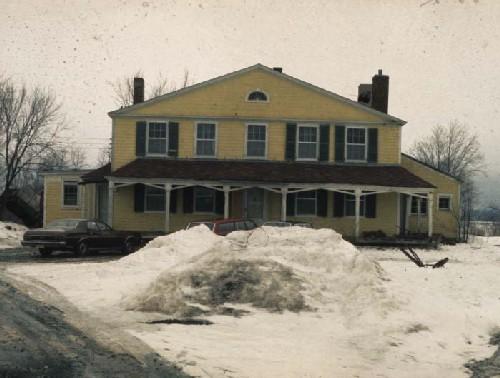
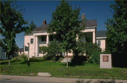
Belmont House / R. Wilmot Home National Historic Site of Canada
Lincoln, New Brunswick
Belmont House / R. Wilmot Home National Historic Site of Canada is a
large neoclassical country house built in the early 19th century. It is
located on the southwest bank of the Saint John River, about 16
kilometres from the city of Fredericton.
Belmont House / R. Wilmot Home is a good example of the neoclassical
style as it was interpreted in Canada between 1820 and 1830. Its façade,
whose form is created by the roof's gable end, is designed to emulate a
temple front. Repeated on the rear elevation, the temple front
arrangement, symmetry and classical ordering of the façades reflect the
strength of neoclassicism in Canadian domestic architecture during this
period.
Robert Duncan Wilmot (1809-1891), a Father of Confederation and
prominent local, provincial and federal politician and statesman, lived
at Belmont House intermittently between his father's purchase of the
property in 1839 and his own death in 1891.
|
©Parks Canada Agency / Agence Parcs Canada
©Parks Canada Agency / Agence Parcs Canada, Ian Doull, 1999 |
Boishébert National Historic Site of Canada
Beaubears Island, New Brunswick
Acadian refugee settlement, 1756-59.
Boishébert National Historic Site of Canada is a wooded area with
archaeological evidence of an 18th century Acadian refugee camp situated
on Wilsons Point and Beaubears Island at the confluence of the Southwest
and Northwest Miramichi River in New Brunswick.
The heritage value of Boishébert lies in the landscapes which includes
below-ground cultural resources of the settlement of refugee Acadians,
historic viewplanes and a relatively undisturbed natural setting.
|
©Parks Canada Agency / Agence Parcs Canada

©Parks Canada Agency / Agence Parcs Canada |
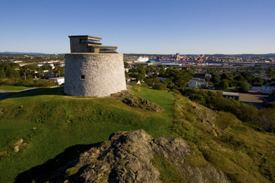
Carleton Martello Tower National Historic Site of Canada
Saint John, New Brunswick
Fortification built to defend Saint John during War of 1812.
Carleton Martello Tower dates from the War of 1812 and played a pivotal
role in conflicts up until the Second World War. The site features a
restored powder magazine, a restored barracks room, and exhibits in the
tower and in the Visitor Centre. Visitors will also marvel at the
spectacular view of the city of Saint John and its harbour.
Carleton Martello Tower National Historic Site of Canada is a round,
stone defence tower erected on a steep, rocky open ground. It is located
on Carleton Heights across the harbour from downtown Saint John, New
Brunswick.
The heritage value of Carleton Martello Tower lies in its construction
origins. It was built by the British government between1812 and 1815 to
protect Saint John from an American land attack from the West, during
the War of 1812. The tower was briefly used for military purposes during
World War I.
The heritage value of Carleton Martello Tower also lies in its
architectural significance. The original structure is representative of
the type of coastal defence used by the British inter alia in the
British Isles during the Napoleonic period, in the late 18th and early
19th centuries. The tower is constituted of round walls, thick at the
base, gradually tapering and slopping inward toward the ceiling. A
two-storey addition was built on top of the tower in 1941 and it
accommodated Saint John harbour defence facilities until 1948.
The heritage value of Carleton Martello Tower lies in its strategic
location. Located 68.5 metres above sea level, on Carleton Heights, the
tower was erected on the height of land in West Saint John. This
location offered viewplanes of the surrounding area surrounding area and
seaward.
|

©Parks Canada Agency / Agence Parcs Canada, 1980. |
Chandler House / Rocklyn National Historic Site of Canada
Dorchester, New Brunswick
Chandler House / Rocklyn National Historic Site of Canada is located in
the town of Dorchester, New Brunswick. Built in 1831 in the Classical
Revival style, this well-proportioned, two-storey, five bay house has a
worked stone exterior and a low, hipped roof flanked by high stone
chimneys. The front door is approached through an open porch with a
pediment and columns.
The heritage value resides in theClassical Revival style of the house.
Fine touches in the design of the building include the considered
proportions, the manner in which the pediment on the porch repeats the
angle of the hipped slate roof, and in the rusticated walls on the
ground floor, which contrast with the smooth ashlar facing above.
Triglyphs and fluted columns enrich the handsome wooden portico, set on
a stone base. This classically inspired design, with its fine detailing
and use of durable materials reflect the social and economic position of
Edward Barron Chandler, a leading position in mid-nineteenth century
Atlantic Canada.
|

©Parks Canada Agency / Agence Parcs Canada, 2003 |
Charlotte County Court House National Historic Site of Canada
Saint Andrews, New Brunswick
Charlotte County Court House National Historic Site of Canada is a
simple, one-and-a-half-storey, wood-frame building with a monumental
pedimented portico. Built from 1839-1840, it is located on an elevated
site next to the county gaol, in the town of Saint Andrews.
The Charlotte County Court House is typical of mid-19th-century county
court houses in its siting, composition, form, materials and classical
features. Like other county court houses of the period erected in the
Maritime Provinces, its simple, wooden, vernacular form was
distinguished from other buildings in the community by the addition of
certain monumental features appropriate to its function and status in
the community. These included an elevated site, a prominent pedimented
portico, and the incorporation of classical masonry detailing translated
into wood. The Charlotte County Court House was situated adjacent to the
county gaol for functional reasons. The elegance and fine craftsmanship
of the courthouse reflect the community's prosperity and pride in its
public buildings, particularly those associated with the justice system.
A royal coat of arms representing the British origins of the Loyalists
who settled in the area was carved into the tympanum of the pediment by
Charles Kennedy in 1858.
|
©Parks Canada Agency / Agence Parcs Canada, 1980 |
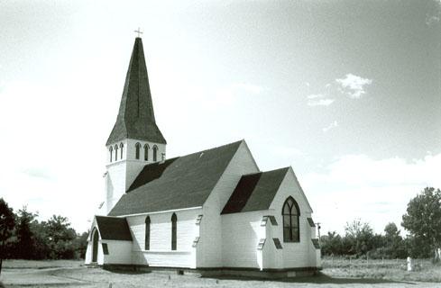
Christ Church Anglican National Historic Site of Canada
Maugerville, New Brunswick
Christ Church Anglican National Historic Site of Canada is a
mid-19th-century wooden church built in the Gothic Revival style. It is
located in the small rural community of Maugerville, New
Brunswick.
The heritage value of this site resides in the design, form and
materials of the church, which illustrate the Ecclesiological phase of
the Gothic Revival style of church architecture. This church was built
in 1856 to serve as an example of an ecclesiologically correct Gothic
Revival church realized in wood. Designed by diocesan architect Frank
Wills under the supervision of Bishop John Medley, a strong proponent of
the Ecclesiological movement, the church exemplifies the return to
medieval Gothic forms in church architecture. Wills' design successfully
interprets the volumes and angularity of the Gothic Revival style in
wood, a building material appropriate to the Canadian context. The
church reflects ecclesiological principles in its medieval-inspired
layout, the clear expression of interior components in exterior volumes,
the respect for the inherent qualities of its building material, and the
limited use of Gothic Revival style details. The simple, bold massing of
the church and its limited sculptural detailing also reflect the
adaptation of the Gothic Revival style to Canada's frost-prone climate
and limited pool of skilled labour.
|

©Parks Canada Agency / Agence Parcs Canada |
Christ Church Cathedral National Historic Site of Canada
Fredericton, New Brunswick
Christ Church Cathedral National Historic Site of Canada is a gracious
mid-nineteenth-century cathedral whose elegant spire rises above the
historic centre of Fredericton, New Brunswick. Dramatically sited on a
generous green near the Saint John River, the cathedral recalls its
English antecedents and has become an icon of Canadian ecclesiastical
architecture.
The heritage value of this site resides in its physical illustration of
the Gothic Revival style of architecture. Christ Church Cathedral is one
of the best examples of ecclesiological Gothic Revival architecture in
Canada and it established an architectural pattern followed in the
design of many large and small churches in 19th-century Canada. In its
architecture, logic and decoration, Christ Church Cathedral conforms to
the aims of the Ecclesiological Society, an Anglican reform movement
that actively sought a revival of medieval church models, both in ritual
and in architecture. Modelled after a 14th-century church in Norfolk,
England, the plans were drawn by the English architect, Frank Wills, at
the request of John Medley, the first Bishop of New Brunswick and member
of the Society. During the final stage of construction, the prominent
English architect, William Butterfield, modified the east end of the
cathedral by constructing a single tower in place of two. He also
designed much of the cathedral's original furniture and plate. The
cathedral's stone walls, crossing tower and picturesque massing echo the
building's interior, and were typical of the Gothic Revival style.
Following a fire in 1911, J. deLancey Robinson of New York completed a
restoration in 1911-1913 that included the lengthening of the spire and
the conversion of the former vestry into the present chapel.
|
©Parks Canada Agency / Agence Parcs Canada, 1987 |
Connell House National Historic Site of Canada
Woodstock, New Brunswick
Connell House National Historic Site of Canada is an imposing
two-and-a-half-storey wooden mansion distinguished by a double-height
columned verandah running along the front and one side of the main
block. This temple-fronted façade in the Greek Revival Style makes the
house one of the most outstanding early buildings in the historic town
of Woodstock, New Brunswick. The house is now a museum and archives
operated by the Carleton County Historical Society.
Lumber merchant and politician, Charles Connell had this house
constructed circa 1840. Houses inspired by classical temples, such as
Connell House, are rare in Canada, although they were more common in the
United States where Connell, who was of Loyalist descent, may have found
his inspiration. The temple format of the original block has been
obscured somewhat by several additions constructed in the late 19th and
early 20th centuries. The house remained a Connell family home until
1975 when it was purchased by the Carleton County Historical Association
for use as a museum and archives.
|
©Parks Canada Agency / Agence Parcs Canada, 1989 |
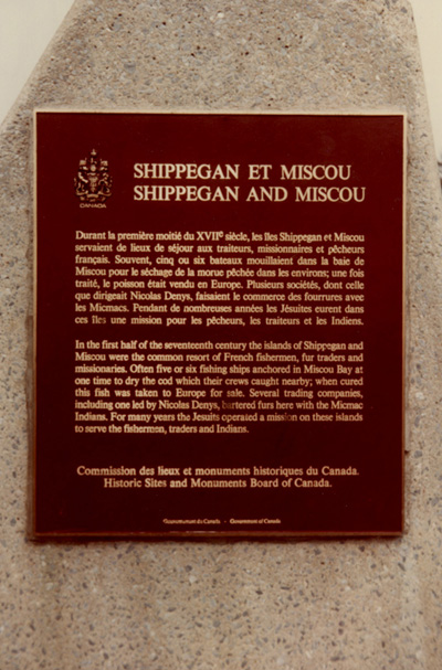
Denys Fort / Habitation National Historic Site of Canada
Shippagan, New Brunswick
In the first half of the seventeenth century the islands of Shippegan
and Miscou were the common resort of French fishermen, fur traders and
missionaries. Often five or six fishing ships anchored in Miscou Bay at
one time to dry the cod which their crews caught nearby; when cured this
fish was taken to Europe for sale. Several trading companies, including
one led by Nicolas Denys, bartered furs here with the Micmac Indians.
For many years the Jesuits operated a mission on these islands to serve
the fishermen, traders and Indians.
|


©Parks Canada Agency / Agence Parcs Canada |
Fort Beauséjour — Fort Cumberland National Historic Site of Canada
Aulac, New Brunswick
Remnants of 1750-51 French fort; captured by British and New England
troops in 1755.
Situated at the head of the Bay of Fundy on the border between New
Brunswick and Nova Scotia, Fort Beauséjour — Fort Cumberland stands
at a crossroads of natural and cultural history. The site is an
excellent venue to view a heritage landscape of great importance to
Canadian history.
Fort Beauséjour — Fort Cumberland National Historic Site was
founded in 1926 and recalls an era when European imperial forces
struggled for control of colonial lands in eastern North America.
Sweeping vistas of the surrounding marshlands can be seen from the site
and the winds that sweep the landscape whisper echoes of the area's
colourful historic past.
Fort Beauséjour — Fort Cumberland National Historic Site of Canada
is a star-shaped late 18th- and early 19th-century military
fortification situated on the narrow neck of land between Nova Scotia
and New Brunswick at the southwestern end of the Cumberland Ridge near
Aulac, New Brunswick.
The heritage value of Fort Beauséjour — Fort Cumberland National
Historic Site of Canada lies in its historical role as illustrated by
the extensive cultural landscape encompassing both the fortress and its
defensive works, as well as five outlying properties associated with it
(Butte à Roger, Ile de la Vallière, Chipoudy Point, the redoubt at Pont
à Buot, Inverma Farm). Construction of Fort Beauséjour was begun in 1751
by the French and completed by the British after they captured it in
1755 and renamed it Fort Cumberland. The fort closed in 1835. Parks
Canada now administers Fort Beauséjour as a national historic site of
Canada open to the public.
|

©Parks Canada Agency / Agence Parcs Canada Anne Bardou, 2006. |
Fort Charnisay National Historic Site of Canada
Saint John, New Brunswick
Fort Charnisay National Historic Site of Canada, of which there are no
visible remains, is located in Saint John, New Brunswick. Between 1645
and the early 19th century, the site hosted a succession of forts due to
its strategic position overlooking the St. John River on the western
edge of the city's harbour. The site is marked by a Historic Sites and
Monuments Board of Canada plaque and cairn, situated approximately 400
metres to the south of the designated place, on Market Place Street. The
footprint of the fort is located in the vicinity of what is today the
Harbour Bridge toll plaza, a site that served as an industrial area
related to the Saint John Harbour and railway during the early 20th
century.
A rivalry between Charles Menou d'Aulnay de Charnisay and Charles de la
Tour resulted in the construction of Fort Charnisay. Charles de la Tour,
who had constructed Fort Sainte Marie (also known as Fort La Tour) on
the east side of the Saint John Harbour in 1631, contested Charnisay's
1632 appointment as Lieutenant-Colonel to the King in Acadia. Charnisay
attacked and destroyed Fort Sainte Marie in 1645 and subsequently built
Fort Charnisay, a fortified trading post, on the west side of the
harbour.
Joseph Robinau de Villebon constructed the first military installation
on the site, Fort St. Jean, to protect Acadian settlers from the
British. His successor, Jacques-François de Monbeton de Brouillan,
dismantled the fort and moved to Port Royal in 1700 because he
considered its defensive position and drinking water sources inadequate.
The fort was rebuilt as Fort Menagoueche in 1749 when Lieutenant Charles
Deschamps de Boishébert et de Raffetot was ordered to secure the mouth
of the Saint John River and defend it against the British. Fort
Menagoueche was destroyed when Lieutenant de Boishébert burned it while
retreating from British Colonel Robert Monckton at the beginning of the
Seven Years War (1756-1763), leaving Louisbourg as the sole French
fortification in Acadia.
Monckton rebuilt the fort in 1758, naming it Fort Frederick. American
privateers destroyed this incarnation of the fort in 1775. The fort was
repaired a final time in response to the outbreak of the War of 1812.
The successive forts thus demonstrate the power struggles that took
place in this region during the 17th and 18th centuries.
For much of the first half of the 20th century, the site was part of an
industrial area serving the harbour and the railway, until it was
cleared in the mid-1960s for the construction of the Harbour Bridge toll
plaza, which opened in 1968.
|
©Parks Canada Agency / Agence Parcs Canada, 2003 |
Fort Howe National Historic Site of Canada
Saint John, New Brunswick
Fort Howe National Historic Site of Canada is located within parklands
in present day Saint John, New Brunswick. Marked by an Historic Sites
and Monuments Board of Canada plaque in the park's west end, the fort,
of which there are no extant remains, had been strategically located in
this area, at the top of an exposed limestone knoll overlooking the
Saint John River. The site has remained isolated from much of the urban
development that encircles the park.
The British constructed Fort Howe in 1777 as a response to several
requests from the residents around the mouth of the Saint John River
that their small settlement be protected from further attacks by
American privateers. With its location on a towering rock offering
unmatched views of the harbour and up the river, Fort Howe and its
garrison provided protection to the surrounding settlements through the
end of the War of 1812. The original fort consisted of a blockhouse and
barracks within a palisade on the western end of the hill, and a
blockhouse at the eastern end, and was manned by a detachment of the
Royal Fencible Americans under Major Gilfred Studholme. After the
founding of Parrtown, later renamed Saint John, in 1783, the fort served
as the military headquarters, as well as the first civil jail for the
new town. Following a fire in 1819 that destroyed the original barracks,
the fort fell into disrepair and by 1870 the remaining original
fortifications had been removed.
|

©Parks Canada Agency / Agence Parcs Canada |
Fort Gaspareaux National Historic Site of Canada
Port Elgin, New Brunswick
Military ruins and cemetery of 1751 French fort.
Fort Gaspareaux National Historic Site of Canada is an archaeological
site located just outside Port Elgin, New Brunswick, 4.8 km from the
village of Baie Verte. It is on a small point of land jutting into Baie
Verte on the Northumberland Strait separating the mainland from Prince
Edward Island. The site consists of 1.23 hectares of flat coastal land
on the south side of the estuary of the Gaspareaux River and is
protected by a substantial sea wall. Its landscape contains
archaeological traces of the French Fort Gaspareaux together with 9
graves of Provincial soldiers killed in 1756 while garrisoning the fort.
Fort Gaspareaux was designated a national historic site 1920 because of
its role in the struggle between France and Britain for North America in
the 1750s.
The heritage value of Fort Gaspareaux National Historic Site of Canada
resides in its associated history as illustrated by the site, setting
and associated remains. The strategic location and footprint of the
fort, its materials, construction technology and disposition all embody
value.
Fort Gaspareaux was a border outpost built by French troops in 1751 by
order of the Marquis de Jonquière, Governor-General of New France to
prevent the British from penetrating the Chignecto Isthmus. It also
served as a provisioning base for the forts of Acadia during the French
règime. The fort was manned by a skeleton staff of 19 soldiers led by M.
De Villeray when, on 17 June 1755, it was attacked by British soldiers
under Colonel John Winslow and forced to surrender. The British burned
the fortress in September 1756. Its location has been known since that
time even though the site of the fortress served as farmland for a long
period. This was one of the first sites to be commemorated by the
Historic Sites and Monuments Board of Canada and became the locus of
archaeological investigation in 1996.
|

©Parks Canada Agency / Agence Parcs Canada |
Fort Jemseg National Historic Site of Canada
Jemseg, New Brunswick
Built in 1659 by Thomas Temple during the English possession of Acadia,
as a trading post. Ceded to France in 1667. In 1674, captured by a Dutch
expedition under Capt. Jurriaen Aernouts, who named the country New
Holland, claiming possession for the Prince of Orange.
|

©Parks Canada Agency / Agence Parcs Canada |
Fort La Tour National Historic Site of Canada
Saint John, New Brunswick
Fort La Tour National Historic Site of Canada is an archaeological site
containing the remains of a 17th-century fortified fur-trading post in
Saint John, New Brunswick. It sits on a grassy knoll on Portland Point,
at the mouth of the Saint John River. Strategically located, the fort
enjoyed uninterrupted viewscapes up the river and across the Bay of
Fundy. Since the 19th century, the surrounding area has become
industrialized and is now characterized by a series of wharves and
structures lining the shore.
In 1631, Charles de Saint-Étienne de La Tour, Governor of Acadia and
fur-trading entrepreneur, established a fortified fur trading post named
Fort Sainte-Marie, at the mouth of the Saint John River. Located on
ground traditionally used by First Nations peoples, the fort became one
of the earliest centres of the French fur trade in the region.
Aboriginal traders carried furs down the Saint John River to trade at
the fort for goods such as beads, iron spear points and arrow heads. It
also provided a strategically located, fortified stronghold against La
Tour's rival, Charles de Menou d'Aulnay, whose base was at Port-Royal on
the opposite side of the Bay of Fundy. In 1645, d'Aulnay attacked the
fort during Sieur de La Tour's absence. Sieur de La Tour's wife,
Françoise-Marie Jacquelin, led a defence of the garrison for four days,
until finally surrendering to d'Aulnay. After taking possession of the
fort, d'Aulnay reneged on the conditions of surrender and executed the
members of the garrison. Jacquelin's bravery, and her death while in
d'Aulnay's custody, have made her a Canadian heroine. The fort itself
was destroyed at an unknown date in the 17th or early-18th
century.
|
©Parks Canada Agency / Agence Parcs Canada |
Fort Nashwaak (Naxoat) National Historic Site of Canada
Fredericton, New Brunswick
Fort Nashwaak (Naxoat) National Historic Site of Canada is marked by a
Historic Sites and Monuments Board of Canada plaque located in Carleton
Park, near the intersection of Union Street and Gibson Street in
Fredericton, New Brunswick. Although there are no extant remains or
known archaeological evidence of this fort, it was once a typical French
fort of the 17th century, with a palisade made of timber piles and
diamond shaped bastions. The fort had been constructed at the mouth of
the Nashwaak River where it flows into the Saint John River, about 700
metres south of where the plaque is found today.
Constructed by the Governor of New France, Joseph Robineau de Villebon,
during the winter of 1691-1692, Fort Nashwaak (Naxoat) served to
stabilize the New England-Acadia boundary, and prevented annexation of
the French colony by the English. From the fort, the French, with the
help of the Abenakis, organized and launched various raids against New
England settlements. During a summer 1696 raid, a French force under de
Villebon and his brother attacked and captured Fort William Henry.
Though the English retaliated by attacking Fort Nashwaak (Naxoat) by way
of the Saint John River, the seige failed and was lifted after two days.
In 1698, de Villebon was ordered by the King to build a new fort at the
mouth of the Saint John River and Fort Nashwaak (Naxoat) was demolished.
The site and any archaeological evidence has subsequently been washed
away due to erosion.
|

©Parks Canada Agency / Agence Parcs Canada, 2005 |
Fort Nerepis National Historic Site of Canada
Grand Bay-Westfield, New Brunswick
Fort Nerepis National Historic Site of Canada is strategically located
at Woodmans Point on the confluence of the Saint John and Nerepis Rivers
in New Brunswick. Originally a fortified Aboriginal village, a small
French fort was built at the original site circa 1749 by Charles
Deschamps de Boishébert. The remains of Fort Nerepis and its precise
location have never been found; however, the area on Woodmans Point is
marked by a cairn and plaque erected by the Historic Sites and Monuments
Board of Canada.
Nerepis was first known to have been the site of a fortified Aboriginal
village, strategically positioned to control entry into interior New
Brunswick along both the Saint John and Nerepis rivers. One of the
earliest documented references to Nerepis was in 1697, which noted that
the Sr. de Neuvillette would take scouts from Nerepis when he journeyed
along the river. Sometime after 1749, Lieutenant Charles Deschamps de
Boishébert et de Raffetot moved to this location to build a small fort,
and it is from him that the other names of the fort were derived. This
fort remained a French foothold until around 1755 when British forces
under Colonel Robert Monckton began the expulsion of Acadian French
settlers throughout the region.
|

©Parks Canada Agency / Agence Parcs Canada |
Fredericton City Hall National Historic Site of Canada
Fredericton, New Brunswick
Fredericton City Hall is a three-storey, red-brick building built in
1875-1876 in the Second Empire style. It is prominently located on a
corner lot in downtown Fredericton. The building is separated from the
street by a large, paved, public square, known as Phoenix Square, with a
fountain and paved walkways.
Built in 1875-1876, Fredericton City Hall follows the Second Empire
style, one frequently used for grand public buildings during the second
half of the 19th century. Its commanding presence and function as a
civic building are emphasized by the public square which fronts
it.
Like many 19th-century municipal buildings, Fredericton City Hall was
built to serve multiple civic functions. For more than 60 years, the
ground floor contained municipal offices and council chambers, the upper
storey contained an auditorium known as the Opera House, and the
basement contained a market. The inclusion of a market in a town hall
building was less common in the 1870s than earlier, as administrative
functions gained in importance and complexity. In 1940, the council
chambers moved to the upper storey auditorium and in 1951 the market
vacated the building. The building continues to be used as municipal
offices and council chambers.
|

©Parks Canada Agency / Agence Parcs Canada, 1989

©Parks Canada Agency / Agence Parcs Canada, 1989 |
Fredericton Military Compound National Historic Site of Canada
Fredericton, New Brunswick
Fredericton Military Compound National Historic Site of Canada is a
military complex of four early 19th century buildings located in the
Historic Garrison District of downtown Fredericton, New Brunswick. This
military compound sits next to the majestic St John's River. The complex
includes the Soldiers' Barracks, the Guard House, the Officers'
Quarters, and the Militia Arms Store. To the east of the Officers
Barracks is an open, green space known as Officers Square that is
approximately 70 by 90 metres. Additional buildings on the site were
built in the late 19th and 20th centuries.
The Fredericton Military Compound was established in 1784 as a British
military garrison and at one point included over fifty buildings. Many
of these buildings were destroyed in a fire in 1825 and extant military
buildings were constructed afterwards. The British garrison occupied the
Fredericton Military Compound until 1869 when the new Dominion of Canada
assumed responsibility for defence. Only four buildings remain from the
original British garrison: the Soldier's Barracks (1826), the Guard
House (1828), the Officer's Barracks (1839, 1851) and the Militia Arms
Store (1832). These buildings are representative of early 19th century
British military architecture.
|
©Parks Canada Agency / Agence Parcs Canada, 2008 |
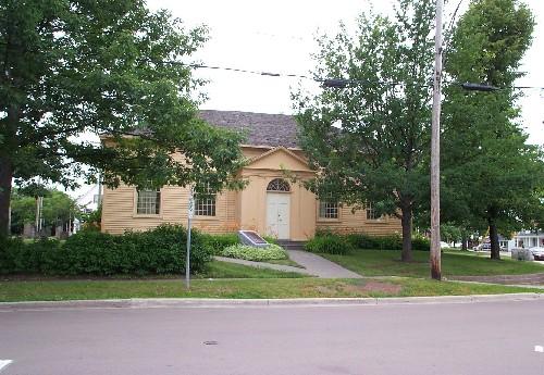
Free Meeting House National Historic Site of Canada
Moncton, New Brunswick
The Free Meeting House National Historic Site of Canada is a handsome,
wood frame building whose exterior design reflects British classical
influences, in its symmetrical elevation and classical details. The
interior reflects historic meeting house designs, being an open hall
with box pews. Located in downtown Moncton, the meeting house is now a
historic site accessible to the public.
The heritage value of this site resides in its historical associations
with religious toleration in the Maritime Provinces as illustrated by
the location and design of the building. Originally constructed in the
mode of a simple meeting house by members of the community, it was
dedicated as a house of worship in 1821. As the only local place of
worship, it was intended for use by all denominations and accommodated
numerous congregations including Protestant, Roman Catholic and Jewish,
until 1963. Over the years, the building was altered to respond to
changing usage and taste but was restored in 1990 as a Moncton
centennial project to approximate its 1821 condition. The Free Meeting
House has resumed its historical role as a venue for special services
held by various religious groups in the community.
|
©Parks Canada Agency / Agence Parcs Canada |
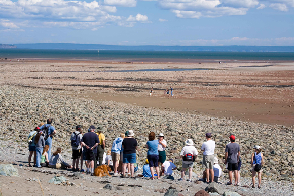
Fundy National Park of Canada
Headquarters: Alma, New Brunswick
Atlantic's sanctuary with world's highest tides.
Fundy National Park of Canada encompasses some of the last remaining
wilderness in southern New Brunswick. Here, the conifer dominated
Caledonia Highlands roll down to meet the fog-generating Bay of Fundy.
The tidal fluctuation of the Bay of Fundy is the highest in the world.
Watch fishing boats come and go to the rhythm of the bay. Inland,
explore lush forests and deep stream valleys.
|

©Parks Canada Agency / Agence Parcs Canada, Katherine Spencer-Ross, 1994 |
Greenock Church National Historic Site of Canada
St. Andrews, New Brunswick
Greenock Church National Historic Site of Canada is a handsome, wooden
Palladian-style church, distinguished by a classically inspired entry
porch and staged spire. Its double height interior with its high pulpit,
box pews and galleries, shows the influence of earlier meeting houses.
The church is set in the heart of a historic townsite, recognized as the
St. Andrews Historic District National Historic Site of Canada.
This elegant church marks the growth of both Presbyterianism and the
Kirk of Scotland in New Brunswick. Constructed in 1821-1824 by local
builder Donald D. Morrison, the structure successfully combines the
American meeting house form with the British Palladian style. The
building's fine proportions and classical details complement its simple,
symmetrical plan. The original box pews and two-tiered pulpit, birdseye
maple columns and decorative mouldings create a rich interior. The
carved green oak on the steeple symbolizes Greenock, the Scottish home
of the church's benefactor, Christopher Scott.
|

©Parks Canada Agency / Agence Parcs Canada |
Hammond House National Historic Site of Canada, 2008
Sackville, New Brunswick
Hammond House National Historic Site of Canada is a large, Queen Anne
Revival-style house located in a landscaped setting on the campus of
Mount Allison University.
Hammond House was designated a national historic site in 1990 because it
was a particularly good example of the Queen Anne Revival Style as
expressed in domestic architecture.
The heritage value of this site resides in its material expression of
the fanciful forms, asymmetrical massing and polychromatic surfaces
characteristic of the Queen Anne Revival, a style popular for residences
during the 1870-1914 period.
The house was designed by Burke and Horwood, architects, and built in
1896 for artist John Hammond. The Hammond family first resided there in
March 1897. Later it was taken over by Mount Allison University.
|
©Parks Canada Agency / Agence Parcs Canada 1987 |
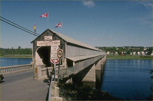
Hartland Covered Bridge National Historic Site of Canada
Hartland, New Brunswick
A striking feature in the New Brunswick landscape is the Hartland
Covered Bridge, the largest of its kind in the world. Its massive
concrete piers support a long, enclosed wooden bridge, held up by Howe
trusses. The bridge offers protected crossing of the Saint John River at
the Village of Hartland.
Hartland Covered Bridge was designated a national historic site of
Canada because this structure is the longest covered bridge extant in
the world.
The heritage value of this site resides in its design and physical
fabric. The structure, 390.75 metres long, is believed to be by far the
longest covered bridge extant in the world. Covered bridges date from
the first decade of the 19th century when North American buildings began
using wooden trusses for long spans and covered them to prevent the
truss joins from rotting. After 1840 the Howe truss, which introduced
iron tension rods into the truss work, was widely adopted and New
Brunswick erected numerous bridges using this technique, among them this
one, built in 1921 with a walkway added in 1943.
|
©Parks Canada Agency / Agence Parcs Canada |
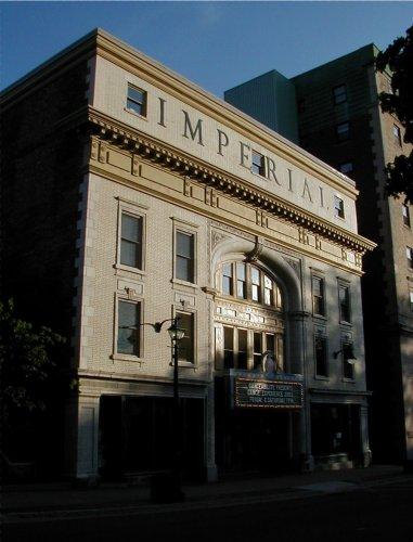
Imperial / Bi-Capitol Theatre National Historic Site of Canada, HRS 0543, 1993
Saint John, New Brunswick
Imperial / Bi-Capitol Theatre National Historic Site is an early 20th
century theatre building facing onto King's Square, Saint John.
The heritage value of the Imperial / Bi-Capitol Theatre lies in its
physical characteristics that speak to its role as a theatre designed
for live performance. Built in 1912-1923 by the Keith-Albee vaudeville
chain of New York and its subsidiary the Saint John Amusements Company
(A.E. Westover, architect), the Imperial Theatre opened as a combination
live and movie theatre in 1913. It was renamed the Capitol Theatre and
operated primarily as a cinema with occasional live entertainment,
1929-1957. During the mid 1980s it was restored as a live theatre and
re- named the Bi-Capitol Theatre.
|
©Parks Canada Agency / Agence Parcs Canada |
Kouchibouguac National Park of Canada
Headquarters: Kouchibouguac National Park, New Brunswick
Intricate Acadian blend of coastal and inland habitats.
Kouchibouguac is a fascinating mosaic of bogs, salt marshes, tidal
rivers, sparkling freshwater systems, sheltered lagoons, abandoned
fields and tall forests which characterizes the Maritime Plain Natural
Region.
|
|
La Coupe Dry Dock National Historic Site of Canada
Aulac, New Brunswick
Site may represent 18th-century Acadian construction.
This quadrilateral arrangement of dykes is believed to have been built
by the Acadians to regulate the flow of the river La Coupe, as to permit
the entrance and exit of vessels of moderate size.
|
©Parks Canada Agency / Agence Parcs Canada |
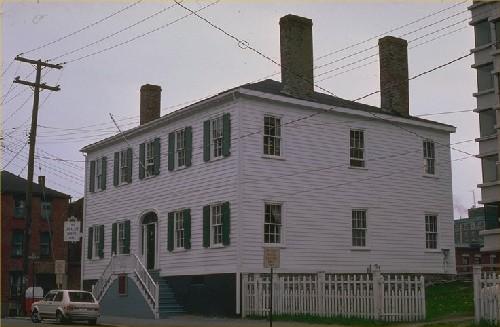
Loyalist House National Historic Site of Canada
Saint John, New Brunswick
A handsome reminder of the earliest days of settlement in Saint John,
the Loyalist House National Historic Site of Canada embodies the finest
qualities of early 19th-century classicism as it appeared in Atlantic
Canada. Its wooden construction in an overall classical design was
executed by specialized craftsmen using good quality domestic and
imported materials. Its fine interiors are now open to the
public.
Constructed before 1820 by the merchant David Merritt, this house was
maintained with minimal changes by five generations of his family who
lived there until 1959. Its harmonious proportions, symmetrical
composition and interior layout, and detailing show the influence of the
neoclassical design tradition brought from New England during this era,
referred to as "Federal". One of the oldest residences in the city,
Loyalist House is an important survivor of the Great Fire, which
destroyed much of central Saint John in 1877. The same family inhabited
the building for most of its existence and has survived remarkably
unchanged throughout the years.
|

©Parks Canada Agency / Agence Parcs Canada, 1991 |
Marine Hospital National Historic Site of Canada
Miramichi, New Brunswick
Marine Hospital National Historic Site of Canada is a one-storey,
sandstone building with a domed cupola, built in 1830-1831. It is
perched on high ground overlooking the Miramichi River. The former
hospital is surrounded by wood-frame residences in the small community
of Douglastown, now a suburb of the City of Miramichi, where it serves
as a church hall and community meeting place.
Built by Matthew Lamont for the Commissioners of the Port of Miramichi
in 1830-1831, the Marine Hospital at Douglastown is the oldest surviving
marine hospital in Canada. Until 1921, it provided care for indigent,
sick or disabled seamen, most of whom worked in the timber trade along
the Miramichi River. Its form, composition, roofline and cupola reflect
classical architectural traditions that were popular in early
19th-century British North America.
|

©Parks Canada Agency / Agence Parcs Canada, J. Butterill, 1995 |
Marysville Cotton Mill National Historic Site of Canada
Fredericton, New Brunswick
The Marysville Cotton Mill National Historic Site of Canada is the focal
point of the Marysville Historic District National Historic Site of
Canada. Rehabilitated to serve as government offices, the imposing,
four-storey, red-brick cotton mill building features a flat-roofed
central tower, and numerous multi-pane mullion windows. Located within
the former settlement of Marysville, a model community built to house
the mill workers, and the building is situated within the block bounded
by McGloin, Fisher, Duke, Marshall and Bridge Streets.
Industrialist Alexander "Boss" Gibson built this cotton mill between
1883 and 1885. Designed by the Boston architectural firm of Lockwood,
Greene and Company Mill Architects and Engineers, the construction of
the mill was influenced by New England models and is a classic example
of the brick "insurance mill" of the late 19th-century.
This four-storey building was constructed of locally made brick and
features brick pier construction, a central water tower and
fire-retardant materials on the interior. By 1900 Marysville Cotton Mill
was among the largest mills in Canada. The mill was designed on the
"slow-burning" principle and was state-of-the-art for its time,
incorporating not only electric lighting, but all those features
characteristic of plants whose power was provided from a central plant
and distributed by belts, pulleys and overhead shafting to machinery
whose location within the complex was dictated by its place within the
production framework. Despite its seemingly remote location, the mill
was designed to supply a national market and did so throughout its
working career. The mill continued manufacturing textiles until the late
1970s.
|
©Parks Canada Agency / Agence Parcs Canada |
Marysville Historic District National Historic Site of Canada
Fredericton, New Brunswick
Marysville is a former industrial (now residential) community, comprised
of a 19th-century rehabilitated cotton mill, former shops and extensive
surviving housing. It is located on the banks of the Nashwaak River on
the outskirts of the city of Fredericton. The buildings are arranged
around the former mill, with the former commercial area nearby.
Primarily brick row and semi-detached housing is concentrated along the
east side of the river. The principal resources include: the
rehabilitated late 19th-century brick cotton mill; brick tenement
housing nearby (39 duplexes, 14 single houses and a fire-damaged former
boarding house); 11 frame duplexes along the east riverbank; two former
shopkeepers houses and a former shop on Mill and Canada streets; and 19
residential properties (formerly for managers) along Canada Street.
The Marysville Historic District was designated a national historic site
as a rare example of a single-industry company town of the 19th century
possessing both its plant and company housing; as a historic district
containing a full range of community facilities, including industrial,
commercial and residential buildings, erected between c1840 and 1890;
and because it largely retains its 19th-century appearance and
character. The area is also associated with, and illustrates two
important historical themes — the staples trade and the industrial
development of Canada under the National Policy. The former Marysville
Cotton Mill also has an individual designation as a national historic
site.
Marysville originated as a logging community, with a lumber mill on the
west bank of Nashwaak River and a row of workers' housing along the
opposite bank. The "White Row" duplexes on River Street reflect this
c1840s era.
In 1862, Alexander "Boss" Gibson purchased the mill property, naming it
Marysville and adding manufacturing facilities, housing and a commercial
area. A wood-frame store and nine houses in the Nob Hill area reflect
the Gibson lumber mill era. Their design and materials are typical of
those used for mid-19th-century, working-class residences in New
Brunswick. Seven duplexes represent original buildings from the
mid-nineteenth century. Five duplexes were rebuilt in 1920 to replace
buildings destroyed by a 1920 sawmill fire. The arrangement of duplexes
in a row along the riverbank reflects their mid-19th-century
configuration.
Marysville reflects the Macdonald administration's use of the National
Policy to create an industrial economy in Canada. In 1883, encouraged by
the introduction of protective tariffs under the National Policy, Gibson
hired Boston architects Lockwood, Greene & Company to design a
state-of-the-art cotton mill at Marysville. Lockwood, Greene & Company
also designed a planned community around the mill, with brick tenement
housing for workers, additional managers' housing, and an enlarged
commercial area. Surviving brick workers', managers' and merchants'
housing, together with the mill, reflect the cotton mill era at
Marysville.
The planned community at Marysville is among the earliest and most
complete Canadian examples of an integrated industrial/ residential
community. It reflects the paternal model of 19th-century labour
relations, in which industrialists sought to control the working and
living conditions of workers, with a view to optimizing production. The
high quality, brick construction of both tenements and mill reflect
Gibson's optimism for the community. The Mill Street commercial area
reflects the paternal model of industrialism practised by Gibson, in
which company shops were provided for mill employees within the
integrated setting of the industrial/residential community. Surviving
buildings represent the commercial needs of a 19th-century community,
and include residences provided for merchants.
|

©Parks Canada Agency / Agence Parcs Canada, 1987 |
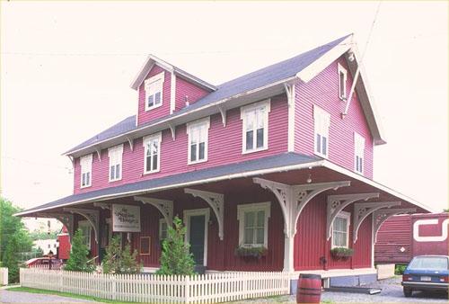
McAdam Railway Station (Canadian Pacific) National Historic Site of Canada
McAdam, New Brunswick
The McAdam Railway Station is a large, two-and-a-half-storey, stone,
Chateau-style railway station and hotel building. Built in 1900-01 and
enlarged in 1910-11, it dominates its immediate surroundings in the
small town of McAdam, New Brunswick.
The McAdam Railway Station was designated a national historic site in
1976 because of its association with the development of the Canadian
Pacific Railway (CPR) and because it is a rare surviving example of both
a station in the Chateau Style and one which combined a station with a
hotel.
Built at the turn of the century, the McAdam station illustrates the
beginning of a period of tremendous growth and expansion for the CPR. It
is one of the largest, surviving examples of the Chateau style from the
CPR inventory. Built to replace an earlier station, it reflects McAdam's
prosperity and importance as a railway junction and the expectation that
this would continue. The McAdam station is a rare surviving example of a
combined railway station and hotel. While its layout is typical of
stations of its size in terms of functional arrangements and features,
it is distinguished by the incorporation of hotel facilities. No longer
functioning as an active station, the building now is maintained by the
McAdam Historical Restoration Commission Inc.
|

©Parks Canada Agency / Agence Parcs Canada, 2008 |
Mehtawtik (Meductic) Village National Historic Site of Canada
Meductic, New Brunswick
Mehtawtik (Meductic) Village National Historic Site of Canada
is located near the confluence of the Eel River and Saint John River, in
New Brunswick. The site, dating from before the 17th century, was
originally situated on a plateau west of the Saint John River; but in
1968 the Mactaquac Hydroelectric Dam was built, flooding much of the
Saint John River valley, including the entire site of Meductic. A
Historic Sites and Monuments Board of Canada plaque and cairn marking
the site is located nearby on Fort Meductic Road.
The fortified village of Meductic was established by the Maliseet First
Nation on a plateau on the bank of the Saint John River, west of the Eel
River. Each spring, the lowlands around the plateau filled with water
creating arable land for crops. Until the 17th century, the nomadic
Maliseet would regularly visit the site in the spring to plant corn,
returning later in the year to harvest their crops. In their battle for
this valuable territory, the French settlers in the region allied
themselves with the Iroquois, Maliseet and Penobscot, while the English
allied themselves with the Mohawk. To defend themselves against the
Mohawk and to protect their claim to this geographically significant
settlement, the Maliseet established a fort on the plateau.
By the end of the 17th century, Meductic had a Jesuit mission and was
incorporated into a French seigneury. The mission changed the landscape
of Meductic, and by 1760 the Maliseet, who left to settle in other
communities, abandoned the village. The land was then sporadically used
as an Aboriginal camp until 1841. Shortly thereafter, the site became
part of a farm that was owned by the Hay family throughout the late 19th
century. In 1968 the Mactaquac dam was built, flooding much of the Saint
John River valley, including the entire site of Meductic.
|

©Parks Canada Agency / Agence Parcs Canada, L. Maitland, 1995 |
Minister's Island National Historic Site of Canada
St. Andrews, New Brunswick
Minister's Island National Historic Site of Canada is a well-preserved,
picturesque summer estate and gentleman's farm, developed in the late
19th and early 20th century. It comprises all of a 280-hectare island in
Passamaquoddy Bay, on the eastern coast of New Brunswick. At low tide
the island is connected to the mainland by a land bridge. The estate
consists of a complex of buildings designed in an elegant, but relaxed,
version of the Shingle style, surrounded by forests and fields. The
landscape comprises four interconnected zones: the main house with its
ancillary buildings, lawns and gardens; the agricultural lands and
buildings to the north; the recreational lands comprising the beaches,
tennis court, croquet lawn, paths and carriage roads; and the forest
covering a third of the island. The main house is supported by ancillary
buildings including a garage, a carriage house, a windmill, a gas plant,
and a bathhouse. Agricultural buildings include a barn, a dairy, a
bunkhouse, a gardener's cottage with the remnants of a vinery attached,
and a late 18th-century, stone farmhouse.
The estate speaks eloquently about the life and times of the builder of
the Canadian Pacific Railway, Sir William Cornelius Van Horne. In
developing the property, Van Horne was actively assisted by his wife,
Lucy Adeline Hurd Van Horne, and their daughter Adeline, who continued
to develop the estate after Van Horne's death. The estate is directly
associated with Van Horne's business life and reflects his wide-ranging
interests.
Architect Edward Maxwell of Montréal, one of Canada's best-known
residential and commercial architects, designed the estate's residential
and farm complexes. The structures represent fine examples of Shingle
style buildings and turn-of-the-century aesthetic ideas about the need
for harmonious relationships between buildings and landscapes.
In its comfortable blending of ocean horizons, beaches, farm, fields,
forests and buildings faced in stone and wood, the estate is a personal
and regional response to country estate traditions drawn from British
and American models. The estate influenced the development of other
resort communities, most notably, St. Andrew's, New Brunswick.
|
©Parks Canada Agency / Agence Parcs Canada, 1939 |
Minister's Island Pre-contact Sites National Historic Site of Canada
St. Andrews, New Brunswick
Minister's Island Pre-contact Sites National Historic Site of Canada is
composed of below-ground archaeological sites located on Passamaquoddy
Bay in the southwest corner of New Brunswick. The remains associated
with these sites date from 1000 to 500 BCE. The so-called island is
connected to the mainland by a natural bar, covered at high tide and
exposed at low tide. Comprising some 280 hectares (700 acres), the
island was developed by railway baron William Van Horne as a summer
estate called Covenhoven, now open to the public as Minister's Island
National Historic Site of Canada. This group of archaeological sites is
marked by a commemorative plaque.
Located on the former grounds of William Van Horne's summer estate on
Minister's Island, now Minister's Island National Historic Site of
Canada, near the town of St. Andrews, this group of archaeological sites
contains the remains of four houses dating back at least 1200 years as
well as the mounds of shells left from generations of shellfish
harvesting, all indicating that this was probably a coastal winter
settlement.
|
©Parks Canada Agency / Agence Parcs Canada, Ministry of Transport, 1990 |
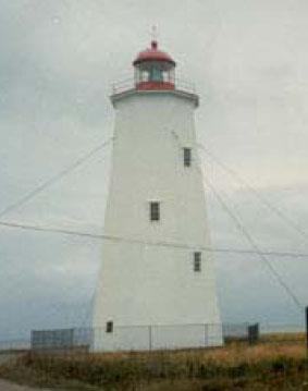
Miscou Island Lighthouse National Historic Site of Canada
Miscou Island, New Brunswick
Miscou Island Lighthouse National Historic Site of Canada is a mid-19th
century wooden lighthouse, located at the north-eastern tip of Miscou
Island at Birch Point Cape, New Brunswick. It is strategically placed on
a flat and exposed coastline surrounded by low scrubland, at the
southern entrance of Chaleur Bay in the Gulf of St. Lawrence. The
tower's tapered octagonal massing is shingle-clad, and capped by a
polygonal lantern behind a cast-iron rail. A mid 20th-century foghorn
building stands on its side.
The heritage value of Miscou Island Lighthouse lies in its critical and
longstanding role as a lighthouse as embodied by the tower's function,
setting, and composition. In 1856, the lighthouse was constructed by the
Province of New Brunswick to reduce the number of shipping accidents in
the region. Subsequently, it became a major coastal aid, providing safe
navigation for ships entering the Chaleur Bay and for coastal traffic
between the Atlantic Provinces and Quebec.
The Miscou Island Lighthouse is one of the rarest surviving wooden,
octagonal, tapered lighthouses. The construction technique was unusual
as the eight panels were built independently of each other. The
lighthouse's functional design was enhanced with the installation of a
powerful dioptric light and a diaphone fog alarm. In 1903, its height
was raised from 22.5 to 24.3 metres in order to extend the range of
light. In 1946, the entire lighthouse was relocated 61 metres inland due
to shoreline erosion. Today, the light is automated and still
operating.
|
©Parks Canada Agency / Agence Parcs Canada
©Parks Canada Agency / Agence Parcs Canada |
Monument-Lefebvre National Historic Site of Canada
Memramcook, New Brunswick
Multi-function building, symbol of Acadian cultural revival.
The Monument-Lefebvre National Historic Site of Canada is situated in
the Memramcook Valley of southeastern New Brunswick. The
Monument-Lefebvre building is the symbol of the renaissance of
contempory Acadie. It stands as a tangible monument which allows all to
appreciate the history, the culture and the accomplishments of the
Acadian people. Housed in this heritage building is the new Exhibit
"Reflections of a Journey - the Odyssey of the Acadian People". The
Exhibit serves as a cultural interpretive centre where visitors can
immerse themselves in all things Acadian.
Monument-Lefebvre National Historic Site of Canada is an imposing stone
structure situated on an elevated site on the campus of Saint-Joseph's
College in Memramcook, New Brunswick. The building is constructed of
rusticated New Brunswick olive sandstone and its symmetrical,
classically designed façade features Romanesque Revival details. The
structure houses a theatre and classrooms, facilities that contributed
to the goal of sustaining and nourishing Acadian culture and education.
Official recognition refers to the building on its footprint.
The Monument-Lefebvre was built in memory of Father Camille Lefebvre,
who died in 1895. Work commenced in 1896, and the building was
officially opened in 1897. Father Lefebvre founded the College
Saint-Joseph at Memramcook as the first French language institution to
confer university degrees in the Atlantic region, and played a prominent
role in the rebirth of Acadian culture in Canada in the late 19th
century. Closed in the 1970s, the building was preserved as a memorial
to Acadian culture and Father Lefebvre's work. Its heritage value lies
in its association with Father Lefebvre as illustrated by its use and
physical characteristics.
|

©Harold E. Wright, Heritage Resources / Ressources patrimoniales, Saint John, 2009 |
Number 2 Mechanics' Volunteer Company Engine House National Historic Site of Canada
Saint John, New Brunswick
Number 2 Mechanics' Volunteer Company Engine House National Historic
Site of Canada is a handsome stone fire hall facing King's Square, the
oldest public park in the heart of Saint John, New Brunswick. Sandwiched
between the larger court house and a row of four-storey commercial
buildings, the small, two-storey, pitched-roof building speaks to its
time and function.
The frequency and severity of citywide fires so terrified Canadians in
the early-19th century that communities began to construct permanent
fire stations. Erected in 1840, this elegant neo-classical building is a
pioneer example of a fire hall designed to house volunteer brigade using
manually drawn and operated pumper fire engines. The work of local
architect John Cunningham, this building recalls the earliest phase in
the development of municipal fire fighting in Canada when volunteer fire
brigades served as the best line of defence against devastating fires
and played an important role in Victorian urban life. It operated as a
fire hall until 1948 and is now open to the public as a museum of fire
fighting.
|
©Parks Canada Agency / Agence Parcs Canada, 1990 |
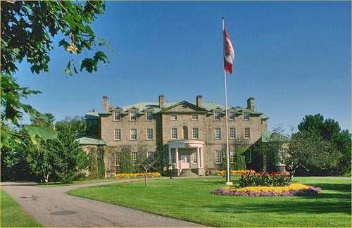
Old Government House National Historic Site of Canada
Fredericton, New Brunswick
Old Government House National Historic Site of Canada is a large, stone,
Palladian-style residence of New Brunswick's lieutenant governor. It is
located on a 4.5 hectare (11-acre) site on Woodstock Rd., just west of
the centre of Fredericton, on the banks of the Saint John River.
Old Government House National Historic Site was designed by English
artist and designer J.W. Woolford and was built in 1826-1828 to house
the Governor of the Colony of New Brunswick. It replaced an earlier
governor's residence (1787), which had been destroyed by fire. An
historic encounter between Governor Arthur Gordon and Premier Albert J.
Smith occurred here on 7 April 1866, paving the way for Confederation.
This building served as the official residence of the governors, then
lieutenant governors of New Brunswick until 1893 when a new official
residence was constructed. It then became a veterans' hospital, and
subsequently headquarters of J Division of the RCMP from 1932 to 1988.
Since then, it has been restored and has resumed its original function
as the residence of the Lieutenant Governor.
The heritage value of Old Government House National Historic Site
resides in its functional role as an official residence (both 1828-1893
and 1988-present), its experience as the site of an important event in
Canadian history, and in its Palladian-style architecture. Value also
lies in its site and setting.
|

©Parks Canada Agency / Agence Parcs Canada |
Ordnance Building National Historic Site of Canada
Saint John, New Brunswick
The Ordnance Building was built in 1842 and is a rare example of a military
ordnance building of the colonial period, implementing the recommendations of
the Royal Commission of 1825 which set out a broad defensive strategy for the
colonies that was supported by the Commander-in-Chief of the British Army, the
Duke of Wellington; it was enlarged in 1911 with the construction of the mansard
roof reflecting a period in which Canada expanded its military infrastructure;
it exemplifies the ordnance building type in its utilitarian classicism, sturdy
construction and flexibility and is noteworthy for the combination of military
construction from both the colonial and Dominion periods; it is one of the few
buildings in Saint John to have survived the Great Fire of 1877.
|

©Moncton Museum |
Our Lady of the Assumption Cathedral National Historic Site of Canada
Moncton, New Brunswick
Designed and built in 1939-1940, Our Lady of the Assumption Cathedral speaks
to the history of the Acadian people. Decorative elements related to their
religious and secular history are found throughout the cathedral; these
include an exterior sculpture of the Virgin Mary, patron saint of the
Acadians, and stained glass windows depicting significant religious and
historical events. Its exterior architecture is an accomplished and eclectic
blend of Gothic Revival and Art Deco styles, while the interior draws from
the Romanesque style. Built to affirm the Acadian identity and pay tribute to
their resilience, its construction mobilized the Acadian community and
diaspora behind a project to erect the first large-scale building
commemorating them as a distinct people. The cathedral is associated with the
establishment of the Archdiocese of Moncton in 1937 and embodies the final
phase of the Acadian Renaissance. This place of worship continues to be a
tangible symbol of the achievements of Acadians throughout their history.
Built according to plans drafted by the architect Louis Napoléon Audet
(1881-1971), the cathedral measures about 70 metres long by 43 metres wide.
In addition to the church, the building includes two chapels, two sacristies,
and many rooms located on multiple floors. Many of its decorative elements
refer to the Acadian people and their history. Inside the church, the crowns
(capitals) on the pillars facing the main altar were carved by Acadian
craftspeople and depict objects associated with various trades practised by
the Acadians throughout their history. The two large stained-glass windows in
the cathedral transepts depict significant events in the religious and
secular history of Acadia and its people.
Our Lady of the Assumption Cathedral is the physical manifestation of the
culmination of decades of efforts by Acadians to win recognition for their
presence, their demographic importance, and their legitimate rights as full
citizens in the political, social, economic, cultural, and religious contexts
of the Maritime provinces. The construction project was supported by Acadians
in the archdiocese, the Maritime provinces, Quebec, Louisiana, and New
England.
The cathedral stands on the former site of a crypt and unfinished chapel that
was used as a place of worship in the first French-speaking parish in
Moncton, which was itself born out of the breaking up of St. Bernard's Parish
in 1914. The cathedral is the achievement of this parish's first archbishop,
Mgr. Louis-Joseph-Arthur Melanson (1879-1941). Acadians in New Brunswick and
the Maritime provinces consider it to be a crown jewel of their architectural
heritage, and its historical and heritage value stems in large part from the
associative and symbolic values conferred on it by the Acadian
community.
|
©Parks Canada Agency / Agence Parcs Canada, ca. 1982 |
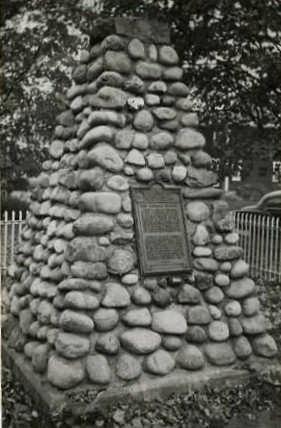
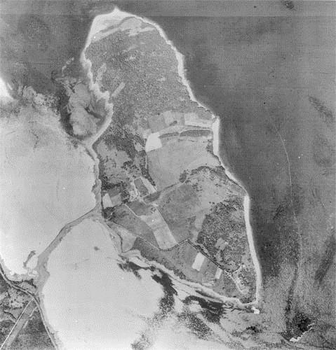
Oxbow National Historic Site of Canada
Red Bank Indian Reserve (Metepenagiag Mi'kmaq Nation), New Brunswick
Oxbow National Historic Site of Canada is an archaeological site located
within the reserve land of the Metepenagiag Mi'kmaq Nation, New
Brunswick across the Little Southwest Miramichi River from the present
Mi'kmaq community. The site is an oxbow bend of the river and follows
the north bank of the river, encompassing the place where stratified
archaeological resources are buried in the silts and gravels of the
river bank to a depth of up to two metres. It is situated within the
Metepenagiag Heritage Park, as the Augustine Mound National Historic
Site of Canada.
Oxbow was designated a national historic site of Canada in 1982 because
it is a unique cultural record of a flourishing Mi'kmaq community which
has endured for at least 3000 years and it shows a direct relationship
between the everyday life of the community and its spiritual centre at
the Augustine Mound.
The heritage value of Oxbow National Historic Site of Canada lies in its
role as witness and record of 3000 years of continuous Mi'kmaq use of
this site as illustrated by its setting, site, dense composition, by the
spatial, functional and cultural inter-relationships of its layered
components, and by the rich and varied nature of the archaeological
evidence they contain. Value also lies in the direct association of
early levels of the site with the Augustine Mound, designated national
historic site of Canada in 1975.
Oxbow National Historic Site of Canada contains evidence of 3,000 years
of Mi'kmaq history (from 1000 BC to the present) on the north bank of
the Little southwest Miramichi River at the head of tide. Annual
flooding of the river bank has created a well-stratified site in which
the cultural development through time is preserved in multiple layers of
sediment. This deep stratigraphic development is virtually unique in
Maritime Canada. Most of the archeological remains constitute a
collection held in the archaeological services office of the New
Brunswick Government in Fredericton.
|
©Parks Canada Agency / Agence Parcs Canada, Cameron |
Partridge Island Quarantine Station National Historic Site of Canada
Saint John, New Brunswick
Partridge Island Quarantine Station National Historic Site of Canada
comprises Partridge Island at the entrance to Saint John harbour,
approximately 1 kilometre from the shore of west Saint John, New
Brunswick.
The heritage value of Partridge Island Quarantine Station National
Historic Site of Canada lies in its historic role as a 19th-century
quarantine station as illustrated by the site, setting and landscape of
the island and the quarantine-related remains it contains. Partridge
Island was one of two major quarantine stations in 19th-century Canada.
Established in 1830 to protect Canadian citizens from contagious
diseases carried by in-coming ships, the station provided treatment for
immigrants and crewmembers who were ill, as well as purification
facilities for the healthy passengers aboard the ships. This station was
active during a particularly early and busy period of Canadian
immigration. During 1847, 2000 Irish immigrants fleeing from the potato
famine were quarantined here during a typhus epidemic. 601 of them are
buried in a mass grave on the island. Passengers quarantined on this
island eventually settled in New Brunswick, Upper Canada and the United
States.
Partridge Island continued to be used as a quarantine station until
1941. It was occupied for the military defence of Saint John during both
World Wars, and also used as a light station. All buildings on the
island were demolished in 1955 and 1998-1999. Today the site contains
remnants of buildings and structures associated with its important role
as a 19th-century quarantine station, including those of the doctor's
residence (built ca. 1872), the 2nd class immigrants, marine officers'
and smallpox hospitals (1899-1901), a low water wharf, and a cemetery
containing graves from the 1847 typhus epidemic.
|

©Parks Canada Agency / Agence Parcs Canada, 1992 |
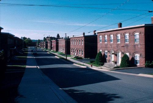
Prince William Streetscape National Historic Site of Canada
Saint John, New Brunswick
This streetscape comprises twelve public and commercial buildings in
downtown Saint John, New Brunswick. These distinguished late
19th-century, masonry buildings are concentrated in a two-block stretch
of Prince William Street in the vicinity of Princess and Duke
streets.
The heritage value of the Prince William Streetscape resides in the
concentration of architecturally notable public and commercial buildings
within a two-block area. Most were erected after the Great Fire of 1877,
and their use of late 19th-century architectural styles, fire-retardant
materials and fine craftsmanship illustrates the determination of the
city of Saint John to rebuild its fortunes in the wake of the disastrous
fire.
|
©Parks Canada Agency / Agence Parcs Canada, 1993 |
Rothesay Railway Station (European and North American) National Historic Site of Canada
Rothesay, New Brunswick
The Rothesay Railway Station (European and North American) is a
two-and-a-half-storey, Neo-Gothic, railway station with stationmaster's
quarters above. It was built in the mid-19th century and is centrally
located in the community of Rothesay.
Rothesay Railway Station (European and North American) was designated a
national historic site in 1976 because it commemorates the development
of the Maritime Railways and it is a good surviving example of a number
two standard station designed by the European and North American Railway
(ENAR).
Rothesay Railway Station (European and North American) was one of the
first stations built by the newly formed ENAR along its Saint John to
Shediac line. Built to a standard design, the Rothesay station is one of
a small number of surviving ENAR stations built before 1860 that
represent the earliest surviving examples of railway architecture in the
Maritime provinces.
|
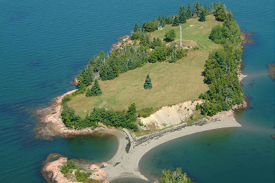
©Parks Canada Agency / Agence Parcs Canada |
Saint Croix Island International Historic Site
New Brunswick
Saint Croix Island is the site of Pierre Dugua's first attempt at
settlement in North America, which led to the establishment of the
permanent colonies of Acadie and New France.
Welcome to Saint Croix Island, site of Pierre Dugua's first attempt at
settlement in North America, which led to the establishment of the
permanent colonies of Acadie and New France. The site was declared a
National Monument by the United States National Park Service on June 8,
1949 and an International Historic Site on September 25, 1984. In 1958,
the Historic Sites and Monuments Board of Canada recommended that Saint
Croix Island be recognized for its national historic significance to
Canada. The Canadian interpretation site, administered by Parks Canada,
is located at Bayside, New Brunswick, near St. Andrews. It overlooks
Saint Croix Island, located in the middle of the Saint Croix
River.
In 1603, Pierre Dugua, Sieur de Mons, was given the title of Lieutenant
General of "La Cadie" (Acadie). The following year, he arrived in Acadie
on the flagship Bonne-Renommée . The ship's company included Samuel de
Champlain, a skilled mapmaker and chronicler. In search of a suitable
site for settlement, the expedition arrived in the Passamaquoddy Bay in
late June. De Mons named the island Saint Croix and it was there that he
tried to establish year-round French settlement in North America, an
event that symbolizes the founding of Acadie.
Even though the settlement was short-lived, in the summer of 1605 they
moved to the shores of the present-day Annapolis Basin in Nova Scotia
where Port Royal was established, their experience taught them much. The
invaluable experience they gained from this first settlement gave them
the knowledge they needed to found a more successful settlement at Port
Royal and gave way to an enduring French presence in North America to
this present day.
|
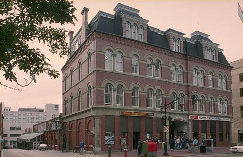
©Parks Canada Agency / Agence Parcs Canada, 1987 |
Saint John City Market National Historic Site of Canada
Saint John, New Brunswick
The Saint John City Market National Historic Site of Canada is a large,
brick building located across from the northwestern corner of King
Square in the central business district of Saint John, New Brunswick.
The building extends the length of a city block. Completed in 1876, its
formal entry façade, a three-and-a-half storey Second Empire-Style
office block, faces the square. Extending back from this block is the
market hall with its double height open space organized around a wide
central aisle and individual stalls that extend along both sides. The
market space is distinguished by exposed timber framing and queen post
trusses supported by cast iron columns.
The Saint John City Market illustrates the development of buildings
designed specifically as markets in 19th century Canada. The solid,
fire-resistant Saint John Market building was constructed between
1874-1876 to the designs of New Brunswick architects McKean and
Fairweather. It survived the Great Fire of 1877 and was renovated over
the years, allowing it to remain an important civic structure that
continues to fulfill its original function.
|
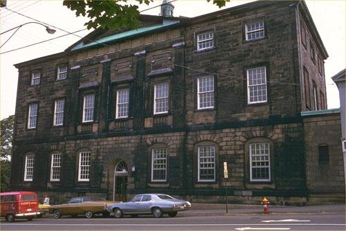
©Parks Canada Agency / Agence Parcs Canada, 1980 |
Saint John County Court House National Historic Site of Canada
Saint John, New Brunswick
Saint John County Court House is a three-storey, stone building built
from 1826 to 1829 in the Neoclassical style. It is located in the city
of Saint John, New Brunswick, in an urban area of 19th-century
buildings. The Court House is set on high ground on a corner lot, with
the gaol behind. Across the street are the Loyalist Burial Grounds and a
treed, city square known as King Square.
Saint John County Court House was designated a national historic site in
1974 because it is representative of the judicial institution in New
Brunswick; and, with its conscious arrangement of classical details, the
building creates an impression of order and grandeur.
The Saint John County Court House was built in 1826-9 to provide
courtrooms and office space for the Supreme Court and the Court of
Quarter Sessions. It also contained a Council Chamber for sittings of
City Council. Today, it contains the Office of the Sheriff/Coroner and
is used for sessions of the Court of Queen's Bench and Provincial Court
as needed.
In its materials, form, composition and detailing, the Court House is
typical of early-19th-century, British, public buildings in Canada. Its
Neoclassical style imparts an air of sobriety and sophistication
appropriate to its role as a court house. The Court House is
distinguished by its free-standing, circular, interior staircase, with
cantilevered stone steps rising three storeys in height without other
means of support. Originally designed by local architect John
Cunningham, the Court House was renovated in 1924 under the supervision
of architect Garnet Wilson, following a devastating 1919 fire.
|

©Parks Canada Agency / Agence Parcs Canada, HRS 1075, 1996 |
Seal Cove Smoked Herring Stands National Historic Site of Canada
Grand Manan Island, New Brunswick
The Seal Cove Smoked Herring Stands NHSC on Grand Manan Island consists
of some 54 vernacular wooden buildings, most built between 1870 and
1930, and their associated landscape sited around a cove bounded by
breakwaters at its mouth and a creek at its head. These stands are
situated between the Atlantic ocean and the village and hills to their
rear.
The heritage value of the site resides in the meeting of built and
natural features in an aesthetic whole typical of vernacular maritime
landscapes of the late 19th century.
|

©Parks Canada Agency / Agence Parcs Canada, 1987 |
St. Andrews Blockhouse National Historic Site of Canada
Saint Andrews, New Brunswick
Restored wooden blockhouse from War of 1812.
St. Andrews Blockhouse National Historic Site is situated in the
picturesque seaside resort of St. Andrews, in southwestern New
Brunswick. Here you will step back in time to an era of conflict along
New Brunswick's border with the United States. Imagine a time when these
neighbours were at war. Fearful of American invasion, townspeople built
this blockhouse, to military specifications, during the War of
1812.
St. Andrews Blockhouse is a wooden defensive structure located on the
west point of the harbour at the extreme edge of the historic town of
St. Andrews, New Brunswick.
The heritage value of St. Andrews Blockhouse lies in its illustration of
a specific type of defensive structure, and in its origins during the
War of 1812. It was built in 1812-13 by the citizens of St. Andrews to
safeguard against American raiders. During the late 19th century, it
became a picturesque tourist attraction in the resort town of St.
Andrews, then was acquired and restored by National Historic Sites
(1962-1967). The blockhouse was seriously damaged by fire in 1993, and
once again restored to its early appearance.
|

©Provincial Archives of New Brunswick /Archives provinciales du Nouveau-Brunswick, P11-189, ca. 1914 |
St. Andrews Historic Distric National Historic Site of Canada
St Andrews, New Brunswick
The St. Andrews Historic District comprises the original part of the
present town of St. Andrews, New Brunswick. It is laid out as a grid of
sixty blocks running back from the shoreline and has been built, over
the years, with variations of classically inspired architecture.
Commercial buildings are concentrated on the street running parallel to
the harbour. The relatively spacious lots and the largely unbuilt
commons surrounding the district provide a balance of greenery to this
built landscape.
|

©Parks Canada Agency / Agence Parcs Canada, 1995 |
St. Anne's Chapel of Ease National Historic Site of Canada
Fredericton, New Brunswick
St. Anne's Chapel of Ease is a small, elegant, stone church built in
1846-7 in the Ecclesiological Gothic Revival style. It is centrally
located within the city of Fredericton, New Brunswick, in a historic
residential neighbourhood.
St. Anne's Chapel of Ease was designated a national historic site in
1989 because it is a significant example of Gothic Revival religious
architecture based on the principles of the Ecclesiological
Society.
St. Anne's Chapel of Ease reflects the early adoption of the principles
of the Ecclesiological Society, an Anglican organization of English
origin that promoted the use of medieval Gothic style church
architecture as a model for parish churches of the 19th century. The
Bishop of New Brunswick, John Medley, actively promoted the style in the
design and construction of churches in Atlantic Canada beginning with
his appointment as Bishop 1845. St. Anne's Chapel of Ease, constructed
at the same time as Fredericton's Christ Church Cathedral, served as a
model for the principles Medley espoused. The fine stained glass lancet
windows were created by two firms: Beers of Exeter and Warrington of
London.
|

©Parks Canada Agency / Agence Parcs Canada, 1992 |
St. John's Anglican Church / Stone Church National Historic Site of Canada
Saint John, New Brunswick
St. John's Anglican Church, familiarly called "the stone church" is an
early Anglican church built in 1823-6 in the Romantic Gothic Revival
style. The church includes a chancel in the Ecclesiological Gothic style
and is attached to the church hall, both built after the original
construction period. The church is prominently located on Carleton
Street at the head of Wellington Row, a steeply graded street in the
downtown area of the city of Saint John, New Brunswick.
St. John's Anglican Church was designated a national historic site in
1987 because it is one of the earliest and best examples of a Gothic
Revival church, in the Romantic phase, in Canada.
St. John's reflects the earliest phase of the Gothic Revival in Canada,
a transitional phase between the classical tradition and revived Gothic
architecture, known as Romantic Gothic Revival. Built in 1823-6 to
designs by John Cunningham, St. John's is typical of the Romantic Gothic
Revival style in its use of the forms and composition of 18th century
classicism, over which Gothic embellishments have been applied. St.
John's is one of the earliest manifestations of this style in Canada.
The church became known as the "Stone Church" for its use of stone, an
unusual choice in a colony where wood was the usual building material at
this early phase. The church includes a chancel built in 1872 to designs
by local architect Matthew Stead, which follows a later, more
historically correct phase of the Gothic Revival, known as
Ecclesiological Gothic Revival.
|

©Parks Canada Agency / Agence Parcs Canada, 2003 |
St. Luke's Anglican Church National Historic Site of Canada
Quispamsis, New Brunswick
St. Luke's Anglican Church National Historic Site of Canada, located in
Quispamsis, New Brunswick, is a late example of the Wren-Gibbsian
church. The simple massing, subtle proportions, and restrained
decoration, all executed skilfully in wood, bear witness to the ability
of classicism to adapt to virtually any circumstance, giving quiet
dignity to even very modest structures.
Built from 1831 to 1833, this fine vernacular example of classical
architecture represents the culmination of the pioneering phase of the
Anglican Church in eastern Canada. It testifies to the efforts of Bishop
John Inglis to spread Anglicanism throughout his diocese through church
construction. A Wren-Gibbsian church, as defined by its auditory hall
with classical detailing, St. Luke's represents a late expression of a
tradition in Anglican church architecture than began in the late 17th
century and continued until the early 19th. According to the founding
architects James Gibb and Christopher Wren, small, classically decorated
auditory halls were the best form for Anglican worship, since they
allowed all parishoners to hear the sermon and liturgy. Virtually all
Anglican churches were built according to the Wren-Gibbsian model until
the mid-19th-century, and St. Luke's is the best surviving example of
this style in New Brunswick.
Attributed to Edwin Fairweather, the design is noteworthy for its plan,
symmetry, fine proportions, and classical details that speak to the
influence of British classicism on colonial building. St. Luke's was a
chapel of ease until 1988 when it became the parish church of Gondola
Point.
|

©Parks Canada Agency / Agence Parcs Canada, 1993 |
St. Paul's United Church National Historic Site of Canada
Fredericton, New Brunswick
A severely handsome example of the High Victorian Gothic Revival style,
St. Paul's United Church National Historic Site of Canada features the
bold muscularity of the style, meshing historical revival details from
several periods, richly varied and textured materials, and a voluminous
interior designed for excellent acoustics. Located in downtown
Fredericton, New Brunswick, the church with its tall spire is a city
landmark.
Fashionable in Canada during the second half of the 19th century, the
High Victorian Gothic Revival style is marked by a bold and vigorous
approach to design, which freely interprets earlier Gothic precedents.
This former Presbyterian church, built in 1886, features typical
stylistic features including a soaring corner tower, intersecting roof
ridges, richly varied details, and rusticated and polychrome stonework.
The rose window, derived from the French Gothic, indicates a new
openness toward non-English design sources at this time. The huge
interior well is surrounded on three sides by a capacious sloping
balcony and features pews arranged in a semi-circle so that they face
the pulpit and the large Casavant organ. The sumptuous interior decor
includes rich Gothic-inspired woodwork, decorative painting, stained
glass, and a vaulted ceiling.
|
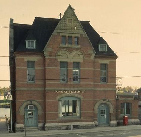
©Parks Canada Agency / Agence Parcs Canada, 1989 |
St. Stephen Post Office National Historic Site of Canada
St. Stephen, New Brunswick
The St. Stephen Post Office National Historic Site of Canada is a
splendid two-and-a-half-storey brick and stone structure executed in the
Romanesque Revival style, featuring contrasting colours and textures of
materials, a symmetrical elevation with paired entrances and a prominent
central gable with decorative carving. Prominently sited on one of the
town's major streets, it now serves as the town hall.
Built from 1885 to 1887, this building was constructed to house the
local post office, customs offices and internal revenue offices.
Designed under the federal government's chief architect Thomas Fuller,
the structure is one of a series of buildings erected with the aim of
establishing a visible federal presence throughout the country. It is a
fine example of late 19th-century design in its picturesque composition
and in the varied colours and textures of the exterior building
materials. The round-arched doors and windows and the decorative carving
show the influence of the Romanesque Revival style. Since 1965, this
building has served as the St. Stephen town hall.
|

©Parks Canada Agency / Agence Parcs Canada, 1987 |
Tilley House National Historic Site of Canada
Gagetown, New Brunswick
Tilley House National Historic Site of Canada is a one-and-a-half-storey
clapboard house located on a spacious lot in the town of Gagetown, New
Brunswick. It is believed to be the birthplace of Father of
Confederation Sir Samuel Leonard Tilley, who lived in the house until he
was thirteen years old. Typical of houses built in the 1780s in the
Maritimes, it owes its hewn timber-frame construction to the Loyalist
building tradition.
It is believed that Sir Samuel Leonard Tilley (1818 - 1896) was born in
this house. Originally built for a Dr. Stickles, probably in the late
eighteenth century, the house was purchased by Samuel Tilley, Sir
Leonard's great grandfather in 1805. It was considerably enlarged about
the time that Sir Leonard Tilley left in the 1830s, with an addition to
the north side and alterations to the original south end. By 1897, the
house had been converted for use as a hotel. It is now managed by the
Queens County Museum.
Sir Leonard Tilley spent his boyhood in this house, leaving Gagetown for
work in Saint John at the age of thirteen. By 1850 he had entered
politics, serving as Member of the Legislative Assembly for Saint John,
later Member of Parliament for Saint John and eventually
Lieutenant-Governor of New Brunswick and a federal cabinet minister. He
was knighted by Queen Victoria in 1879.
|

©Parks Canada Agency / Agence Parcs Canada, 2002 |
Tonge's Island National Historic Site of Canada
Sackville, New Brunswick
Tonge's Island National Historic Site of Canada is located on a
triangular section of land known as the Tantramar Marsh, near Sackville,
New Brunswick. An important Acadian settlement, the site consists of a
low hill covered with brackish marshland, known as Tonge's Island,
located on the western side of the Missiguash River.
In 1676, Michel le Neuf de la Vallière was granted a small section of
land on the southwest coast of the Isthmus of Chignecto, across the
Missiguash River from the small Acadian settlement of Beaubassin. La
Vallière set up his manor west of the river, on a low hill surrounded by
brackish marshland. His small settlement expanded, with the Acadians
applying their aboiteaux to slowly drain and desalinate the marshes, and
eventually a stockade and a mill were constructed.
When la Vallière became the governor of Acadia in 1678, his settlement
on Tonge's Island became the capital. The settlement served as the
capital of Acadia until 1684 when, because of a dispute with other
seigneurs over the granting of fishing licenses to Bostonian ships, the
French stripped la Vallière of his governorship. The settlement at
Tonge's Island languished for the next century while the community of
Beaubassin across the river grew into an important Acadian town. When
tensions rose between the British and French, the Beaubassin villagers
fled west across the Missiguash River to the newly built Fort Beauséjour
on the ridge north of the marsh, and their new settlement became focused
there, rather than on the less-defensible Tonge's Island.
|
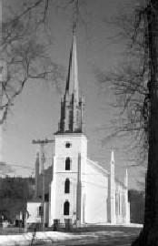
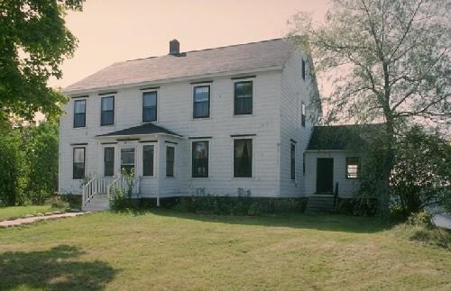
©Parks Canada Agency / Agence Parcs Canada |
Trinity Church and Rectory National Historic Site of Canada
Kingston, New Brunswick
The Trinity Church and Rectory National Historic Site of Canada consists
of a conventional Georgian designed basilican church and a two-storey
Georgian residence built in 1789. Standing on opposite sides of Route
845 in the village of Kingston, New Brunswick, they constitute a rare
example of both a church and its associated rectory surviving from the
18th century.
Loyalists arrived in Kingston in 1784, and made provisions for the
establishment of an Anglican Church. A hilltop site was selected in
1787, and both the church and the rectory were constructed by 1789.
Although the 19th century saw successive improvements and expansions in
the Gothic Revival style, Trinity Church follows the conventional
basilican pattern of a longitudinal nave with the entrance at one end
and the altar at the other. Trinity Church retains some of the
harmonious sobriety usually associated with Georgian design.
The Rectory was constructed in 1787-88 to house the first resident
minister and his family. It has retained much of its traditional,
unpretentious form, and still exhibits many characteristics of a
middle-class home of the Georgian period. The Trinity Church and Rectory
form a remarkable unit, since surviving examples of both these buildings
from the 18th century appear to be rare in the Maritimes.
|
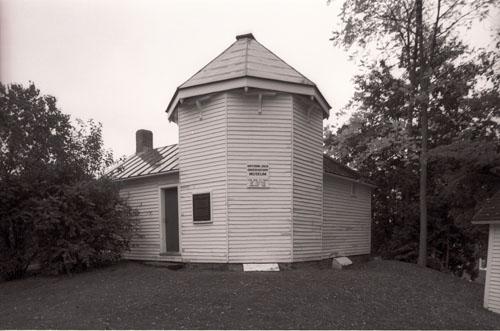
©Parks Canada Agency / Agence Parcs Canada, 1992. |
William Brydone Jack Observatory National Historic Site of Canada
Fredericton, New Brunswick
The William Brydone Jack Observatory National Historic Site of Canada is
a small structure, consisting of an octagonal tower topped with an
octagonal conical roof, with a one-storey, gable roofed portion to one
side. The building is covered with wooden clapboarding, and simple
wooden mouldings and brackets under the roof finish the exterior
surfaces. The interior volumes are also plain and serviceable.
The William Brydon Jack Observatory was built in 1851 at the instigation
of William Brydone Jack, professor of mathematics, natural philosophy
and astronomy; and president of the University of New Brunswick,
1861-65. Schooled in the traditions of Scottish universities, he
equipped the observatory with the best instruments of the day. In
collaboration with Harvard observatory he determined the longitude of
Fredericton and other places in New Brunswick, and corrected errors in
international boundaries.
|

©Parks Canada Agency / Agence Parcs Canada |
Wolastoq National Historic Site of Canada
Saint John River, New Brunswick
Wolastoq, Saint John's River National Historic Site of Canada consists
of the cultural landscape along the river extending 700 kilometres in a
broad arc from its headwaters in Québec and northern Maine to its mouth
at Saint John Harbour, Bay of Fundy. Located principally in the province
of New Brunswick, eastern Canada, the watershed represents the
traditional territory of the Wolastoqiyik First Nation. The river has
three components: the upper leg, from its headwaters in Quebec and
Maine, flows into New Brunswick past Edmundston; the middle leg, from
the confluence of the Aroostook and Tobique rivers, flows southeast to
Mactaquac; from Mactaquac the lower leg, an extensive tidal estuary of
lakes, wetlands, and islands, runs 140 kilometres to Saint John Harbour.
The entire drainage system has nurtured the Wolastoqiyik, who travelled
it, and gained nourishment from plants and animals in and around its
waters.
The heritage value of Wolastoq (Saint John River) is reflected in the
cultural landscape along the river. It also resides in the river's
important role in the life, culture, and spirituality of the
Wolastoqiyik First Nation. The Wolastoq River, its lakes and tributaries
connect with the Wolastoqiyik people through their oral histories that
give meaning to the history of the landscape as the Wolastoqiyik know
it. Wolastoq means "the Beautiful River" in the Maliseet language, while
Wolastoqiyik means "the People of the Beautiful River". While this
territory includes many sites of settlement, communication, resource
utilization, and spirituality, it is specifically the Wolastoq itself,
its lakes and tributaries that connects these sites and unites the
Wolastoqiyik as a nation. The watershed represents the traditional
territory of the Wolastoqiyik and includes many sites of settlement,
communication, resource utilization and spirituality. The many
Aboriginal place names throughout the watershed link past and present,
complementing elders' stories of traditional uses and evidence from
archaeology.
|
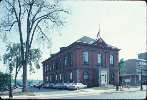
©Parks Canada Agency / Agence Parcs Canada, 1992 |
York County Court House National Historic Site of Canada
Fredericton, New Brunswick
York County Court House is a two-storey, red-brick building built in
1857-58. It is located in the downtown area of the city of
Fredericton.
York County Court House was designated a national historic site in 1980
because it is representative of a significant functional type; and it is
unique among extant court houses in the Maritimes in its amalgamation of
market and court uses under one roof.
Built in 1857-8, the York County Court House is the earliest surviving
New Brunswick court house constructed of brick. It represents the
beginning of a trend toward the widespread use of brick and stone in
public buildings in the province, primarily for reasons of fire
safety.
The building was designed to house a market on the ground floor, and
court rooms on the second storey. This combination, which arose as a
result of a restrictive land grant entered into by the county at the
beginning of the 19th century, is unique among surviving Maritime public
buildings. Given the diverse demands of the two functions, the marriage
of market and court house was never a happy one. The market space was
largely converted to court offices in 1882-3.
|
|