|
Park Summaries
Newfoundland and Labrador
All text and photos are copyrighted by Parks Canada or the Canadian Register of Historic Places
(except as noted) and were extracted from either the Parks
Canada or Canada's Historic Places
Websites. Parks with a grey background are managed by Parks Canada.
©Parks Canada Agency / Agence Parcs Canada |
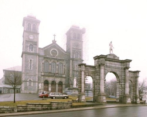
Basilica of St. John the Baptist National Historic Site of Canada
St. John's, Newfoundland and Labrador
The Basilica of St. John the Baptist is a massive, stone cathedral built
in the mid 19th century in the Lombard Romanesque Revival style. It
forms the core of a complex of religious buildings comprised of the
bishop's residence and library, a school (St. Bonaventure's College),
two monasteries and two convents. The Basilica is prominently located on
an elevated site, overlooking the city of St. John's, Newfoundland and
its harbour.
The Basilica of St. John the Baptist was designated a national historic
site in 1983 because of its important role in the religious, political
and social history of its region, and its Lombard Romanesque
architectural style.
The Roman Catholic Church has played a very important role in the
religious, political and social history of Newfoundland. The Pope
officially recognized Newfoundland as a separate ecclesiastical
territory in 1784. However, despite the significant numbers of Roman
Catholics who immigrated to Newfoundland from Ireland during the 18th
and early 19th centuries, their rights with respect to worship,
education, property and political participation were severely restricted
until 1832, when representative government was granted to Newfoundland
and restrictions on Catholics were lifted. Catholics bishops began to
play an increasingly important role in Newfoundland's social relations
and its educational system. They also maintained strong links with civil
authorities during various disputes that threatened to divide
Newfoundlanders on religious lines.
The Basilica of St. John the Baptist symbolizes the status of the Roman
Catholic Church in Newfoundland. Built between 1839 and 1850, and
consecrated as the cathedral for Newfoundland in 1855, it was elevated
to the status of a basilica a century later to reflect its historic and
religious significance. It is part of a complex of Church buildings,
constructed with the financial support of Catholics across the island,
that includes a school and two convents.
The Basilica was built under the direction of Bishop Michael Fleming,
who served as bishop from 1830 to 1850. Fleming transformed the face of
Roman Catholicism in Newfoundland while maintaining strong ties with his
European colleagues. He created many new parishes, hired permanent
resident priests and brought in two religious teaching orders of
sisters. His greatest preoccupation and most enduring achievement was
the construction of the massive cathedral on the height of land
overlooking St. John's harbour. Through his personal efforts, land,
materials and funding were secured for the building which, when built,
was North America's largest church.
The Basilica is a very early North American example of the Lombard
Romanesque Revival style. Inspired by 12th-century Italian architecture,
the style became popular in the mid-19th century for Roman Catholic
churches, especially in North America, due to its association with Rome.
The original designs called for the building to be faced with local
stone, but the builders used less expensive Irish stone instead. The
Irish stone failed under Newfoundland environmental conditions and was
gradually replaced with local stone, thereby reflecting original design
intentions, but not original materials.
The physical dominance and visibility of the Basilica reinforces the
enormous significance of the Catholic church both to St. John's and to
the province of Newfoundland.
|
©Parks Canada Agency / Agence Parcs Canada, J. McQuarrie, 2003 |
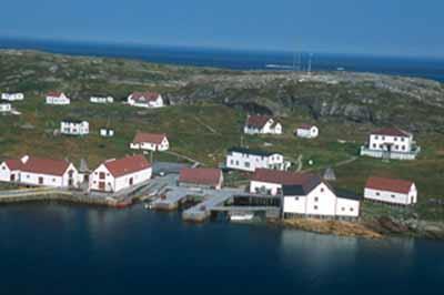
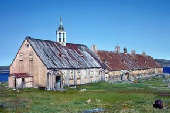
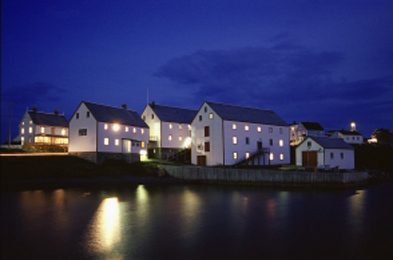
Battle Harbour Historic District National Historic Site of Canada
Battle Harbour, Newfoundland and Labrador
Located on the east coast of Labrador, Battle Harbour Historic District
is a classic example of a traditional outport fishing community. The
mercantile complex with its large wooden stores, dominates the
landscape. Wharves and fish processing spaces animate the waterfront,
while houses, a church, a doctor's office and a police detachment speak
to community life.
Battle Harbour Historic District was designated a national historic site
of Canada because, through their history, architecture and layout, the
buildings, structures and open spaces which constitute the district are
evocative of the 19th and early 20th-century fishing outports of
Newfoundland and Labrador and illuminate the rich mercantile history of
such traditional fishing communities.
The mercantile complex of Battle harbour founded by John Slade of Poole
of England in the 1770s still dominates the landscape and symbolizes the
preeminence of merchants in the economic and social order. Large
functional wooden building such as the Salt, Flour and Salmon Stores,
dating from the 18th and 19th centuries, and the wharves and fish
processing spaces, recall Battle Harbour's roles as a major port in the
Labrador fishery. The Gothic Revival Church of St. James the Apostle,
the Grenfell Mission doctor's cottage, police detachments and radio
tower represent features of the metropolis of southern coastal Labrador
up to the 1960s. Well-preserved fishing rooms, still occupied
seasonally, evoke customs of the inshore fishery, sealing, bird-hunting
and the seasonal migrations of the "livyers" of St Lewis Inlet. The
cultural landscape preserves most strikingly the rich history, tradition
and significance of Battle Harbour when it was widely acclaimed Capital
of Labrador.
|
|
Boyd's Cove Beothuk National Historic Site of Canada
Boyd's Cove, Newfoundland and Labrador
The site is positioned on a glacial moraine seven metres above sea level
along the shore of Boyd's Cove, Notre Dame Bay. It is spread throughout
a forest clearing. An archaeological study of the site identified two
areas of interest, called Area A and Area B. Area A, the northern sector
of the site, is roughly 1 250 square meters and contains evidence of
"Recent Indian" occupation and an earlier Palaeoeskimo presence. It has
yielded artefacts that predate the Beothuk occupation and attests to
continuous occupation of this site from approximately 3000 B.P. Area B,
the south part of the site, is roughly 1 760 square metres and contains
eleven Beothuk house pit features that are visible as low earthen rings
surrounding shallow depressions. Other cultural features include
middens, hearths, post moulds, and possible sleeping areas. Artefacts
predating the Beothuk from lower levels in Area B, and matching "Recent
Indian" material found in Area A and elsewhere in Newfoundland, provided
long sought after evidence of an ancestral link between Beothuk and
"Recent Indian" peoples.
Beothuk were the first North American Aboriginal people to encounter the
Europeans, but they ceased to exist as a distinct people in the early
19th century. At the time of European contact, the Beothuk occupied at
least the south and northeast coasts of Newfoundland. The Boyd's Cove
site was first located in 1981 by Dr. Ralph Pastore. His excavations
there have contributed significantly to issues that were somewhat
understood from ethnohistoric sources but had little basis in
archaeological data, including: Beothuk dwelling design and seasonal
variance of dwellings; diet; the integration of early European items
into Beothuk culture; Beothuk-European relations; Beothuk symbolism, and
subsistence procurement patterns. One of the significant outcomes of the
research was the identification of an archaeological component that
convincingly demonstrated the suspected ancestral link between earlier
"Recent Indian" groups and the Beothuk. Not only has the site
contributed to our understanding of the early historic period and to the
demise of the Beothuk, but it has also established the ancestry of these
people and affirmed the pre-contact cultural sequence in
Newfoundland.
|
©Parks Canada Agency / Agence Parcs Canada, N. Miquelon, 2006 |
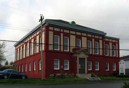
Cable Building National Historic Site of Canada
Bay Roberts, Newfoundland and Labrador
The Cable Building National Historic Site of Canada is a testament to
the development of the telegraph industry in Newfoundland and Canada in
the 20th century. Situated on Water Street in Bay Roberts, Newfoundland
and Labrador, the concrete and steel structure is Neoclassical in
design. The building is clad in red and beige brick and consists of a
single, two-storey rectangular portion with a sympathetically-designed
lateral wing. The interior spaces were designed to be open and spacious
in order to accommodate the telegraph relay station. Currently, the
ground floor houses the town hall, and the second floor is home to the
Road to Yesterday Museum and the Christopher Pratt Art Gallery.
In the late 19th century, Newfoundland became a major hub for the
development of telecommunications networks as it offered the shortest
route to link North America and Europe. In 1910, the first transatlantic
cable for the Western Union Telegraph Company was landed in a temporary
building in Bay Roberts. By 1913, the current Cable Building in Bay
Roberts was built to serve as the main relay between the North American
and European networks of Western Union Telegraph. Its establishment was
a key component in the company's international strategy and its
architectural design is important corporate evidence of the expansion
and dominance of Western Union in Newfoundland. The design of the Cable
Building also introduced a new type of telegraph station to Newfoundland
as it adopted the Western Union Telegraph corporate model. The
architecture demonstrates a functional and specialized layout with rooms
dedicated to specific equipment, technical operations, and
administration. From its technical design to the connecting cables, the
Cable Building was a flagship of telegraph technologies, illustrating
Western Union's important role as an innovative industry leader.
|
©Parks Canada Agency / Agence Parcs Canada |
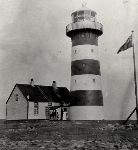
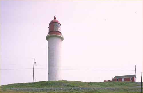
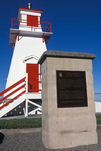
Cape Pine Lighthouse National Historic Site of Canada
Cape Pine, Newfoundland and Labrador
The Cape Pine Lighthouse National Historic Site of Canada stands high on
the most southerly promontory of Newfoundland between Trepassey and
Saint Mary's bays. The cast-iron tower is a smooth, tapered cylinder
pierced by small, square windows as it rises to a wide gallery with
railing and lantern. The lighthouse stands amongst ancillary buildings
and a communications tower. Its strategic location makes it highly
visible to maritime traffic.
The heritage value of this site resides in the physical presence of the
lighthouse as witness to the achievement of early pre-fabrication,
transportation and construction on a rugged site. Built in 1851 to guide
trans-Atlantic shipping, the Cape Pine Lighthouse also illustrates the
early improvement of aids to navigation on the east coast of Canada. The
lighthouse was the first of a series of prefabricated iron structures
erected in Newfoundland in the latter half of the nineteenth century.
Designed by Alexander Gordon, it represents a pioneering and carefully
executed instance of maritime design and engineering in Canada.
|
©Parks Canada Agency / Agence Parcs Canada, 1990 |
Cape Race Lighthouse National Historic Site of Canada
Cape Race, Newfoundland and Labrador
The Cape Race Lighthouse National Historic Site of Canada is situated on
a remote headland on the Avalon Peninsula in Newfoundland. The stone and
reinforced concrete tower consists of a smooth, plain cylinder crowned
by a circular metal lantern surrounded by a concrete walkway and
railing. The lighthouse stands amongst smaller support buildings. Its
strategic location makes it highly visible to maritime traffic.
The heritage value of this site resides in the physical presence of the
lighthouse, witness to the importance of the Cabot Strait shipping lane.
It also resides in the design and stout construction of this tower,
which housed a powerful light. The Cape Race Lighthouse also illustrates
the improvement of aids to navigation on the east coast of Canada.
Designed by Steel Concrete Co. it represents a pioneering example of
maritime design and engineering in Canada. Built in 1907 by the Canadian
government, this lighthouse, which marks the entrance to the nation's
busiest shipping lane, replaced an earlier light tower erected by the
imperial government in 1856 on the same site.
|
©Parks Canada Agency / Agence Parcs Canada |
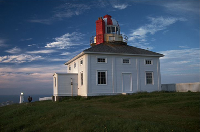
Cape Spear Lighthouse National Historic Site of Canada
Cape Spear, Newfoundland and Labrador
Oldest surviving lighthouse in Newfoundland, 1836
The oldest surviving lighthouse in Newfoundland and Labrador is located
at the most easterly point of land in North America. It has been
restored to its 1839 appearance and shows how a lightkeeper and his
family might have lived in the mid-19th century. The Visitor Centre
contains exhibits on the history of lighthouses and the tradition of
lightkeeping. The site is surrounded by spectacular scenery and wildlife
such as whales, seabirds and icebergs in season.
Set high on a bluff overlooking the approaches to St. John's harbour
Cape Spear Lighthouse is a visual icon of the province of Newfoundland.
Restored by Parks Canada to its early 19th-century core, the structure
is an elegant neoclassical cube with a domed light tower rising from its
centre. It shares its site with a functioning light, and is now operated
as a historic site open to the public.
The heritage value of Cape Spear Lighthouse lies in the remaining
physical form and materials of the 1830s lighthouse, and the strategic
location and isolated nature of its site. Built in 1835 by the Colony of
Newfoundland to signal the approach to St. John's harbour, Cape Spear
Lighthouse was in continuous operation from 1836 to 1955. The building
evolved over the years, but when it was developed by Parks Canada in
1975 as an historic site, it was restored to its 1835-1840
appearance.
|
©Parks Canada Agency / Agence Parcs Canada |
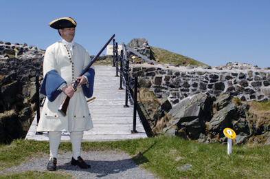
Castle Hill National Historic Site of Canada
Placentia, Newfoundland and Labrador
17th- and 18th-century French and British fortifications
Castle Hill features the remains of French and English fortifications
from the 17th and 18th centuries. Visitors can learn about the everyday
life of the French fishermen and soldiers at Placentia, Newfoundland.
The site also features a magnificent view of the town of Placentia and
the surrounding harbour.
The heritage value of Castle Hill National Historic Site of Canada lies
in its historical associations as illustrated by the remains of the 17th
and 18th-century French defence works, the British blockhouse, as well
as of both French (1692-1713) and British (1713-1811) occupancy. The
site was stabilized and interpreted by Parks Canada as a national
historic park in 1962-1968 to commemorate Placentia's tercentenary.
Archaeological investigation was conducted on the site at that
time.
|

©Parks Canada Agency / Agence Parcs Canada, J. Butterill, 1994 |
Christ Church / Quidi Vidi Church National Historic Site of Canada
St. John's, Newfoundland and Labrador
Christ Church / Quidi Vidi Church National Historic Site of Canada is a
modest, 19th-century, Gothic Revival style wood church, based on a
modified cruciform plan with a side tower. It is located on a fenced lot
on a steep hill overlooking the harbour in the former village of Quidi
Vidi, now part of the city of St. John's. The building is no longer used
as a church and the interior has been altered.
The heritage value of this site resides in its design, form and
materials. Christ Church / Quidi Vidi Church was opened in 1842 as a
chapel of ease for St. Thomas's Anglican Church in St. John's. Its
original design by James Purcell, an architect and builder, was based on
a cruciform plan with Gothic Revival detailing, an architectural form
and vocabulary favoured by the Anglican Church from the mid-19th century
to the beginning of the 20th century. Christ Church / Quidi Vidi Church
was modified by a series of additions in the 19th and 20th centuries,
including the addition of a bell tower in 1890. In its wood
construction, scale, plan and evolution, it is consistent with churches
constructed across the island of Newfoundland in outport
communities.
|

©Parks Canada Agency / Agence Parcs Canada |
Colony of Avalon National Historic Site of Canada
Ferryland, Newfoundland and Labrador
Colony of Avalon National Historic Site of Canada is a 17th-century
archaeological site located 60 kilometres south of St. John's,
Newfoundland. Situated on the east coast of the island, the site extends
across the narrow Avalon Peninsula and the small harbour at the town of
Ferryland. Ongoing archaeological excavation and research managed by the
Colony of Avalon Foundation has revealed extensive traces of the
17th-century English settlement and many related artifacts. The site now
features an interpretive centre and heritage gardens.
Intending to establish a permanent English colony in the New World, Sir
George Calvert, later Lord Baltimore, purchased a tract of land on the
east coast of Newfoundland from Sir William Vaughan in 1620. A year
later, in 1621, Calvert sent 12 settlers under the command of Captain
Edward Wynne to establish the Colony of Avalon on this land. They were
subsequently followed, in the winter of 1622-1623, by another 32
colonists, including women and children. Calvert himself visited the
colony in 1627 and settled with his family at Mansion House, in 1628.
His experience at the Colony of Avalon prompted him to ask King Charles
I to grant him land further south in Virginia due to the suffering of
the colonists. His request was granted to his son, Cecil, after his
death in 1632.
The Colony of Avalon came under the control of Sir David Kirke when he
established his headquarters at the site of present day Ferryland to
serve as Newfoundland's seat of government between 1637 and 1650. Kirke
headed a syndicate that had been given the island of Newfoundland in
1637 as compensation for the return to the French of Port-Royal and
Québec, two colonies that Kirke and his brothers, under the commission
of King Charles I, had captured in the 1620s. Kirke renamed Ferryland
"Pool Plantation" and administered colonial affairs from a house he had
taken over from Lord Baltimore's representative in the colony. In
addition to running a successful fishing business, Kirke governed
Newfoundland until 1650. Despite raids by the Dutch in 1673 and later by
the French in 1696, who burned the colony to the ground and expelled its
inhabitants, many features of the original settlement have remained and
have been exposed and identified through extensive archaeological
excavations.
|

©Parks Canada Agency / Agence Parcs Canada, N. Miquelon, 2010 |
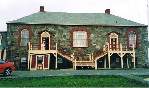
Crow's Nest Officers' Club National Historic Site of Canada
St. John's, Newfoundland and Labrador
Crow's Nest Officers' Club National Historic Site of Canada is located
on the third and fourth floors of a late 19th century brick industrial
building on Water Street near the harbour of St. John's, Newfoundland. A
staircase leads to the club's third floor, containing a kitchen and
dining room. The fourth floor, filled with furnishings, pictures and
items relating to the Battle of the Atlantic, retains the character of a
welcoming wartime gathering place for off-duty military personnel. Its
tavern-like interior contains a bar, armchairs around a fireplace, and
closely packed tables and chairs. Hanging from beams and ceiling and
arranged on walls is a large military artefact collection, while a
U-boat periscope rises through the ceiling.
The heritage value of the Crow's Nest Club also lies in its nickname
"Crow's Nest"; its function as a gathering place for thousands of
military personnel from more than a dozen nations between 1942 and 1945;
and its continued importance since May 1946 among Newfoundland navy,
army and air force officers, war veterans in general, and civilians as a
place to socialize. The Club offers a rare glimpse into the social life
of naval officers and sailors, who have imbued the place with an
atmosphere of naval tradition. The Club's well-preserved nature attests
to its significance in Canada's military and social history.
|

©Parks Canada Agency / Agence Parcs Canada, M. Stoop, 1998 |
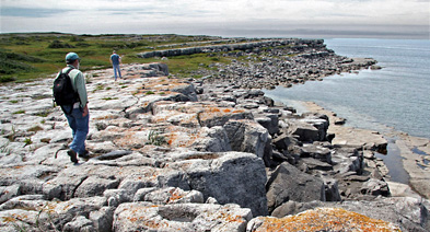
Fleur de Lys Soapstone Quarries National Historic Site of Canada
Fleur de Lys, Newfoundland and Labrador
Fleur de Lys Soapstone Quarries National Historic Site of Canada is
located in the town of Fleur de Lys on the northwestern side of Baie
Verte Peninsula, northern Newfoundland. The outcroppings of soapstone
rock, for which the site is named, are found in two areas: the first and
most extensive area extends along a bedrock ridge east of the town; the
second is a series of eleven massive soapstone boulders that lie west of
the town on the edge of Fleur de Lys Harbour. The bedrock exhibits
depressions and removal scars from the quarrying and extraction of
materials over hundreds of years. Additional sites with signs of
quarrying have been identified in the area since the designation,
although as they were not known during the sites recommendation they
have not been included in the designated place.
Fleur de Lys Soapstone Quarries is presently unique to the province of
Newfoundland in preserving considerable evidence of early methods of
soapstone extraction and techniques. Soapstone, easily quarried and
worked, was an important raw material for many of the aboriginal
societies of Newfoundland. The Dorset people, an Arctic culture who
occupied much of the province between 500 B.C.E. and 500 C.E., made
extensive use of outcrops in this vicinity to obtain blocky preforms
destined for later finishing into soapstone vessels of various shapes
and sizes, including bowls and oil lamps. Remains of vessels in
different stages of preparation are also visible in the rock faces and
mounds of tailings or spoil from the quarrying operations are found
throughout the site.
|
©Parks Canada Agency / Agence Parcs Canada, 2002 |
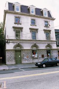
Former Bank of British North America National Historic Site of Canada
St. John's, Newfoundland and Labrador
The Former Bank of British North America National Historic Site of
Canada is located within the Heritage Conservation Area of St. John's,
Newfoundland. This impressive three-and-a-half-storey brick building
with a mansard roof, stone façade, and Italianate features housed
Newfoundland's major banks from 1849 to 1985. Today it is occupied by
the College of the North Atlantic's Anna Templeton Centre as a learning
facility.
The heritage value of the Former Bank of British North America resides
in its long-term association with banking in Newfoundland. The
building's status is reflected in its Italianate style, its substantial
institutional presence in both the interior and exterior, its
composition, and its site and setting.
The Former Bank of British North America was built in 1849 to plans by
Halifax architect David Stirling. Constructed in the Italianate style, a
style popular in Canada during this period for commercial architecture
including banks, it housed Newfoundland's first commercial bank (founded
in 1835) from 1849-1857. After that, it continued to be occupied by
major banking operations for more than a century: the new Commercial
Bank of Newfoundland (1857-1894), the Bank of Montreal (1895-1897), then
the Newfoundland Savings Bank (1897-1962) and again the Bank of Montreal
(1962-1985). A mansard roof was added to the building in 1885, leaving
its original exterior largely intact. The bank's interior was destroyed
by the Great Fire of St. John's and rebuilt in 1892-1894.
|
©Parks Canada Agency / Agence Parcs Canada |
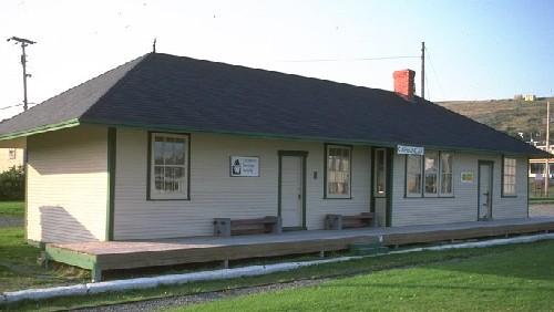
Former Carbonear Railway Station (Newfoundland Railway) National Historic Site of Canada
Carbonear, Newfoundland and Labrador
The Former Carbonear Railway Station (Newfoundland Railway) National
Historic Site of Canada is centrally located at the foot of Water Street
West in the main business district of the town of Carbonear,
Newfoundland. The site consists of a one-storey, wood-frame building
with a hipped roof and broad, overhanging eaves. The Former Carbonear
Railway Station is a representative example of stations on the
Newfoundland Railway System.
The Carbonear Railway Station is a rare surviving example of a railway
station erected by the Reid Newfoundland Company. Railway construction
began in Newfoundland in the 1880s as a way of developing the mining and
lumber industries. The financing, construction and operation of the
railway would dominate the economy and political agenda of the colony
for more than 50 years. From 1901 to 1923 the Reid Newfoundland Company,
a private company, operated the Newfoundland rail system.
The Carbonear Railway station was built in 1917 as a combined freight
and passenger station, replacing an earlier station destroyed by fire.
As a replacement station, it does not completely conform to the standard
plans used extensively by the Reid Newfoundland Company. However, it is
representative of the medium-sized, full-service, non-residential type
of station erected by the company. The station's design, with its broad,
hipped roof, overhanging eaves and wood-frame construction, is typical
of smaller stations erected by the company during the early 20th
century. The station remained the northern terminus of the Brigus
Junction to Carbonear branch line until the cessation of passenger
trains in 1984.
|

©Public Works and Government Services Canada / Travaux publics et Services gouvernementaux Canada, 1997 |
Former Newfoundland Railway Headquarters National Historic Site of Canada
St. John's, Newfoundland and Labrador
Former Newfoundland Railway Headquarters National Historic Site of
Canada is situated on the south side of Water Street, a short distance
west from the harbour's basin and dry dock in downtown St. John's,
Newfoundland. It is an elegant and dignified two-and-a-half-storey stone
building whose unique design incorporates elements of both the Second
Empire and Château styles. The building now houses the Railway Coastal
Museum.
The heritage value of the former Newfoundland Railway Headquarters lies
primarily on its association with the Newfoundland railway system and
its history. Prominent Newfoundland entrepreneur Robert G. Reid made
arrangements to build a railway in Newfoundland in 1898, although the
affiliated building was not built until 1901-1903. Its construction was
during the most politically contentious phase of the development of
Newfoundland's railway system, the fortunes of which dominated the
economy and political agenda of the colony for three decades. The
railway was conceived as a vital catalyst to the development of the
Newfoundland economy, one which by facilitating the growth of lumbering
and mining, would diversify the economy and lessen its dependency on the
fishery. The construction of the Former Newfoundland Railway
Headquarters is also one of many projects carried out by Reid under the
1898 contract, which together helped change the urban character of parts
of St. John's.
The building designed by W.H. Massey, Chief Structural Engineer for the
Reid Newfoundland Company, retains its value due to its monumental
scale, Second Empire and Château-influenced design, and prominent siting
as a reflection and representation of the importance of the railway. The
building's substantial materials as well as its craftsmanship support
this. It served as the main station and headquarters for the
Newfoundland Railway from 1903 until the railway closed in 1969. In the
early 1950s, the Newfoundland Railway was acquired by the Canadian
National Railway Company, which conducted major renovations to modernize
the building.
|
©Parks Canada Agency / Agence Parcs Canada, I.K. MacNeil, 1984 |
Fort Amherst National Historic Site of Canada
St. John's, Newfoundland and Labrador
Located on a hilly promontory overlooking the Atlantic Ocean, Fort
Amherst National Historic Site of Canada, of which there are no visible
remains, sits at South Head, the entrance to the Narrows of St. John's
Harbour in Newfoundland. Now marked by a Historic Sites and Monuments
Board of Canada plaque, the fort was strategically located to provide
for the defence of St. John's. Fort Amherst is situated within the
boundaries of Signal Hill National Historic Site of Canada.
The heritage value of Fort Amherst lies in its strategic location and
its long history of use as a military defensive installation. In 1769, a
proposal was put forth to build a battery intended to give protection to
ships which were headed for the harbour but could not enter due to high
winds. Named Fort Amherst, this battery was located at the South Head
entrance to the Narrows. Part of an extended system of defence designed
to protect British interests in Newfoundland, it was constructed between
1772 and 1777 under the supervision of Captain Robert Pringle of the
British Royal Engineers. Fort Amherst consisted of a tower and a small
battery below, eventually pierced for 20 guns. While the original
eighteenth-century fort eventually fell into ruin, Fort Amherst's
strategic importance was evident long after the colonial wars of the
eighteenth century, as evidenced by the nineteenth and twentieth-century
military installations that later occupied the site.
|

©Parks Canada Agency / Agence Parcs Canada |
Fort Townshend National Historic Site of Canada
St. John's, Newfoundland and Labrador
Fort Townshend National Historic Site of Canada, is an archaeological
site located on a hill overlooking the entrance to St. John's Harbour in
Newfoundland. The fort once formed a central part of the 18th-century
British defence network, consisting of forts and smaller batteries
strategically positioned throughout the area. The fort was abandoned in
1871, and the site has since become urban in character. In 2000, The
Rooms, a modern complex housing the Provincial Archives, Art Gallery and
Museum was built on the site. There are currently no visible
remains.
Originally built to protect one of the British Empire's key fishing
colonies from potential threats from the French, Fort Townshend
reflected Britain's commitment to the development of a residential
fishery. The fort, a star-type fortification, occupied the centre of a
system of defences, which in 1776 consisted of redoubts and batteries
extending around the harbours of St. John's, Quidi Vidi, and Torbay. Due
to the outbreak of war with France, Fort Townshend was enlarged and
strengthened in 1796, as part of changes made to the entire defence
system. In the same year, a French fleet under the command of Admiral
Richery appeared off the Narrows, but was deterred by the formidable
appearance of the defences, and the fleet withdrew. With the impending
threat from America as a result of the War of 1812, the Fort was again
refortified although no conflicts took place there.
The garrison was withdrawn from St. John's in 1871, from which date the
fort was allowed to decay. Some storage cellars with a small building,
which was used as a guardroom, still remain. While there are few
accessible remains of the fort, some may still be found in situ in the
basement of The Rooms, which was built upon the original site.
|

©Parks Canada Agency / Agence Parcs Canada, M. Dawe, 2005 |
Fort William National Historic Site of Canada
St. John's, Newfoundland and Labrador
Fort William National Historic Site of Canada, of which there are no
visible remains, is marked by a Historic Sites and Monuments Board
plaque located on a retaining wall at the corner of Cavendish Square and
Duckworth Street in downtown St. John's, Newfoundland and Labrador. The
original fort was located in an area that has been significantly altered
by urban development since the fort's demolition in 1881.
Replacing the earlier civilian-built King William's Fort after it was
destroyed in 1696, Fort William was erected in 1697 by a British
expeditionary force at a location further to the east. The arrival of a
British garrison to Fort William marked the first official military
presence in St. John's, which had previously been protected only by the
navy and local militia.
Fort William was poorly situated and was not able to effectively protect
the harbour or the settlement at St. John's. Because of its location, it
was vulnerable to land attack and was captured by the French on three
separate occasions during the 18th century. After surviving an attack by
Daniel d'Auger de Subercase in 1705, Fort William fell to the French
under Joseph de Mombeton de Saint-Ovide de Brouillon in January 1709.
Though the British rebuilt the fort later that year, the garrison did
not return and the fort began to fall into disrepair. Between 1709 and
1743, the only British garrison in Newfoundland was in Placentia, a
location thought to be more defensible than St. John's. However, when
the War of Austrian Succession (1740-1748) broke out, the British
rehabilitated Fort William, completely rebuilding it by 1749. When the
French successfully attacked the fort by land in June 1762, the British
were able to recapture it in August of that year. Finally, in 1779, the
British deemed Fort William to be too susceptible to attack and built
Fort Townshend slightly further to the west. Fort William became a minor
defence and one part of a larger system of forts and batteries that
defended St. John's and the harbours of Quidi Vidi and Torbay. In 1881,
it was demolished and its site cleared to accommodate the Canadian
Pacific Railway hotel and rail yard.
|
©Parks Canada Agency / Agence Parcs Canada, 1993 |
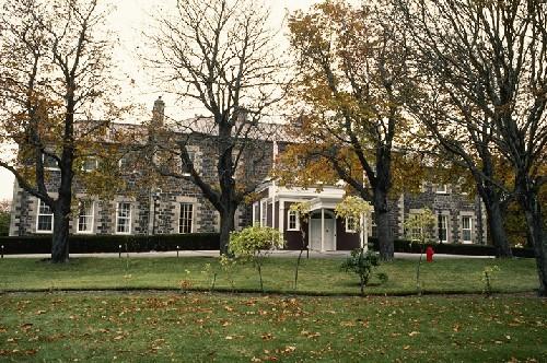
Government House National Historic Site of Canada
St. John's, Newfoundland and Labrador
The Government House National Historic Site of Canada is a large,
dignified mansion in the Palladian style. The two-storey building
consists of a centre block flanked, to its east and west, by lower
wings. The relatively plain exterior walls are of rough, red sandstone,
with contrasting English Portland stone used for quoins and other
details. The building stands in spacious treed grounds on a hill
overlooking the harbour in St. John's, Newfoundland. It has been the
official residence of Newfoundland's governors and lieutenant governors
since 1829.
The heritage value of the Government House resides in its symbolic and
functional role as an official residence and in its Palladian style
architecture as expressed by its design, material and detailing. The
site and setting also hold value. The house was built between 1827 and
1831 for Sir Thomas Cochrane, the first civil governor of the colony of
Newfoundland, and marked the transition of the colony from a naval to
civilian government. Cochrane commissioned plans from England, and the
structure was built by imported Scottish craftsmen. Once Cochrane moved
into the residence in 1829, it remained the official residence of
Newfoundland's governors until Newfoundland joined the Canadian
confederation in 1949. After that, it became the official residence of
the lieutenant governor and continues to serve as such. The building's
Palladian style remains intact and it retains much of its original
interior furnishings and fittings.
|

©Parks Canada Agency / Agence Parcs Canada |
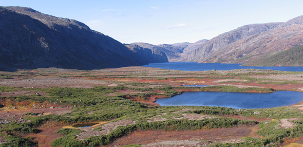
Gros Morne National Park of Canada
Headquarters: Rocky Harbour, Newfoundland and Labrador
UNESCO World Heritage Site amid Newfoundland's wild natural beauty.
Gros Morne National Park of Canada was designated a UNESCO World
Heritage Site in 1987. It is an area of great natural beauty with a rich
variety of scenery, wildlife, and recreational activities. Visitors can
hike through wild, uninhabited mountains and camp by the sea. Boat tours
bring visitors under the towering cliffs of a freshwater fjord carved
out by glaciers. Waterfalls, marine inlets, sea stacks, sandy beaches,
and colourful nearby fishing villages complete the phenomenal natural
and cultural surroundings of Gros Morne National Park of Canada.
|
©Parks Canada Agency / Agence Parcs Canada, Bryan Horton, 2005 |
Harbour Grace Court House National Historic Site of Canada
Harbour Grace, Newfoundland and Labrador
Harbour Grace Court House is a two-storey stone institutional building
that stands at 2 Harvey St. in Harbour Grace, Newfoundland.
Distinguished by a large central window flanked by two entry doors
accessed by a split staircase, its design reflects the form and
classically inspired aesthetic, typical of many British colonial
courthouses. The building included a jail and the jailer's modest
residence is still attached to one end of the courthouse.
Harbour Grace Court House was built in 1830 in one of Newfoundland's
earliest and most prosperous settlements. It replaced an earlier
courthouse with one of more substantial construction containing
facilities for a court, a jail and jailer's residence. It was originally
designed and built by Patrick Kough [also known as Keough], a
Newfoundland resident, and has been restored since 1980.
The heritage value of Harbour Grace Court House National Historic Site
resides in its age and longterm status as a public building as well as
in the substantial, distinguished nature of its construction and
architectural form.
|

©Parks Canada Agency / Agence Parcs Canada |
Hawthorne Cottage National Historic Site of Canada
Brigus, Newfoundland and Labrador
Picturesque cottage, home of Captain Bob Bartlett from 1875-1946
Hawthorne Cottage was the Brigus, Newfoundland, home of famous Arctic
explorer Captain Bob Bartlett. The cottage is a fine example of the
Picturesque style of architecture in Newfoundland and is furnished with
artifacts and memorabilia from Captain Bob's voyages.
Hawthorne Cottage National Historic Site of Canada is a picturesque,
one-and-a-half storey wooden cottage with a wrap-around verandah. Set in
the middle of a wooded lot in Brigus, Newfoundland, the house is noted
both for its architectural style and as the former home of Bob Bartlett,
captain of several notable Arctic expeditions in the early 20th century.
The site was donated to the Canadian people in 1987 and is now
maintained by Parks Canada as a historic house museum.
The heritage value of the site resides in its association with Captain
Bob Bartlett and in its picturesque architecture. Built in 1830 for
merchant John Leamon on his country estate, Cochranedale, the house was
moved overland some ten kilometers to a lot in Brigus during the winter
of 1833-1834. Between 1885 and 1946, it was the Brigus home of Robert
Abram (Bob) Bartlett (1875-1946), designated a person of national
historic significance because of his role in several Arctic expeditions.
The house was acquired by Parks Canada in 1987, restored and opened to
the public in 1995.
|
©Parks Canada Agency / Agence Parcs Canada, I.K. MacNeil, 1994 |
Hebron Mission National Historic Site of Canada
Hebron, Newfoundland and Labrador
The surviving elements of Hebron Mission National Historic Site of
Canada consist of a long interconnected series of buildings, including a
church, mission house, and finally a store. The design has a Germanic
flavour characterized by the steep, elongated roof punctuated by small
dormer windows. The cupola is typical of church architecture of
south-eastern Europe, from whence came the Moravians. Other buildings,
including a forge, carpenter's shop, and other support structures are
gone.
The mission buildings at Hebron, on the northeast coast of Labrador,
were erected by the Church of the Brethren, more commonly called the
Moravians. This mission was one of several built by the Moravians and it
is possible that these buildings were pre-fabricated in Germany and
shipped to this location. Construction began in 1829 but the site was
not ready for habitation until 1837. The Moravians also engaged in
trade, medical practice, and the administration of justice. This mission
closed in 1959.
|
©Parks Canada Agency / Agence Parcs Canada, David Henderson, 2007. |
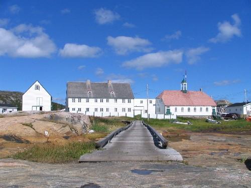
Hopedale Mission National Historic Site of Canada
Hopedale, Newfoundland and Labrador
Symbol of interaction between Labrador Inuit and Moravian Missionaires;
representative of Moravian Mission architecture in Labrador
Hopedale Mission National Historic Site Canada is a complex of large,
wooden buildings constructed by the Moravian Church at Hopedale,
Labrador. These large, wooden structures stand starkly silhouetted
against the rocky shoreline of the vast, barren landscape.
The heritage value of Hopedale Mission National Historic Site of Canada
lies in the common purpose, spatial, architectural, and functional
relationships of the grouped buildings in this complex, and in their
architectural expression as illustrations of Moravian mission
architecture.
The Moravian Mission at Hopedale was established in 1782. Today Hopedale
Mission National Historic Site of Canada contains seven buildings: the
Early Mission Building, the Mission House (workshop wing), the Mission
House (main wing), the Church, a connecting link between the Church and
the Mission House (all completed by 1850-1861), the Reserve Storehouse
(1892), and the Dead House (1861). The Oil and Salt Storehouse that was
in this complex of buildings when they were designated in 1970 and was
demolished in 1999.
|
©Parks Canada Agency / Agence Parcs Canada, Heiko Wittenborn |
kitjigattalik - Ramah Chert Quarries National Historic Site of Canada
Torngat Mountains National Park, Newfoundland and Labrador
Kitjigattalik is the source of a distinctive translucent stone known as Ramah
chert, found only in Torngat Mountains National Park in northernmost Labrador.
Actively quarried from 5,000 to 600 years ago by several ancient First Peoples
cultures of the northeast, Ramah chert was used in the manufacture of everyday
tools and other objects. The most widely traded tool stone known in the Canadian
Northeast, it figured in long-distance exchange networks that extended
throughout eastern Canada and into New England. Objects of Ramah chert have been
found at archaeological sites along the entire length of the Labrador coast,
along the Quebec North Shore, in the interior of Labrador and Quebec, in Ungava
Bay, on Southampton Island, Baffin Island, on the Island of Newfoundland, in the
Maritimes and in New England. One piece has been recovered as far south as
Maryland, while the westernmost find was in Peterborough, Ontario. One specimen
was even found during archaeological excavations in 1935 at the Norse settlement
of Sandnes in Greenland. The study of Ramah chert has revealed something of the
complexity of ancient trade systems and economies, and the important role that
exchange played in keeping cultures alive. It has allowed an understanding of
the long-distance travel capabilities and the inter-connectedness of ancient
peoples who are too often assumed to have lived in isolation.
First discovered by the earliest Archaic settlers of Northern Labrador, Ramah
chert was the tool stone of choice for many successive cultures despite the
remote location of the quarries and the difficulties of travel along northern
Labrador's forbidding coastline. The distances involved in reaching the quarries
and then transporting the material southward were evidently factors of less
importance than its desirability.
At certain periods, Ramah chert appears to have been closely aligned with
cultural identity. This was the case during the late Archaic period in northern
Labrador, the late Dorset period in northern Labrador, and throughout the Late
Precontact period for Amerindian groups living along the length of the Labrador
coast. It is notably linked to early belief systems and burial practices.
Objects of Ramah chert are found in late Archaic-period burials (ca. 4,500 years
ago) extending from northern Labrador to New England. It is quite likely that
the quarries themselves were also imbued with symbolic meaning. Symbolic value
is reflected in the unusual caches of carefully made Ramah chert objects that
have been discovered in southernmost Labrador, which appear to have had no
practical purpose. Symbolism and cultural identity are equally evident in the
Late Dorset Palaeo-Eskimo and Late Precontact Innu periods of Labrador (spanning
from 1,200 to 600 years ago) when Ramah chert was the only stone used to make
tools, despite the availability of many other high quality tool stone
varieties.
|
|
Indian Point National Historic Site of Canada
Red Indian Lake, Newfoundland and Labrador
Well documented Beothuk site.
|

©Parks Canada Agency / Agence Parcs Canada |
L'Anse Amour National Historic Site of Canada
L'Anse Amour, Newfoundland and Labrador
L'Anse Amour National Historic Site of Canada overlooks the waters of
the Strait of Belle Isle near the small modern community of L'Anse Amour
in southern Labrador. The burial mound forms part of an ancient,
multi-component archaeological site occupied by the Maritime Archaic
people between 9000 and 2000 years ago. Formed by a low mound of large
stones, the circular burial mound is 8-10 metres in diameter and
situated behind what was the main habitation area. Within the mound is a
small stone burial chamber underneath which was found the well-preserved
skeleton of a child along with a number of artefacts.
L'Anse Amour is the oldest known burial mound in the North America, and
is part of one of the largest and longest used Aboriginal habitation
sites in Labrador. The body had been covered with red ochre, wrapped in
a shroud of skins or birch bark, and placed face down, head pointed
west, in a large pit 1.5 metres deep. Evidence also indicates the use of
ceremonial fires and the cooking and consumption of food. Offerings were
made of tools and weapons made of stone and bone. These included a
walrus tusk, a harpoon head, paint stones and a bone whistle.
|
©Parks Canada Agency / Agence Parcs Canada |
L'Anse aux Meadows National Historic Site of Canada
St. Anthony, Newfoundland and Labrador
Only authenticated Viking settlement in North America
The reconstructions of three Norse buildings are the focal point of this
archaeological site, the earliest known European settlement in the New
World. The archaeological remains at the site were declared a UNESCO
World Heritage Site in 1978. Exhibits highlight the Viking lifestyle,
artifacts, and the archaeological discovery of the site. Visitors can
also explore the hiking trails to nearby bays and lakes.
L'Anse aux Meadows National Historic Site of Canada comprises the
archaeolgical remains of an early Viking settlement situated on the
eastern shore of Epaves Bay, 1 km south of the village of L'Anse aux
Meadows at the tip of the Great Northern Peninsula in Newfoundland.
Parks Canada has erected a partial reconstruction of the habitation for
purposes of public presentation.
The heritage value of the site lies in the archaeological evidence of
early Viking presence in Canada. The location, surroundings and
disposition of the site together with the nature of the remains it
contains provide both an essential record and legible description of
Viking life on the site. In ca. 1000 AD, l'Anse aux Meadows was
established as exploration base Leifsbuoir/ Straumfjord, popularly known
as Leif Ericsson's short-lived Vinland camp. It has been conserved and
interpreted as a national historic site of Canada.
|

©Parks Canada Agency / Agence Parcs Canada, 1993 |
Mallard Cottage National Historic Site of Canada
St. John's, Newfoundland and Labrador
Mallard Cottage is a picturesque one-and-a-half storey wood-frame house
set on a small lot near the road in the hamlet of Quidi Vidi, a suburb
of St. John's Newfoundland.
Mallard Cottage was designated a national historic site of Canada
because, with its hipped roof and central chimney, it is typical of the
vernacular housing built by immigrants from southeastern Ireland in the
first half of the nineteenth century.
The heritage value of this site resides in the materials as well as the
elements of vernacular design and craftsmanship deriving from
Irish-Newfoundland vernacular building traditions. The Mallards, a
family of Irish origin, lived in the house for over a hundred
years.
|
©Parks Canada Agency / Agence Parcs Canada |
Akami-uapishku - KakKasuak - Mealy Mountains National Park Reserve of Canada
Headquarters: Newfoundland and Labrador
The focal point of the park reserve is the Mealy Mountains themselves -
the rugged mountains that give the area its name. Their
glacially-rounded and bare rock summits, which overlook Lake Melville,
reach to 1,100 metres.
Easterly from the mountain tundra of the Mealy Mountains is a dramatic
transition to a lush forested landscape, which gently descends toward
the coast until it meets the frigid waters of the Labrador Sea. This is
a landscape of undisturbed watersheds and pristine wild rivers with
breathtaking rapids and waterfalls.
The beautiful White Bear, North and English rivers include both Atlantic
salmon and trout, and their valleys will offer exceptional hiking
opportunities to visitors. Where the park reserve fronts the Labrador
Sea, an extensive, 50-kilometre stretch of unbroken sandy beaches known
as the Wunderstrand can be found. This spectacular beach is recorded in
Viking sagas relating their voyages of exploration along the Atlantic
Coast.
The park reserve will play an important role in wildlife conservation.
It protects a significant portion of the range of the threatened Mealy
Mountains caribou herd, including key habitat along the coast and on
offshore islands. Extensive landscapes of boreal forest, which are home
to caribou, wolves, black bear, marten and fox can be found both just
north of Sandwich Bay as well as along the south shore of Lake Melville.
Toward the south, extensive wetlands provide important habitat for
migratory birds such as ducks and geese.
|
©Sean Graham, Parks Canada Agency / Agence Parcs Canada, 2019 |
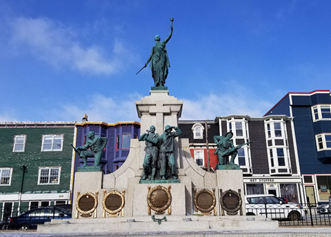
Newfoundland National War Memorial National Historic Site of Canada
St. John's, Newfoundland and Labrador
Unveiled in 1924 to commemorate the Dominion of Newfoundland's contributions to
the First World War, the Newfoundland National War Memorial is an imposing
monument featuring a rare combination of allegorical and realistic bronze
sculptures designed by British artists Gilbert Bayes and Ferdinand Victor
Blundstone. Its design elevates a victorious Spirit of Newfoundland over figures
of a sailor from the Newfoundland Royal Naval Reserve, a soldier from Royal
Newfoundland Regiment, a lumberman from the Forestry Corps, and a fisherman in
oilskins and Wellington boots, providing a tangible connection to Newfoundland
and Labrador and those who served overseas and on the home front. Located next
to where Newfoundland soldiers departed and returned from the First World War,
it is a physical and visual landmark in downtown St. John's.
The memorial features five bronze sculptures on a large granite base, the
largest of which, a female figure representing the Spirit of Newfoundland who
holds a flaming torch in her left hand high above her head, stands atop the
central pedestal. The torch, which symbolizes freedom, is the memorial's highest
point, prioritizing freedom as a central motivation for Newfoundland's wartime
contributions. In her right hand, she holds a sword which represents both
Newfoundland's willingness to serve during the First World War and loyalty to
the British Empire. The sword is below her waist, but not completely lowered,
and poised for battle, and is meant to depict that while the war is over,
Newfoundland was, and is, ready and willing to fight for its freedom and
liberty.
On the front of the monument below the figures are five plaques commemorating
Newfoundland and Labrador's contributions in different conflicts. In the centre,
the original plaque from 1924 honours those killed during the First World War.
Plaques for the Second World War, Korean War, Afghanistan, and War of 1812 have
been added.
The monument sits between Water and Duckworth streets. While the city's natural
topography slopes towards St. John's Harbour, the grade at the site was altered
prior to construction with the slope making the monument appear larger and more
imposing in its setting. This visual effect extends to St. John's Harbour and
gives the memorial a grand appearance when seen from the water. The flaming
torch held by the Spirit of Newfoundland figure was originally intended to be a
leading light for ships entering St. John's Harbour through the Narrows,
although it was never used as such.
The location also has historic significance as it was where Sir Humphrey Gilbert
claimed Newfoundland for England in 1583. The memorial is also located where the
Custom House stood before the Great Fire of 1892 destroyed most of downtown St.
John's.
|
©Parks Canada Agency / Agence Parcs Canada, 1993 |
Mallard Cottage National Historic Site of Canada
St. John's, Newfoundland and Labrador
Mallard Cottage is a picturesque one-and-a-half storey wood-frame house
set on a small lot near the road in the hamlet of Quidi Vidi, a suburb
of St. John's Newfoundland.
Mallard Cottage was designated a national historic site of Canada
because, with its hipped roof and central chimney, it is typical of the
vernacular housing built by immigrants from southeastern Ireland in the
first half of the nineteenth century.
The heritage value of this site resides in the materials as well as the
elements of vernacular design and craftsmanship deriving from
Irish-Newfoundland vernacular building traditions. The Mallards, a
family of Irish origin, lived in the house for over a hundred
years.
|

©Parks Canada Agency / Agence Parcs Canada, Jim Molnar, 2005 |
Okak National Historic Site of Canada
Okak, Newfoundland and Labrador
Okak National Historic Site of Canada is a grouping of over 60
archaeological sites dating from 5550 B.C.E to the present, which are
located on Okak Bay off the northern coast of Labrador. The sites are
spread across three nodes of varying landscapes: the forested mainland
surrounding Okak Bay, which lies just south of the tree line; the
partially forested inner islands, with small stands of spruce and
patches of brush; and the outer (seaward) islands, which are
characterized by a landscape of bare rock and tundra vegetation. The
sites cluster near the shore on raised beach terraces where cultural
material may be found in both surface and buried contexts. Foundations
of buildings, walkways and a wharf from Okak Mission, located on Okak
Island, are visible amid vegetation on tundra-covered hills.
The archaeological remains found at Okak span more than 6000 years,
including its occupation by Maritime Archaic (5550 B.C.E.- 1550 B.C.E.),
Pre-Dorset (1850 B.C.E. — 250 B.C.E.), Intermediate Indian (1550 B.C.E.
— 250 B.C.E.), Dorset (550 B.C.E. — 1450 C.E.) and Labrador Inuit (1200
C.E. — Present) cultures. Many of the sites are multi-component,
incorporating occupations during two or more of these cultural periods.
A range of site types, from small surface scatters to groups of sod
houses are represented within the site. The cultural material consists
primarily of stone tools and flakes documenting changes in tool form,
manufacturing techniques, and raw material sources among the various
cultural periods. The oldest archaeological finds date from the Maritime
Archaic period on Cut Throat Island.
In 1776, Moravian Missionaries established a mission site in northern
Labrador, and settled off Okak Harbour on Okak Island. It was the second
successful mission to be established by the Moravian Missionaries on the
Labrador Coast, the first being founded at Nain, 400 kilometres to the
south in 1771. The Okak Mission was prefabricated at Nain, and then
transported north to Okak, along with a provisions house and bake house.
Inuit houses were also constructed here as families gradually relocated
to be closer to the mission. Between changing hunting patterns and the
Spanish Influenza epidemic of 1918-1919, which decimated the population
at Okak, the mission was abandoned in 1919.
|
©Parks Canada Agency / Agence Parcs Canada |
Port au Choix National Historic Site of Canada
Port au Choix, Newfoundland and Labrador
Pre-contact burial and habitation sites.
Port au Choix, on the west side of Newfoundland's Great Northern
Peninsula, has been populated for thousands of years. The rich waters
off this coast have supported many different groups of people, including
those who live here today. The remains of four ancient cultures have
been found at Port au Choix to date: Maritime Archaic Indian, Dorset and
Groswater Paleoeskimo, and Recent Indians. Archaeologists searched many
years for a site such as this one, which sheds new light on our
understanding of native peoples in this part of the world.
Port au Choix National Historic Site of Canada consists of two
exceptionally rich pre-contact archaeological sites located at Port au
Choix Newfoundland where the Port au Choix and Point Riche peninsulas
jutting into the Strait of Belle Isle are joined by a narrow isthmus.
Constructed from approximately 4,400 BCE to 1,300 BCE, both sites are
located on long, flat raised terraces running beside the water. The
designation refers to both a Maritime Archaic cemetery in the form of a
burial terrace overlooking Back Arm and also the Phillip's Garden
Palaeo-Eskimo habitation site; a flat grassy place situated on the outer
shore of the Point Riche Peninsula where land forms and vegetation
indicate the remnants of two early settlements scattered over an area of
some two hectares.
The heritage value of Port au Choix National Historic Site of Canada
resides in the site itself and in the exceptional rarity, richness and
quality of the archaeological evidence its two designated places
contain. Considerable archaeological investigation has occurred on these
sites under the auspices of Parks Canada and the Province of
Newfoundland and Labrador.
|

©Parks Canada Agency / Agence Parcs Canada, R. Goodspeed, 1998 |
Port Union Historic District National Historic Site of Canada
Trinity Bay North, Newfoundland and Labrador
The Port Union Historic District is the original part of a small town on
the south of the Bonavista Peninsula in Newfoundland. Dominated by
imposing commercial buildings on the harbour, it rises up a rocky
hillside with scattered clusters of wooden houses and outbuildings. An
associated hydroelectric station lies almost a kilometre and a half to
the west on the Catalina River.
Port Union is the only town in Canada founded by a union. In 1916, the
Fishermen's Protective Union, led by William Coaker, began constructing
buildings along an empty stretch of shoreline. By 1926, the union had
established premises for its retail, export, shipbuilding and publishing
companies; the town also included a large meeting hall, a railway
station, a church, and duplexes for workers. A hydro-electric plant,
located over a kilometre away, supplied the community. The town's
original layout and many intact buildings speak to its commercial and
industrial success during is heyday (1918-1925) as a vibrant
international port.
|

©Parks Canada Agency / Agence Parcs Canada |
Red Bay National Historic Site of Canada
Red Bay, Newfoundland and Labrador
16th-century Basque whaling industry complex.
Right and bowhead whales, once plentiful in the waters of coastal
Labrador, attracted whalers from the Basque region (northern Spain and
southern France) during the 16th century. A thriving industry based on
the production of whale oil for export to Europe developed along the
Labrador coast during the mid to late 1500s. The busiest port for this
historic enterprise was the sheltered harbour of Red Bay.
Red Bay National Historic Site of Canada encompasses one of the most
protected harbours on the coast of the narrow Strait of Belle Isle
between Labrador and the northern tip of Newfoundland. The site extends
from the reddish coloured bluffs around the harbour to its islands and
shoreline. It also extends from the bottom of the harbour basin to the
hills and vantage points surrounding it. The harbour holds remains of
16th-century Basque whaling ships and the beaches and shorelines hold
relics of the shore stations that once supported a thriving whaling
industry.
The heritage value of the site lies in the evidence of Basque whaling
activities provided by the landscape and the surviving remains of the
16th-century whaling activity found there. Red Bay National Historic
Site of Canada was one of the largest whaling ports used during the
1550-1620 period by whaling expeditions sponsored by Basque merchants
from France and Spain. In search of whale oil, they sent European
fisherman to the Strait of Belle Isle, and then mounted regular seasonal
expeditions from harbours along its coast to the south coast of Labrador
and the north shore of Québec. Red Bay is of particular value because
the remains within the site are numerous, diversified, and exceptionally
well preserved.
|

©Parks Canada Agency / Agence Parcs Canada, J.F. Bergeron, 2002 |
Rennie's Mill Road Historic District National Historic Site of Canada
St. John's, Newfoundland and Labrador
Rennie's Mill Road Historic District National Historic Site of Canada is
an upper middle-class residential suburb located just beyond the centre
of St. John's, Newfoundland. Comprised of a harmonious group of large,
wooden houses from the late 19th to the early 20th centuries, whose
owners were for the most part prominent Newfoundlanders, it includes
fine examples of Second Empire and Queen Anne Revival-style domestic
architecture, set on well-treed lots.
Built after the Great Fire of 1846, Rennie's Mill Road Historic District
was a safe and tranquil retreat from downtown St. John's. The heritage
value of the district resides in it association with prominent
Newfoundlanders and in the physical illustration of a prosperous,
stylish suburb of the late 19th and early 20th centuries.
|
©Parks Canada Agency / Agence Parcs Canada |
Ryan Premises National Historic Site of Canada
Bonavista, Newfoundland and Labrador
East Coast fishing industry complex.
The Ryan Premises, a restored merchant's premises, commemorates the role
of the East Coast fishery in Canadian history from the early 1500s to
the present day.
Ryan Premises National Historic Site of Canada is a cultural landscape
associated with the fishery. It consists of domestic and commercial
structures typical of a 19th-century Newfoundland mercantile complex in
their original setting by the sea, adjacent to the intersection of
Ryan's Hill and Old Catalina Road, in Bonavista.
The heritage value of Ryan Premises lies in its long association with
the Atlantic fishery and in its related physical resources, including
the buildings in their setting in the historic community of Bonavista.
The Ryan's company was established in Bonavista in 1857 as James Ryan.
Over the years, the company expanded its activities to King's Cove
(1874, as James Ryan and Company) and Trinity (1906, as Ryan Brothers)
to accommodate the Labrador fishery. The company continued to engage in
the salt fishery until 1978. It is now operated as a historic site open
to the public.
|
©Parks Canada Agency / Agence Parcs Canada |
Signal Hill National Historic Site of Canada
St. John's, Newfoundland and Labrador
Commemorates defence of St. John's; includes the Cabot Tower.
Signal Hill National Historic Site of Canada, located at the
northeastern end of St. John's harbour, is composed of two cultural
landscapes — Signal Hill itself and the south side of the Narrows.
Signal Hill is the steep hill that frames the entrance on the north side
of St. John's Harbour from St. John's Bay. Identifiable by the
castellated profile of Cabot Tower, Signal Hill descends gently in
ridges and valleys towards St. John's to the west and Quidi Vidi
waterway to the north. Across the Narrows, a ribbon of land at the base
of the steep Southside Hills contains several fortification and
communication sites including Noone Room, South Castle, Frederick's
Battery and Fort Amherst National Historic Site of Canada. Today the
historic place of Noone Room and its mooring area known as Ring Noone
are buried beneath an industrial marine boat basin built in the 1980s.
Signal Hill was designated a national historic site of Canada because it
is importantly associated with Canada's defence and communications
history. The heritage value of Signal Hill lies in the historical
associations of both sides of the Narrows as illustrated by the physical
resources of the two cultural landscapes, including their locations,
settings, natural and built resources, particularly evidence of defence
and communications activities.
Signal Hill has been a military site since the 17th century, but most
importantly during the four periods 1660-1697, 1697-1870, World War I,
and World War II. Today it contains a broad range of military and
civilian resources, among them works on the south side of the harbour
narrows, notably the remains of Fort Amherst, a British fortification
completed by Captain Robert Pringle, R.E. in 1777 to guard the entrance
to the Narrows. Fort Amherst was also declared a national historic site
of Canada in 1951. The hill was also the site of the Battle of Signal
Hill (15 September 1762) when Lieutenant Colonel William Amherst led an
expeditionary force to recapture St. John's from the French, itself an
event of national significance.
The history of signaling on Signal Hill embodies the fundamentally
modern transition from visual signals to wireless ones. Signal Hill is
the site of the Cabot Tower, built between 1898 and 1900 to continue the
port signaling service which originated in 1704; flag signaling
continued from the deck of Cabot Tower until 1958. On 12 December 1901
Guglielmo Marconi received the first transoceanic wireless signal in a
former military barracks on Signal Hill. From 1933 to 1949 the Canadian
Marconi Co. operated a wireless station on the second floor of Cabot
Tower; from 1949 until 1960, the Canadian Department of Transport
operated the station.
|

©Parks Canada Agency / Agence Parcs Canada, J.F. Bergeron, 2002 |
St. John the Baptist Anglican Cathedral National Historic Site of Canada
St. John's, Newfoundland and Labrador
St. John the Baptist Anglican Cathedral National Historic Site of Canada
is an austerely magnificent stone cathedral built in the Gothic Revival
style. It is located on a hillside overlooking the harbour of St. John's
in a mixed commercial and residential neighbourhood of late-19th-century
buildings.
Construction of the original St. John the Baptist Anglican Cathedral,
for Canada's oldest Anglican parish, began in 1847. It was built under
the direction of Right Reverend Edward Field, Bishop of Newfoundland,
and designed by the well-known English church architect George Gilbert
Scott. The Cathedral is a faithful example of Scott's ecclesiastical
work, which conformed to the tenets of the Cambridge Camden Society. The
Society was dedicated to recapturing the spirit and form of 13th-century
Gothic church architecture. This was of particular significance in the
British colonies, where a prescriptive approach to church design was
intended to create a distinct and recognizable Anglican architectural
identity consistent with the Anglican creed.
St. John the Baptist Anglican Cathedral, as designed by Scott, fully
reflected the Society's intentions and expectations. It was a correct
Ecclesiological interpretation of Gothic architecture as articulated by
the English architectural theorist A.W.N. Pugin. It occupied a dramatic
site on the side of the hill near the harbour of St. John's, which added
to its monumentality. Constructed of Irish limestone and local
sandstone, its symbolic cruciform plan, tall ceiling and interior
arrangement followed Ecclesiological tradition. In 1892 the unfinished
cathedral was almost completely destroyed during one of the great fires
of St. John's. Using surviving exterior walls, the architect's son
George Gilbert Scott Jr. rebuilt the cathedral according to his father's
original plans, with careful attention paid to local climatic
conditions. It remains an early and fine example of the ecclesiological
Gothic Revival style in North America. Its setting in a well-preserved
turn-of-the-century neighbourhood strengthens the original design
intentions.
|
©Parks Canada Agency / Agence Parcs Canada, 1993 |
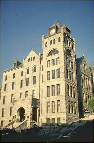
St. John's Court House National Historic Site of Canada
St. John's, Newfoundland and Labrador
St. John's Court House is a imposing, early-20th century, granite and
sandstone, Romanesque Revival-style public building, prominently located
on the main commercial street of the city of St. John's, Newfoundland.
Its siting on a steep hill overlooking the harbour, permits unhindered
views to and from the harbour.
St. John's Court House was designated a national historic site in 1980
because it is representative of the judicial institution in
Newfoundland; and it is the most striking and elaborate court house in
the province.
Built in 1901-04 to replace an earlier courthouse and market on the same
site, the St. John's Courthouse was designed to house the Supreme Court,
Police Court, judges' chambers, law library, and the Colonial
Secretary's office. For a brief time the legislature also met here. It
continues to be used as a court house today. Designed by architect
William H. Greene, the monumental scale and Romanesque Revival-style
design of the building convey an impression of solidity and power
appropriate to its legal function. The building's commanding presence is
accented by its dramatic siting on a steep hill overlooking the St. John
Harbour. The heavy grandeur of its exterior is matched by the elaborate
wood detailing of the interior.
|
|
St. John's Ecclesiastical District National Historic Site of Canada
St. John's, Newfoundland and Labrador
St. John's Ecclesiastical District National Historic Site of Canada is a
large, linear shaped parcel of land located in St. John's Newfoundland,
overlooking the north side of Saint John's Harbour. The district,
located in the centre of town, is largely composed of 19th- and
20th-century buildings and landscape features associated with the Roman
Catholic, Anglican, United (formerly Methodist) and Presbyterian
denominations. All but one of the buildings are of masonry construction.
The district includes three separate nodes in the downtown area. The
first, most northern node contains eight buildings and a cemetery. The
second node, to the east, includes a number of largely interconnected
buildings, the centrepiece of which is the Basilica of St. John the
Baptist National Historic Site of Canada. The third, most southern node
contains seven buildings associated with three Protestant denominations,
including St. John the Baptist Anglican Cathedral National Historic Site
of Canada.
St. John's Ecclesiastical District was designated a National Historic
Site of Canada in 2008 because: this cultural landscape represents the
breadth of involvement of the Anglican, Roman Catholic, Methodist/United
and Presbyterian denominations in the establishment and evolution of the
spiritual, philanthropic, charitable and educational institutions of St.
John's and Newfoundland during the 19th and 20th centuries, as well as
in the political life of the colony; it speaks to the evolution of the
province's unique denominational system of education, established in
stages from 1832 to 1879 and lasting until 1998, and especially to the
competition among the denominations that brought this system about; it
is important architecturally for its ecclesiastical buildings and spaces
in unusual proximity to each other and located on an outstanding and
unique site on the steep hill overlooking St. John's Harbour, where many
of them serve as visual landmarks both from the harbour and within the
downtown. The Roman Catholic precinct in particular conveys a sense of
time and place through its architecture and spaces.
St. John's Ecclesiastical District is valued for its historical
associations with religion and education in Newfoundland and Labrador.
The four denominations represented in the district made considerable
contributions to the spiritual, educational, charitable, and political
fabric of society. The Roman Catholic Church led by Bishop Michael
Anthony Fleming and later by Bishop John T. Mullock, created
institutions such as the Orphan Asylum School, the Presentation Convent
and St. Bonaventure's College to provide education for the Catholic
community. With the help of the Benevolent Irish Society (BIS), several
orders of nuns, and the order of the Irish Christian Brothers, a
Catholic system of education was established. Other denominations also
contributed to education with similar initiatives. For example, Bishop
Edward Field, the second Anglican bishop of Newfoundland, founded the
Bishop Feild Collegiate in 1844. The Presbyterians and Methodists
founded similar educational facilities, such as the Wesleyan-Methodist
College in 1858 and the General Protestant Academy in 1876.
Newfoundland's unique denominational system began with the first
Education Act, passed in 1836, in support of a non-denominational system
of education. However, in 1843, Protestant-Catholic friction on the
school boards produced the second Education Act, which established
separate boards for Protestants and Catholics and allotted grants to
other denominational schools. Among the proponents of the system was
Bishop Feild, who helped create a system of separate academies (for
Catholics, Anglicans, and "General Protestants") in 1850. In 1875, the
denominational system came into effect, which legislated division of
educational grants according to denominational strength, and made
education the responsibility of state-subsidised individual churches.
The system was entrenched in the Terms of Union and continued until 1998
when it was replaced by a secular system of education.
St. John's Ecclesiastical District is also valued for its architectural
importance. Located on a steep hill overlooking St. John's Harbour, it
serves as a visual landmark from the harbour and downtown. It includes
many ecclesiastical buildings and spaces in unusual proximity to each
other, such as St. John the Baptist Anglican Cathedral, founded by
Bishop Feild in 1846. Overall, visual impact is achieved through the use
of varying materials, architectural styles, and open spaces.
|
|
St. John's WWII Coastal Defences National Historic Site of Canada
St. John's, Newfoundland and Labrador
St. John's WWII Coastal Defences National Historic Site of Canada is a
defence complex strategically located at the approaches and entrance of
St. John's inner harbour on the east coast of Newfoundland. The site
comprises the ruins of three coastal fort batteries: Fort Cape Spear,
Fort Chain Rock and Fort Amherst. All three batteries stand on rocky
promontories overlooking the Atlantic Ocean. During the Second World War
these coastal artillery batteries presented a formidable defensive line
of fire which along with machine guns and protected the harbour and
allied convoy ships. Resources from this period remain on all three
locations and include concrete gun emplacements, magazines, searchlight
emplacements, trenches and building foundations.
During the Second World War, attacks by enemy submarines and raiding
ships in the North Atlantic posed a considerable threat to the vital
supply lines to Great Britain. To combat enemy attacks on Allied ships,
Canada's coastal ports were reinforced and a convoy system adopted. As
part of this integrated system for the defence of the Atlantic, the
outer defences of St. John's harbour were strengthened. Facing directly
on the open sea St. John's harbour was armed with anti-submarine and
anti-torpedo defences. The fortifications at the three batteries, Fort
Amherst, Fort Chain Rock and Fort Cape Spear, manned by the Royal
Canadian Artillery, kept enemy ships and submarines away from the
harbour entrance. As a result St. John's offered a safe anchorage and
repair facilities for supply convoys that sailed across the North
Atlantic. It also provided a well-defended base for the Royal Canadian
Navy and Royal Canadian Air Force squadrons who played a key role in the
protection of those convoys. St John's was an extremely important
war-time naval base.
|

©Parks Canada Agency / Agence Parcs Canada, 2007 |
St. Patrick's Roman Catholic Church National Historic Site of Canada
St. John's, Newfoundland and Labrador
St. Patrick's Roman Catholic Church National Historic Site of Canada is
a large, stone, Gothic Revival-style church completed in 1881 to plans
drawn in 1853, with a single, majestic bell tower and spire added
between 1912 and 1914. The building sits on a tight, fenced property at
the western edge of downtown St. John's, Newfoundland. Sited on a hill
overlooking the harbour, it is surrounded by 19th-century residences.
Due to its large scale and tower, it serves as a landmark in the
area.
St. Patrick's was built in the late Gothic Revival style to a design
attributed to J.J. McCarthy, an Irish architect and associate of A.W.N.
Pugin. Construction began almost a decade after the plans were drawn. As
built, the church represents collaboration between the architect and
builder, T. O'Brien. In its style, St. Patrick's Church reflects the
strong link between Ireland and Newfoundland, as well as the direct
impact of Victorian church design on colonial churches. Its bold
simplicity and its polychromatic masonry is a hallmark of the late
Gothic Revival style, demonstrating the continuing adherence, in the
mid-19th century, to the use of medieval forms and principles in the
design of ecclesiastical buildings for many Christian denominations. The
church's deteriorating stone facing was replaced in 1911 and a bell
tower was added the following year. It received a spire in 1914, which
was replaced in 1997.
|

©Parks Canada Agency / Agence Parcs Canada, 2005 |
St. Thomas Rectory / Commissariat House and Garden National Historic Site of Canada
St. John's, Newfoundland and Labrador
St. Thomas Rectory / Commissariat House and Garden National Historic
Site of Canada is a large, dignified, two-and-a-half-storey residence
featuring a steep hip roof and a projecting enclosed porch. The Corps of
Royal Engineers constructed this classically inspired wooden building
from 1818 to 1820 for the British military garrison in St. John's,
Newfoundland. It stands with its side elevation to the street on a large
lot shared with the Church of St. Thomas.
The heritage value of this site resides in its historical associations
with the British military in Newfoundland as illustrated by its site,
setting, design, form and materials. St. Thomas Rectory is closely
associated with the city's early-19th-century military and
administrative history. The house was built as a residence for the
Assistant Commissary General of the British garrison in Newfoundland and
as offices for the management of the garrison's accounts and records.
The severe vernacular structure executed in the British Classical style
reflects the time period and designs by the Royal Corps of Engineers.
The St. Thomas Rectory / Commissariat House and Garden is part of a
group of buildings built before 1840 for military, administrative and
religious purposes. The group also includes the Government House
National Historic Site of Canada (1832), the Colonial Building (1834),
and the garrison Church of St. Thomas (1836). After the withdrawal of
the garrison in 1871, the commissariat house became a rectory for St.
Thomas Church, with few changes made to the building. Its military
associations continued from 1918 to1921 when it was used as a
convalescence home following the First World War.
|
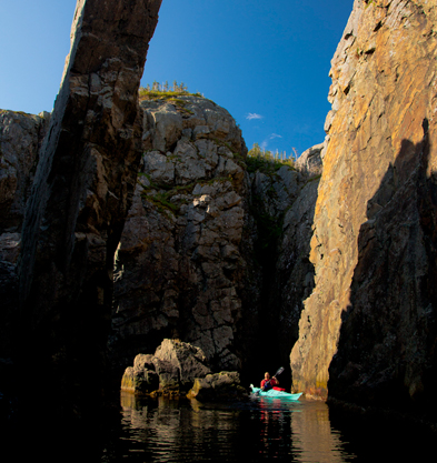
©Parks Canada Agency / Agence Parcs Canada |
Terra Nova National Park of Canada
Headquarters: Glovertown, Newfoundland and Labrador
Remnants of the Eastern Newfoundland Ancient Appalachian Mountains.
Terra Nova National Park of Canada is a place where long fingers of the
North Atlantic Ocean touch the island boreal forest of Eastern
Newfoundland. Rocky headlands provide shelter from the awesome power of
the open ocean. The landscape of the park varies from the rugged cliffs
and sheltered inlets of the coastal region to the rolling forested
hills, bogs and ponds of the inland. Cultural history abounds in the
remnants of sawmills and past human cultures.
|
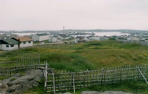
©Parks Canada Agency / Agence Parcs Canada, Rhona Goodspeed, 2001 |
Tilting National Historic Site of Canada
Tilting, Newfoundland and Labrador
Tilting National Historic Site of Canada is an outport landscape created
by a coastal fishing community on the east coast of Fogo Island in Notre
Dame Bay on Newfoundland's northeast coast. The site includes small
wooden vernacular dwellings and outbuildings as well as more modern
structures scattered on the rocky island landscape, surrounded by
gardens, pathways, the shoreline and the harbour. It is a continuing
cultural landscape that encompasses natural, built and living places
that together depict traditional outport life.
An outport community that began to take shape in the 1730s, Tilting is a
small community whose residents have long been dependent upon animal
husbandry, farming and fishing. The designated site comprises landscape,
shoreline, harbour, ponds, small island, one summer trail and portions
of two others, portions of slide paths, three cemeteries, gardens,
fences, buildings including a church, parish hall, former school, post
office, two stores, houses, and a range of outbuildings including
fishing buildings, stables, barns, one milk shed, haysheds and root
cellars.
The heritage value of Tilting resides in the ability of the cultural
landscape to illustrate the outport way of life. Value lies in the
nature, diversity and range of the individual resources within its
cultural landscape, their complex interrelationships, and the clarity
with which their composition, forms and settings reflect the community's
Irish roots and on-going evolution.
|

©Parks Canada Agency / Agence Parcs Canada |
Torngat Mountains National Park of Canada
Headquarters: Nain, Newfoundland and Labrador and Kangiqsualujjuaq, Québec
The spectacular wilderness of this National Park comprises 9,700
km2 of the Northern Labrador Mountains natural
region.
From the Inuktitut word Torngait, meaning "place of spirits," the
Torngat Mountains have been home to Inuit and their predecessors for
thousands of years. The spectacular wilderness of this National Park
comprises 9,700 km2 of the Northern Labrador Mountains natural region.
The park extends from Saglek Fjord in the south, including all islands
and islets, to the very northern tip of Labrador; and from the
provincial boundary with Québec in the west, to the iceberg-choked
waters of the Labrador Sea in the east. The mountain peaks along the
border with Quebec are the highest in mainland Canada east of the
Rockies, and are dotted with remnant glaciers. Polar bears hunt seals
along the coast, and both the Torngat Mountains and George River caribou
herds cross paths as they migrate to and from their calving grounds.
Today, Inuit continue to use this area for hunting, fishing, and
travelling throughout the year.
|
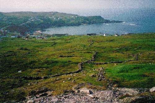
©Parks Canada Agency / Agence Parcs Canada |
Walled Landscape of Grates Cove National Historic Site of Canada
Grates Cove, Newfoundland and Labrador
The Walled Landscape of Grates Cove National Historic Site of Canada is
a visually distinct, grassy landscape of approximately 150 acres (60.7
hectares), situated on the windswept headland of the Northern point of
Avalon Peninsula in Newfoundland. Across the treeless landscape, jagged
stone walls snake over the contours of the land, defining small fertile
gardens and creating a landscape representing the relationship between
the land and the residents of Grates Cove.
In a context where people made their living primarily from the
fisheries, the residents of Grates Cove developed a fluid relationship
with the land, cultivating small garden plots to supplement their diets.
Rocks were removed from pockets of arable soil and stacked around these
pockets to protect them from wind and foraging animals. Gardens nearer
the houses were generally devoted to root crops and those farther away
to pasturage. The system of shared ownership and informal transfer of
land owes its origins to Ireland, the native land of many of the
original settlers.
|
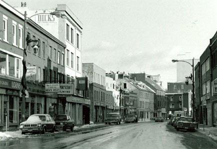
©Parks Canada Agency / Agence Parcs Canada, J. Harris, 1986 |
Water Street Historic District National Historic Site of Canada
St. John's, Newfoundland and Labrador
This district comprises some twenty neighbouring former mid-19th-century
mercantile buildings on either side of Water Street between Beck's Cove
and Mahon's Lane, near the St. John's harbour.
Water Street Historic District was designated a national historic site
of Canada because it is a contiguous group of commercial structures that
are, for the most part, representative of the mercantile establishments
built in St. Johns in the mid 19th century, by those associated with the
Newfoundland fisheries and the Atlantic trade.
Erected (with two exceptions) soon after the Great Fire of 1846, the
buildings represent the commercial architecture in St. John's before the
20th century. Their site and setting is also part of their heritage
value, illustrating their historical access to the harbour.
|
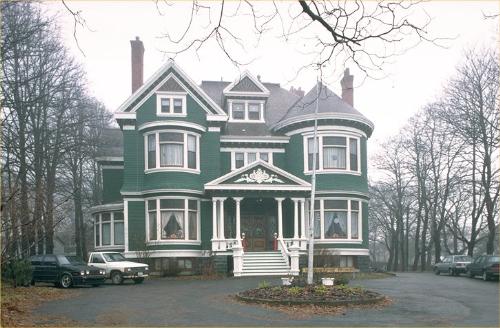
©Parks Canada Agency / Agence Parcs Canada, 1984 |
Winterholme National Historic Site of Canada
St. John's, Newfoundland and Labrador
Winterholme National Historic Site is a large, Queen Anne Revival-style
residence located on a landscaped urban lot at 79 Rennie's Mill Road in
the Rennie's Mill Road Historic District of St. John's.
Winterholme was designated a national historic site in 1991 because it
is a fine example of the conservative approach to the Queen Anne Revival
Style in Canadian domestic architecture.
Its heritage value resides in the physical attributes illustrating a
conservative example of the eclectic, picturesque Queen Anne Revival
style, typical of grand homes in late nineteenth-century Atlantic
Canada.
Winterholme was built by the Horwood Lumber Company in 1905-1907 as a
residence for Sir Marmaduke Winter (1857-1936).
|
|