|
Park Summaries
Northwest Territories
All text and photos are copyrighted by Parks Canada or the Canadian Register of Historic Places
(except as noted) and were extracted from either the Parks
Canada or Canada's Historic Places
Websites. Parks with a grey background are managed by Parks Canada.
©Parks Canada Agency / Agence Parcs Canada |
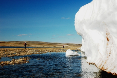
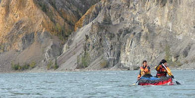
Aulavik National Park of Canada
Headquarters: Inuvik, Northwest Territories and Sachs Harbour, Northwest Territories
Over 12,000 km2 of arctic wilderness on Banks Island.
Aulavik, meaning "place where people travel" in Inuvialuktun, protects
more than 12,000 square kilometres of arctic lowlands on the north end
of Banks Island. The park encompasses a variety of landscapes from
fertile river valleys to polar deserts, buttes and badlands, rolling
hills, and bold seacoasts. At the heart of Aulavik is the Thomsen River,
which offers visitors a chance to paddle one of the continent's most
northerly navigable waterways. This pristine arctic environment is home
to both the endangered Peary caribou and to the highest density of
muskoxen in the world. The wildlife and land have supported aboriginal
peoples for more than 3,400 years, from Pre-Dorset cultures to
contemporary Inuvialuit.
|

©Parks Canada Agency / Agence Parcs Canada, 1980 |
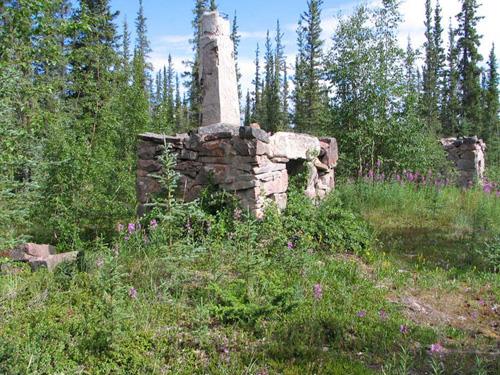
Church of Our Lady of Good Hope National Historic Site of Canada
Fort Good Hope, Northwest Territories
The Church of Our Lady of Good Hope is a small (45 feet by 20 feet),
single story, wooden church, built in the late nineteenth century. It
sits on a bluff above the Mackenzie River in the community of Fort Good
Hope. The church is remarkable for its interior painted
decoration.
The Church of Our Lady of Good Hope was designated a national historic
site in 1977 as an example of a mission church in the Gothic Revival
Style.
The heritage value of this site resides in its illustration of northern
mission churches in a simplified version of the Gothic Revival Style and
in its interior decoration.
Begun in 1865 and largely completed by 1885, this building influenced
the design of later Oblate mission churches in western Canada. It is one
of the oldest surviving buildings of this type and its design,
particularly the interior detail, offers a fine and unique example of
church decoration in the northwest. The building is further
distinguished by its association with Father Émile Petitot, renowned
ethnologist, linguist and geographer of the Canadian northwest, who
lived at the mission from 1864 until 1878 and was responsible for the
design and the partial execution of the building's interior
decoration.
|
|
Déline Fishery / Franklin's Fort National Historic Site of Canada
Deline, Northwest Territories
Déline Fishery / Franklin's Fort National Historic Site of Canada is
situated on the western shore of Great Bear Lake in the Mackenzie River
drainage basin 550 kilometres northwest of Yellowknife in the North West
Territories. Now located within the small community of Déline, the fort
was constructed on the site of a traditional seasonal Déline fishery at
the headwaters of the Bear River. This was the wintering site for a
group headed by Sir John Franklin, who, starting in 1825, mapped part of
the Arctic coast of Canada. The fort provided a staging area and winter
quarters for two years, from 1825 to 1827, during his second overland
expedition. There are no known above ground remains.
Constructed to provide a wintering place for nearly 50 people in Sir
John Franklin's second overland expedition from 1825 to 1827, Fort
Franklin was sited to take advantage of a highly productive Aboriginal
fishery. Factor Peter Warren Dease of the Hudson's Bay Company selected
one of the most productive Déné fisheries in the Mackenzie River
drainage area, parts of which remain ice free, as the location of the
Fort. Historic prints of Fort Franklin show a cluster of small
structures including a small tower. During 1820's the Hudson Bay Company
re-opened its store in order to supply Franklin's expeditions. The
second expedition came into close contact with the Dogrib who wintered
there, and with the Hare-Slavey and Gwich'in who journeyed from along
the north shore of Sahtu to trade meat and furs. Great Bear Lake and
Great Bear River became important trade routes. The Sahtu Déné supplied
the post with food and guided the mapmakers during their stay from 1825
to 1827.The trade for meat and fish with the Déné of Great Bear Lake was
crucial to the expedition's food supply and survival. This exchange
enabled the expedition to avoid the supply difficulties faced during the
first expedition. Dr. Richardson a Naval surgeon provided the local
population with medical care in exchange for supplies and aid.
The discovery of pitchblende at Port Radium and oil at Norman Wells
encouraged growth around the site at Fort Franklin in the 1920s, and
further development occurred in the 1940s and 1950s when a period of
construction centred on the Roman Catholic Mission, the Federal Day
School and the post of the Hudson Bay Company. The community become a
permanent settlement in 1952. In 1993, Fort Franklin officially changed
its name to Déline, which is now largely inhabited by people of the Déné
and Métis communities. The present-day community of Déline has had a
long-standing interest in Old Fort Franklin and in the site's power to
explain its own past.
|

©Culture and Communications, Government of the Northwest Territories, A Promise Fulfilled: The Visit of Pope John Paul II (Yellowknife: Government of the Northwest Territories, 1989), 59 |
Ehdaa National Historic Site of Canada
Fort Simpson, Northwest Territories
Ehdaa National Historic Site of Canada is the traditional Dene meeting
place on the flats at the southwestern end of Fort Simpson Island that
contains facilities built for the 1987 visit of Pope John Paul
II.
The heritage value of Ehdaa National Historic Site of Canada is
reflected in the landscape features that support its traditional role as
a seasonal gathering place for the Liidlii Kue Dene, including its
easily reached central location and relics of Pope John Paul II's 1987
visit which represent a recent use of the site in its traditional role
that is significant in repairing the wholeness of Dene culture and its
history.
|

©Parks Canada Agency / Agence Parcs Canada |
Fort McPherson National Historic Site of Canada
Fort McPherson, Northwest Territories
Fort McPherson National Historic Site of Canada is located in a hamlet
at the centre of the Peel River / Mackenzie Delta region of the
Northwest Territories, just off the Dempster Highway. The site consists
of the site of the Hudson's Bay Company trading post as it was in the
19th and early 20th centuries, including an Anglican and a Roman
Catholic mission and the post of the Royal North-West Mounted Police.
Official recognition refers to the boundaries of the community of Fort
McPherson as it was mapped in 1898.
According to oral tradition, the Gwich'in ("people of the head waters")
population has been present on the Mackenzie Delta for over 20,000
years, where they survived by hunting, fishing and trapping. In 1840,
the Hudson's Bay Company established Fort McPherson, the first trading
post north of the Arctic Circle, six kilometres upriver from traditional
Teetl'it Gwich'in lands, and Chii tsal dik Hill, to trade meat and furs
with the Gwich'in and Inuit. Fort McPherson was moved to its current
location in 1848 and was the principal trading post in the Mackenzie
Delta region for over 50 years. The settlement that grew around the fort
became a centre of Roman Catholic and Anglican missionary activity after
1860, and the site of the Western Arctic's first North West Mounted
Police post in 1903. By the 1930s much of the fort's former importance
had passed to newer settlements such as Aklavik. Fort McPherson is now
the largest Gwich'in settlement in the Northwest Territories.
|
©Government of Canada / Gouvernement du Canada, D. Mulders, 2007 |
Fort Reliance National Historic Site of Canada
Great Slave Lake, Northwest Territories
Fort Reliance National Historic Site of Canada is located at the eastern
end of Great Slave Lake, near the mouth of the Lockhart River in the
Northwest Territories. The fort, built as a wintering site in the early
19th century, is set back from the shoreline, on a raised green terrace.
Found within the site are the remains of four fireplaces and chimneys,
as well as traces of foundations from cabins, piles of rubble, and other
shallow pits and mounds resulting from the occupation of the
site.
Fort Reliance was built by Alexander Roderick McLeod of the Hudson's Bay
Company in 1833 on the easternmost edge of Great Slave Lake. Its
original purpose was to serve as a base of operations for an expedition
led by Captain George Back, R.N., who was charged with locating Captain
(later Sir) John Ross after he failed to return from his 1829 Arctic
voyage. Captain Back wintered at the fort between 1833-1835 and from
this base explored much of the Thelon and Great Fish Rivers during the
summers. The fort was abandoned in 1835 when the expedition ended, but
was rebuilt and operated as a Hudson's Bay Company post for a brief
period in the 1850s. The remains of the four stone fireplaces with their
wattle and daub chimneys are unique relics of the history of exploration
and commerce in Canada's north.
|

©Parks Canada Agency / Agence Parcs Canada, 1907 |
Fort Resolution National Historic Site of Canada
Fort Resolution, Northwest Territories
Fort Resolution National Historic Site of Canada is located in the
community of Fort Resolution, on the southeastern shore of Great Slave
Lake in the Northwest Territories. The site is a small,
rectangular-shaped peninsula on which stood the fur post and
subsequently a Hudson's Bay Company store during the early 20th century.
There are no visible remains of the original fort. Official recognition
refers to the irregular 8.8-hectare footprint of the Hudson's Bay
Company post as it stood in 1895.
The first fur trade posts on Great Slave Lake were established at the
end of the 18th century by Cuthbert Grant Sr. of the North West Company
and his rival Laurent Leroux of the "Little Company". These included
Grant's Slave Fort, which was twice moved westward, finally settling
near the mouth of the Slave River in 1791. This post remained largely
unchallenged by competing traders until, in 1819, Aualay McAulay of the
Hudson's Bay Company built a competing post nearby, which he named Fort
Resolution. After the union of the two companies in 1821 the two forts
were merged, and were moved to a small peninsula facing the Resolution
Islands. Fort Resolution became the Hudson's Bay Company's principal
post on the lake, and remains an active community.
|
|
Fort Simpson National Historic Site of Canada
Fort Simpson, Northwest Territories
The junction of the Liard and Mackenzie Rivers has always been important
in the spiritual life of the Dene. This meeting place became a focus for
the fur trade in the Deh Cho Region. In 1804 the North West Company
built Fort of the Forks nearby; the Hudson's Bay Company built Fort
Simpson in 1822. Dene people from the Liard and Mackenzie valleys, the
mountains to the west, and Lac La Martre traded here regularly. Their
descendants make up the present Dene and Métis population. Pope John
Paul II's visit here in 1987 celebrated the continued spiritual
significance of the rivers' junction.
|

©Hay River Dene Band / Bande des Dénés de Hay River, 1991 |
Hay River Mission Sites National Historic Site of Canada
Hay River Reserve, Northwest Territories
Hay River Mission Sites National Historic Site of Canada is situated on
the old Dene village site within the Hay River Dene Reserve on the east
side of the community of Hay River, which is itself at the head of
navigation of the Mackenzie River of the Northwest Territories.
Established in the late 19th century, the site consists of St. Peter's
Anglican Church, Ste. Anne's Roman Catholic Church, remains of a
rectory, and associated cemeteries containing spirit houses. These
missions are situated on either side of the site of the old Dene village
proper. Official recognition refers to the individual buildings and
their associated landscapes.
In 1868, an Oblate Mission and a Hudson's Bay Company fur trading post
were established at Hay River. The trading post closed in 1878. A small
group of Slavey people led by Chief Chiatlo settled permanently at the
location around 1890. Thomas Jabez Marsh established an Anglican mission
in 1893, that worked alongside the Roman Catholic mission. By 1909,
Marsh and his successor A.J. Vale had completed St. Peter's Church,
which eventually included a large school. Around 1900, once the missions
were established, they were located approximately at the centre of a
4000 kilometre inland water route that extended north of Edmonton from
Athabaska Landing to the Arctic Ocean. This route was the main means by
which the western Northwest Territories were opened up to Euro-Canadian
influence and development. This meeting of cultures between the local
Dene and the two churches have shaped this northern community. The
heritage value of Hay River Mission Sites National Historic Site of
Canada lies in the physical integrity of the extant buildings and
cemetery features as a whole, including the spirit houses, together
forming a cultural landscape, in their symbolic importance and in their
spatial inter-relationships.
|
©Library and Archives Canada/Bibliothèque et Archives Canada, Department of Indian and Northern Affairs/Ministère d'Affaires indiennes et du Nord Canada, 1932 |
Kittigazuit Archaeological Sites National Historic Site of Canada
Inuvik Region, Northwest Territories
Kittigazuit Archaeological Sites National Historic Site of Canada is
located on the island of Kittigazuit at the mouth of the Mackenzie River
in the Northwest Territories. The site, set in and around the
present-day village of Kitigaaryuk, encompasses a number of
archaeological features, including the ruins of winter houses, a
collapsed log cabin and ice house and remains from the old village of
Kittigazuit. On the high ground to the north and south of the village, a
number of traditional graves are visible by their marker stones.
The heritage value of Kittigazuit Archaeological Sites lies in its
historical associations with the Inuit populations who used the site for
beluga whale hunting, as illustrated by the site and its archaeological
remains. Archaeological evidence shows that the Kittegaryumiut have
occupied Kittigazuit continuously for over 500 years, between 1400 and
1900. The site was used for summer beluga whale hunting by Inuvialuit
populations living in the area, who took advantage of the estuary as a
natural trap for the whales. Approximately 1000 people used Kittigazuit
and the neighbouring village of Kupuk during the summer months, making
it the largest traditional Inuit community known in Arctic Canada.
Remains of six large winter houses and the number of traditional
aboriginal graves are still visible today. The site is also the place
where Sir John Richardson, a member of Sir John Franklin's second Arctic
expedition, first met the Inuit. Additionally, it was the location of
the first Hudson's Bay Company trading post operated on the western
Arctic coast. The remains of a log house and ice house used by the
Hudson's Bay Company are still visible.
|
©Parks Canada Agency / Agence Parcs Canada |
Nááts'ihch'oh National Park Reserve
Headquarters: Tulita, Northwest Territories
Measuring 4,850 square kilometres, Nááts'ihch'oh National Park Reserve
adjoins Nahanni National Park Reserve and it touches the Yukon boundary
to the West.
Nááts'ihch'oh National Park Reserve is named after Nááts'ihch'oh the
mountain — a powerful place for the people of the Sahtu. Near the
Yukon-Northwest Territories border, the park is in the traditional lands
of the Shútagot'ine (Mountain Dene), and home to grizzly bear, Dall's
sheep, mountain goats, and woodland caribou.
|

©Parks Canada Agency / Agence Parcs Canada |
Nagwichoonjik (Mackenzie River) National Historic Site of Canada
Tsiigehtchic, Northwest Territories
Nagwichoonjik (Mackenzie River) National Historic Site of Canada is the
cultural landscape along the section of the Mackenzie River that
traverses the traditional homelands of the Gwichya Gwich'in of
Tsiigehtchic (formerly Arctic Red River). This historic place extends
from Thunder River on the southeast boundary of their country to Point
Separation in the Mackenzie Delta, a 175-kilometer section of the
river.
The heritage value of Nagwichoonjik (Mackenzie River) is reflected in
the cultural landscape along the river that reflects the river's role as
a principal repository of the stories (oral histories) that suffuse with
meaning the history of the landscape as the Gwichya Gwich'in know it.
The traditional lifestyle of the Gwichya Gwich'in has been shaped by
their close connection with the land and the river, and many points
along the river play an essential role in the transmission and survival
of Gwich'in culture. Nagwichoonjik represents the complex sets of
relationships between the Gwich'in people, their traditional lands and
their past, before and after the arrival of the European
explorers.
|
©Parks Canada Agency / Agence Parcs Canada |
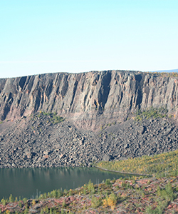
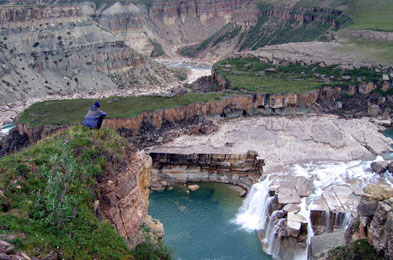
Nahanni National Park Reserve of Canada
Headquarters: Fort Simpson, Northwest Territories
Northwest Territories' UNESCO World Heritage Site.
Nahanni National Park Reserve of Canada protects a portion of the
Mackenzie Mountains Natural Region offering the adventurous visitor a
wilderness experience. A key feature of the park is the Naha Dehé (South
Nahanni River). Four great canyons line this spectacular whitewater
river. At Nailicho (Virginia Falls) the river plunges in a thunderous
plume. The park's sulphur hotsprings, alpine tundra, mountain ranges,
and forests of spruce and aspen are home to many species of birds, fish
and mammals. A visitor centre in Fort Simpson features displays on the
history, culture and geography of the area. The park was inscribed on
UNESCO's World Heritage List in 1978.
|
©Parks Canada Agency / Agence Parcs Canada, 1976 |
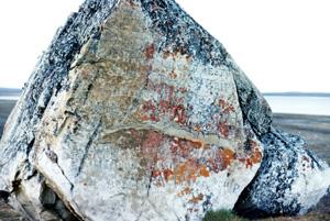
Parry's Rock Wintering Site National Historic Site of Canada
Melville Island, Northwest Territories
Parry's Rock is a large sandstone rock, approximately 5.5 metres long
and 3 metres high, located at Winter Harbour, Melville Island, N.W.T.
(latitude 74°46'00" N, longitude 110°38'00" W). The top of the rock is
52 feet above sea level. The rock contains a number of carvings and a
plaque mounted in 1909.
Parry's 1819 expedition arrived in the area in mid-September and spent
the winter in Winter Harbour. Before leaving the area, the ship's
surgeon, J. Fisher, inscribed the names of the two vessels, Hecla and
Griper, and their captains on the large sandstone rock located on the
beach. Parry continued on, sailing farther west, but was stopped by ice
near Cape Dundas. Had he been able to sail on through the McClure Strait
he would have entered the Beaufort Sea and been able to pass through the
Bering Strait to the Pacific. Parry's expedition had demonstrated that
Lancaster Sound opened a passage towards the west that later
explorations would show was the Northwest Passage.
|
©Parks Canada Agency / Agence Parcs Canada |
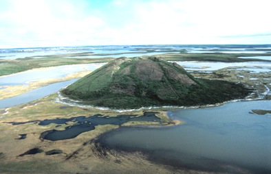
Pingo Canadian Landmark
Inuvik, Northwest Territories
Pingo Canadian Landmark protects a unique arctic landform: ice-cored
hills called pingos. Rising out of the flat tundra, these hills provide
a distinctive backdrop to the community of Tuktoyaktuk, Northwest
Territories. Pingo Canadian Landmark features eight of the 1350 pingos
found in the region including Ibyuk Pingo, Canada's highest. Reaching 49
metres (160 feet) in height and stretching 300 metres (984 feet) across
its base, Ibyuk is also the world's second-tallest pingo.
For centuries, pingos have acted as navigational aides for Inuvialuit
travelling by land and water and as a convenient height of land for
spotting caribou on the tundra or whales offshore.
|

©Parks Canada Agency / Agence Parcs Canada |
Saoyú-Ehdacho National Historic Site of Canada
Grizzly Bear Mountain and Scented Grass Hills, Northwest Territories
Expression of cultural values through the interrelationship between
landscape, oral histories, graves and cultural resources.
Sahoyúé-§ehdacho National Historic Site of Canada, also known as
Sahoyue-Edacho (pronounced saw-you-eh-da-cho), is a large cultural
landscape made up of two peninsulas, located south of the tree line in
the Northwest Territories. The two peninsulas, Sahoyue and Edacho, reach
into Great Bear Lake from the west and south. Both landscapes rise
gradually over a number of kilometres to broad, relatively flat summits
covered with open boreal forest. Official recognition refers to the two
peninsulas, an area of 5,565 square km, and their associated features
and buildings.
Sahoyue-Edacho was designated a national historic site of Canada in 1997
because: its cultural values, expressed through the interrelationship
between the landscape, oral histories, graves and cultural resources,
such as trails and cabins, help to explain and contribute to an
understanding of the origin, spiritual values, lifestyle and land-use of
the Sahtu Dene.
Its heritage value lies in the cultural landscape as a whole, its
environmental quality, which allows traditional lifestyle and land use
activities, and the cultural values of the Sahtu Dene expressed through
the inter-relationship between landscape, oral history, graves and
cultural resources. These are outstanding landscapes that blend the
natural and spiritual worlds of the Sahtu Dene and help define them as a
people. The extensive oral tradition brings the history of the Sahtu
Dene alive and signifies the importance of these sacred lands to them
and to the heritage of Canada.
|
©Parks Canada Agency / Agence Parcs Canada |
Thaidene Nene National Park Reserve of Canada
Headquarters: Yellowknife, Northwest Territories
Located at the eastern end of Great Slave Lake in the Northwest Territories,
Thaidene Nene National Park Reserve is part of a larger group of protected areas
around the East Arm and Artillery Lake regions. Thaidene Nene means 'Land of the
Ancestors' in the Dënesųłiné-or Chipewyan-language. The Łutsël K'e Dene First
Nation (ŁKDFN) consider Thaidene Nene to be the 'heart of the homeland' as well
as a sacred place. The Northwest Territory Métis Nation also has significant
cultural ties to the area. Thaidene Nene is a culturally rich area, including
the traditional and present-day hunting, fishing, gathering and spiritual areas
used by various Indigenous peoples. Many local residents and visitors also use
the Thaidene Nene area for a variety of recreational activities.
Thaidene Nene was first identified as a potential national park in the late
1960's by the Canadian government. In 1970, a land withdrawal of approximately
7,340 km2 was applied to the area with no expiry date. At that time, ŁKDFN did
not support the idea of a national park in their traditional territory so the
proposal was put on hold. In 2000, Chief Felix Lockhart of ŁKDFN approached the
Canadian government to renew discussions about establishing Thaidene Nene as a
national park to protect a portion of their traditional territory from
development. In 2007, a further 26,350 km2 of land was withdrawn bringing the
total study area to 33,690 km2. Following the devolution of land and resources
to the Government of the Northwest Territories (GNWT), work was initiated on
developing a matrix of protected area designations and northern tools for the
33,600 km2 Thaidene Nene land withdrawal area in 2015. Through a series of
meetings with Parks Canada, GNWT, ŁKDFN, Northwest Territory Métis Nation and
other Indigenous groups, it was agreed that a proposal for a national park
reserve of 14,000 km2 would be part of that matrix.
Thaidene Nene's spectacular wilderness characteristics attract many visitors and
local residents each year for experiences such as: boating, camping, fishing,
berry picking and hiking in 'the land of giants.' There are numerous adventures
just waiting to be had like: exploring Fort Reliance National Historic Site /
Old Fort Reliance Territorial Historic Site at the mouth of the Lockhart River;
hiking up to Tyrrell Falls and learning about the traditional village site known
as Kaché with Łutsël K'e Dene First Nation's Ni hat'ni Dene Watchers of the Land
Program; boating through The Gap into Wildbread Bay; and fishing in Christie
Bay, the deepest fresh water body in North America, home of huge lake
trout.
|
©Parks Canada Agency / Agence Parcs Canada |
Tuktut Nogait National Park of Canada
Headquarters: Inuvik, Northwest Territories and Paulatuk, Northwest Territories
Calving ground for the Bluenose caribou herd.
With rolling tundra, wild rivers, precipitous canyons, and a variety of
unique wildlife and vegetation, Tuktut Nogait ('young caribou') is one
of Canada's undiscovered gems. This remote park is located 170
kilometres north of the arctic circle and is home to the Bluenose West
caribou herd, wolves, grizzly bears, muskoxen, arctic char, and a high
density of raptors. The wildlife and land have supported aboriginal
peoples for thousands of years, from the Copper and Thule cultures to
contemporary Inuvialuit.
|
©Parks Canada Agency / Agence Parcs Canada |
Wood Buffalo National Park of Canada
Headquarters: Fort Smith, Northwest Territories and Fort Chipewyan, Alberta
UNESCO World Heritage Site larger than Switzerland.
As part of Canada's system of national parks and national historic
sites, Wood Buffalo National Park of Canada is our country's largest
national park and one of the largest in the world. It was established in
1922 to protect the last remaining herds of bison in northern Canada.
Today, it protects an outstanding and representative example of Canada's
Northern Boreal Plains.
|
|