|
Park Summaries
Manitoba
All text and photos are copyrighted by Parks Canada or the Canadian Register of Historic Places
(except as noted) and were extracted from either the Parks
Canada or Canada's Historic Places
Websites. Parks with a grey background are managed by Parks Canada.

©Parks Canada Agency / Agence Parcs Canada, 1965 |
Battle of Seven Oaks National Historic Site of Canada
Winnipeg, Manitoba
The Battle of Seven Oaks National Historic Site of Canada is located in
the urban setting of Winnipeg Manitoba, at the intersection of Main
Street and Rupert's Land Boulevard. The Battle of Seven Oaks occured
near this location, on June 19 1816, between a group of Métis and a
group of Red River Settlers. There are no known extant remains of the
battle; however, in 1951, a plaque was put by the Historic Sites and
Monuments Board of Canada on the monument erected by the Manitoba
Historical Society near the 1816 site.
The Battle of Seven Oaks took place on June 19, 1816 north of the forks
of the Red and the Assiniboine Rivers. It was a violent encounter
between a party of Métis led by Cuthbert Grant and a group of Hudson's
Bay Company men and Selkirk settlers led by Governor Robert Semple. This
battle was the culmination of a conflict between the Montréal-based
North West Company and the London-based Hudson's Bay Company, for
control of the fur trade in the Northwest. Furthering the conflict was
Lord Selkirk's attempt to establish an agricultural colony at Red River,
which the Métis saw as a threat to their traditional way of life. The
battle began after negotiations over the pemmican supply failed,
resulting in the deaths of Semple and 20 of his men. Grant, having
suffered only one casualty, went on to take Fort Douglas and to expel
the settlers from the region. Although the opposing companies would
eventually merge, this event helped create a national consciousness for
the Métis.
|

©Stephen Hayter, Commonwealth Air Training Plan Museum, Inc., 1999 |
BCATP Hangar No. 1 National Historic Site of Canada
Brandon, Manitoba
BCATP Hangar No. 1 is a Second World War airplane storage and
maintenance hangar located on the airfield at Brandon Municipal Airport.
It is a monumental green flat-roofed cube with an immense central
sliding door on its façade, and industrial-size multi-paned windows
above low shed wings to each side.
The heritage value of BCATP Hangar No. 1 resides in its association with
the BCATP as a purpose-built type of structure, and in the continued
integrity of its design, function, materials, technology, site, and
setting as a representation of the "double landplane hangar." BCATP
Hangar No. 1 is a "double landplane hangar" designed by the Construction
Engineering Branch of the Royal Canadian Air Force during World War II.
It was built in 1940-41 as the first of 701 standard plan hangars (of
minimally varying sizes, configurations and materials), constructed
under the BCATP to support the training of aircrews from Canada and the
Commonwealth. It has been refurbished since 1987 to repair its roofs,
truss system, and east side windows, and today houses the BCATP Museum
at Brandon Airport.
|
©Parks Canada / Jeffrey Thorsteinson |
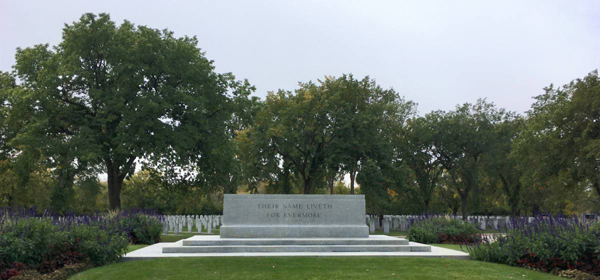
Brookside Cemetery National Historic Site of Canada
Winnipeg, Manitoba
Brookside Cemetery in Winnipeg is among the oldest and largest examples
of the garden cemetery tradition in Western Canada. Established in 1878,
it is located on Treaty 1 territory and the homeland of the Métis
Nation. The cemetery, which is approximately 70 hectares in size, was
planned and executed on the prairie landscape. It illustrates many
characteristics of the Euro-American garden cemetery style, including
winding roads, irregularly shaped islets, a waterway, and park-like
landscape design. It also features a range of plantings and assorted
funerary monuments of artistic interest. Brookside Cemetery also hosts
one of Canada's largest Fields of Honour, an area which illustrates
military cemetery traditions. The form and development of the cemetery
exemplify the late 19th and early 20th century concern in Canada for
civic beauty and the provision of public greenspace in cities.
Brookside Cemetery was first laid out between 1877 and 1883 in the
garden (or rural) cemetery style by English-born surveyor and architect
Thomas H. Parr. However, the transformation of the open prairie
landscape into a site which exemplified this picturesque approach to
landscape design truly gained momentum in 1896 when the cemetery was
transferred to Winnipeg's recently founded Public Parks Board. This
group envisioned a place where all classes could escape the crowds and
noise of the city in locations designed to appear like "pleasing rural
scenery." Between 1899 and 1904, David D. England, the first
Superintendent of Winnipeg's Public Parks Board, altered and enlarged
Parr's plans and directed the planting of thousands of trees at
Brookside. The succeeding Superintendent of Parks, George Champion,
added a pond and a bridge, planted additional trees, and developed the
northern part of the site in keeping with the garden cemetery style.
In the early 20th century, the northern portion of Brookside Cemetery
came to serve as a military Field of Honour. Particularly significant is
the First World War-era section of the Field of Honour which displays a
unique military cemetery design that predates the standardized approach
of the Commonwealth War Graves Commission (CWGC). This area exemplifies
the efforts of local service groups to honour fallen soldiers. The heart
of the Field of Honour is an islet known as the "Tear Drop," wherein
graves are arrayed in the form of a tear. In 1922, a CWGC Cross of
Sacrifice was installed at the centre of the Tear Drop. Outside of this
section, CWGC's standard axial layout was adopted, and in 1960, a CWGC
Stone of Remembrance was added. The only one of its kind in the country,
the Stone commemorates all Commonwealth sailors, soldiers and airmen
buried in Canada. Its placement was chosen for the symbolic fact of the
cemetery's location near the centre of the country.
A number of other important monuments and historic elements are located
throughout Brookside Cemetery. These include early 20th-century Manitoba
limestone and wrought-iron entry gates, a Korean Veterans Cairn, a Hong
Kong Veterans Cairn, a monument to the victims of the 1947 Dugald train
disaster, the Winnipeg Fire Fighters Memorial Monument, and the
University of Manitoba Medical Monument.
|
|
Brockinton National Historic Site of Canada
Melita, Manitoba
Brockinton National Historic Site of Canada is a stratified
archaeological site located on the east bank of the Souris River, near
Melita, Manitoba. Located on a steep slope between the flood plain and
the prairie the site consists of a thin crescent-shaped strip of
low-lying land that has yielded evidence of three distinct periods of
occupation, dating from 800 to 1650 A.D. The landward side of the site
is wooded. The site includes remains of a bison drive, remains from the
Duck Bay cultural tradition, and also traces of occupation from an
unidentified Plains people.
Brockinton is a multi-component archaeological site that includes three
main layers of occupation dating to the Late Pre-Contact Period from 800
to 1650 A.D. The oldest level, dating from c.800 A.D., contains the
remains of an abandoned bison drive. This level contains an astonishing
number of bones and tools, including a large quantity of small Prairie
side-notched arrowheads. The second layer, dating from 1100 to 1300
A.D., was home to the Duck Bay culture, a regional variant of the
Blackduck complex found in northern Ontario. This tradition is not
usually found on the plains, but rather has a widespread distribution in
the wooded portion of south-eastern Manitoba and the adjacent regions of
Minnesota. The uppermost level, dating from c.1650 A.D., contains
evidence of an unidentified Plains people from the Dakotas. This appears
to be the only occurrence of these peoples in Canada, who are
represented by a uniquely decorated, rich and varied ceramic
assemblage.
|

©Parks Canada Agency / Agence Parcs Canada, Grant Tyler, 1993 |
Camp Hughes National Historic Site of Canada
North Cypress, Manitoba
Camp Hughes National Historic Site of Canada is located south of the
Trans-Canada Highway 10 kilometres west of Carberry, Manitoba. Formerly
a First World War military training camp, it is one of the most intact
simulated battlefield terrains in Canada. The site consists of rolling
open grassy fields, remnants of the military camp consisting of
administration and training areas, a cemetery and archaeological
vestiges.
The heritage value of Camp Hughes lies in its physical fabric and
historical associations. It was at this camp that tens of thousands of
Canadian soldiers received instruction in the tactics and weaponry of
war prior to being deployed to Europe during the First World War.
Battlefield conditions, including a system of trenches, grenade pits,
and a rifle range, were created to reflect the realities of trench
warfare. Many of the soldiers who trained at Camp Hughes went on to
fight at Vimy and Passchendaele, defining battles in Canada's history.
The camp served as a military training facility until 1934 when it was
dismantled as part of an unemployment relief project.
|
©Former Canadian Pacific Railway Station, Sean Marshall, 2003 |
Canadian Pacific Railway Station National Historic Site of Canada
Winnipeg, Manitoba
Winnipeg Railway Station National Historic Site of Canada is the former
Canadian Pacific Railway Station situated at 181 Higgins Avenue,
Winnipeg. It is a grand, four-storey Beaux-Arts building of contrasting
red brick and Tyndall limestone detailing.
The heritage value of Winnipeg (Canadian Pacific) Railway Station
National Historic Site lies in impact as a grand 20th century urban
railway station. It is embodied in the Winnipeg station's Beaux-Arts
style, its monumental proportions, its efficient and expansive interior,
fine materials and workmanship. It is also reflected in the building's
layout and siting.
This was the fourth railway station constructed by Canadian Pacific
Railway in Winnipeg. It was built in 1904-06 as part of a monumental
three part complex which included a luxury hotel, the station and an
administrative wing arranged in a U-shaped configuration. Designed by
Montreal architects W.S. and E. Maxwell, the station was the first
Beaux-Arts building constructed in Canada. Its facilities were expanded
in 1915 to include six additional main lines, elevation of the road bed,
a larger second-class waiting room and baggage handling facilities. This
building continued to operate as a railway station until 1978, and
Canadian Pacific still uses its administrative wing although the Royal
Alexandra Hotel associated with the complex was demolished in
1971.
|

©Parks Canada Agency / Agence Parcs Canada |
Churchill Rocket Research Range National Historic Site of Canada
Churchill, Manitoba
Churchill Rocket Research Range National Historic Site of Canada is
located on the 59th parallel, a few kilometres east of the town of
Churchill, Manitoba, on the shores of Hudson Bay. The installation is an
immense wedge-shaped piece of land with facilities for launching,
tracking and retrieving the rockets. Until the site closed in 1985, the
area known as the range head provided the working base for launching and
tracking rockets for research into the upper atmosphere.
The heritage value of Churchill Rocket Research Range lies in the
completeness with which the cultural landscape of its range head
portrays the nature and technology of Cold War rocket research in
Canada. Value resides in the range head's design, composition,
functional disposition, scientific and technological equipment, site and
setting, as well as those of its component buildings and structures.
Churchill Rocket Research Range was built by the United States Army
under the aegis of Canada's Defence Research Board in 1956. It launched
its first rocket for research into the upper atmosphere in October 1956.
Over the years, Canadian programs participated increasingly in rocket
research at this centre, and it became a National Research Council of
Canada (NRC) facility in 1964. This was the only facility in Canada for
launching sounding rockets. The Black Brant rocket, designed and built
in Canada, was first launched from this centre in 1959.
|
©Arch. J. Wilson Gray, 1912 |
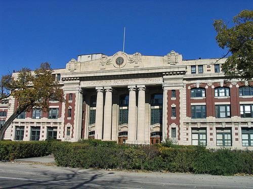
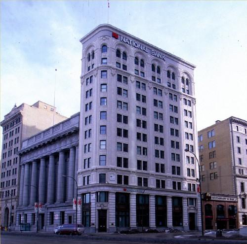
Confederation Building National Historic Site of Canada
Winnipeg, Manitoba
The Confederation Building, Winnipeg is a 10-storey skyscraper, built in
1912. It is located on Main Street in the heart of the early business
district of the City of Winnipeg.
The Confederation Building was designated a national historic site of
Canada in 1976 because it is a good example of an early
Sullivan-inspired skyscraper.
Designed by Toronto architect J. Wilson Grey as provincial headquarters
for the Confederation Life Association, this building exhibits the
influence of Louis Sullivan of the Chicago School of Architecture. In
keeping with the Chicago School, the building's facade truthfully
reflects both its steel-frame construction, and its division into three
functional tiers expressed horizontally.
|

©Parks Canada Agency / Agence Parcs Canada, HRS 1101, 1995 |
Dalnavert National Historic Site of Canada
Winnipeg, Manitoba
Dalnavert National Historic Site is a two-and-a-half-storey,
late-19th-century, red-brick house with a large wooden verandah. It is
located on a large double lot in a residential neighbourhood in downtown
Winnipeg. A one-storey addition to the rear of the house has been added
to serve as an orientation centre for Dalnavert Museum.
Dalnavert was designated a national historic site in 1990 because it is
a particularly good example of the Queen Anne Revival style, as
expressed in domestic architecture.
Built in 1895 for Sir Hugh John Macdonald and his young family, the
house sits on an expansive double lot. A premier of manitoba from 1899
to 1900, Sir Hugh John Macdonald was the son of sir John A. Macdonald.
Dalnavert typifies the Queen Anne style in its asymmetrical composition,
its use of red brick and contrasting trim, its varied massing and its
eclectic detailing. Its rich interior decoration is also typical of this
style, as is the wrap-around wooden verandah. The compact plan and
relatively simple roofline show the adaptation of the style to a cold
climate.
|

©Parks Canada Agency / Agence Parcs Canada, Fern Graham, 1998 |
Dominion Exhibition Display Building II National Historic Site of Canada
Brandon, Manitoba
The Dominion Exhibition Display Building II is a stately wooden
exhibition building located in the midst of the City of Brandon's
exhibition grounds. The structure's scale, materials and classical
elements proclaim its early 20th-century origins.
Designed by architects Shillinglaw and Marshall, this grand
Beaux-Arts-style building was constructed in 1913 for agricultural
display at the annual Dominion Exhibition, an initiative of the
Department of Agriculture.
|
©Parks Canada Agency / Agence Parcs Canada |
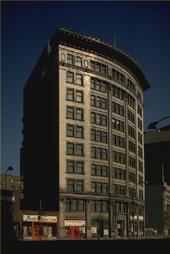
Early Skyscrapers in Winnipeg National Historic Site of Canada
Winnipeg, Manitoba
The Early Skyscrapers in Winnipeg National Historic Site of Canada is a
grouping of three tall commercial buildings (Union Trust Tower, the
Confederation Building, and the Bank of Hamilton) within Winnipeg's
Exchange District National Historic Site of Canada, the historic
business core of the city. They exhibit a variety of stylistic details
but generally conform to the then-prevalent Chicago style for the
incipient skyscrapers appearing in increasingly densely built city
centres.
Their heritage value resides in their impact as a grouping of relatively
tall, monolithic structures whose articulation derives from the new
technological and aesthetic trends emanating from the booming metropolis
of Chicago, Illinois. In the early twentieth century, when these
ten-to-thirteen-storey buildings appeared, they set a new standard for
increasingly dense urban construction.
|
©Parks Canada Agency / Agence Parcs Canada, K. Dahlin, 2003 |
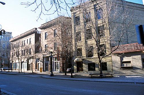
Exchange District National Historic Site of Canada
Winnipeg, Manitoba
Exchange District National Historic Site of Canada is located in
downtown Winnipeg, Manitoba. The site consists of a densely built,
turn-of -the-century warehousing and business centre of some 150
buildings covering 20 city blocks. Most of the district was constructed
from about 1880 to 1913, using the most up-to-date construction methods
and architectural styles. The intact nature of its densely built grid
plan with its many compact, masonry structures of limited height, the
intensive occupation of the urban lots, and the use of relatively
sophisticated turn-of-the-century architectural styles, gives this
district a distinct identity within the surrounding city.
The heritage value, as defined by the above reasons for recognition,
resides in the district's illustration of a densely built,
turn-of-the-century warehousing and business centre utilizing
contemporary construction methods and architectural styles.
|

©Parks Canada Agency / Agence Parcs Canada |
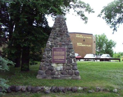
First Homestead in Western Canada National Historic Site of Canada
Portage la Prairie, Manitoba
First Homestead in Western Canada National Historic Site of Canada is
located on a flat parcel of land north of Portage La Prairie near
Oakland, Manitoba. The site consists of the first homestead in western
Canada, established under the Dominion government's new survey system
adopted in 1871. There are no visible remains of the original homestead,
which was first owned by John Sutherland Sanderson. In 1976, the
Historic Sites and Monuments Board of Canada erected a plaque on a grey
tyndall stone block cairn to commemorate the site.
The heritage value of First Homestead in Western Canada resides in its
historical associations with the Dominion Government's Homestead
Regulations in western Canada. Following the adoption of a new survey
system in 1871, the Canadian government inaugurated its homestead policy
under the Dominion Lands Act of 1872. This policy attracted immigrants
from all parts of the world to establish settlements in western Canada.
The first homestead entry in the west was filed by John Sutherland
Sanderson, a Scotsman from the Lothians whose application was filed on
July 2, 1872 and numbered "1".
|

©Historic Resources Branch, Manitoba Culture, Heritage, Tourism and Sport, 2009 |
Former Miami Northern Pacific and Manitoba Railway Station National Historic Site of Canada
Highway 23, Thompson, Manitoba
The former Miami Northern Pacific and Manitoba Railway Station, a
two-storey wooden depot-residence, built in 1889, with an attached
one-storey 1903 freight shed, stands next to a rail right-of-way near
the southern edge of Miami.
The former Miami Northern Pacific and Manitoba Railway Station, of sober
proportions, aesthetics and materials, emphasizing efficiency and
economy, is the oldest intact rail station in Manitoba situated in its
original setting. The stout wood-frame complex also is one of just a few
facilities that remain to mark the role of the Northern Pacific and
Manitoba Railway, offshoot of an American line, as an early challenger
to the Canadian Pacific Railway's monopoly in southern Manitoba. The
compact 1889 section is a fine and rare variant of a standardized
Northern Pacific combined depot-residence plan, the only one of its type
to survive of three built by the company in the province. Its
distinguishing features - abruptly truncated sides, high hipped gable
roof, an observation bay that pierces the roof to become a faceted
dormer - are complemented by the hip-roofed freight shed erected by
Northern Pacific's successor, the Canadian Northern Railway. In service
until 1973 and now a railway museum, this station remains visually
prominent in Miami and is a stalwart symbol of the vital contributions
of early rail transport to the area's economic and social
development.
|

©Parks Canada Agency / Agence Parcs Canada, Allison Sarkar, 2019 |
Former Portage La Prairie Indian Residential School National Historic Site of Canada
Portage la Prairie, Manitoba
Built in 1914-1915, the former Portage La Prairie Indian Residential School is
located on Keeshkeemaquah Reserve, part of the reserve lands of Long Plain First
Nation. This building was nominated for designation by Long Plain First Nation.
Parks Canada and Long Plain First Nation worked collaboratively to identify the
historic values of this former residential school, and the report on the
building prepared for the Historic Sites and Monuments Board was co-authored by
members of the First Nation and Parks Canada.
This large, three-storey brick building is a rare surviving example of
residential schools that were established across Canada. It functioned within
the residential school system whereby the federal government and certain
churches and religious organizations worked together to assimilate Indigenous
children as part of a broad set of efforts to destroy Indigenous cultures and
identities and suppress Indigenous histories.
Children who were sent to the former Portage La Prairie Indian Residential
School came from many First Nations and other Indigenous communities within
Manitoba and elsewhere. There, they faced severe discipline and abuse, harsh
labour, emotional neglect, the attempted suppression of their language and
cultures, and isolation from their families and communities. Many children ran
away, some to be later returned by force, and others engaged in acts of
resistance such as secretly speaking in their own languages. The experiences of
survivors of the Portage La Prairie Indian Residential School and other
residential schools have affected members of these First Nations for
generations.
The design of this three-storey building is typical of residential schools built
in the early 20th century and reflects the norms of Euro-Canadian school design.
Its imposing size, confining and institutional configuration, and isolated site
generated feelings of dislocation, intimidation, and fear in the Indigenous
children who lived there. The building was not culturally appropriate for
children who were accustomed to living in familiar, open environments where they
were free to explore.
The school closed in 1975 and six years later, the building and its surrounding
lands were transferred to Long Plain First Nation to fulfill part of their
treaty land entitlement. Since that time, the school has been readapted by the
First Nation to serve a number of community purposes. It is now known as the
Rufus Price Building, named for a survivor of Portage La Prairie Indian
Residential School who served in the Second World War and later became chief of
Long Plain First Nation and vice-president of the Manitoba Indian Brotherhood.
The building has been given new meaning by the community as a site of
commemoration and resilience that keeps the legacy of the residential school era
alive and educates the public.
|

©Parks Canada Agency / Agence Parcs Canada |
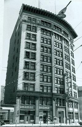
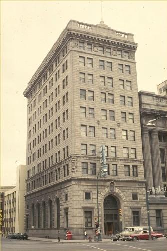
Former Union Bank Building / Annex National Historic Site of Canada
Winnipeg, Manitoba
The former Union Bank Building/Annex is located on the west side of Main
St. at the point where it curves southwards from Winnipeg's historic
City Hall. Together with the Confederation Life Assurance Building (also
a skyscraper and National Historic Site) across Main Street on the east
side, the Union Bank comprises the towering gateway to Winnipeg's
historic financial district.
Designed by the Toronto architectural firm of Darling and Pearson, this
bank follows the classical palazzo model, one of two Beaux Arts-inspired
forms used for early skyscrapers -- buildings of greater than 5 storeys
supported entirely by a structural iron or steel frame. It was built on
a floating platform by the George A. Fuller Construction Co. of New
York. In 1921 a single storey annex was added to the original 10 storey
tower to accommodate the Union Bank's savings department. From 1925-1966
this building was occupied as the main branch of the Royal Bank in
Winnipeg.
|

©Parks Canada Agency / Agence Parcs Canada, 2006 |
Fort Dauphin National Historic Site of Canada
Winnipegosis, Manitoba
In the fall of 1741, at the request of the Crees and Assiniboines,
Pierre de la Vérendrye built in this vicinity fort Dauphin.
|
©Parks Canada Agency / Agence Parcs Canada |
Fort Dufferin National Historic Site of Canada
Emerson, Manitoba
Located in a rural area north of the town of Emerson, Manitoba, on the
west bank of the Red River, Fort Dufferin National Historic Site of
Canada consists of the remains of a complex of buildings that was used
as the main camp for the North American Boundary Commission (NABC) from
1872. It was then used by the North West Mounted Police (NWMP) in
preparing for the March West and as a police post during the winter of
1875.
Beginning in 1872, Fort Dufferin served as the base of field operations
for the North American Boundary Commission, which worked for the next
two years to define and mark the 49th Parallel. Subsequently, the North
West Mounted Police used Fort Dufferin on two separate occasions, first
in 1874 as the marshalling area for the "March West" and then in the
winter of 1874-1875 as the headquarters of 'D' Division. Between 1875
and 1879, Fort Dufferin served as a port of entry to Manitoba and
gateway to western Canada. Fort Dufferin's role as immigration station
lasted only as long as boats on the Red River were the main mode of
transport for immigrants to Manitoba. The property subsequently served
as a livestock quarantine station before being sold to private owners,
and then finally to the Province of Manitoba.
|

©Parks Canada Agency / Agence Parcs Canada, HRS 1026, 1985 |
Fort Garry Hotel National Historic Site of Canada
Winnipeg, Manitoba
The Fort Garry Hotel is an early-20th-century stone hotel, constructed
in the Chateau style. It is centrally located in the city of Winnipeg,
one block west of Winnipeg Union Station.
The Fort Garry Hotel was designated a national historic site in 1980
because it is a Chateau-style hotel, which is of national significance
as an architectural type.
The Fort Garry Hotel is one of a series of Chateau-style hotels built by
Canadian railway companies in the early 20th century to encourage
tourists to travel their transcontinental routes. Popular with the
travelling public for their elaborate decor and comfortable elegance,
these hotels quickly became a national symbol of quality
accommodation.
The Chateau-style vocabulary used by the railway hotels evolved as a
distinctly Canadian architectural type. Built by Fuller Construction for
the Grand Trunk Pacific Railway (GTPR) in 1911-1913, the Fort Garry
combines a Chateauesque roofline with the monolithic form of a
20th-century skyscraper. Architects Ross and MacFarlane incorporated
motifs found on other railway hotels, including the trademark GTPR
Indiana limestone walls. The dramatic setting characteristic of
Chateau-style railway hotels was achieved here by erecting a 13-storey
structure that dominated the flat, prairie landscape, and by placing the
main reception rooms on the seventh floor to provide a commanding view
of the city.
|
©Parks Canada Agency / Agence Parcs Canada, Blair Philpott, 2008 |
Fort La Reine National Historic Site of Canada
Portage la Prairie, Manitoba
Fort La Reine National Historic Site of Canada is located on the north
bank of the Assiniboine River, on the eastern edge of Portage La
Prairie, Manitoba. There are no known remains relating to Fort La Reine,
but a stone cairn and plaque have been erected by the Historic Sites and
Monuments Board of Canada (HSMBC) to commemorate the site.
The heritage value of Fort La Reine resides in its historical
associations with the early exploration of the West during the French
Regime. The first Europeans to visit this area were probably the French
explorers Radisson and Groseillers who explored the region between 1658
and 1690 in search of furs. In October 1738, Pierre Gaultier de
Varennes, Sieur de La Vérendrye, established Fort La Reine on the
Assiniboine River. The fort was used as a base for further exploration
of the Canadian prairies and as one of the chief French trading posts
until the end of France's influence in 1759. There is evidence to
suggest that Fort La Reine was abandoned, burned and rebuilt several
times, although its exact locations and dates are unknown.
|

©Library and Archives Canada / Bibliothèque et Archives Canada, C-001932, 1821
©Library and Archives Canada / Bibliothèque et Archives Canada, PA-011337, c. 1872. |
Forts Rouge, Garry and Gibraltar National Historic Site of Canada
Winnipeg, Manitoba
Fort Rouge, - La Vérendrye, 1728; Fort Gibraltar, - North West Company,
1810; Fort Garry - Hudson's Bay Company, 1822
Forts Rouge, Garry and Gibraltar National Historic Site of Canada is
located on three different positions at the forks of the Red and
Assiniboine rivers in downtown Winnipeg, Manitoba. The only original
surviving above-ground element is the north gate of Fort Garry II
located in Upper Fort Garry Park, the walls of which have been partially
reconstructed. The sites of the two forts Gibraltar and the first Fort
Garry have been identified adjacent to Union Station, while the site of
Fort Rouge is believed to be on South Point, immediately south across
the Assiniboine River.
Located at the forks of the Assiniboine and Red rivers, Forts Rouge,
Garry and Gibraltar illustrate the evolution of the fur trade in the
west, from expansion westward to the dominance of the North West Company
and the Hudson's Bay Company.
Built in 1738, Fort Rouge was part of Pierre Gaultier de Varennes et de
la Vérendrye's westward expansion of the fur trade on behalf of France,
and was used as a trading post for the local Aboriginals. The fort may
have operated for only one season, and by 1807, Fort Gibraltar was built
near its site by the North West Company. It became the company's main
fort in the interior and served as a pemmican post, providing supplies
further inland, until it was destroyed in 1816 during a conflict with
the Hudson's Bay Company. When the two companies merged in 1821, the
fort was rebuilt as Fort Garry. Built on or near the site of Fort
Gibraltar, Fort Garry became the chief fort at Winnipeg, although its
unstable position near the river's edge required it to be moved to
higher ground by 1836. Partially demolished in 1882, the northern gate
of Fort Garry II constitutes the only above ground remains of the
succession of forts around the confluence of the Red and Assiniboine
rivers.
|

©Parks Canada Agency / Agence Parcs Canada, 1986 |
Grey Nuns' Convent National Historic Site of Canada
Winnipeg, Manitoba
Grey Nuns' Convent National Historic Site of Canada is a gracious
two-storey hipped roof structure showing influences of Hudson's Bay
Company construction techniques in its squared log construction and
European classicism in its symmetrical nine-bay facade. Sited facing the
Red River and downtown Winnipeg, it is an important element in the
historic Roman Catholic ecclesiastical complex of St. Boniface. The
building now serves as the St. Boniface Museum.
This convent, which housed the first group of Grey Nuns to come to the
West, was constructed between 1846 and 1851 to designs of Sister
Marie-Louise Valade and L'Abbé Louis-Francois Richer Laflèche of Quebec
working with local builders Louis Galarneau and Amable Nault. The
convent was built of white oak logs and subsequently repaired and
enlarged to meet changing needs. It is an outstanding example of Red
River frame construction. As a mission house, it provided facilities for
the Nuns' various works of health care, education and charity, which
included caring for the aged and for orphans, treating the sick, and
instructing children. It was the first institution of this kind in the
west. Vacated by the nuns in the 1950s, it was leased by the City of St.
Boniface (now the city of Winnipeg) and rehabilitated for use as a
museum.
|

©Parks Canada Agency / Agence Parcs Canada, 1994 |
Holy Trinity Anglican Church National Historic Site of Canada
Winnipeg, Manitoba
Surrounded by the large glass and steel buildings of downtown Winnipeg,
Holy Trinity Anglican Church National Historic Site of Canada has
witnessed the evolution of the district from open prairie to commercial
core since its construction in 1883-1884. Recalling parish churches in
England, this picturesque rough-cut limestone church is a fine example
of High Victorian Gothic style, with the lively interplay of form and
detail of finials, buttresses, gables and rooflines. The building has
retained an astonishing amount of its original elements, although the
main entrance on Donald Street has been sealed and access to the church
is now routed through the parish hall. Set within a compact landscaped
churchyard, Holy Trinity Church continues to be a vibrant parish within
the Anglican Diocese of Rupertsland.
When the parish of Holy Trinity outgrew its second church after its
formation as a parish in 1867, the congregation awarded the $300 design
competition prize to a British-born architect Charles H. Wheeler. An
active member of the congregation himself, Wheeler's design delighted
the small ambitious city, but the parish was ultimately obliged to forgo
permanently a grand bell tower and spire planned for the southwest
corner, due to a lack of funds. Completed in 1884, this church features
a cruciform plan in an irregular outline with dormered clerestory
windows along the steeply pitched gable roof. The rough-cut honey
coloured limestone of the walls is further employed to great advantage
in labels over the many pointed windows, and in the dripstones, which
end in human faces over the entrances. Twinned buttresses carry the
roofline down, each capped with a fanciful turret. A variety of stone
crosses over the many gable and dormer peaks speak to the evolution and
cultural breadth of this Christian symbol.
The interior features an elaborate hammer beam ceiling and magnificent
stained glass windows. Within its pointed arches, the elaborate Gothic
tracery of the chancel and entrance windows is reduced to a simpler form
in the windows along the nave. Above, each clerestory window exhibits
the trefoil tracery appropriately symbolizing the Holy Trinity. Finished
in a dark stained wood, the hammer beam ceiling continues the window
tracery in a larger scale that weaves up in an elaborate manner, the
arches carried down on to painted pillars capped with a display of cast
human and animal heads, scrolls and leaves. With most of its original
layout and furnishings intact, the church interior has a remarkable
integrity, which has been supported by a long-term regime of maintenance
and care.
A 1912 church hall that blocked the stained glass window at the rear of
the chancel was replaced in 1966 with a lower structure, which was more
sensitive to the design of the church, while still providing much-needed
space for the parish's many activities.
|

©Heritage Recording and Technical Data Services, Heritage Conservation Program, RPS, "Designated Building Heritage Recording Report: Preliminary Record of 5 Grain Elevators, Inglis, Manitoba", September/October 1996

©Heritage Recording and Technical Data Services, HCP, RPS, "Preliminary Record of 5 Grain Elevators, Inglis, Manitoba", September/October 1996, photo 07526/23 |
Inglis Grain Elevators National Historic Site of Canada
Shellmouth-Boulton, Manitoba
In the small town of Inglis, Manitoba, a row of tall wooden elevators
are lined up parallel to the railway tracks. This is the Inglis Grain
Elevators National Historic Site of Canada - a rare surviving icon of
prairie towns during the "golden age of grain." The elevators, no longer
in active use, are preserved as a historic site.
The heritage value of Inglis Grain Elevators National Historic Site of
Canada lies in its symbolic, visual and substantial representation of a
phenomenon typical of the landscape of prairie towns through the early
and mid 20th century.
These five grain elevators were built along a Canadian Pacific Railway
right-of-way that served the newly created town of Inglis, completed in
1922. Four of these elevators were constructed during the golden age of
grain; the fifth was built during the Second World War. They were built
by companies familiar to such locations — N.M. Paterson & Son (1922),
the Northern Elevator Company (1922), Matheson-Lindsay (1922-23),
Reliance (1941), and the United Grain Growers (1925). Ownership of these
buildings consolidated and changed over the years, encompassing other
familiar companies such as the National Grain Company, the Manitoba
Wheat Pool. Since the elevators closed in 1995, they have been restored
for tourism purposes.
|

©Parks Canada Agency / Agence Parcs Canada, 1996 |
Linear Mounds National Historic Site of Canada
Melita, Manitoba
Aboriginal burial mounds from 1000-1200 AD.
Located near the Souris River in southern Manitoba, the Linear Mounds
burial site is a sophisticated construction consisting of three mounds
spread out over a large area of land. The first is a linear mound with a
round terminal mound at either end, approximately 258 metres long and
running north to south. The second is a linear mound, also with a round
terminal mound at each end, 194 metres long, and running east to west.
The final mound is conical, approximately 22 metres in diameter and
lying just west of the south end of the north-south mound.
These burial mounds, dating from approximately 900 to about 1400 AD, are
complex constructions of soil, bone and other materials. The excellent
state of preservation of these mounds has yielded a wealth of
information concerning life in the Great Plains at this time, revealing,
by the nature of the goods in the burial mounds, that the peoples of
this area were part of a continent-wide trading network. The mounds have
now been ascribed to the Devil's Lake-Sourisford Burial Complex, a
network of related sites containing both linear and conical mounds which
extends from southern Saskatchewan and Manitoba to Montana and North and
South Dakota, based on similarity of artifacts discovered in mounds.
This complex dates from approximately 900-1400 AD, putting it in the
Late Woodland period.
|
©Parks Canada Agency / Agence Parcs Canada, 2014
©Parks Canada Agency / Agence Parcs Canada, 1993 |
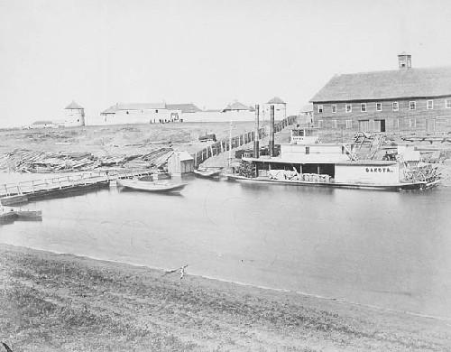
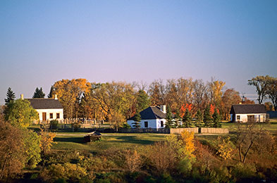
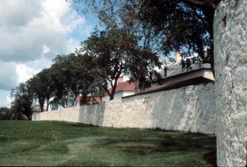
Lower Fort Garry National Historic Site of Canada
Selkirk, Manitoba
Major centre in 19th-century fur trade, Hudson's Bay Company.
Lower Fort Garry National Historic Site of Canada is a former fur trade
post, once the most extensive in western Canada. Situated near Winnipeg,
Manitoba, 30 km. upstream from the junction of the Assiniboine and Red
Rivers, this 85-acre site encompasses a four-acre Hudson's Bay Company
fort comprised of several buildings within a stone wall, a number of
restored and reconstructed buildings outside the walls, as well as a
portion of the camping sites of over 2,000 Ojibway and Swampy Cree
people who attended the signing of Treaty 1. It is now operated by Parks
Canada as a historic site open for public visitation.
Lower Fort Garry was established by the Hudson's Bay Company in 1830,
and operated as a company post until 1911. Construction of the fort
itself (1830-1850s) was largely guided by Governor George Simpson. After
the Government of Canada acquired Hudson's Bay lands in the west (1870),
various government officials and functions occupied the fort's
facilities together with fur trade officials; as a result, the fort has
been both witness and symbol for much of western Canada's early history.
From 1913-1962 the fort was leased to the Motor Country Club. The
Hudson's Bay Company donated the complex and its associated land to
Parks Canada in 1951, and since then (1965-1982) many of its structures
have been restored and interpreted to the 1850-1860 period for public
visitation.
The heritage value of Lower Fort Garry lies in its role as witness to
the negotiation and signing of Treaty 1, and to over a century of
Hudson's Bay Company administrative and supply activities. Its value is
embedded in its location, its setting, orientation and composite
elements. The buildings of the fort are of particular importance for
their assemblage, design, materials, construction technology, functional
and spatial disposition.
|

©Corporation Maison Gabrielle-Roy, 2007 |
Maison Gabrielle-Roy National Historic Site of Canada
Winnipeg, Manitoba
Maison Gabrielle-Roy National Historic Site of Canada is located on a
narrow lot in a quiet residential neighbourhood in St. Boniface,
Manitoba. The fine, large two-and-a-half storey wood-frame house was
constructed in the Vernacular style and has an L-shaped plan. The house,
which has been restored to its 1918 appearance, was the birthplace of
Canadian writer Gabrielle Roy, who lived there until 1937.
The heritage value of the house stems from its association with
Gabrielle Roy, one of the greatest Canadian writers of the 20th century
and a National Historic Person. The house is therefore not only the
birthplace, but also the backdrop for Gabrielle Roy's childhood, youth
and young adulthood. All her life, she remained deeply attached to the
house of her birth, particularly the attic, which is closely associated
with a specific period in her life and her early interest in writing,
that provided a great deal of inspiration for many of her works. As
witnessed by the references and allusions in many of her books,
especially Street of Riches and Enchantment and Sorrow, Gabrielle Roy
was inspired not only by the house itself, but also by the events that
took place there and the neighbourhood in which it stands. They offered
her an inspiring microcosm which she idealized and from which she drew
universal themes. Her attachment to the house is evident in many of her
books and also in her personal life through her quest for similar places
to live. Restored between 2001 and 2003, the house helps preserve the
memory and work of this fine Canadian author.
|

©Manitoba Archives, 1959 |
Metropolitan Theatre National Historic Site of Canada
Winnipeg, Manitoba
The Metropolitan Theatre at Winnipeg is an early-20th-century movie
theatre. It is located in the heart of downtown Winnipeg.
The Metropolitan Theatre was designated a national historic site in 1991
because: it is a fine example of the work of prominent American theatre
architect C. Howard Crane; it represents the cultural impact of the
movie theatre in the 1920s; and it is associated with the corporate
struggle between the Allen and Famous Players Theatre chains for
supremacy in the film distribution industry in Canada.
The Metropolitan is one of three surviving Canadian examples of Crane's
work, and a good example of an early phase of his international work.
Its exterior facade typifies cinemas designed by Crane for the Allen
theatre chain. The interior, modified in the 1930s, is representative of
the work of theatre designer Emmanuel Briffa.
The Metropolitan, originally called the Allen, is one of four surviving
movie theatres in Canada built by the Allen brothers, Jay and Jule, and
their father, Bernard. During the early 20th century, the Allen family
ran the biggest cinema chain in Canada, and one of the largest in the
world. One of the first of the large, opulent "movie palaces" built in
Canada, the Metropolitan represents the impact of the Allen cinema chain
on Canadian life and its contribution to the Canadian film industry. By
promoting movies and moviegoing, and by erecting large, opulent movie
palaces across the country, the Allen family helped to elevate movies to
a form of reputable, accessible and affordable entertainment. The Allens
were strong promoters of Canadian content.
In Winnipeg, the Metropolitan was built on the same street with a
now-demolished Famous Players theatre of comparable size and opulence,
whose construction signalled the beginning of a battle for supremacy
between the Allen and Famous Players cinema chains. The Metropolitan
represents the intense competition between the two chains during the
early 1920s, which led to flamboyant promotions, greater movie
attendance, and the construction of similarly paired Allen and Famous
Players theatres in other Canadian cities. The competition ended with
collapse of the Allen empire in 1923 and the acquisition of many of its
theatres, including the Metropolitan, by Famous Players.
|

©Parks Canada Agency / Agence Parcs Canada, 1993 |
Miami Railway Station (Canadian Northern) National Historic Site of Canada
Miami, Manitoba
The Miami Railway Station is a small, wooden storey-and-a-half railway
station located beside the tracks in the agricultural community of
Miami, Manitoba.
The Miami Railway Station was designated a national historic site in
1976 to commemorate the development of the Canadian Northern Line and
because it is a rare surviving example of a Canadian Northern railway
station.
Formed in 1899 by William Mackenzie and Donald Mann as a result of the
amalgamation of two small Manitoba branch lines, the Canadian Northern
Railway grew quickly to become a transcontinental railway system. The
present station, built around 1905, is typical of many standard design
frame depots erected by the Canadian Northern across the prairies. It
reflects the brief period of prosperity enjoyed by Miami during the
railway boom of the early 20th century. The station operates as a rail
museum during the summer months.
|
©Manitoba Archives, 1960 |
Miss Davis' School Residence / Twin Oaks National Historic Site of Canada
Miami, Manitoba
Miss Davis' School Residence / Twin Oaks National Historic Site of
Canada is located on one of the original river lots along River Road,
approximately 10 kilometres north of the city of Winnipeg. Constructed
sometime between 1853 and 1866, the former school is a large two-storey
limestone structure on an extensive treed lot that was first settled as
part of the earliest Red River's Lower Settlement. The area retains its
largely rural nature, despite some adjacent residential
development.
Miss Davis' School Residence / Twin Oaks was constructed by Duncan
MacRae, a Scottish stonemason, who oversaw much of the stone
construction in Red River. While the homes of several local families
were built in this manner, developed by the Hudson's Bay Company in
forts and posts throughout North America, only a small number have
survived along the Red River Corridor.
Responding to petitions for the education of their daughters from local
families and Hudson's Bay Company officers across Canada, the Anglican
Church Missionary Society persuaded Miss Matilda Davis, the daughter of
a Hudson's Bay Company employee, who was educated in England, to open
this school in conjunction with the mission of St. Andrews Anglican
Church. Although some were day students, most of the girls boarded in
the big house, where they received classes in French, music, drawing,
dancing, needlework and deportment befitting young English ladies. Two
log cabins on the property were also erected as classrooms, one of which
is thought to survive on the property in a much-altered state as a
garage with an office above.
The school, known as Oakfield, St. Andrew's Establishment for Young
Ladies, closed following the death of Miss Davis in 1873. It became a
private residence, surviving with few changes until its new owners were
obliged to undertake a restoration in 1935. Renamed Twin Oaks, the house
had, in addition to major interior alterations, its stone walls
repaired, a basement added, and the glazing of its ground-floor windows
and front door transom altered. Twin Oaks, which underwent a second
major restoration in the late 1990s, continues to serve as a private
residence. The integrity of the exterior design of the limestone house
is largely intact, with the original massing, form and design enduring
from its earlier function as a school.
|
©Parks Canada Agency / Agence Parcs Canada, 2001 |
Neepawa Court House / Beautiful Plains County Court Building National Historic Site of Canada
Neepawa, Manitoba
A stone's throw from the commercial heart of the town of Neepawa,
Neepawa Court House / Beautiful Plains County Court Building National
Historic Site of Canada is an imposing two-storey buff brick building,
located on an open site. Constructed in 1884, when the surrounding
district was in its earliest stage of settlement, the structure served
as county and municipal offices, a circuit judges' courthouse, police
station and theatre, thereby securing Neepawa's role as the most
prominent town in the district. The building now houses offices of the
Municipality of Rosedale.
Having secured the railway line to the village in 1882, Neepawa was
thereafter named the seat of the County of Beautiful Plains, which
encompassed four municipalities. The county system, discontinued as too
unwieldy after 1890, continued to lend its name to the new provincial
building, although the town actually straddled the newly created Rural
Municipalities of Langford and Rosedale. In 1884, the government of
Manitoba agreed to share the cost of construction of the new civic
structure if space could be provided for the circuit judges' court, thus
making the town both the district judicial and civic centre. Town
leaders in Neepawa wasted no time in securing an architect and
commencing construction. Completed in 1884, the new brick courthouse and
civic office remained the town's only brick structure for the next five
years, serving as county court, town hall, jail, and theatre
The design was awarded to one of the young province's foremost
architects, British-trained C. Osborn Wickenden, who contributed several
prominent public buildings to Manitoba and later to British Columbia. A
Portage la Prairie construction firm had the expertise to provide the
skillful handling of the decorative brickwork of the courthouse. The
high-quality bricks were also manufactured in Portage, which speaks to
the sophistication of artisan skills developing on the Prairies. In
1982, strong local support for the preservation of the Neepawa Court
House / Beautiful Plains County Court and municipal offices as part of
the town's centennial anniversary celebration demonstrated how
significant a landmark it remains within the district.
|
©Parks Canada Agency / Agence Parcs Canada |
Neubergthal Street Village National Historic Site of Canada
Rhineland, Manitoba
Neubergthal Street Village National Historic Site of Canada was founded
in 1876 by a group of related Mennonite families on the open plains of
southern Manitoba. The village is now surrounded by flat farmland. The
community occupies six sections of land where residences, farmyards, and
communally owned arable fields and pasturelands are arranged in long
narrow farmsteads. The farmsteads that form the village are positioned
in traditional fashion behind fencing along a single tree-lined street,
creating a distinct identity.
Neubergthal Street Village is a living illustration of a Mennonite
village on the Canadian Prairies. Its heritage value rests in the
distinctive settlement forms resulting from Mennonite traditions of
community development and architectural forms that express a belief in
an egalitarian, communal and self-sufficient social structure. A group
of related families, the children of Johann and Margaretha Klippenstein,
founded the village in 1876. They settled on land, which, together with
some additional families, they entered as homesteads between 1876
through the 1880s. The street village formation was a good model for
settlement because it required close interaction and cooperation among
residents. Villagers assisted each other with harvesting and threshing,
butchering and building. The church, as the central institution of
village life, defined how they made their living, governed themselves,
and generally defined their values and behaviour.
|

©Library and Archives Canada / Bibliothèque et Archives Canada, C-000652 |
Norway House National Historic Site of Canada
Norway House, Manitoba
Norway House National Historic Site of Canada consists of the remnants
of the former Hudson's Bay Company fort at Norway House, Manitoba. The
three wooden buildings, the Archway Warehouse, Gaol and Powder Magazine,
sit in the stark landscape, near the banks of the Nelson River, at the
north end of Lake Winnipeg.
The heritage value of Norway House lies primarily in its historical
associations as the Hudson's Bay Company's principal inland depot for
the fur trade. It is also the place where Treaty No. 5 was made between
the Saulteaux (Ojibwa), the Swampy Cree First Nations people and the
Crown in 1875. It was also the site where the Rev. James Evans invented
the Cree Syllabic System. Norway House was established on this site in
1825-26. Surviving buildings including the Archway Warehouse
(1839-1841), the Gaol (1855-1856), and the Powder Magazine (1837-1838)
bear witness to this history.
|

©Parks Canada Agency / Agence Parcs Canada 1995. |
Pantages Playhouse Theatre National Historic Site of Canada
Winnipeg, Manitoba
Pantages Playhouse Theatre National Historic Site of Canada is a former
vaudeville theatre built in the early twentieth century in downtown
Winnipeg, Manitoba. Its Edwardian baroque façade, with its classical
detailing and full-length marquee signals its original prestige as a
public venue.
The heritage value of the Pantages Playhouse Theatre National Historic
Site of Canada lies in the integrity with which its features continue to
represent the characteristics of vaudeville theatres from the 1913-1930
period. Winnipeg's Pantages Playhouse Theatre was designed by architects
George W. Northwood and B. Marcus Priteca and built in 1913-14 for the
Pantages Company, a major American vaudeville chain, to present live
theatrical, musical and vaudeville performances. Theatres of this type
are among the grandest ever built in Canada. The Pantages Playhouse was
acquired by the City of Winnipeg in 1923, and the city has continued to
run it since that time.
|
©Parks Canada Agency / Agence Parcs Canada, 1982 |
Portage La Prairie Public Building National Historic Site of Canada
Portage La Prairie, Manitoba
The Portage La Prairie Public Building, now the city's City Hall, is a
substantial two-and-a-half storey buff-coloured limestone public
building with a roof of grey galvanized iron. Prominently located on the
main street of Portage la Prairie, it was constructed in 1896-98 as the
Dominion Post Office, Customs House and Inland Revenue office for an
ambitious town. Designed by Thomas Fuller, the Chief Dominion Architect
of the National Department of Public Works, the building blends
architectural elements drawn from Second Empire, High Victorian Gothic
and Richardsonian Romanesque styles.
As a newly independent nation in the late 1800s, Canada needed its
government to provide basic services within its jurisdiction across the
developing continent. The Department of Public Works named a Chief
Architect to oversee construction of buildings to house these services
as well as to establish a recognizable federal presence. Thomas L.
Fuller (1823-1898) was an English architect whose term as Chief
Architect (1881-1898) saw many buildings constructed across the country.
The post office in Portage la Prairie, completed in 1898, was one of 66
small urban post offices constructed in the period, of which only this
one survives in western Canada.
While each of the 66 buildings contributed to an identifiable genre,
they were designed individually to be compatible with their sites and to
use materials readily available locally. Standard plans included an open
hall plan on the main floor that was broken into a lobby and a
mail-processing area. Upstairs were the offices of the Customs and
Internal Revenue departments. The third floor served as the living
quarters for the caretaker; the basement held storage, the furnace and
the fuel supply (coal).
The exterior of the Portage La Prairie Public Building continues
Fuller's vision, which was carried out in public buildings across the
country. Executed in rough-faced limestone with dressed stone trim, the
building rests on a foundation of rubble fieldstone while its upper
floors are made of timber frame carried internally on cast iron columns.
Like other of Fuller's design, this building shows eclectic stylistic
influences. The symmetrical bays and flanking front entrances, the
mansard roof and the classical details show the influence of the French
Second Empire style, while the varied roofline, attention to the colour
and texture of the stone and advancing and receding volumes blend in a
High Victorian Gothic influence. The varied massing and wide voussoir
trim over the doors and windows express the American influence of
Richardsonian Romanesque style, all typical of public buildings of the
era.
Despite its adaptation to continuing changes in government processes,
the Portage La Prairie Public Building has seen little exterior
alteration with the exception of window replacement and the construction
of a single-storey addition to the rear during the renovations of
1920-1922. Materials, rhythms and details of this addition were blended
sensitively as the Public Building was expanded to meet the increased
need for space for Customs offices. The building was rehabilitated in
1960 as the Portage la Prairie City Hall. Civic administration and the
mayor's office now fill the main floor while the second floor has seen
use as a court, a library and an arts centre. Two prison cells remain
from a period when the RCMP detachment occupied the basement. In 2005,
the two original entrances, the stairway on the west side and the upper
floors' millwork were restored to maintain the viability of City Hall
for the future.
|
©Parks Canada Agency / Agence Parcs Canada, 2014
©Parks Canada Agency / Agence Parcs Canada |
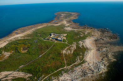
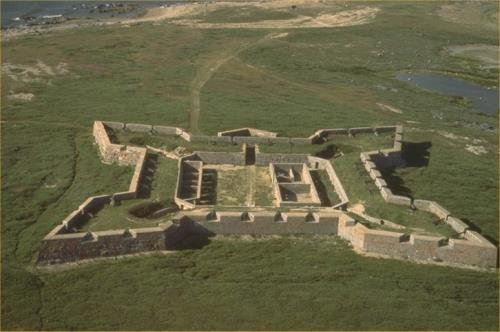
Prince of Wales Fort National Historic Site of Canada
Churchill, Manitoba
18th-century stone fur trade fort; Hudson Bay Company.
Prince of Wales Fort National Historic Site of Canada near Churchill,
Manitoba encompasses a massive fortification along with installations at
Cape Merry and Sloop Cove. Here, you can experience the diverse history
of the Hudson's Bay Company and the fur trade of the 1700s. The Parks
Canada Visitor Centre in Churchill, provides an excellent introduction
to the sites with exhibits and special presentations.
Prince of Wales Fort National Historic Site of Canada is a ruinous early
18th-century fur trade fortress built by the Hudson's Bay Company.
Surviving stone walls stand starkly silhouetted on the tundra along the
shore of Hudson's Bay at the mouth of the Churchill River in northern
Manitoba.
The heritage value of Prince of Wales Fort lies in its historical
associations and in the physical remains of the fort and its cultural
landscape. Prince of Wales Fort was built by the Hudson's Bay Company in
1731-1771 at a time when its major shipment and supply route operated
from Hudson's Bay through Arctic waters. The fortress was constructed to
be an impregnable English stronghold, and today its imposing 12 m thick
walls and 40 mounted cannon still survive along with the battery, cannon
and powder magazine built to safeguard it on Cape Merry. As commander of
the fort, Explorer Samuel Hearne surrendered it to the French in 1782,
an act that terminated Hudson's Bay occupation and terminated Prince of
Wales Fort's utility. Parks Canada engaged in limited repair and
restoration of the fortress walls in the 1935-1965 period.
|
©Parks Canada Agency / Agence Parcs Canada, Danielle Hamelin, 2008 |
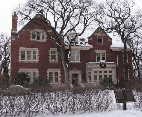
Ralph Connor House National Historic Site of Canada
Winnipeg, Manitoba
Ralph Connor House National Historic Site of Canada is located in
central Winnipeg Manitoba, in the residential area of Armstrong's Point.
This spacious and dignified three-storey brick and stone residence was
built from 1913 to 1914 for the Reverend Charles Gordon, a well-known
Presbyterian minister who, under the pen name of Ralph Connor, also
wrote best-selling novels. Gordon lived in the house until his death in
1937, after which it became the home of the University Women's Club of
Winnipeg. The site includes the main house, a coach house and the
surrounding landscaped property.
The heritage value of Ralph Connor House lies in its associations with
Reverend Charles Gordon and his very public position as a best-selling
Canadian author under the pen name Ralph Connor. Constructed from 1913
to 1914 when Gordon was at the height of his career, 54 West Gate is
closely associated with the life and legacy of the minister and
novelist. Gordon chose Armstrong's Point, an exclusive central
neighbourhood of Winnipeg's social and financial elite, for his family
home. It is a fine example of houses built in this area, featuring
asymmetrical façades, an irregular roofline, bay windows, and exterior
walls of rich red brick trimmed with Tyndall stone.
While the house was not a subject of his writings, 13 of Gordon's 22
novels were published while he was living at 54 West Gate. As one of
Canada's best-known writers, he played a prominent role in Canadian
Authors Association, established in 1921. At the national level, Gordon
was a member of the association's first council, and served as president
for two terms in the mid-1930s. He was also active in the Winnipeg
branch, which for years held its meetings at 54 West Gate.
The house also represents the public face of Reverend Gordon as, for
twenty-five years, it acted as both the manse and the family home of
this leading Presbyterian churchman and social activist. The layout of
the house clearly reflects this dual role. The formal front entrance was
the "business" entrance used by his parishioners, leading to an office
and to Gordon's study. The carriage entrance with porte-cochere and
terrace on the south side was the family entrance, leading to the
private spaces of the house. The house was well designed to accommodate
Gordon's congregational work and social activism. The study was where he
composed his sermons and conducted parish business. The front entrance
of the house opened into a vestibule where parishioners were received; a
hallway led to a secretary's office and then to Gordon's study,
furnished with a large desk, comfortable chairs, and dictionaries and
reference books on stands. This area of the main floor was designed to
give privacy from the family rooms of the home.
|
©Parks Canada Agency / Agence Parcs Canada, Richard Stuart, 1997 |
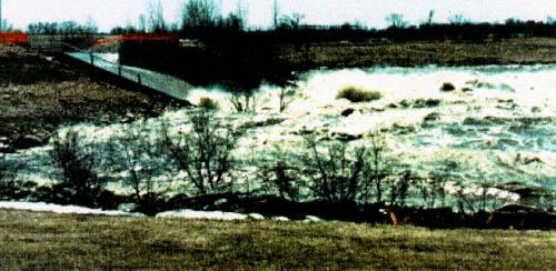
Red River Floodway National Historic Site of Canada
Winnipeg, Manitoba
The Red River Floodway National Historic Site of Canada is part of a
massive flood control system that lies east of Winnipeg, Manitoba. The
city itself is located on a flood plain at the confluence of the Red and
Assiniboine Rivers, on one of the flattest areas in North America.
Engineered between 1962 and 1968 to protect Winnipeg from threat of
flooding by the Red River, the floodway detours excess waters harmlessly
eastwards around the city, where it rejoins the river further
downstream.
The Red River has flooded many times in documented history, often with
disastrous consequences to nearby settlements. Known affectionately as
"Duff's Ditch" after its advocate, former Manitoba Premier Duff Roblin,
the floodway became the largest component in a comprehensive engineering
project launched by the Government of Manitoba in the 1960s to protect
its inhabitants. The Red River Floodway was built in response to the
catastrophic destruction of the 1950 flood in Manitoba, which flooded
almost one-tenth of the city.
Plans for the intake and outlet devices were drawn up by H.G. Acres &
Company Ltd., Consulting Engineers of Niagara Falls, in conjunction with
the Red River Floodway Advisory Board of Manitoba's Water Control and
Conservation Branch. As the largest excavation project undertaken in
Canada to date, construction was shared between the Northern
Construction Co. and J.W. Steward Ltd., both of Vancouver, and
Winnipeg's Bird Construction Ltd. and Horton Steel Works of Toronto
which fabricated the sector gates and hydraulic operating
pistons.
Impressive in scale and design, it is the great efficacy of the Red
River Floodway as an engineering achievement that defines its value.
Using available technology of hydraulics and a massive earthwork, its
designers were able to divert the natural, destructive force of the Red
River, thereby allowing the city of Winnipeg to grow and develop, secure
from the unpredictable threat of flooding. The gates of the Intake
Control Structures, which are located south of the city, control the
floodwaters from upriver and the 47-kilometre long floodway channel
detours excess water harmlessly eastwards around the city. Through the
exit spillway of the Outlet Control Structure north of the city,
floodwaters then rejoin the Red River as it nears its delta.
While extreme floods likes those in 1950 and 1997 are rare, the Red
River Floodway has been put into operation many times since its
completion, diverting floodwaters and preventing inundation to save
Winnipeg homes and businesses from extensive flood damages.
|
©Parks Canada Agency / Agence Parcs Canada |
Riding Mountain National Park of Canada
Headquarters: Wasagaming, Manitoba
Protected "island" area in the Manitoba Escarpment.
Riding Mountain National Park includes 3000 km2 of
possibilities, where the boreal forest, the aspen parkland, and the
fescue prairie greet visitors of all ages and abilities. Our welcoming
community and pristine wilderness will help you to reconnect with the
best of Manitoba and Canada, and offer you a vast array of opportunities
for relaxation, laughter, discovery and fun.
The picturesque town of Wasagaming, which bustles on busy summer days,
has been creating indelible family memories for generations. The East
Gate Registration Complex National Historic Site reminds us of the early
days of Canada's national parks system.
|
©Parks Canada Agency / Agence Parcs Canada

©Parks Canada Agency / Agence Parcs Canada, 2001 |
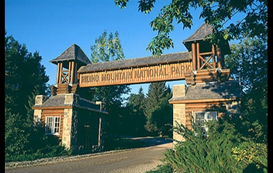
Riding Mountain Park East Gate Registration Complex National Historic Site of Canada
Riding Mountain National Park of Canada, Manitoba
Three rustic buildings built under depression relief programs.
The East Gate Registration Complex NHSC is a nationally significant
example of the Rustic Design tradition of the 1930's in Canada's
National Parks. It is the last of three log entrance gates in Riding
Mountain. This gate was constructed of indigenous materials by skilled
local craftsmen hired through the Federal Government's Depression Relief
Program. Comprised of a registration building and two staff cabins, the
East Gate Complex has symbolic value because its association with early
autotourism and outdoor recreation. It is an enduring landmark for
visitors to Riding Mountain National Park of Canada.
The Riding Mountain Park East Gate Registration Complex National
Historic Site of Canada comprises three log buildings of exceptional
rustic design, the Whirlpool Warden's Residence, the East Gate Entrance
Building, and the Gatekeeper's Cottage, in addition to a remnant of
Norgate Road that passes through the complex. Their design and materials
establish their identity as the eastern entrance to Riding Mountain
National Park of Canada. Nearby are several more recent wood-frame
service buildings.
The heritage value of the site lies in the complex's illustration of
exceptional rustic design in a National Park of Canada. The Riding
Mountain Park East Gate Registration Complex was constructed in 1933-36
by the National Parks Service to provide an eastern entrance to Riding
Mountain National Park of Canada for automobiles travelling on Norgate
Road (Highway 19). Both residences follow standard plans prepared by the
Architectural Division of the National Parks Branch.
|

©Parks Canada Agency / Agence Parcs Canada |
Riel House National Historic Site of Canada
Winnipeg, Manitoba
Family home of Métis leader Louis Riel.
As its name implies, this national historic site of Canada has close
ties with Métis leader and a founder of Manitoba, Louis Riel. Occupying
river lot 51 along the Red River, Riel House National Historic Site was
the home of the Riel family. Descendants of this family continued to
live in the home until 1969. It is here, in the living room of his
mother's house, that Riel's body lay in state for two days in December
1885. The house itself, a Red River Frame building (a style of
construction popular for this region) has been restored to the spring of
1886.
Riel House is a small one-and-a-half-storey, squared log house set on a
river lot on the east side of the Red River. Located in a residential
district at 330 River Road in St. Vital, a surrounding suburban
development that has changed its original rural character. The property
is associated with the family of Louis Riel.
The heritage value of Riel House lies in its association with Louis Riel
and in its representation of the Métis river lot settlement form. Its
river lot has particular importance as a symbol of the early stamp of
Métis culture upon the land. Built in 1880-81 on the site of an earlier
home acquired in 1864 by Louis Riel's mother, Riel House was occupied by
the family from the time of its construction to 1968. Louis Riel visited
the house briefly in 1883 and was laid in state in the home after his
execution in 1885. Since it was declared a national historic site in
1968, Riel House has been acquired by Parks Canada, restored and
furnished to represent the spring of 1886 when the family was in
official mourning following the execution of Louis Riel.
|
©Parks Canada Agency / Agence Parcs Canada, 1983 |
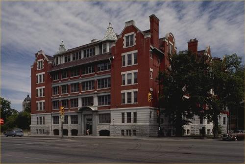
Roslyn Court Apartments National Historic Site of Canada
Winnipeg, Manitoba
Roslyn Court Apartments National Historic Site is a five-storey,
37-suite, red brick apartment building prominently located at the corner
of Roslyn Road and Osborne Street in Osborne Village, Winnipeg.
Roslyn Court Apartments was designated a national historic site in 1991
as a fine example of the Queen Anne Revival style and
turn-of-the-century apartment design.
The heritage value of this site resides in its illustration of the Queen
Anne Revival style as used for apartment building design in Canada in
the early twentieth century.
Roslyn Court Apartments, built in 1909, was designed by Winnipeg
architect William Wallace Blair. It is one of the few early 20th century
apartment buildings that still retains its original interior
features.
|

©Parks Canada Agency / Agence Parcs Canada, Andrew Waldron, 2007 |
Royal Manitoba Theatre Centre National Historic Site of Canada
Winnipeg, Manitoba
Royal Manitoba Theatre Centre National Historic Site of Canada is
located in downtown Winnipeg, Manitoba, within Exchange District
National Historic Site of Canada. The site consists of a Brutalist
structure, which features exposed reinforced concrete and substantial
massing. It was built between 1969 and 1970 as part of an urban renewal
project to create a complex of modern public buildings in downtown
Winnipeg. It was also constructed to house the Royal Manitoba Theatre
Centre's regional theatre group, which was established in 1958.
The opening of the Royal Manitoba Theatre Centre building in November
1970 concluded a long tradition of theatre building in Winnipeg. As part
of a cultural renaissance of the city's arts facilities in the 1960s,
the Royal Manitoba Theatre Centre building housed Canada's first
professional regional theatre group. At a time when large modern
theatres and concert halls were opening up across the country, the MTC
was designed as an intimate space that permitted a close relationship
between audience and actor. In addition, the Royal Manitoba Theatre
Centre was the country's first large regional theatre group with
educational programming and shows touring throughout rural Manitoba. The
newly founded Canada Council funded the theatre and promoted it as the
exemplary model of how to create a successful regional theatre.
The Royal Manitoba Theatre Centre is also an excellent expression of
small-scale Brutalist architecture in Canada. The buildings sculptural
form of exposed reinforced concrete, undressed formwork and solid
massing are key features of the style. The east and north façades of the
building feature sculptural double-height angled windows, designed to
allow natural light into the public foyer. In addition, the north side
of the building is punctuated by four semi-circular concrete projections
on the ground floor. There is an overall informality and asymmetry to
the building that is characteristic of small-scale Brutalism.
Equally important is the Royal Manitoba Theatre Centre's interior space.
At a time when Brutalist architecture was being well received publicly
as modern design, the Royal Manitoba Theatre Centre building introduced
a new concept of intimate Brutalist architecture. Rather than a formal
event space, the architects and theatre director worked together to
create a space that bridged the separation between the actors' and the
audience. The theatre's asymmetrical seating arrangement, flexible stage
design including a proscenium and "thrust stage," and foyer, are good
representative examples of this concept. The scenery preparation room
behind the stage is also open to viewing by theatregoers through a
window, allowing a glimpse behind the stage and furthering the intimate
theatre experience.
|

©Parks Canada Agency / Agence Parcs Canada |
Sea Horse Gully Remains National Historic Site of Canada
Churchill, Manitoba
The Sea Horse Gully Remains National Historic Site of Canada is located
on a peninsula forming the west site of the Churchill River, directly
opposite the town of Churchill, Manitoba. Set on the northernmost
segment of a bedrock ridge the site is covered by a layer of gravel,
stones and sand. The site comprises two archaeological components; the
Sea Horse Gully site, which runs 1.8 kilometres along the length of a
bedrock ridge at the height of the peninsula 30 metres above sea level,
and the Dorset Cove site, located on the western side of the peninsula
near Button Bay, measuring 400 by 300 metres that is 18-22 metres above
sea level.
The Sea Horse Gully site was discovered in 1966 by Joe Bighead, a local
Chipewyan man. In the summer of the same year, a wildfire destroyed the
mat of tundra vegetation that covered the sites revealing artifacts and
rock patterns of structures visible on the ground surface. A year later,
further excavations uncovered 24 Pre-Dorset dwellings, as well as a
large tool assemblage, domestic artifacts and other surface findings.
The variety of large tools found at Sea Horse Gully are virtually unique
as the only other site where similar tools have been discovered is the
Twin Lakes site southeast of Churchill. The site is believed to have
been occupied 500 BCE and 130 BCE. It is one of the larger Pre-Dorset
and Dorset sites in terms of number of artifacts.
|
|
Souris-Assiniboine Posts National Historic Site of Canada
Wawanesa, Manitoba
The confluence of the Souris and Assiniboine Rivers was a major
victualling centre for the fur trade. During the period 1793-1824, the
Hudson's Bay, North West, and XY Companies maintained posts in this area
to trade with the Indians between Lake Manitoba and Missouri River for
corn, pemmican, and fur. The Yellow Quill Trail crossed this region
carrying inter-tribal and fur trade traffic. Many famous traders and
explorers, including John Macdonnell, Cuthbert Grant, Peter Fidler,
David Thompson, Alexander Henry, and Daniel Harmon were associated with
these posts.
|

©Parks Canada Agency / Agence Parcs Canada, 1992 |
St. Andrew's Anglican Church National Historic Site of Canada
St. Andrews, Manitoba
St. Andrew's Church National Historic Site of Canada is a small stone
Gothic-Revival-style church located in the community of St. Andrew's,
Manitoba, some ten kilometres north of Winnipeg. Set in a churchyard on
the west bank of the Red River, at the northwest corner of River Road at
St. Andrew's Road, it is surrounded by a perimeter stone wall of rubble
masonry, dating from circa 1858.
This church, replacing an earlier wooden structure, was consecrated by
the Anglican Church Missionary Society as part of its mission in the Red
River Settlement in December of 1849.
This pioneer expression of the Gothic Revival style is distilled here to
its basic elements: a simple rectangular form, gable roof and tower. Its
Anglican Church Missionary Society minister, Rev. William Cockran,
designed the stone church, Hebridean stonemason Duncan McRae (1813-1898)
supervised construction, and carpenter John Tait provided interior
furnishings. Local parishioners donated funds, labour and the limestone,
which was quarried locally. Three iron bells set within the tower and
spire of the church called parishioners to worship. When St. Andrew's
ceased to function as a mission in 1886, it evolved to what it is today,
a place of worship in an active parish, and a landmark in the
province.
Changes in liturgical emphasis caused some interior modifications of the
altar placement in the nineteenth century. Structural failure of two of
the exterior stone walls required extensive repairs in 1931 and 1932.
Routine maintenance of wood in the windows and spire has also been
undertaken. Major structural repairs of the stone church's walls,
foundations, roof trusses and belltower took place in 1983 and the
1990's.
|
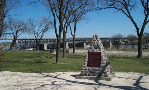
©Parks Canada Agency / Agence Parcs Canada 2004 |
St. Andrews Caméré Curtain Bridge Dam National Historic Site of Canada
Lockport, Manitoba
St. Andrews Caméré Curtain Bridge Dam is a 270 metre-long bridge-dam
spanning the Red River at Lockport, Manitoba. The bridge supports a
movable dam consisting of a series of Caméré curtains which maintain the
river at a navigable depth during the summer months and are rolled up
and removed each fall to enable the spring flood waters to pass
unimpeded under the bridge. A canal lock, constructed in the west bank
adjacent to the bridge-dam, carries river traffic past the dam. Today
the bridge-dam remains in service on provincial Highway #44.
St. Andrews Caméré Curtain Bridge Dam was designated a national historic
site of Canada because this engineering work is perhaps the only
surviving moveable dam of its type in the world.
The heritage value of this site is carried in the design and materials
of the structure itself. Erected by the Federal Department of Public
works between 1907 and 1910, it is the largest of its type ever
constructed. In 1912-1913, approach spans were added and a roadway built
across the bridge-dam. The approaches were modified and loading capacity
increased in 1947-1949. New frame and curtain cranes replaced the
originals in 1967. By that time railway and road transport had largely
replaced water transport, severely reducing the commercial use of the
river and canal system.
|
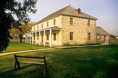
©Parks Canada Agency / Agence Parcs Canada

©Parks Canada Agency / Agence Parcs Canada, J. Butterill, 1995 |
St. Andrew's Rectory National Historic Site of Canada
St. Andrews, Manitoba
Example of mid 19th-century Red River architecture, 1852-1854.
St. Andrew's Rectory is an excellent example of mid-19th century Red
River architecture. Outdoor exhibits interpret Red River architecture,
and the roles of the Church Missionary Society and the Church of England
in the settlement of the Red River and Western Canada.
St. Andrew's Rectory National Historic Site of Canada is a large,
two-storey, stone country home built initially as a residence for the
Anglican priest of the parish. Originally constructed in 1851-54, it was
rebuilt by Parks Canada in the 1980s. The rectory occupies a prominent
hilltop location, close to St. Andrew's Anglican Church National
Historic Site of Canada and overlooking the Red River. The grounds of
the rectory have been restored by Parks Canada to reflect the
landscaping of the period between 1860 and 1870.
The Rectory reflects the Hudson's Bay style of architecture, which
adapted Scottish building techniques to the Canadian frontier. The bold
design of the rectory, its simple, clean lines, and its limestone
construction are typical of this style. The wooden verandah was a French
Canadian modification found throughout the Red River area. Originally
built by the Church Missionary Society as part of a complex of Anglican
mission buildings erected between 1830 and 1855, the significant scale
and sober design of the rectory reflect the respectable image
appropriate to an Anglican missionary. The building was dismantled in
the early 1980s and rebuilt true to the style and features of the
original.
|

©St. Boniface City Hall, Lil Zebra, 2005 |
St. Boniface City Hall National Historic Site of Canada
Winnipeg, Manitoba
Situated at a prominent intersection in St. Boniface, the
French-speaking mission that became an urban district of metropolitan
Winnipeg, the St. Boniface City Hall is a classically styled, three-
storey, red brick structure with central domed tower, built in the early
twentieth century.
Constructed by the William Grace Company of Winnipeg in 1905, the new
city hall was carefully planned to identify St. Boniface as separate
from its neighbouring municipalities in attracting population and
investment. The large size and formal Classical-revival style was
thought to convey the dominance, stability and optimism as a visual
symbol of the small city. Yielding to public pressure after its
construction, the architect replaced its original tower with the
existing one in 1911. An addition was made to the rear of the building
when it underwent restoration in 1988, at which time clocks were
installed in the tower. When St. Boniface ceased to be a separate city
on amalgamation with Winnipeg in 1972, this city hall was adapted as
space for the centralized civic administration.
|

©Parks Canada Agency / Agence Parcs Canada, 2005 |
St. Boniface Hospital Nurses' Residence National Historic Site of Canada
Winnipeg, Manitoba
St. Boniface Hospital Nurses' Residence National Historic Site of Canada
is located in the Winnipeg neighborhood of St. Boniface. Completed in
1928, it served as both an educational facility and a residence for
training professional nurses until the school closed in 1997. This
five-storey brick buildings is distinguished by its utilitarian design,
its symmetrical rectangular massing, regularly arranged windows, and
flat roof.
St. Boniface Hospital Nurses' Residence represents the recognition and
development of nursing as a profession. The School of Nursing at St.
Boniface Hospital was founded by the Grey Nuns in Winnipeg in 1897.
Constructed between 1927-1928, the St. Boniface Hospital Nurses'
Residence was purpose built to serve the school, and contains bedrooms,
recreational space and classrooms. In the school's modern classrooms,
laboratory and library facilities, young student nurses received a
modern, scientific education, critical to their professional careers. A
movement away from housing the student nurses in hospital wings, which
often exposed the students to unclean buildings, long hours and
infectious diseases, purpose built nurses' residences, such as the one
at St. Boniface Hospital, represented the growing recognition accorded
to nursing as a profession, as well as the granting of autonomous space
for women in the public sphere. Separate from the demands of the
hospital, the residence provided the students with an opportunity to
develop as a profession and to form an internal community of women with
common work and social interests. One of the best preserved nurses'
residences in Canada, the School of Nursing at St. Boniface Hospital
ceased to exist in 1997. Currently the building serves as the St.
Boniface General Hospital Residence and is affiliated with the
University of Manitoba.
|
©Parks Canada Agency / Agence Parcs Canada |
St. Michael's Ukrainian Greek Orthodox Church National Historic Site of Canada
Stuartburn, Manitoba
St. Michael's Ukrainian Greek Orthodox Church National Historic Site of
Canada, located in Gardenton, Manitoba, is a small, white wooden church
surrounded by farmlands built by the first group of settlers to
immigrate to Canada from Bukovina (now in western Ukraine). Its
distinctive massing, plan and "onion-dome" cupola reflect the
Byzantine-influenced architectural heritage of Ukraine. A nearby wooden
free-standing bell tower of stacked cube design was added in
1906.
Forty-three volunteers from the district constructed St. Michael's under
the supervision of Wasyl Kekof, a skilled carpenter from Bukovina.
Adapting age-old techniques using the available simple tools and found
materials, they began by cutting the logs in the winter of 1897-98. They
had arrived only months before, during the first wave of migration from
the western Ukraine, Bukovina and Galicia. By the time the church was
consecrated in October 1899, the district was home to 250 Ukrainian
families who followed either the Greek Orthodox or the Greek Catholic
rites.
To preserve the Greek Orthodox Church's heritage, which reflects the
"Eastern Rite", with ties to the Byzantine Empire, the settlers had to
rely on the memory of their modest village church architecture that was
developed in the 10th and 11th centuries. The plan used here reflects
this traditional link, with a series of spaces, called "frames", which
lead through the three main areas towards the iconostas. In the centre
frame, the largest dome opening is richly painted with gold stars on a
deep blue background to inspire heavenly thoughts. The walls and
iconostas in the final frame are richly ornamented with framed icons and
religious furnishings all of exceptional craftsmanship. The interior
remains today essentially as it was in 1915.
While the church is of log construction with moss chinking and
dove-tailed corners, resting on a shallow fieldstone foundation,
parishioners covered the logs with wood siding in 1901. In 1906, a
separate wooden two-tiered bell tower containing three cast-iron bells
was built in the churchyard, also in the Bukovinian style. When the
church was in need of a new roof in 1915, parishioners turned to a young
local man, Menholy Chalaturnyk, who had come from Bukovina in 1905 and
had learned the art of traditional Ukrainian carpentry from a
neighbouring craftsman. Chalaturnyk designed and built the three
cupolas, one large over the centre frame and two smaller ones over the
east and west frames, in 1915. By reconfiguring the original hipped and
thatched roof to this distinctive roofline, St. Michael's was brought to
its present appearance.
With the opening of a second church in 1934, the original St Michael's
Ukrainian Greek Orthodox Church, now only used for an annual celebration
in August, stands as a reminder of the rich cultural heritage and
skilled craftsmanship the first Ukrainians brought to the land.
|

©Parks Canada Agency / Agence Parcs Canada

©Parks Canada Agency / Agence Parcs Canada |
The Forks National Historic Site of Canada
Winnipeg, Manitoba
Historic meeting place, junction of the Red and Assiniboine
rivers.
The Forks has been a place to meet and explore for over 6,000 years. The
site has been used continuously over time for transportation, trade and
settlement. Its strategic location at the junction of the Red and
Assiniboine rivers connected it to a vast continental network of water
routes. A traditional Aboriginal peoples stopping place, The Forks was
also the site of Fort Rouge, Fort Gibraltar I, Fort Gibraltar II (later
renamed Fort Garry), and Upper Fort Garry.
Today, The Forks National Historic Site is still Winnipeg's "Meeting
Place". There are countless activities for you and your family. Play in
the Variety Heritage Adventure Park or discover the 6,000-year history
of The Forks on a guided tour. Try your hand as a detective and find the
hidden geocache, or take a leisurely stroll along the scenic
pathways.
The Forks National Historic Site of Canada is an area of publicly
accessible land in the heart of the City of Winnipeg, Manitoba,
comprised of areas known as the South Point and North Point situated on
opposite sides of the Assiniboine River on the west bank of the Red
River. Historically, it was a critical river junction that has been a
transportation point for many generations. Today, The Forks is a
mixed-use gathering place integrating green space, recreation areas,
commercial operations and parking which has been the result of the
redevelopment of former Canadian National rail yards.
The Forks was designated a National Historic Site of Canada in 1974
because, strategically located at the juncture of the Red and
Assiniboine rivers, this spot has witnessed many of the key events of
western Canadian history. The heritage value of The Forks lies in the
millennia of human activity to which its cultural landscape bears
witness. Its heritage value is embodied in its geographical location,
the evidence of past activity and the commemoration of past activity it
contains, and its strategic impact upon the surrounding
development.
People have used The Forks as a meeting place, fishing camp, trading
place and settlement for at least six thousand years. Both the Red and
the Assinboine rivers have historically been major transportation
corridors in western Canada. Over time, the rivers have meandered and
their courses have shifted. The site commemorated as "The Forks" has
accommodated significant use during two historical periods — 7600 until
3000 years ago (5600 BC-1000 BC), and 1500 years ago to the present (500
AD -2000 AD). As the traditional transition area between the prairies
and the woodlands, it has been a meeting and trading point for a wide
range of First Nations cultural groups including Algonquin peoples from
central and southern Manitoba, northwestern Ontario and Minnesota, and
possibly parts of North Dakota.
During the 18th century it provided an intermittent seasonal camp for
Assiniboine, Ojibwa (Saulteaux), Cree and Dakota (Sioux) peoples. The
first European settlement in western Canada (La Vérendrye's Fort
Rouge,1736-1740s) was also located nearby. In the 19th and 20th
centuries it was a staging point for western expansion and settlement:
the site of fur trade Fort Gibraltar I (1810-1816) and Fort Gibraltar II
(1817-1821), Fort Garry I (1817-1852), a Hudson's Bay reserve (1836-
1907) and the yards of a major railway (1888-1988). Selective
archaeological investigations conducted at The Forks in 1984, 1987 and
1988 recovered 190,800 artifacts (both moveable and in-situ) including
those representing pre-contact, fur trade and railway eras.
|

©Parks Canada Agency / Agence Parcs Canada |
Ukrainian Catholic Church of the Immaculate Conception National Historic Site of Canada
Cook's Creek, Manitoba
The Ukrainian Catholic Church of the Immaculate Conception National
Historic Site of Canada stands at a crossroads in rural Cook's Creek,
Manitoba. Its substantial size and many-domed profile create a
distinctive silhouette on the flat landscape of the surrounding prairie.
It is a relatively unsophisticated Kievan-style Ukrainian church that
features complex Byzantine massing, Depression-era materials and a
folk-type handling of details.
The heritage value of the Ukrainian Catholic Church of the Immaculate
Conception National Historic Site of Canada lies in its illustration of
the architectural work of Reverend Philip Ruh and its representation of
Ukrainian-Canadian religious architecture on the Prairies. From 1930 to
1962, Cook's Creek was the home parish of Reverend Philip Ruh
(1883-1962) who was responsible for designing 33 other Ukrainian church
buildings in Canada, several of them in Manitoba.
The church, one of Ruh's most adventurous designs, is endowed with nine
domes or dome-like structures, a multiplicity of stepped masses, and
accommodating side aisles and chapels in keeping with the style of the
multi-domed Kievan churches that served as inspiration. The warm golden
tones of the exterior walls simulate Tyndall limestone, and are
accentuated with rows of red and green stars at the lower cornice levels
and around the arched doorways. Inside, solid-colour areas create drama
in their juxtapositions of burnt oranges, periwinkle blues, yellow
ochres, and dark greens, while boldly painted bands of marbling
highlight distinct architectural components, such as vault ribs and the
edges of pilasters, lending the building a charming vernacular
quality.
|

©Parks Canada Agency / Agence Parcs Canada, 1996 |
Ukrainian Catholic Church of the Resurrection National Historic Site of Canada
Dauphin, Manitoba
The Ukrainian Catholic Church of the Resurrection National Historic Site
of Canada is a large multi-domed concrete church located in the town of
Dauphin, Manitoba. Both its exuberant exterior and its strikingly
decorated interior are a memorable expression of the pride and cultural
values of the Ukrainian-Canadian community who built it in the middle of
the 20th century.
The heritage value of the Ukrainian Catholic Church of the Resurrection
National Historic Site of Canada lies in its expression of
Ukrainian-Canadian identity as illustrated by the forms, design and
decoration of the church derived from its congregation's adherence to
Byzantine Catholic iconographic traditions. The church was built
from1936 to1939 by the community of Dauphin Block Ukrainians who had
begun to settle in the area in 1896. It followed plans prepared by
Reverend Philip Ruh, the priest of the Ukrainian congregation at nearby
Cook's Creek. In attempting to be economical in the costs of its
construction, Ruh experimented with concrete in order to achieve
interesting textures and decorative effects as well as the strength and
durability required by the Canadian climate. In 1957-1958, the interior
of the church was decorated by Theodore Baran, a Ukrainian
ecclesiastical artist who had immigrated to Canada.
|

©Parks Canada Agency / Agence Parcs Canada, 2007 |
Ukrainian Labour Temple National Historic Site of Canada
Winnipeg, Manitoba
Ukrainian Labour Temple National Historic Site of Canada is located in a
predominantly residential neighbourhood composed of modest homes set in
the heart of the North End area of Winnipeg, Manitoba. This
sophisticated early twentieth-century building features an imposing
temple-like exterior with streamlined neoclassical details including a
substantial cornice, limestone banding, plinths, pilasters and oversized
keystones. Its rectangular plan and flat roof are interrupted by the fly
loft of the main auditorium rising from the rear section of the
building.
The Ukrainian Labour Temple was built with volunteer labour in 1918 by
the newly formed Ukrainian Labour Temple Association, as the social,
cultural and educational supplement to the Ukrainian socialist movement
in Canada. The association had no official affiliation with a political
party, but was informally associated with the Communist Party of Canada,
and its temple housed the presses of several Ukrainian newspapers,
periodicals and pamphlets, in addition to printing many titles by
well-known Ukrainian authors. In addition, almost immediately after its
construction, the temple became immersed in the Winnipeg General Strike,
serving as a nightly meeting place where strike leaders discussed the
strike's progress with members of the Ukrainian community. Regardless of
their political persuasion, the Ukrainian Labour Temple offered
Ukrainians a familiar social environment in which they could find
companionship and emotional support in their native language.
|

©Green Winnipeg, Trevor, September 2010 |
Union Station / Winnipeg Railway Station (Canadian National) National Historic Site of Canada
Winnipeg, Manitoba
Union Station/Winnipeg Railway Station is a four-storey, stone,
Beaux-Arts-style railway terminal built in the first decade of the 20th
century. It is prominently located at the intersection of Main Street
and Broadway Avenue in downtown Winnipeg. It now houses an active
passenger rail station as well as mixed-use commercial/office
space.
Union Station/Winnipeg Railway Station was designated a national
historic site of Canada in 1976 because it was one of Western Canada's
largest railway stations, built for the Grand Trunk Pacific (GTPR) and
the Canadian Northern (CNR) railways in the Beaux-Arts style.
Its heritage value is illustrated by the extent, layout, materials and
design of the station building. As a joint venture between the CNR, the
National Transcontinental Railway (NTR), the GTPR) and the Dominion
government, the construction of Union Station/Winnipeg Railway Station
expressed the confidence of both the railway industry and government in
the continued growth of the West.
Built in 1908-11 to the designs of the New York architectural firm of
Warren and Wetmore, Union Station is one of the finest examples of a
Beaux-Arts-style railway station in Canada. The siting of the building
also reflects the principles of Beaux-Arts urban design and a
consciousness of the physical environment typical of the City Beautiful
movement.
|

©Parks Canada Agency / Agence Parcs Canada, J. Mattie, 1991. |
Walker Theatre National Historic Site of Canada
Winnipeg, Manitoba
Winnipeg's Walker Theatre is a three-storey masonry cube containing an
early 20th-century theatre with many intact original features. The main
theatre is joined to the streetfront by a two-storey projection with a
distinctive, ornate façade. Located at the hub of many busy streets, it
is a prominent landmark.
The heritage value of this site resides in its character as a rich,
safe, convenient, acoustically and visually effective auditorium for
patrons, and an excellent working stage environment, in the design
elements inspired by the Chicago Auditorium, and in its historical
associations with the political rallies, especially those of the labour
and women's suffrage movements.
C.P. (Corliss Powers)Walker (1853-1942) built the Walker Theatre in
1906-07 and ran it as a live theatre until 1933. Walker hired Montreal
architect Howard C. Stone and instructed him to design a fireproof
theatre following the principles of Chicago's Auditorium (Adler and
Sullivan architects, 1889) which was buried in the heart of a successful
multi-functional commercial complex. In Winnipeg, the Walker Theatre
remained the only completed component of a planned hotel/office/retail
complex. the immediate area was at one time known for its concentration
of theatre buildings. The two feuding movie palaces of the Metropolitan
Theatre and the now-demolished Capitol Theatre were closely located at
281 Donald and #13 Donald Street respectively.
The Walker Theatre was also the location of nationally important
rallies, including meetings of the women's suffrage movement,
particularly the Woman's Parliament of 1914, and labour
movements.
Many of the theatre's original surfaces were masked when Odeon converted
it to a movie theatre (1945-1991). Purchased by the Walker Theatre
Performing Arts Group in 1991, it was restored as a venue for live
performance. In 2002, it was renamed the Burton Cummings Theatre for the
Performing Arts.
|

©Parks Canada Agency / Agence Parcs Canada |
Wapusk National Park of Canada
Headquarters: Churchill, Manitoba
One of the largest polar bear denning areas in the world.
Wapusk means "White Bear" in Cree. The park earns its name because it
protects one of the world's largest known polar bear maternity denning
areas. It represents the Hudson James Lowlands natural region bordering
on Hudson Bay. The park lies on the transition between boreal forest and
Arctic tundra. The geology, biodiversity, and cultural history of the
area all contribute to the unique wilderness character of Wapusk
National Park of Canada.
|
©Concord Aerial Photo |
Wasyl Negrych Pioneer Homestead National Historic Site of Canada
Gilbert Plains, Manitoba
Wasyl Negrych Homestead National Historic Site of Canada is believed to
be one of the most complete and best-preserved example of an early
Ukrainian farmstead in Canada . It is located near the town of Dauphin,
Manitoba. Situated in a sheltered valley, the site consists of ten log
buildings with fields and orchards situated on either side of an early
colonization road. Its ten buildings illustrate rare features such as a
long-shingled Carpathian roof and a fully preserved peech, the massive
log and clay cookstove that was once the heart of every Ukrainian
home.
Wasyl Negrych Homestead was designated a National Historic Site in 1996
because dating to the beginnings of the Dauphin Block Ukrainian
Settlement, it is believed to be the earliest, best preserved example of
a Ukranian pioneer farm in Canada; and the house, its centre piece, is
the oldest known Ukrainian dwelling in the country still on its original
site.
The heritage value Wasyl Negrych Homestead lies in the integrity of its
cultural landscape as an expression of the settlement experience of
Ukranian immigrants. Its value is illustrated by the landscape and
functional disposition of the site, its setting, and the nature and
composition of the early structures it contains. Wasyl Negrych Homestead
was built by the family of Wasyl and Anna Negrych between 1897 and 1910,
just after they immigrated to Canada and were assigned their land in the
Dauphin Block Settlement. The homestead contains 10 rustic log
buildings, eight of which date from this initial period of construction
including the house, a bunkhouse and bake-ovens. Built of local
materials, these structures reflect skills and ideas brought from
Negrych family's native Ukraine. This farm, with its well-preserved
landscape, now functions as a heritage site interpreting the settlement
experience of Ukranian immigrants.
|
©Parks Canada Agency / Agence Parcs Canada, 1995 |
Winnipeg Law Courts National Historic Site of Canada
Winnipeg, Manitoba
The Winnipeg Law Courts National Historic Site of Canada is located
directly across from the Legislature Building in the provincial
government precinct of downtown Winnipeg, Manitoba. It is a
three-storey, Beaux Arts style building of sculpted grey limestone. Its
monumental scale and prominent siting attest to its important role and
symbolize the judicial institution of Manitoba.
The heritage value of this site lies in its illustration of its judicial
function and its classically-inspired design. Constructed during an
extended period of great optimism in the province, the Law Courts
building was designed by the Provincial Architect, Victor W. Horwood, to
complement the new Legislative Building, a monumental neo-classical
structure under construction across the street. Beginning in 1912,
construction of the steel-framed Law Courts took four years and was
timed to open in conjunction with the new Legislative Building.
The formal grandeur of the classically-inspired Beaux-Arts design
reflects the dignity of the Law Courts. An elaborate corner cupola with
a raised copper dome ties the pedimented pavilions on the south and east
façades together, and draws the eye to the columned "grand entrance" on
Kennedy Street. Across the façades run a dentilled cornice and a deep
parapet, all in creamy-grey limestone. The major public spaces of the
interior feature grey marble floors and walls of Missisquoi grey marble
swirling with subtle green tones, to a height of 2.7 metres (9 feet).
Coffered squares segment the ceilings in flashes of gold leaf and soft
green. The courtrooms to either side are finished with oak
paneling.
The building's functional design is tied to its important role.
Double-loaded corridors run through each wing, with a closed U-shaped
interior courtyard providing natural light to the interior. Measuring 70
by 60 metres (233 by 199 feet) with three full floors, the Law Courts
provided ample space for its many courtrooms, offices, judges' chambers
and a large library. Interior court rooms feature large windows, with
the higher courts accessed by interior passageways so that prisoners
could be brought directly into the court from holding areas below, and
to provide private entries for the judges.
|
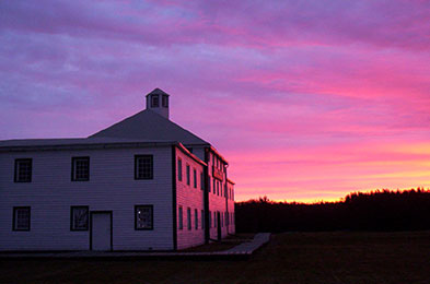
©Parks Canada Agency / Agence Parcs Canada, 2014
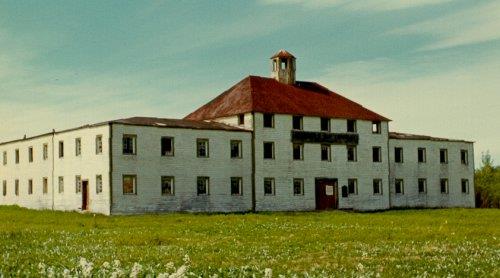
©Parks Canada Agency / Agence Parcs Canada, 1992 |
York Factory National Historic Site of Canada
York Factory, Manitoba
Hudson's Bay Company's principal fur trade depot from
1684-1870's.
York Factory National Historic Site is a 17th century fur trade post
built by the Hudson's Bay Company (HBC) near the mouth of the Hayes
River on Hudson Bay, 250 km southeast of Churchill, Manitoba. Surrounded
by marsh and boreal forest, this isolated 250-hectare site includes
ruins of the former Hudson's Bay compound now dominated by the company's
grand Depot building.
The heritage value of York Factory lies in the legibility of its
landscape and surviving resources as a major Hudson's Bay Company fur
trade post. Established in 1684 and briefly managed by the French from
1697 to1714, it had become the most important fur trade post on Hudson
Bay by 1730, and the major storage, manufacturing and distribution
centre for the company's many other posts in the northwest by the end of
the 18th century. During that time, York Factory existed in three
iterations. York Factory I (1684-1715) and York Factory II (1715-1788)
were situated on the north bank of the Hayes River and have disappeared
due to erosion of its banks. York Factory III (1788-1957), established
by Joseph Colen in 1788 on a higher land upstream from its predecessors,
is the compound that remains today. Consisting of over fifty buildings
at its peak in the 19th century, only two buildings, two ruins, and a
cemetery are now visible. York Factory closed as a fur trade post in
1957 and is now operated by Parks Canada as a national historic
site.
|
|