|
Park Summaries
Alberta
All text and photos are copyrighted by Parks Canada or the Canadian Register of Historic Places
(except as noted) and were extracted from either the Parks
Canada or Canada's Historic Places
Websites. Parks with a grey background are managed by Parks Canada.
©Parks Canada Agency / Agence Parcs Canada |
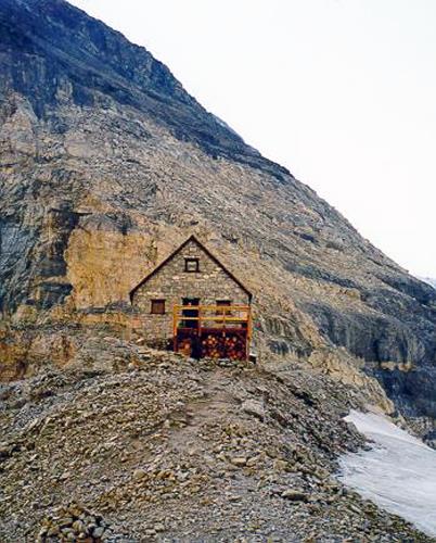
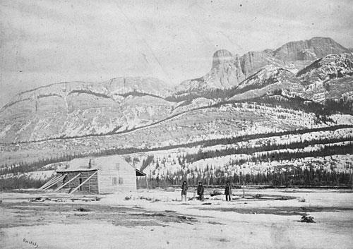
Abbot Pass Refuge Cabin National Historic Site of Canada
Banff National Park of Canada, Alberta
Early stone alpine cabin used by climbers, 1922
Abbot Pass Refuge Cabin is a high altitude alpine shelter in Abbot Pass,
a col between Mounts Lefroy and Victoria on the continental divide on
the border between Banff and Yoho National Parks. Its simple rectangular
form and unadorned stone construction speaks to the rigors of its high
altitude setting. The cabin is operated by the Alpine Club of Canada as
a shelter for mountaineers.
The heritage value of this site resides in its physical expression of
rustic design as well as in its traditional use by visitors to the park.
Built under the sponsorship of the Canadian Pacific Railway in 1922, it
was acquired by the Parks Branch in 1968 and restored in 1973. Since
1985, the hut has been maintained and operated by the Alpine Club of
Canada.
|
©Parks Canada Agency / Agence Parcs Canada, W. Wylie, 1998 |
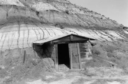
Atlas No. 3 Coal Mine National Historic Site of Canada
East Coulee, Alberta
Situated in the badlands of central Alberta, the Atlas No. 3 Coal Mine
National Historic Site of Canada is an exceptionally well-preserved
coal-mining landscape spread across the side of a bluff, on the south
side of the Red Deer River and over the valley immediately below. The
resources on the side of the hill are clustered around the vestigial
mine entrance and include foundations of a rotary dump, traces of a rail
line and trestle bridge leading east towards a second rotary dump, the
remains of that dump, two nearby explosives sheds, a blacksmith shop,
and a covered belt line leading down the hill. In the valley, the focal
point is the mine tipple and the related conveyor system leading to it
from the hill. A collection of wood frame service buildings is located
west of the tipple, consisting of a machine shop, storage building,
washhouse, and a loading ramp. East of the tipple, there are four former
managers' houses and a storage shed. The site contains rail beds and
some of the rails of the 1930 spur line that connected the Atlas mine to
the main line across the Red Deer River. Another striking feature is the
associated railway bridge, still extant.
The heritage value of the national historic site resides in the
surviving physical resources, which illustrate the former coal mining
operation at this location. Operational from 1936 to 1974, the site is
now presented to the public by the Atlas Coal Mine Historical
Society.
|
©Parks Canada Agency / Agence Parcs Canada, Jack Porter, 1998 |
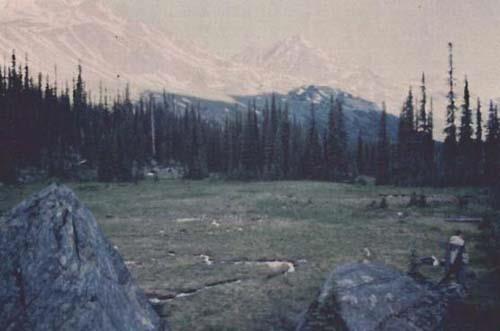
Athabasca Pass National Historic Site of Canada
Jasper National Park of Canada, Alberta
Major fur trade transportation route
Athabaska Pass National Historic Site of Canada is a route that crosses
the Rocky Mountains, the height of land that forms the Continental
Divide in western Canada. The pass forms a linear corridor of access
over these mountains in an area of dramatic landscape composed of river,
trail, trees, glaciers, lakes and rock formations. A geographic
composite of elements whose character alters with the seasons, the pass
becomes increasingly rugged as it ascends to meadows surrounding a small
glacial lake at the summit. Rivers to the west drain into the Pacific
while the eastern half drains into Hudson Bay. These mountains form the
boundary between British Columbia and Alberta and the site is situated
in both provinces. The Alberta side of the pass falls entirely within
Jasper National Park of Canada and is administered by Parks Canada. The
British Columbia side of the site is provincial crown land administered
by the British Columbia Ministry of Forests. The headwaters of the
Whirlpool River in Jasper National Park of Canada run through the pass
and eventually connect into the Columbia River.
Between 1811 and the mid-1850s, the Athabaska Pass played an important
role in the transportation routes of the fur trade of western North
America. Its importance derived from its strategic location on the
Continental Divide when traders, both British and American, were seeking
to extend their commercial activity west of the Rocky Mountains. David
Thompson, the noted surveyor and explorer, decided to search out a new
route in order to get around the blockade mounted by the Piegan Indians.
In January 1811, David Thompson, using traditional Aboriginal knowledge
and guided by Thomas the Iroquois, crossed the Rockies through this pass
and led his party down the Wood River to the place on the Columbia River
later called Boat Encampment. Journeying over the pass in 1824, Hudson's
Bay Company Governor George Simpson named the small lake at the top of
the pass "the Committee's Punch Bowl" — a reference to the London
Committee of the company. The Athabaska Pass route ensured continuity of
service to the fur trade posts already established by Thompson in the
upper and middle Columbia River Valley.
|

©Parks Canada Agency/ Agence Parks Canada, 2002 |
Áísínai'pi National Historic Site of Canada (Writing-on-Stone Provincial Park)
Milk River, Alberta
Áísínai'pi National Historic Site of Canada, also known as
Writing-on-Stone Provincial Park, is located on the Milk River in
southern Alberta 150 km east of the Rocky Mountains. Set in a region of
rolling mixed grass-prairie near the northern limits of the Great
Plains, the Milk River and its tributaries are deeply incised into the
surrounding grassland creating dramatic vertical sandstone cliffs above
and overlooking the river. The sandstone cliffs, caves and hoodoos are
the canvas for extensive rock art that consist of carvings (petroglyphs)
and paintings (pictographs) that commemorate vision quests and record
significant events of the Niitsítapi or Blackfoot from approximately
4000 BCE until the early 20th century. The site provides spectacular
views of the Poyíítahtai valley and the surrounding landscape.
Áísínai'pi ("it is pictured or written") represents one of the most
significant places in the cultural and sacred geography of the
Niitsítapi (Blackfoot people). Oral traditions describe the ancient
history and spirit powers found at Aísínai'pi. In addition, history and
sacredness are represented by numerous rock art images carved and
painted on the sandstone cliffs lining the Milk River. The rock art is
an expression of the meeting of the spiritual world and the physical
world. Most of the images date to the period before contact with
Europeans and are representational, depicting human, animal figures and
objects in an often schematic and highly conventionalized manner.
Images; static and ceremonial or active and biographic; include
shield-bearing warriors, deer, bison, antelope, birds and mythical
animals such as the Thunderbird. The images and motifs may be simple and
isolated or arranged across the surface in animated complex "scenes"
depicting ceremonies or battles. Later depictions include horses and
other datable objects of European origin. This visible and evocative
symbol of Aboriginal history is considered a sacred landscape intimately
related to the presence of Kátoyissiksi, a significant feature in the
sacred geography of the Niitsítapi. The dramatic sandstone cliffs and
formations that constitute the site are considered by the Niitsítapi to
host many powerful beings and have long provided an abundance of
important vision quest locations. Even though the rock art is an
important spiritual and cultural legacy, it is inseparable from the
broader cultural landscape of Áísínai'pi.
|
©Parks Canada Agency/ Agence Parks Canada, 2014 |
Banff National Park of Canada
Headquarters: Banff, Alberta
UNESCO World Heritage Site and Canada's first National Park of Canada (1885).
In the fall of 1883, three Canadian Pacific Railway construction workers
stumbled across a cave containing hot springs on the eastern slopes of
Alberta's Rocky Mountains. From that humble beginning was born Banff
National Park, Canada's first national park and the world's third.
Spanning 6,641 square kilometres (2,564 square miles) of valleys,
mountains, glaciers, forests, meadows and rivers, Banff National Park is
one of the world's premier destination spots.
|

©Parks Canada Agency/ Agence Parks Canada, 1985 |
Banff Park Museum National Historic Site of Canada
Banff National Park of Canada, Alberta
Early natural history museum in Rustic style, 1902-03
Banff Park Museum National Historic Site is a two-storey, rustic
log-faced building set prominently within a landscaped park in the Banff
townsite. The double-height interior space displays early botanical and
zoological exhibits from Banff National Park in early twentieth-century
glass cases.
The heritage value of Banff Park Museum resides in its setting,
architecture, and in the early (1891-1932) exhibits it houses. Banff
Park Museum was designed and built in 1902-03 as a combined museum and
Superintendent's Office for Banff National Park by engineer John Stocks.
Although the museum remained, other functions in the building changed
after 1936. Many of its original exhibits were declared surplus in the
1955-65 period. The building was rehabilitated in the 1980s and
1990s.
|

©Parks Canada Agency / Agence Parcs Canada |
Banff Springs Hotel National Historic Site of Canada
Banff, Alberta
The Banff Springs Hotel is a large, Chateau-style hotel, built between
1911 and 1928. It is picturesquely situated at the foot of Sulphur
Mountain in the town of Banff, within Banff National Park.
The Banff Springs Hotel was designated a national historic site in 1988
because it is a leading Canadian example of a large-scale, resort hotel
in a natural setting.
The Banff Springs Hotel is one of the largest and most renowned of the
resort hotels established by Canadian railway companies during the late
19th and early 20th centuries to encourage tourists to travel their
transcontinental routes. The hotel developed an international reputation
for excellence as a vacation retreat and became a symbol of tourism in
the Canadian Rockies. Its striking natural setting, Chateau-style design
and lavish interior decor appealed to a wealthy clientele seeking a
wilderness experience in opulent surroundings.
Built by the Canadian Pacific Railway (CPR), the Banff Springs Hotel
includes an eleven-storey tower designed by Walter S. Painter, added in
1911-14 to an earlier wooden structure, the main block of the hotel,
designed by J.W. Orrock, added in 1927-8 to replace the wooden structure
destroyed by fire, and various sympathetic additions added since 1969.
Architecturally, the Banff Springs Hotel differs from other railway
hotels in its more restrained use of the Chateau-style vocabulary, and a
greater reliance on Arts-and-Crafts finishes and forms, such as rough
stone masonry and rounded gables.
|
©Parks Canada Agency / Agence Parcs Canada, 2013 |
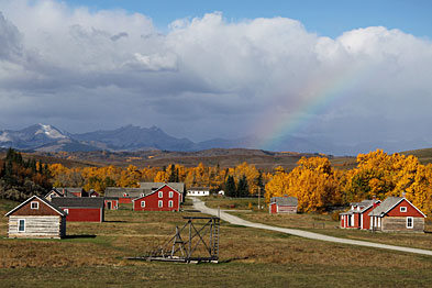
Bar U Ranch National Historic Site of Canada
Longview, Alberta
Historic ranch in Alberta foothills, 1883
Set in the rolling foothills of the Rockies, the Bar U Ranch is the only
National Historic Site to commemorate the history and importance of
ranching in Canada. The site has many historic buildings and structures,
illustrating various stages of ranching development, and is rich in
cultural landscape features. A visitor orientation centre and a vibrant
living history program interpret a time when the West was young.
Bar U Ranch National Historic Site of Canada comprises 148.43 hectares
of rangeland that constitute the original headquarters site of an
Alberta cattle ranch established in the 1880s. Located in a shallow
east-west valley along the banks of Pekisko Creek in southern Alberta's
foothills, the ranch includes rolling uplands, level flats, covered
creek bottoms and a variety of wooden ranch buildings.
The heritage value of Bar U Ranch National Historic Site of Canada lies
in the integrity of its cultural landscape as a representation of
Alberta ranching in the 1880-1950 period. It is embodied in the enduring
rural character of the landscape, in its continued use for cattle
raising, and in the traditional elements of the ranch landscape
associated with foothills cattle country, both natural and
man-made.
The Bar U Ranch was established in 1882, under the federal government's
grazing lease policy by the North-West Cattle Company, a firm of
investors led by Québec resident Fred Stimson. In 1902 it was acquired
by George Lane, a cowboy and former Bar-U foreman who had become a major
cattleman. He sold it to Patrick Burns in 1927, and it operated as part
of Burns' cattle conglomerate until 1949. The Bar U Ranch was in
continuous operation as a cattle ranch from 1883 until 1991. Since that
time, ranch activity has been guided by interpretive priorities rather
than those of the cattle industry.
|
©Lougheed House |
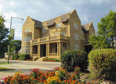
Beaulieu National Historic Site of Canada
Calgary, Alberta
Beaulieu National Historic Site of Canada consists of a large,
late-nineteenth-century residence situated on spacious open grounds
which span the eastern end of a city block in central Calgary.
Beaulieu was designated a national historic site of Canada because it is
apparently a lone, early survivor of an upper-middle class eclectic
mansion on the Canadian Prairies.
Beaulieu is a fine example of a home designed in an eclectic Victorian
style to accommodate the lifestyle and aspirations of an upper-middle
class Prairie family, that of the Honourable James Alexander Lougheed
and his wife, Isabella Clark Hardisty. Set within spacious, landscaped
grounds, the house illustrates the then-fashionable robust, eclectic
taste in design. Use of the finest materials and craftsmanship ensured
that Beaulieu was both a comfortable family home and a glamorous stage
for gatherings of Calgary's elite. As a rare survivor of this type of
mansion in the West, Beaulieu is a landmark on the Calgary
landscape.
|
©Parks Canada Agency / Agence Parcs Canada |
Blackfoot Crossing National Historic Site of Canada
Cluny, Alberta
Blackfoot Crossing National Historic Site of Canada is located at
Blackfoot Crossing, near Cluny, Alberta. The site includes the grassy
floodplain of the Bow River valley, south of the river known as Treaty
Flats on the reserve of the Siksika Nation, as well as the original
location of the ford over the Bow River (Blackfoot Crossing), the flood
plain, and terraces to the north of the ford. Within the boundaries of
the site there are numerous archaeological resources and historical
features including Crowfoot's grave, Earthlodge Village and Treaty No.7
Signing Site National Historic Sites of Canada and the campsite
locations of the five First Nations (Tsuu T'ina, Kainai, Siksika, Nakoda
and Peikuni) who signed Treaty No. 7.
Blackfoot Crossing, a ford on the Bow River, has been a focus of human
activity for many generations and a meeting place for many peoples and
aboriginal cultures. For this reason the site is of integral importance
to the traditions of the Siksika Nation. At the cultural and geographic
centre of traditional Blackfoot territory, it was one of the few places
where the Bow River could be forded safely. Consequently, it was the
site where representatives of the five First Nations of the Blackfoot
Confederacy (Tsuu T'ina, Kainai, Siksika, Nakoda and Peikuni) met
Canadian treaty commissioners in September 1877 to sign Treaty No. 7.
The site continues to be significant to the modern Siksika community as
the natural and cultural resources of Blackfoot Crossing bear witness to
a continuous history.
The rich variety of the archaeological resources at Blackfoot Crossing
reflects the long history of the site and its importance in the
traditions of the Siksika. The social and cultural values of the site
for the Siksika Nation are enhanced by the rich variety of the
archaeological resources that reflect the long history of Blackfoot
Crossing. The remains included medicine circles, boulder effigies,
cairns, buffalo and antelope jumps, Sundance sites, and tobacco planting
fields. Nearby are the earthworks of the Earthlodge Village built circa
1740 by an as yet unidentified Aboriginal people, which bears witness to
the interaction of different native cultures at the Crossing. In more
recent history, the grave of Crowfoot and his last campsite and the
monument to the Cree Chief Poundmaker are of especial importance to the
Siksika Nation. In addition, the sites of the first Oblate mission, a
whisky trading post, and an Indian Agency post, are evidence of more
recent interaction of native and white cultures.
|
©Parks Canada Agency / Agence Parcs Canada, Harry A. Tatro |
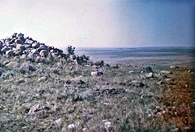
British Block Cairn National Historic Site of Canada
Suffield, Alberta
British Block Cairn National Historic Site of Canada, at the Canadian
Forces Base Suffield, 65 kilometres north of Medicine Hat, Alberta. Set
on a high knoll on open prairie, the site consists of a large boulder
cairn surrounded by a ring of stones, dating from around 1400 C.E.
Within this ring are numerous other rock arrangements, including brands
(rock arrangements in the shape of Latin alphabetic characters) and a
human effigy figure. Located outside of the ring is a group of tipi
rings, arranged in a rough arch shape, as well as numerous smaller
cairns, mounds, and individual tipi rings.
British Block Cairn is one of the best examples of a most striking site
type: a large boulder cairn. The site encompasses numerous rock
arrangements such as a boulder effigy, small cairns, clusters of tipi
rings and, of particular note, a large boulder cairn measuring 9 metres
in diameter and 2 metres in height. Set upon a high knoll, the site is a
landmark visible for 15 kilometres or more. A large seasonal lake is
found at the foot of the hill, which overlooks an extinct glacial
outwash system to the south and east. Excavations at the site have
yielded a considerable number of artifacts, including distinctive
specimens such as stone pipes and unique pottery forms. Digging also
suggests that there might have been a small burial pit at the centre of
the pile. According to archaeological findings, the construction of the
stone formations begins circa 1400 C.E., with additions being made a
various points since then. The potential spiritual significance of the
rocks and physical elements within the site are important for the
cultural heritage of the Niitsitapi on the western Canadian
plains.
|
©Parks Canada Agency / Agence Parcs Canada |
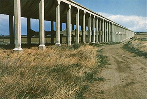
Brooks Aqueduct National Historic Site of Canada
Brooks, Alberta
The Brooks Aqueduct National Historic Site of Canada is located in a
shallow valley, five kilometres southeast of Brooks, Alberta. The Brooks
Aqueduct is an impressive reinforced concrete structure over 3.1
kilometres in length featuring a large flume mounted on 20-metre high
columns. The site also includes an inverted siphon, now filled to ground
level with lean concrete, that carried water under the Canadian Pacific
Railway (CPR) main line. Built by the CPR between 1912 and 1914 and
originally used to bring irrigation waters to semi-arid soils, the
reinforced concrete aqueduct is no longer in use.
The Brooks Aqueduct was constructed by the Canadian Pacific Railway
(CPR) between 1912 and 1914 as part of an extensive irrigation project
intended to make land in the south-eastern region of Alberta suitable
for farming. The aqueduct transported water from Lake Newell and the Bow
River across a shallow valley running north to south in order to
facilitate the irrigation of 55,000 hectares of land in the area east of
Brooks. The structure was a major engineering achievement, and features
a catenary-shaped flume mounted on 1,030 columns, and an inverted siphon
to carry water under the CPR main line. When the Brooks Aqueduct was
completed in 1914, it was the largest aqueduct of its type in the world,
reaching over 3.1 kilometres in length. Stresses on the concrete from
the freeze-thaw cycle, however, caused a deterioration of the aqueduct,
which required annual repairs. In 1979, sixty-five years after its
inauguration, a more efficient and larger capacity canal replaced the
aqueduct.
|
©Parks Canada Agency / Agence Parcs Canada, 2004 |
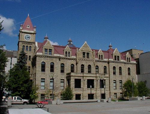
Calgary City Hall National Historic Site of Canada
Calgary, Alberta
The 1911 Calgary City Hall, a four-storey sandstone building with
central clock tower, is located on the corner of Macleod Trail and
Seventh Avenue in downtown Calgary. Currently used as the office of the
mayor and alderman, it is the architectural focal point of the City Hall
complex that consists of two later additions - the 1962 four-storey
brick extension to rear of the original building and the massive
wedge-shaped, mirrored-glass structure that was built in 1985 and known
as the Calgary Municipal Building. Its location on the eastern edge of
the Central Business District, across from Olympic Plaza and near the
terminus of Steven Avenue pedestrian Mall, forms the civic focal point
of the city.
Calgary City Hall is historically significant as an expression of the
intensely optimistic mood of the pre-World War I economic boom.
Officially opened in 1911, the City Hall was designed to address the
growing city's need for administrative space. Policing and related
services were located on the ground floor of the building, while
municipal services and city council occupied the remainder of the
building. Its design and finish was a bold declaration of the city's
progress to date and its faith in its potential for future
prosperity.
The Calgary City Hall was designed by architect William M. Dodd in the
Romanesque Revival style. The locally-quarried sandstone walls,
steeply-pitched tile roof, stone-gabled dormers, central clock tower,
and semi-circular arched main entrance are features characteristic of
this style and together they create an imposing structure that stands as
an architectural symbol of the high aspirations of the young
city.
|

©Parks Canada Agency / Agence Parcs Canada, K. Dahlin, 2002

©Parks Canada Agency / Agence Parcs Canada

©Parks Canada Agency / Agence Parcs Canada |
Cave and Basin National Historic Site of Canada
Banff National Park of Canada, Alberta
Hot springs, birthplace of national parks
The Cave and Basin National Historic Site of Canada commemorates the
birthplace of Canada's National Park system, which began here in 1885.
The growth and development of Canada's national parks are celebrated in
interactive displays and exhibits. Naturally occurring, warm mineral
springs can be found inside the cave, and outside in an emerald coloured
basin.
Cave and Basin National Historic Site of Canada is a hot spring located
in Banff National Park. The site was developed for public use with a
nearby swimming pool and bath-house and is now operated as a historic
site open to the public.
Cave and Basin was designated a national historic site of Canada because
it is the birthplace of Canada's national parks.
The heritage value of Cave and Basin National Historic Site of Canada
lies in the integrity and legibility of the cultural landscape that
developed around the hot springs. The mineral spring issues from Sulphur
Mountain where surface water penetrates the rock, absorbing minerals and
being heated by geothermal energy to emerge in a cave and in a nearby
basin before joining the bow river drainage system below. Long known to
local Aboriginal people, the site was found by non-Aboriginal people in
1859 and reserved for public use with the surrounding 16 square
kilometres in 1885. By 1887, development of this reserve had evolved
into Canada's first national park, the Rocky Mountain Park of
Canada.
|
©Parks Canada Agency / Agence Parcs Canada |
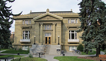
Central Memorial Library and Park National Historic Site of Canada
Calgary, Alberta
Central Memorial Library and Park, located just south of Calgary's downtown,
opened to the public in 1912 and reflect official efforts to create an
attractive and cultured new city in the west. The library is a handsome,
classically-inspired building with a massive portico and grand staircase. It
is one of the largest and most imposing of the 125 Carnegie libraries built
across Canada. Designed as a unit, the library and its surrounding park have
formed a social, cultural, educational, and memorial centre for Calgarians
for more than a century. Developed during Calgary's first major economic and
population boom at the turn of the 20th century, they illustrate the
confidence and optimism of the young city of Calgary.
The library was the project of a group of civic-minded, local women led by
Annie Davidson, recognized now as one of the city's cultural pioneers. This
group had advocated for the establishment of a free public library in Calgary
for years, arguing that it would help turn the booming western town into a
mature city. The library was funded in partnership with American businessman
and philanthropist Andrew Carnegie. A great believer in the importance of
free public libraries to communities, in the late 19th and early 20th century
Carnegie donated over $56 million to help build libraries worldwide. Of this
amount, $2.5 million funded 125 libraries in Canada, including three in
Alberta.
Like many Carnegie libraries, the design of Calgary Memorial Library is
classically-inspired with its grand columned entrance, rich and ornamental
exterior elements, and elegant interior. Upon opening, it quickly proved
popular with Calgarians from all walks of life. As the headquarters for
educational associations and various clubs, it became a cultural and
educational hub, even housing the city's first art show. It served as the
main library from 1912 until 1963, when it became a branch library and housed
the archives and research centre for the Glenbow Museum. It now serves as a
branch library and is home to the Muttart Art Gallery.
The park surrounding the library is a formally designed landscape which
includes a strictly symmetrical layout with elaborately designed beds, paths,
lawns, specimen planting, two decorative water fountains, and numerous
monuments and war memorials. It has evolved as a place of remembrance with
its significant collection of memorials and well-attended Remembrance Day
ceremonies.
|
©Parks Canada Agency / Agence Parcs Canada, L. Felske, 1998 |
Coleman National Historic Site of Canada
Crowsnest Pass, Alberta
Coleman National Historic Site of Canada is a small community situated
in the Crowsnest Pass, which is the major transportation route through
the southern Canadian Rockies. The distinctive character and layout of
the historic townsite is determined by a flat area of land bounded by
the Crowsnest River to the south, and the irregular line of the steeply
sided outcropping of rock to the north. The townsite itself is divided
through the middle by the Canadian Pacific Railroad (CPR) railway line,
which separates the mine site from the community areas on the north
side. The remnants of the historic mine site consist of a few service
buildings, some of which date from the first decades of the mine's
operation, a row of coke ovens and the massive steel-frame and metal
processing plant which dates from 1971. The main street of the town runs
parallel to the tracks and consists of a visually cohesive collection of
predominantly one- and two-storey buildings set flush to the property
line, but featuring a mix of roof shapes and materials that include
brick, wood-frame, stucco, and concrete. The street north of the main
commercial areas features a mix of institutional and residential
buildings, which include: the church high school, bank, fire hall, and
the original offices of the International Coal and Coke. West Coleman,
which is cut off from the rest of the town by an outcropping of rock,
forms a distinctive area within the townsite that is characterized by a
dense grouping of very modest, wood-framed miners' cottages set on
narrow lots with shallow setbacks.
The town of Coleman was founded in 1903 by the International Coal and
Coke Company which developed the adjacent mine site. Although
underground mining ceased around 1960, the surface plant continued to
process coal extracted from nearby open pit mines until 1983.
|

©Parks Canada Agency / Agence Parcs Canada, Gwyn Langemann, 2007 |
Earthlodge Village National Historic Site of Canada
Gleichen, Alberta
Earthlodge Village National Historic Site of Canada is a complex of
earthwork features located on a grassy flat on the north bank of the Bow
River near Cluny, Alberta. It consists of a semi-circular fortification
ditch 250 metres long and 2.5 metres wide. The ditch, terminated on the
east by an old dry channel of the Bow River, has changed shape due to
erosion and flooding. Behind the ditch are a series of eleven circular
"earthlodge" depressions encircling a large, central open area. The site
is set entirely within the Blackfoot Crossing National Historic Site of
Canada.
Despite its location in the heart of Blackfoot territory, Earthlodge
Village was built ca. 1740 by an unidentified people, possibly coming
from the middle Missouri River region in North and South Dakota. The
name "Earthlodge Village" refers to the Blackfoot name for the builders
of the site rather than the site's features. The eleven depressions
within the site are different in nature from the residential earthlodge
dwellings found in the middle Missouri River region, built by Siouan
speakers who lived in established villages often surrounded by ditches
and palisades, and whose houses were large timber frame structures
covered with sod or earth. In comparison, the features at Earthlodge
Village are far smaller in size than the residential structures, and the
wooden palisade instead ran inside the ring of depressions. Given the
placement of the palisade, it is believed that the pits were not
residential, but rather defensive in nature. As a fortified village, the
site is the only one of its kind in Canada, and is one of only two in
the North American Plains.
|
©Parks Canada Agency / Agence Parcs Canada |
Elk Island National Park of Canada
Headquarters: Fort Saskatchewan, Alberta
Alberta plains oasis for rare and endangered species.
Located less than an hour away from Edmonton, Elk Island National Park
of Canada protects the wilderness of the aspen parkland, one of the most
endangered habitats in Canada. This beautiful oasis is home to herds of
free roaming plains bison, wood bison, moose, deer, and elk. Also
boasting over 250 species of birds, the park is a bird watcher's
paradise. Be it for wildlife viewing, hiking, cross-country skiing,
picnicking or overnight camping, there is something for everyone at Elk
Island National Park.
Elk Park was first established in 1906 as a federal game preserve to
protect the declining elk populations of the Beaver Hills. Some of the
last Plains Bison in the world were reintroduced to Elk Park in 1907. In
1913 Elk Park joined the Parks Canada family. Since that time Elk Island
National Park has been Canada's source of disease free bison for
re-introduction and conservation initiatives throughout its former
range.
|

©Parks Canada Agency / Agence Parcs Canada, 1993 |
First Oil Well in Western Canada National Historic Site of Canada
Waterton Lakes National Park, Alberta
First commercially productive oil well in the West
First Oil Well in Western Canada National Historic Site of Canada is
located between Cameron Creek and Mile 5 of the Akamina Highway east of
the townsite of Waterton, Alberta. It consists of a well-head opening
and drill stem capped by a monument in the triangular shape of an oil
derrick.
The heritage value of the first oil well in western Canada lies in its
association with the western Canadian oil industry as illustrated by the
remains of this early well. Western Canada's first oil well was
discovered by John Lineham of the Rocky Mountain Development Co. in
1902. It had been drilling on the same site since 1901, and the oil was
encountered at 1024 ft. While this was a small well that ran dry in
1904, its location signaled the presence of much larger fields that were
later developed. Most of the visible remnants of the drilling operation
were removed when the monument was erected over the well in 1968.
|

©Parks Canada Agency / Agence Parcs Canada, 1989 |
Fort Assiniboine National Historic Site of Canada
Woodlands County, Alberta
Fort Assiniboine National Historic Site of Canada is located on the
banks of the Athabasca River in the community of Fort Assiniboine,
Alberta. The newly amalgamated Hudson's Bay Company built the fort in
1823 as part of a safer southern trading route connecting the
Saskatchewan and Athabasca River systems. There are no known above
ground remains of the fort.
Fort Assiniboine was built following the merger of the Hudson's Bay
Company and the North West Company in 1823. The fort was fortified, in
1825, after a road was completed between Fort Edmonton and Fort
Assiniboine, creating a safer and faster southern route connecting the
Saskatchewan and Athabasca river systems. It remained an important post
for a quarter century until the Hudson's Bay Company again changed its
shipping routes, excluding the fort. The scarcity of furs, the
centralization of company administration, and the security of the
Canadian-American frontier led to the abandonment of Fort Assiniboine in
1842. It was closed in 1877 and the abandoned shells of the buildings
were burned down a short time later.
|
©Parks Canada Agency / Agence Parcs Canada, 2011 |
Fort Augustus and Fort Edmonton National Historic Site of Canada
Fort Saskatchewan, Alberta
Fort Augustus and Fort Edmonton National Historic Site of Canada is
located on the north bank of the Saskatchewan River, 30 kilometres
north-east of Edmonton, Alberta. The site is composed of two late-18th
century forts: Fort Augustus, established by the North West Company from
1794 to 1795, and Fort Edmonton, established by the Hudson's Bay Company
in 1795. The forts sit almost immediately adjacent to each other in an
open field beside the river, marked by a Historic Sites and Monuments
Board of Canada plaque and cairn. There are no known above ground
remains of either fort.
The North West Company founded Fort Augustus in 1794 or 1795
approximately 1.5 kilometres upstream from the confluence of the
Sturgeon and Saskatchewan rivers. Fort Edmonton, originally called
Edmonton House, was founded by the Hudson's Bay Company in 1795 and is
located almost immediately adjacent to the North West Company post. The
North West Company and the Hudson's Bay Company were drawn to this area
in the late 18th century by the abundant fur resources along the river.
The histories of Fort Augustus and Fort Edmonton are inextricably
linked, as the two rival companies carried the flag and commerce of
Britain by way of the great rivers from the shores of the Atlantic Ocean
and Hudson Bay, to the Pacific and Arctic Oceans. After remaining at
their North Saskatchewan River location for six years, the forts were
abandoned in 1801 and moved approximately 30 kilometres upstream to what
is now the city of Edmonton. After relocating several times, the final
location of Fort Edmonton is designated as Fort Edmonton III National
Historic Site of Canada on the grounds of the Alberta
Legislature.
|
©Parks Canada Agency / Agence Parcs Canada, 2004 |
Fort Calgary National Historic Site of Canada
Calgary, Alberta
Fort Calgary National Historic Site of Canada is a square-shaped wooden
fort situated on the west bank of the Elbow River at its junction with
the Bow River. Located on the same site as the original fort, the
present structure is a reconstruction on a 12-hectare (40-acre) park
within the limits of Calgary, Alberta. Established in 1875 as Fort
Brisebois by the North West Mounted Police (NWMP), the fort included
men's quarters, a guard room, stables and storage facilities surrounded
by a palisade of vertical logs. The setting is a flat parcel of land
which slopes gently towards the river and which supports several large
trees.
Named by Assistant Commissioner James F. Macleod after his Scottish
ancestral home, Fort Calgary was a base for patrols to native
communities and ranches, and for police duties during the construction
of the C.P.R. railway. Rebuilt as a district headquarters in 1882, by
some seventy men of 'F' troop of the NWMP, the post was the focal point
for the new settlement of Calgary. Fort Calgary formed part of a network
of forts constructed across Canada that played an important role in the
extension and enforcement of federal law in Canada during the latter
part of the 19th century.
Fort Calgary served as a base for the NWMP forces. They were assigned
the task of enforcing federal law in the district and suppressing the
traffic of whiskey along the Bow River. Following the arrival of the
NWMP contingent in April 1875 a strategic site overlooking the rivers
was selected. Construction began in late summer and the fort was
completed within approximately six weeks. The fort's outer walls were
constructed of 3.5 metre pine logs floated from upstream and set in
trenches 1 metre deep.
|

©Parks Canada Agency / Agence Parcs Canada |
Fort Chipewyan National Historic Site of Canada
Wood Buffalo, Alberta
Fort Chipewyan National Historic Site of Canada is an archaeological
site located at Old Fort Point, south-east of the present-day town of
Fort Chipewyan, in Alberta. Established in 1788 as the centre of
northern trade, the fort sits atop a high rocky knoll overlooking Lake
Athabasca. The site includes archaeological vestiges such as two large
chimney piles, a large cellar pit, and four smaller pits.
The heritage value of Fort Chipewyan lies in its evocation of the
prosperous northern trade posts known under the same name. In 1788,
Roderick Mackenzie of the North West Company established Fort Chipewyan
at Old Fort Point on the south shore of Lake Athabasca. The abundant fur
resources in the area made the location optimal for a fur trading post.
By the early 19th century, however, ice breakage patterns of the lake,
the proximity of trade, and the dilapidated state of the fort prompted
John Finlay of the North West Company to relocate Fort Chipewyan two
times, about 32 kilometres (20 miles) north-west to the northern shore
of Lake Athabasca. The trading post quickly became the richest in North
America. Fort Chipewyan continued to play a major role in the fur trade
for over a century.
The heritage value of the first Fort Chipewyan also lies in its
association with Sir Alexander Mackenzie and his expeditions. It was a
starting point for Roderick Mackenzie's cousin Sir Alexander Mackenzie,
who led an expedition from the site down the Mackenzie River to the
Arctic in 1789. He also departed from Fort Chipewyan on his journey to
the Pacific in 1792-1793.
|

©Parks Canada Agency / Agence Parcs Canada |
Fort Dunvegan National Historic Site of Canada
Dunvegan, Alberta
Fort Dunvegan National Historic Site of Canada is situated in Alberta's
Peace River Valley in the town of Dunvegan, 27 kilometres south of
Fairview, Alberta. Situated on the northern shore of Peace River the
site consists of the remains of the fort established there in 1805 by
Archibald Norman McLeod as well as the modern-day interpretation centre.
Fort Dunvegan was a substantial trading post between 1805 and 1918. A
Historic Sites and Monuments Board of Canada plaque which was erected in
1951 stands in the vicinity of the original fort.
In 1804 the North West Company and the XY Company amalgamated and the
Northwest Company's uppermost fort on the Peace River, Fort Fork, was
abandoned; it was decided that a new fort would be established further
upriver. In 1805 Archibald Norman McLeod established the new North West
Company's Fort Dunvegan on the northern bank of the Peace River. Fort
Dunvegan was a substantial post including blockhouses and a magazine in
addition to houses for the master and men of the fort. The fort was also
the site of agricultural experiments carried out by Frederick Goedlike
and Reverend John Gough Brick. In 1821 the Hudson's Bay Company and the
North West Company amalgamated and Fort Dunvegan became a Hudson`s Bay
Company post. Hostilities with Aboriginal people in the area of the
Peace River Valley in 1823 resulted in the 1825 abandonment of the fort
by Chief Trader Hugh Faries. Fort Dunvegan was re-opened by Chief Trader
Colin Campbell three years later and continued to operate as a major
provision post until its closure in 1918.
|
©Topley Studio/Library and Archives Canada/PA-009240 |
Fort Edmonton III National Historic Site of Canada
Edmonton, Alberta
Fort Edmonton was the fur trade headquarters of the Hudson's Bay Company
for a vast territory that encompassed what is today southern and central
Alberta and south-eastern Saskatchewan. There were five Fort Edmonton
sites. The final 1831 edition was located on what is now the site of
Alberta's Provincial Legislature. Although dismantled in 1915, the City
of Edmonton operates a reconstructed fort at Fort Edmonton Park which
brings this period back to life. Join the costumed historical
interpreters and experience life as it was at the 1846 Hudson's Bay fort
and Cree Encampment. The Park also showcases Edmonton's history of 1885,
1905 and 1920, which are also interpreted through period streetscapes
and exciting programs for all ages.
|

©Canada Department of Mines and Technical Surveys / Library and Archives Canada, PA-020413, 1929 |
Fort Fork National Historic Site of Canada
Peace River, Alberta
Fort Fork National Historic Site of Canada is an archaeological site
located on the east bank of the Peace River, southwest of the Town of
Peace River, Alberta. It sits in a wooded area about ten kilometres
above the mouth of the Smoky River. There are no visible remains of the
fort associated with the first transcontinental journey of Alexander
Mackenzie.
The heritage value of Fort Fork resides in its historical associations
with the exploration of Canada, most notably by Alexander Mackenzie.
Constructed in 1792, Fort Fork was the North West Company's uppermost
post on the Peace River. In May 1793, Alexander Mackenzie wintered at
the fort before setting out on his historic transcontinental journey to
the Pacific. In the years following, Fort Fork was used as a provisional
post and was known among North West Company posts as being in good
condition with a garden and extensive living quarters. With the
amalgamation of the XY and the North West companies in 1804-05, Fort
Fork was replaced with Fort Dunvegan National Historic Site of Canada,
which was founded farther upriver.
|

©Parks Canada Agency / Agence Parcs Canada |
Fort Macleod National Historic Site of Canada
Fort Macleod, Alberta
Fort Macleod National Historic Site of Canada is located in what is now
the Town of Fort Macleod, approximately 150 kilometres south-east of
Calgary, Alberta. The site is situated at the western end of Macleod
Island, overlooking the Oldman River. The site is partly covered by
brush and by pasture and hay fields at its centre.
In 1874, the Assistant-Commissioner of the North West Mounted Police,
James F. Macleod, arrived on Macleod Island with a detachment of 150 men
and constructed the first Fort Macleod. Though the fort was relocated to
higher ground in 1883, the original Fort Macleod was the first North
West Mounted Police (N.W.M.P.) post in Southern Alberta, and served as
N.W.M.P. headquarters between 1874 and 1878. The fort enabled the
N.W.M.P. to institute and maintain the law, and to suppress the whiskey
trade. This helped gain the trust of the Blackfoot Confederacy,
contributing to the peaceful settlement of southern Alberta.
|

©Parks Canada Agency / Agence Parcs Canada, 2011 |
Fort Vermilion National Historic Site of Canada
Fort Vermilion, Alberta
Fort Vermilion National Historic Site of Canada is located on the
riverbank of the Peace River in the community of Fort Vermilion,
Alberta. The fort was moved to its current location between 1828 and
1831, from which it continued to operate until the mid-20th century. The
sole surviving component of the site is the Old Bay House, constructed
between 1906 and 1908, which is the only Hudson's Bay Company factor's
house on its original location in Alberta.
The heritage value of Fort Vermilion lies in its evocation of the fur
trade posts known under the name Fort Vermilion I and II, both located
in the Athabasca region. Until its amalgamation with the Hudson's Bay
Company in 1821, the North West Company, through a succession of trading
posts called Fort Vermilion, dominated the fur trade in the region. The
Beaver and other Dene peoples, and the Cree First Nation, supplied furs,
provisions, and leather for trade and company use west of the Rockies at
posts in New Caledonia.
In 1788, Charles Boyer built the first post, from which there are no
known remains, near Peace River to trade with the Beaver peoples.
Between 1828 and 1831, Fort Vermilion moved 90 kilometers to its current
location on the southern bank of the Peace River, where it formed the
nucleus of the village of Fort Vermilion. From this post, the newly
merged North West and Hudson's Bay Companies continued to operate into
the 20th century, aiding in the gradual evolution of the site from a fur
trade post to a settled community.
|
©Parks Canada Agency / Agence Parcs Canada, Trudy Cowan, 1989 |
Fort Whoop-Up National Historic Site of Canada
Lethbridge, Alberta
Fort Whoop-Up National Historic Site of Canada is located on a grassy
river valley terrace, near the confluence of the St. Mary and Oldman
rivers, just south of Lethbridge, Alberta. While there are no remaining
aboveground traces of the fort itself, a stone-lined well is visible and
low depressions in the ground indicate the original location of the
fort's cellar pits.
As a result of an 1832 United States law prohibiting the sale of whiskey
to Native Americans, two Montana traders, Albert B. Hamilton and John J.
Healy, traveled to Canada and established Fort Hamilton in 1869. This
"Whisky Fort" became a trading business that competed with the local
Hudson's Bay Company (HBC). Although the HBC sold many of the same goods
as Hamilton and Healy, including firearms, foodstuffs and textiles,
among other trade items, the HBC sold rum in place of whiskey. The sale
of whiskey and firearms from Fort Hamilton led to disorder among the
First Nations in the area, and the fort was renamed Fort Whoop-Up in
recognition of its reputation as one of the more dangerous and lawless
forts in the northwest. The attempt to establish law and order within
the region was one of the factors leading to the formation of the North
West Mounted Police (NWMP) in 1873.
In 1870, the original fort was destroyed in a fire. A second larger
fort, located further north of the original site replaced it. This
larger fort contained dwellings, a kitchen, a trade room, a blacksmith's
forge, and an infamous saloon that was the scene of several dangerous
incidents. Despite the violence, Fort Whoop-Up was an essential link in
the transportation of pelts and hides, and remained the headquarters of
trade between Canada and Montana until 1874 when the American traders
abandoned the fort. Following the departure of the Americans, the NWMP
used the site as an outpost of their Lethbridge detachment periodically
between 1876 and 1897. Eventually falling into disrepair, the fort was
badly damaged by fire in 1888, and was subsequently dismantled by local
settlers for scrap metal and lumber.
|
©Greg Melle, 2009 |
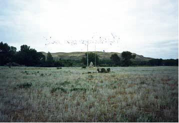
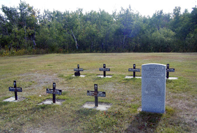
Frog Lake National Historic Site of Canada
Frog Lake, Alberta
Site of Cree uprising, Northwest Rebellion 1885
Just inside the Alberta border, the site of this tragic event is laden
with memories of lives lived and lost: archaeological remains, a
cemetery, and depressions in the earth representing the church, the
mill, the milk house, stables... remnants of old wagon trails still exist.
Frog Lake became a rallying cry for the Canadian Militia who were sent
west to deal with the rising conflicts. Frustrated with the Canadian
Government, especially the provision of food rations,
Kah-Paypamhchukwao, also known as Wandering Spirit, and other warriors
take control of Mishtahimaskwa's (also known as Big Bear's) Cree band
and come to Frog Lake to take up issues with the Indian Agent. Tension
erupts in the small settlement and nine people are killed and the rest
taken hostage. The deaths at Frog Lake drive the Canadian Government to
take a stronger law and order stance in the West.
Frog Lake National Historic Site of Canada is an archaeological and
historic site located in the community of Frog Lake, north-eastern
Alberta, near the Saskatchewan border. The site is associated with a
conflict that occurred between the Plains Cree and Canadian officials
during the 1885 North-West Resistance. There are no standing structures
on site however the settlement's remains are evident. Low rolling hills
and valleys, lakes and woods surround the site which is marked by an
HSMBC cairn and plaque.
The heritage value of Frog Lake National Historic Site of Canada lies in
its witness to the conflict as illustrated by those aspects of the site
associated with the event and its gestation period, namely the site's
location, unspoilt setting, and material disposition. The conflict,
formerly referred to as the Frog Lake Massacre, occurred on the site of
Farm Agency No. 15 established in 1879 to serve the neighbouring Wood
Cree reserves of Unipouheos and Puskiakiwenin around Frog Lake. This in
turn attracted a small non-Aboriginal settlement. In 1885, three years
after adhering to Treaty No. 6, a Plains Cree band led by Big Bear
(Mistahimaskwa) was encamped beside the agency. Deeply concerned for his
people's future, Big Bear — a leader of those clinging to traditional
values — still hoped to negotiate better terms, and held out from moving
onto a reserve. The government approach of limiting rations to encourage
settlement combined with a hard winter made conditions very difficult
for Big Bear's Cree followers. When news of Métis victories at Duck Lake
reached the camp, Big Bear's war chief, Wandering Spirit, responded to
the insufficient food supply and harsh labour conditions imposed by the
agency by leading an attack of Plains Cree warriors against it. Nine
settlers were killed in the ensuing conflict. The site where this attack
occurred has not been occupied since 2 April 1885, particularly because
the Frog Lake First Nation holds that the site of Big Bear's camp is
sacred and should not be disturbed. Frog Lake speaks to the point of
transition of local First Nations from the free hunting life of the
plains to the agricultural life of a reserve settlement.
|
©Parks Canada Agency / Agence Parcs Canada, Christine Boucher |
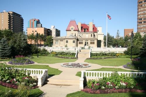
Government House National Historic Site of Canada
Edmonton, Alberta
Government House is on a low promontory overlooking the Saskatchewan
River in the Glenora area, a residential neighbourhood west of downtown
Edmonton that was developed in the first decades of the 20th century.
This building was constructed in 1912-13 on a large 28-acre property
acquired in 1910 by the Province of Alberta for use as the official
residence of the province's lieutenant governors. The property's
surroundings have changed considerably since the construction in 1968 of
the Provincial Museum of Alberta immediately north of the building.
There are now parking lots to the south and the west, as well as a
large, grass-covered, landscaped area that includes, among other things,
formal gardens, a fountain and a sculpture.
This impressive three-storey building was designed in accordance with
the plans of architect Richard P. Blakey, who was chief architect of
Public Works for the Province of Alberta from 1912 to 1923, under the
direction of Allan Merrick Jeffers, chief architect of the Alberta
Legislature Building (1907-13). Massive in appearance, it is made of
sandstone from Calgary: the stones, which vary in size, are laid
horizontally, while the trim and cornerstones are cut stone. It is
irregular in shape and has gabled roofs. The main façade, which faces
east, is uncompromisingly symmetrical. It has two large protruding
gables flanking a carriage entrance made up of classical columns and
pillars and topped by a balustraded balcony. The fairly simple
ornamentation is limited to crenels and escutcheons carved in stone. The
south façade is also imposing. It has a single large protruding gable to
which is joined a semicircular rotunda with rectangular windows grouped
together and topped with a crenel. A large covered gallery, whose
twinned classical columns support a balustraded balcony, runs along the
rest of this façade.
The main public spaces for receptions are on the ground floor. The
vestibule opens onto a spacious central hall around which the various
rooms are arranged: the former library and the music room on the left,
and the cloakrooms and current administrative offices on the right. The
large dining room, which was originally two rooms (the dining room and
the drawing room) is at the back. This floor, which has been restored,
still has some of its original elements, such as doors, cupboards, trim,
and panelling. On the second floor there is a rectangular receiving
area. The far end of this space opens onto a balcony, and a small
exhibit relating the history of the building has been set up on the
opposite side, with display cases containing a few photos and artifacts.
Five small meeting rooms surround this central space. The top floor, the
third, holds the Alberta Room, a spacious conference room.
|

© Jesse Pilkington, 2006 |
Head-Smashed-In Buffalo Jump National Historic Site of Canada
Municipal District of Willow Creek No. 26, Alberta
For much of the last 5700 years, Aboriginal people have driven bison to
their death over this cliff using a well-organized communal hunting
strategy. The result is the oldest, largest and best-preserved buffalo
jump known in North America. A complex of archaeological sites is
centred here, including ceremonial sites on the ridge, and an extensive
butchering area and campsite below the cliff. People took advantage of
the natural topography and prevailing winds to gather bison in the hills
to the west, and then funnel them through a series of drive lanes
several kilometres long towards the jump.
|
©Parks Canada Agency / Agence Parcs Canada, Dana Johnson, 1986 |
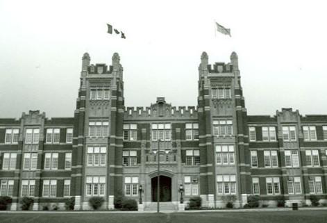
Heritage Hall — Southern Alberta Institute of Technology National Historic Site of Canada
Calgary, Alberta
Heritage Hall — Southern Alberta Institute of Technology National
Historic Site of Canada is a large, three-storey, early 20th-century
college building prominently situated on the brow of the Bow River
valley, which provides a panoramic view of downtown Calgary. Constructed
in the Collegiate Gothic style in red brick with sandstone trim, it
speaks to the growth of educational institutions in Canada in the early
20th century. The site is now part of a large institutional
campus.
Heritage Hall — Southern Alberta Institute of Technology is associated
with the growing need for a larger skilled workforce, which had become a
pressing challenge for Canadian educators and legislators during the
early 20th century. Alberta addressed this need at the post-secondary
level with the establishment of its Provincial Institute of Technology
and Art in 1916. One of three original buildings at the Institute,
Heritage Hall, was constructed between 1921 and 1922 to accommodate both
the Institute and the Calgary Normal School. Equipped with specialized
training facilities accommodated in an imposing Collegiate Gothic
structure, the Institute heralded the inception of advanced technical
education in this region of the country.
|

©Parks Canada Agency / Agence Parcs Canada |
Howse Pass National Historic Site of Canada
Banff National Park of Canada, Alberta
First crossed by David Thompson in 1807
Howse Pass National Historic Site of Canada is an early 19th-century
trans-mountain transportation route across the Rocky Mountains, in
western Canada. The pass extends through a striking mountain landscape
comprising a river, trail, trees, glaciers and lakes. The pass extends
from the confluence of the Howse River with the Saskatchewan River in
Banff National Park of Canada to the confluence of the Blaeberry River
with the Columbia River in British Columbia. The pass, intersected at
its eastern end by a modern highway development, extends across the
inter-provincial border between British Columbia and Alberta and falls
within both provinces. The Alberta side of the pass is situated within
Banff National Park of Canada and is administered by Parks Canada. The
British Columbia side of the site is provincial crown land administered
by the British Columbia Ministry of Forests.
The heritage value of this site resides in its significance as one of
the early trans-mountain routes to the Columbia River from the
Saskatchewan River Valley during the early 19th-century fur trade
period. The pass is also recognized as part of a traditional aboriginal
trade and hunting route and link. In 1807, David Thompson, the
experienced trader and cartographer, traversed the pass with a North
West Company party. The pass was named after Joseph Howse, the Hudson's
Bay Company employee who first crossed the pass through to the Columbia
River country in 1809 by way of reconnaissance. After 1810, having been
warned by the Pikani not to use this pass, Thompson sought a new
northern route, while John McDonald of Garth working for the Nor'westers
crossed in 1811. The actual period of use of the Howse Pass in fur trade
times was brief, being limited to the first decade of the
century.
|

©Parks Canada Agency / Agence Parcs Canada |
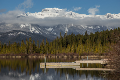
Jasper National Park of Canada
Headquarters: Jasper, Alberta
UNESCO World Heritage Site and glacial jewel of the Rockies.
Offering visitors a more laid-back mountain experience - with equal
options for adventure, discovery and relaxation. As one of Canada's
oldest and largest national parks, established in 1907, Jasper was once
seen as an island of civilization in a vast wilderness. More recently,
it has become a popular getaway from urban life, and a special place to
reconnect with nature.
With nearly 1000km of trails, thousands of campsites, wildlife beyond
measure and the second largest Dark Sky Preserve on the planet, there
are endless ways to enjoy the magic of Jasper National Park.
|
©Parks Canada Agency / Agence Parcs Canada |
Jasper House National Historic Site of Canada
Jasper National Park of Canada, Alberta
Archaeological remains of 1829 fur trade post, Hudson's Bay Company
Jasper House National Historic Site of Canada is a forest clearing
extending 110 metres along the Athabasca River to a depth of 150 metres
back from its banks, containing the remains of at least three buildings
from a former fur trade post, an associated cemetery, two historic
trails, and other archaeological remains. It is located on the west bank
of the upper Athabasca River, 1.4 kilometres north of Jasper Lake, on a
channelized alluvial fan that has, in part, acted as a dam.
The heritage value of Jasper House lies in its historical associations
with the fur trade routes across the Rocky Mountains as illustrated by
its location, setting and remnants of the associated community. This is
the second (1830-1857) site of Jasper House, a post established by the
Hudson's Bay Company on the eastern Pacific Slope in the early 19th
century. It was established as a staging post for brigades travelling to
the company's Columbia District trading posts through the Athabasca
Pass, and for a short time served as the connection and supply point
between east and west. It was a major destination for travellers using
the Athabasca and the Yellowhead passes and the First Nations route
through the Smoky River Pass.
|
©Parks Canada Agency / Agence Parcs Canada |
Jasper Park Information Centre National Historic Site of Canada
Jasper National Park of Canada, Alberta
Picturesque fieldstone park building of Rustic design, 1913-14
Jasper Park Information Centre National Historic Site of Canada is a
picturesque fieldstone residence (now information centre) set within a
treed park within the Jasper townsite. Its picturesque profile, with
steeply pitched roof and varied gables and porches, and its use of
natural materials such as rough fieldstone, log and wood, captures the
rustic aesthetic which became symbolic of early architecture within
Canada's national parks.
The heritage value of Jasper Park Information Centre lies in its
expression of the rustic design tradition that came to symbolize
Canada's national parks. Designed by Edmonton architect A.M. Calderon,
Jasper Park Information Centre was built in 1913-1914 as a landmark. The
park's first superintendent, S. Maynard Rogers, considered it an example
of the unified architectural theme he envisioned for construction of the
new Jasper townsite. Built as a mixed residence and administrative
space, it is now used as an information centre for the park.
|

©Parks Canada Agency / Agence Parcs Canada, 1994 |
Lac Ste. Anne Pilgrimage National Historic Site of Canada
Lac Ste. Anne County, Alberta
Lac Ste. Anne Pilgrimage National Historic Site of Canada is located on
the shore of Lac Ste. Anne, a broad, shallow lake in north-central
Alberta. The pilgrimage site is a flat piece of land that extends down
to the shores of the lake. The site consists of a landscape and a
portion of a lake. On the site is a small church, a rectory, and a
confessional building, Stations of the Cross, a cemetery and pilgrim
facilities including a store, food concession stands, and washroom and
shower buildings. On the right side, nearer the lake is the large,
pentagonal-shaped Saint Anne shrine with roof and open sides, while at
the lakes edge stands a gazebo where the blessing of the lake takes
place during the pilgrimage. Trees and shrubs border the eastern
boundary.
Lac Ste. Anne Pilgrimage, used by Aboriginal peoples in the pre-contact
period, became a pilgrimage site in 1889, managed by the Missionary
Oblates of Grandin Province. The pilgrimage continues on an annual basis
during the week of July 26th. People making the pilgrimage come from
across North America to step into the holy waters and be blessed by a
priest in the name of Saint Anne, the mother of the Virgin Mary.
|

©Parks Canada Agency / Agence Parcs Canada |
Leduc-Woodbend Oilfield National Historic Site of Canada
Leduc, Alberta
The Leduc-Woodbend Oilfield National Historic Site of Canada, located
north-west of Leduc, Alberta, in a rural landscape about 25 kilometres
south of Edmonton, is an upper Devonian dolomite oilfield made up of two
major pools of oil at different depths below the surface, namely D-2 and
D-3, and includes two other minor pools, Gilbert Blair and North
Woodbend A. Marking the site is an Historic Sites and Monuments Board of
Canada plaque located at the former Leduc No.1 oil well, outside the
Canadian Petroleum Discovery Centre.
The development of the Leduc-Woodbend Oilfield in 1947 marked a turning
point in the history of the Alberta petroleum industry. After the
drilling of Leduc No. 1, the geographical focus of the industry shifted
from Turner Valley northward to the central plains area, where vast oil
reserves were uncovered. Oil production, which had been in decline,
expanded dramatically and the Edmonton area became the main oil
refining, petrochemical, and distributing centre of the province. The
boom in output enabled Alberta to become a major oil producer for the
first time and permitted Canada to move toward petroleum
self-sufficiency.
|
©Parks Canada Agency / Agence Parcs Canada |
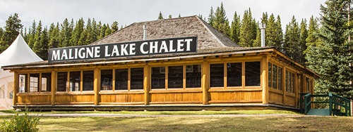
Maligne Lake Chalet and Guest House National Historic Site of Canada
Jasper National Park, Alberta
Surrounded by trees, the Chalet at Maligne Lake is located at the end of
Maligne Lake Road near the lakeshore. It is a rectangular,
single-storey, horizontal log construction with a hipped-gable roof. It
features an overhanging cornice supported on projecting logs, and a low,
closed verandah.
The Chalet is a Recognized Federal Heritage Building because of its
historical associations, and its architectural and environmental
values:
The Chalet is closely associated with the early history of Jasper and
the development of tourism within the park. An example of a building
designed as tourist accommodation it is also associated with Fred
Brewster, the businessman responsible for its construction.
The Chalet is a good example of a rustic structure that reflects the
aesthetics favoured by National Parks in the west during the early to
mid 20th century. It is a good functional structure built to reflect its
picturesque setting.
The Chalet maintains its unchanged relationship with its natural
surroundings and reinforces the Jasper Park setting. Conspicuous by its
elevated location, it is nonetheless compatible with the other buildings
at the site, all of which reflect the same standard Rustic aesthetic.
The Chalet is familiar to wardens and hikers within the park.
|
©Parks Canada Agency / Agence Parcs Canada |
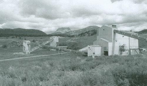
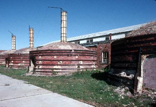
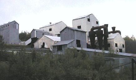
Medalta Potteries National Historic Site of Canada
Medicine Hat, Alberta
Medalta Potteries National Historic Site of Canada is a former
industrial ceramics manufacturing complex located in Medicine Hat,
Alberta. The site includes five interconnected brick and steel
industrial buildings dating from 1912 to the 1930s, four beehive kilns
(ca. 1920-1926), vestiges of five other buildings, a narrow-gauge rail
system, an internal road network, and in situ machinery. These resources
are distributed over an approximately 3.2 hectare property located on a
spur line of the Canadian Pacific Railway in the heart of an historic
industrial district that was an important centre for the clay products
industry in western Canada.
The Medalta Potteries National Historic Site of Canada illustrates the
evolution of ceramics manufacturing from 1912 to 1954. It is directly
associated with the history of the first plant on the site, the Medicine
Hat Pottery Company (1912-1916) and its subsequent owner Medalta
Stoneware Limited, which later became Medalta Potteries Ltd., operating
on the site from 1916 to 1954. The business was the most successful and
enduring manufacturing industry in Medicine Hat, the first western
Canadian manufacturer to ship goods east of the Great Lakes, and from
the 1920s to the 1940s, the largest manufacturer of pottery west of
Toronto. As such, it is the most extensive in situ resource associated
with the ceramic industry in Canada. The historic place includes
buildings and an industrial landscape that illustrate the organization
of the industry, its physical connection to national transportation
networks, its relationship to the community of Medicine Hat, the
manufacturing processes used in the production of pottery from 1916 to
1954, and the work environment.
|

©Parks Canada Agency / Agence Parcs Canada |
Medicine Hat Clay Industries National Historic Site of Canada
Medicine Hat, Alberta
The Medicine Hat Clay Industries National Historic Site is an extensive
industrial landscape situated in an area of Medicine Hat, Alberta known
as the North Flats. It includes features that illustrate the combination
of factors that led to Medicine Hat's emergence as the largest supplier
of clay products west of Ontario. Local clay beds, railway
transportation and a ready supply of natural gas to fire the kilns were
the key components that enabled a wide range of clay industries to
spring up along the 1.2 kilometre Canadian Pacific Railway spur line
that formed the spine of the clay industries district. The site's
landscape has a linear form comprised of three concentrations of clay
industry activity spread along the 1.2 kilometre. railway spur. Moving
from west to east, these concentrations are comprised of the former
Alberta Clay Products factory site and the adjacent Hycroft Pottery
site, the Medalta and National Porcelain Company sites, and the I-XL
property at the eastern end. Between these three concentrations are two
open areas comprised of fields and flood plain.
The heritage value of the Medicine Hat Clay Industries resides in the
ability of the evolved cultural landscape to provide tangible evidence
of the unique combination of factors that sustained the clay industries
in this location. During the first half of the 20th century, Medicine
Hat was the centre of the clay products industry in western Canada. The
establishment of the McCord Brickyard in the 1880s marked the start of
continuous brick manufacturing at this location. By 1907, early
brickyards were displaced by larger ventures, drawn to the Medicine Hat
Flats by municipal incentives, low-cost natural gas, direct access to
the CPR line via spur lines and reduced freight rates. Early important
manufacturers were Alberta Clay Products, Medicine Hat Brick and Tile
and Medicine Hat Pottery Company Ltd. (renamed Medalta Stoneware Ltd.
and then Medalta Potteries Ltd.). These three pre-1914 factories formed
the backbone of Medicine Hat's clay products industry and played an
important role in the boom period that shaped the character of western
Canada. They were augmented by two later factories: Medicine Hat
Potteries Ltd. (renamed Hycroft China Ltd.) and National Porcelain.
Collectively, the operational histories of these plants, as well as the
more modern I-XL plant, reveal the dynamics and complexities of the clay
industry in Canada.
|
©Parks Canada Agency / Agence Parcs Canada, 2004 |
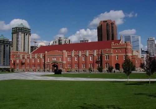
Mewata Drill Hall / Calgary Drill Hall National Historic Site of Canada
Calgary, Alberta
Mewata Drill Hall / Calgary Drill Hall National Historic Site of Canada
is a large, Tudor Revival style drill hall, located in Calgary, Alberta.
The size of the structure, its very complete facilities, and prominent
location all speak to the pride in which Canada's emerging military was
held at the time of its construction, and to the central role the
military was to play in Canadian history in the 20th century.
The Mewata Drill Hall / Calgary Drill Hall features elements of the
third phase of drill halls constructed in Canada, characterized by a
departure from the picturesque Romanesque Revival of earlier drill
halls, to a more monumental late mediaeval Tudor Revival style. The
reduction in superfluous ornamentation and the simplicity of composition
reflect a desire to impose discipline on architectural design, typical
of the third phase of drill hall construction in Canada.
The scale and bold design of the Mewata Drill Hall / Calgary Drill Hall
exemplify the wave of national pride that greeted Canada's strong
performance in the South African War. In western Canada, this military
enthusiasm led to a dramatic increase in militia enrolment and resulted
in the construction of new drill halls and armouries on an unprecedented
scale. The Mewata Drill Hall / Calgary Drill Hall, one of the largest
and most fully equipped of its type, was built in 1917-1918. For many
years it has been home to the King's Own Calgary Regiment and the
Calgary Highlanders, both of which were established in 1910.
|
©Parks Canada Agency / Agence Parcs Canada, L. Felske, 1999 |
Nordegg National Historic Site of Canada
Nordegg, Alberta
Nordegg National Historic Site of Canada is situated on a
heavily-forested hillside located in foothills of the Canadian Rockies
about 90 kilometres west of Rocky Mountain House National Historic Side
of Canada, in Alberta. The original mine entrance and surface plant form
a linear pattern spilling down the hillside, with two original mine
entries at the top, followed by series of smaller mine service buildings
and the remains of the plant power house. Below this service area is the
sprawling complex of steel-frame structures covered in metal sheeting
that made up the various parts of the 1951 coal processing plant. At the
bottom of the site are the coal loading facilities and the railway spur
line that carried the coal to markets.
The heritage value of the site resides in all those coal mining and
preparation related resources found within the defined boundaries of the
national historic site of Canada. The mine operated from 1911 to 1955
and was also associated with the expansion of the railway transportation
network during the early 20th century. It was financed through an
agreement in 1909 between the Canadian Northern Railway and a group of
German, Belgian and British investors lead by the German businessman,
Martin Nordegg, who also managed the mine.
|
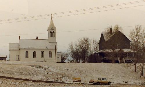
©Historic Sites Service, Alberta Culture and Multiculturalism, 1988 |
Notre Dame des Victoires / Lac La Biche Mission National Historic Site of Canada
Lac La Biche, Alberta
Notre Dame des Victoires / Lac La Biche Mission National Historic Site
of Canada is located on an isolated flat site surrounded by fields at
the southern end of Lac La Biche, 10 kilometres west of the town of Lac
La Biche, Alberta. It is composed of three principal mission buildings:
a rectory, a convent, and a church that is still actively used by the
community. There are also several outbuildings related to the farming
operations of the mission scattered across the property, including a
laundry, grain shed, chicken coop, outhouse and grist mill.
Established in 1853, Notre Dame des Victoires / Lac La Biche Mission
became one of the more important western Oblate missions by the 1870s.
Originally located near the Hudson's Bay Company trading post, the
mission was relocated in 1855 to its present site. Over the next decade
a series of simple log-framed buildings were built, including a church,
a rectory, a convent, a residential school and several farm buildings.
With the arrival of the Grey Nuns in 1862 and the use of local labour,
the mission was self-sufficient and flourishing by 1870, and began
serving local Cree and Dene converts, as well as the local Métis
population. An industrial school was opened at the mission in 1885, in
response to Dominion government policy, and by 1905 the convent building
was renovated to house a residential school. Throughout the life of the
Mission, most of the original buildings were rebuilt or underwent
important renovations, reflecting its historical character as an
isolated community where frequent renovations were key to its
survival.
Due to its geographical location, Notre Dame des Victoires / Lac La
Biche Mission became the hub of an important portage route which ran
overland from St. Boniface to the Mission and from the
Athabasca-Mackenzie river system to Fort Good Hope. The Mission was used
as a "trans-shipment" centre and warehouses were constructed for the
storage of goods to be shipped to the missions further north.
|
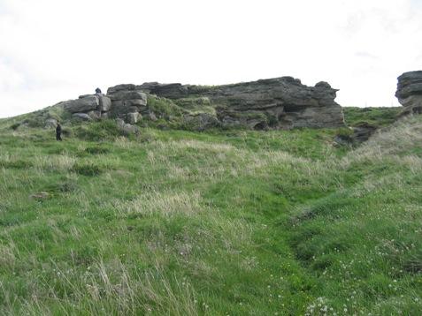
©Alberta Culture and Community Spirit, Historic Resources Management, 2004 |
Old Women's Buffalo Jump National Historic Site of Canada
Cayley, Alberta
The Women's Buffalo Jump archaeological site is located on the south
bank of Squaw Coulee about 3km northwest of Cayley. The site consists of
low sandstone cliffs creating a 6 to 7 metre drop to the slope deposits
below and bone beds representing the remains of numerous bison driving,
killing, and processing events, which extend to the bottom of the valley
of Squaw Coulee. The slope deposits provide evidence of site use dating
from the Late Middle Prehistoric Period (ca. 2700-1500 years ago) into
the Late Prehistoric Period (ca. 1500 to 250 years ago). Artifacts
collected from this site are stored in the Royal Alberta Museum.
The heritage value of the Women's Buffalo Jump archaeological site lies
in the fact that its multiple bone bed deposits represent a
well-preserved and clearly identifiable Aboriginal land use pattern that
occurred in the Rocky Mountain Foothills over the last two millennia.
Rapid and frequent burial of continuous cultural occupations by slope
erosion has resulted in excellent preservation of up to 30 discrete
cultural layers. These deposits represent the Middle Prehistoric Period,
including layers 17 to 28 with Pelican Lake Phase (ca. 2700-2000 BP)
materials and layers 15 to 21 with Besant Phase (2000 BP to 1500 BP)
material, as well as the Late Prehistoric Period (ca. 1500-250 years
ago), including a minimal amount of Avonlea Phase (ca. 1300 years ago)
material and layers 1 to 13 containing Old Women's Phase (ca. 1300-250
years ago) materials. Among buffalo jump kill sites in Alberta, few are
so well stratified or contain well-preserved materials in such quantity.
In addition, the site is believed to be the origin location for the
Blackfoot legend that describes the first marriage between men and
women, and features the deity Napi as a central figure.
|

©Parks Canada Agency / Agence Parcs Canada, 2004 |
Palace Theatre National Historic Site of Canada
Calgary, Alberta
The Palace Theatre National Historic Site of Canada is an
early-20th-century movie theatre located in the heart of the business
district of Calgary, Alberta. One of only four movie "palaces" still
standing in western Canada, the theatre is distinguished by its large
scale and its elegant exterior façade with neoclassical detailing. Set
within the historic Stephen Avenue Mall, this theatre demonstrates the
varied culture and history of Calgary.
The Palace Theatre is one of three surviving Canadian examples of
architect Howard C. Crane's work, and is a good example of an early
phase of his international work. It typifies the Canadian cinemas
designed by Crane for the Allen theatre chain. Classical details of the
elegant exterior façade and luxurious interior are characteristic of
Crane's palace theatres, although each theatre exhibits unique
variations, such as the Palace Theatre's pedimented rectangular windows
and added lounge space inside.
The Palace Theatre is one of four surviving movie theatres in Canada
built by the Allen brothers, Jay and Jule, and their father Bernard.
During the early 20th century, the Allen family ran the biggest cinema
chain in Canada, one of the largest in the world. One of the last
theatres to be built by the Allen family in Canada, the Palace Theatre
represents the impact of the Allen cinema chain on Canadian life and its
contribution to the Canadian film industry. By promoting movies and
movie going, and by erecting large, opulent movie palaces across the
country, the Allen family helped to elevate movies to a form of
reputable, accessible and affordable entertainment.
The Palace Theatre fulfilled an important role in the cultural life of
Calgary by providing an elegant setting for a wide variety of films and
live entertainment. The Allens' were strong promoters of Canadian
content and provided a venue for artists to share their talent, which
included being the first home of the Calgary Philharmonic Orchestra.
Typical of other movie palaces of the day, its early programs were
varied, and included organ recitals, orchestral selections and even
variety shows.
The Palace is historically associated with early radio in Alberta, and
was the original home of William "Bible Bill" Aberhart's radiobroadcasts
on religious themes, recorded with a live audience. Beginning in 1925,
Aberhart used the broadcasts to disseminate his religious and political
ideas, leading to the founding of the Social Credit party, and to
Aberhart's election as Alberta premier (1935-1943).
|
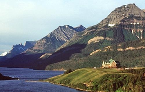
©Parks Canada Agency / Agence Parcs Canada, J.F. Bergeron. 1999 |
Prince of Wales Hotel National Historic Site of Canada
Waterton Park, Alberta
The Prince of Wales Hotel is a large hotel, designed in a Swiss-chalet
style. It is picturesquely situated on a promontory overlooking Waterton
Lake and the town site of Waterton Lakes National Park.
The Prince of Wales Hotel was designated a national historic site in
1992 because it is constructed in the Rustic Design tradition and it is
associated with tourism development in the national parks.
Built in Waterton Lakes National Park by the Great Northern Railway
(GNR) as the only Canadian link to a network of American park resorts,
the Prince of Wales follows the Swiss-chalet theme established for GNR
resorts. The design theme extended the bold Rustic aesthetic used in
Canada's national parks during the early 20th century.
Built in 1926-7, the Prince of Wales Hotel represents the golden age of
railway resort development in Canada. The construction of a large hotel
was considered vital to the success of the national park as a tourist
destination. The hotel functions as the pre-eminent resort facility
within the park. The hotel's striking design and spectacular setting
make it a landmark and symbol of Waterton Lakes National Park.
|
©Parks Canada Agency / Agence Parcs Canada, J. Cousineau |
Reader Rock Garden National Historic Site of Canada
Calgary, Alberta
Established in 1913 and developed until 1942, this garden is a showcase for
the horticultural, ecological, and aesthetic possibilities of gardening in
the harsh climate of Calgary. Its creation demonstrates the need to
illustrate the potential of gardening in Western Canada. In its heyday, it
was regarded as one of the most beautiful and successful gardens in Western
Canada, combining the informal aesthetics of the Edwardian Arts and Crafts
movement with the structure and content of the highly popular alpine rock
garden typology. Its founder, William Roland Reader, was one of a small
number of municipal parks superintendents in Canada who significantly shaped
the open space systems of their cities through professional skill and
knowledge, personal energy, dedication, and long-service. This garden
supported horticultural work in the larger urban parks system, including the
adjacent cemeteries developed by Reader.
Reader Rock Garden is built into a steep hillside south of downtown Calgary.
It is an Arts and Crafts style alpine rockery, a garden type popular in
Europe and North America at the beginning of the 20th century. Rock gardens
of this type feature naturalism, informality, hardy plant species, and
microscopic alpine settings within the garden. Reader Rock Garden consists of
a matrix of rock paths, steps, and walls that form numerous planting beds
divided into sections containing thousands of native and non-native plant
specimens.
Although the century-old garden can be appreciated for the beauty of its
plantings and the ingenuity of its design, it is also interesting as an
example of how the horticultural possibilities of the Canadian Prairies were
promoted when European settlement in Western Canada was in its infancy.
Reader created one of the few significant gardens in Western Canada in an
environment believed to be hostile to agricultural endeavour. Undaunted by
desert-like conditions, chinook winds, and extremes of temperature, his
personal garden became not only a vehicle for promoting settlement but also a
successful experiment in civic beautification. Taking inspiration from the
City Beautiful movement, which linked civic beauty with social progress, as
well as Thomas Mawson's garden-city plan for Calgary, Reader worked
tirelessly to advance the City Beautiful principles he believed would draw
settlers to the region. Species cultivated successfully in Reader's garden
and propagated in his nurseries were planted throughout Calgary as part of
the Calgary Parks' mission. Private citizens were encouraged to follow
Reader's example, having also been invited to visit his garden and take
inspiration from it.
To the extent that trees, parks, and gardens of all kinds can be seen to
flourish in southern Alberta, they owe a significant debt to the
horticultural achievements of William Roland Reader, the fruits of which can
be enjoyed in the Reader Rock Garden today.
|
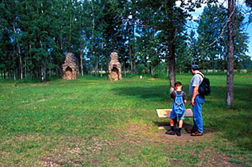
©Parks Canada Agency / Agence Parcs Canada, K. Dahlin, 2002 |
Rocky Mountain House National Historic Site of Canada
Rocky Mountain House, Alberta
Rival Hudson's Bay Company and North West Company posts
Rocky Mountain House...the forts are gone but the name remains. This is a
story of trade, exploration and competition, but above all it is a story
of people!
In 1799 the North West and Hudson's Bay companies set up rival posts at
the end of the fur trade line on the North Saskatchewan River.
Competition for trade was fierce at Rocky Mountain House, and during its
76-year history, nine different Aboriginal cultures came here to trade.
Explorer, fur trader and mapmaker, David Thompson used the North West
Company post as a base for finding a pass across the Rocky
Mountains.
Today, Parks Canada protects the archaeological remains of four trading
posts while presenting the site's history.
Rocky Mountain House National Historic Site of Canada is an
archaeological site that contains the remains of several early
19th-century fur trade forts known as Rocky Mountain House. It is
located on the North Saskatchewan River at Brierly Rapids, which was
historically an obstacle to navigation. The designation refers to the
remains of trading establishments built and occupied between 1799 and
1875 on the west bank of the North Saskatchewan River above its
confluence with the Clearwater River together with an associated burying
ground.
The heritage value of Rocky Mountain House lies in its historical
associations as illustrated by its setting and archaeological remains.
Rocky Mountain House was established by the Northwest Company in 1799 on
a site frequented by the Blackfoot people, and close to Acton House,
established nearby by the Hudson's Bay Company at the same time. It
served initially as a post on the transcontinental route, then as a fur
trade and provisioning post and boat-building operation, then as the
focal point of the Hudson's Bay Company's strategy towards the American
competitors on the Missouri River. Its occupation was not continuous
during the fur trade, and posts were rebuilt and replaced over the years
using at least four different sites (1799-1821, 1835-1861, 1868-1875 and
the site of Acton House, 1799-1835, respectively). After 1875 there was
no permanent occupation of the site.
|

©Parks Canada Agency / Agence Parcs Canada, 2005 |
Rundle's Mission National Historic Site of Canada
Pigeon Lake, Alberta
Rundle's Mission National Historic Site of Canada is located on the
north shore of Pigeon Lake, in Alberta. Associated with Reverend Robert
Terrill Rundle, the Wesleyan chaplain to the Hudson's Bay Company, the
site was selected in 1847 for the establishment of a permanent mission.
While there are no visible resources of the original mission,
archaeological testing has revealed evidence associated with early
mission buildings, including remains of houses, an artesian well and
possible pre-contact resources.
In 1840, Reverend Robert Terrill Rundle was one of four Wesleyan
Methodists invited by the Governor of the Hudson's Bay Company to
establish missions in Rupert's Land. When Rundle arrived at Edmonton, he
was the first missionary of any faith to serve in the prairie region
between the Pacific Ocean and Norway House, in Manitoba.
Reverend Rundle traveled extensively throughout the area for several
years before attempting to establish a permanent mission. In 1847, he
selected a site on Pigeon Lake that became the first Protestant mission
in the prairies. After Rundle was forced to leave the west due to ill
health, responsibility for developing the site, known as 'Mission
Beach,' belonged to Benjamin Sinclair, a lay preacher, and his wife, who
managed the mission for the next few years until leaving for Notre Dame
des Victoires / Lac La Biche Mission. The mission was briefly
re-established in the mid-1850s, but was unsuccessful until almost a
decade later when a permanent mission was created by John and Abigail
McDougall, which operated until 1906.
|

©Parks Canada Agency / Agence Parcs Canada |
Skoki Ski Lodge National Historic Site of Canada, 1965
Banff National Park of Canada, Alberta
Ski lodge in rustic vernacular, 1930-31.
The Skoki Ski Lodge is a backcountry ski lodge facility built during the
1930s. It is located on the banks of Little Pipestone Creek, in the
Skoki Valley north of Lake Louise, in the mountains of Banff National
Park. The facility comprises six buildings and their surrounding
landscape, linked by a system of trails and footpaths. The built
heritage includes: the main lodge (1930-6), the Honeymoon cabin (1932),
the Wolverine cabin (1932), the Creek cabin (1936), the bunkhouse
(1936), and the former bathhouse (1936).
The Skoki Ski Lodge was designated a national historic site in 1992
because it is constructed in the Rustic Design tradition and it is
associated with tourism development and outdoor recreation in the
national park.
Skoki Lodge is a rare and well-preserved illustration of the early
visual identity of the mountain parks and of the early days of skiing
and ski tourism in Banff National Park. Built by a group of local ski
pioneers as a destination for backcountry ski tourists, it was the first
such facility to operate on a commercial basis in Canada. The six
buildings comprising the site are excellent examples of the log building
tradition associated with Banff National Park. The use of local
materials is consistent with the Rustic Design tradition established for
national parks.
The site was built and operated by The Ski Club of the Canadian Rockies
under the leadership of ski pioneer Cliff Whyte. It was managed during
the early years by local artists and philanthropists Peter and Catharine
Whyte and expanded in 1935-6 by manager Jim Boyce.
|
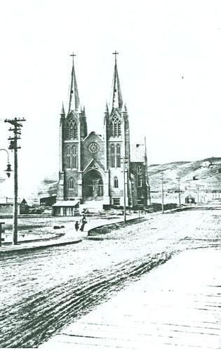
©Parks Canada Agency / Agence Parcs Canada, 1914 |
St. Patrick's Roman Catholic Church National Historic Site of Canada
Medicine Hat, Alberta
St. Patrick's Roman Catholic Church National Historic Site of Canada is
located on a large lot near the bridge crossing of the South
Saskatchewan River to downtown Medicine Hat. Constructed between 1912
and 1914, this church is distinguished by its soaring twin spires,
pinnacles, and recessed arched entranceway, all executed in pale, smooth
concrete. Designed according to a cruciform plan, the church is
connected to the modern rectory of St. Patrick's parish.
Completed in 1914, St Patrick's was designed by American architect
Manley N. Cutter, using reinforced concrete. Through the use of modern
materials and the relatively severe and planar quality of the building,
St. Patrick's represents a marriage of an early twentieth-century
aesthetic with French Gothic Revival details. Featuring twin towers
topped by polygonal spires, a recessed pointed-arch entranceway, arched
stained glass windows, and rose windows, St. Patrick's represents a fine
example of the Gothic Revival style, adapted with modern construction
methods and materials. Major additions such as the hammer beam ceiling,
installed between 1931 and 1932, the rose windows on the east and west
transepts, added in 1955, and the copper exterior roofing, added in 1977
to prevent the leaking of the original concrete roof, are sympathetic to
the original design.
|

©Sean Marshall, May 2011 |
Stephen Avenue National Historic Site of Canada
Calgary, Alberta
Stephen Avenue National Historic Site of Canada is a historic district
in downtown Calgary, also known as Old Stephen Avenue. It consist of
nearly three dozen commercial buildings from the 1880-1930 era (known as
the Sandstone Era), mostly retail properties, with several former banks
and one church.
The heritage value of Stephen Avenue resides in its distinctive
character as a late-nineteenth-century retail streetscape in a growing
prairie urban centre.
|
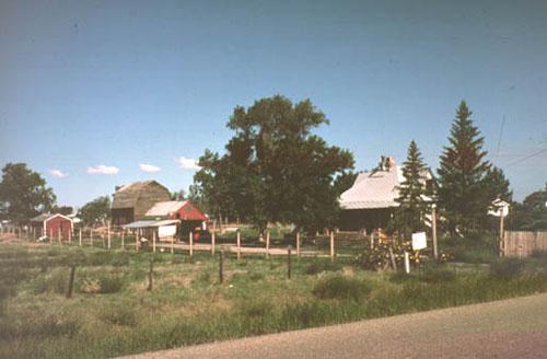
©Parks Canada Agency / Agence Parcs Canada |
Stirling Agricultural Village National Historic Site of Canada
Stirling, Alberta
Stirling Agricultural Village occupies one-square mile (260 hectares) of
land in the heart of the short-grass prairie of southern Alberta,
appearing as an oasis of trees and farmsteads amid a flat, open
landscape. The one-section plat is laid out in a regular grid of wide
streets with each ten-acre (4.1 hectares) block divided into large lots
with widely spaced, wood-frame houses, agricultural outbuildings,
gardens and animal pens. The village also includes a commercial area, a
school and a church.
Stirling Agricultural Village was designated a national historic site of
Canada because it is the best surviving example of a Mormon agricultural
village.
The heritage value of the village resides in its illustration of a
typical Mormon settlement form from the turn of the twentieth century.
It was introduced to southern Alberta by members of the Church of Jesus
Christ of Latter-day Saints who settled in this region during the Great
Wheat Boom era from the late 1890s to 1914. The village of Stirling was
founded in 1899 through a partnership between the Alberta Railway and
Irrigation Company and the LDS Church to bring American immigrants to
build an irrigation canal and found two villages, Stirling and
Cardston.
|
|
Suffield Tipi Rings National Historic Site of Canada
Cypress County, Alberta
The Suffield Tipi Rings National Historic Site of Canada is located on
rolling hills overlooking the South Saskatchewan River, in Alberta. The
site encompasses 14 sets of archaeological remains relating to the
cultural occupations of Plains First Nations peoples, featuring tipi
rings, medicine wheels and various other rock arrangements. The tipi
rings are located on the uppermost terraces above the river level and
just below the level of the adjacent prairie to the west, while the rest
of the petroforms are distributed across a large expanse of open land
and alongside the river.
The numerous archaeological sites at the Suffield Tipi Rings are set
within Canadian Forces Base (CFB) Suffield, and cover more than 450
square kilometres. The site features fine examples of rock formations
created by Plains First Nations, including numerous tipi rings, medicine
wheels, small cairns, and linear boulder alignments. These rock
formations are linked with habitations and ceremonies of the Plains
First Nations, and have been dated to 1430. Tipi rings and boulder
features were once common on the plains, but steady urban and industrial
development along with intensive farming has eradicated them in most
areas.
|

©Parks Canada Agency / Agence Parcs Canada, K. Dahlin, 2002 |
Sulphur Mountain Cosmic Ray Station National Historic Site of Canada
Banff National Park of Canada, Alberta
Remains of high altitude geophysical laboratory
Sulphur Mountain Cosmic Ray Station National Historic Site of Canada is
the site of a former laboratory located near the summit of Sulphur
Mountain, in Banff National Park of Canada. The remaining concrete
foundation is accessible only by foot.
The heritage value of Sulphur Mountain Cosmic Ray Station lies in its
location, the legibility of its remains, and their association with an
important worldwide scientific phenomenon. The Sulphur Mountain Cosmic
Ray Station was one of nine Canadian monitoring stations built in
1956-57 to meet Canada's commitment to the International Geophysical
Year of 1957-58 organized by the International Council of Scientific
Unions. Situated at an altitude of 2383 metres, it became Canada's most
important cosmic ray observatory, contributing to our understanding of
how the sun effects the earth's environment. Its sponsor and initial
occupant was the National Research Council of Canada, although the
University of Calgary assumed operation of the laboratory from
1960-1978. During this period, the size of the original building was
expanded to accommodate an upgrade of its monitoring equipment. Once the
station closed, both the building and its equipment were removed in
1981.
|

©Parks Canada Agency / Agence Parcs Canada, 1992 |
Temple of the Church of Jesus Christ of Latter Day Saints National Historic Site of Canada
Cardston, Alberta
The Temple of the Church of Jesus Christ of Latter Day Saints National
Historic Site of Canada in Cardston, Alberta, is a monumental granite
building sited on a rise in the middle of a large, landscaped site, set
against the dramatic backdrop of Chief Mountain. The building's severe,
interlocking geometric shapes ascend in a pyramidal shape, evocative of
Pre-Columbian architecture. Located in the heart of the town, both
geographically and spiritually, the temple continues to serve its
religious function.
The Temple of the Church of Jesus Christ of Latter Day Saints was
designated a national historic site of Canada in 1992 because: the
building is constructed in the finest of materials and exhibits an
exceptional level of craftsmanship; it is a striking modern building
dominating Canada's first Mormon settlement.
The temple is a striking example of modern building design in the
Prairie School style of Frank Lloyd Wright. Designed by the American
architects from Salt Lake City, Hyrum Pope and Harold Burton, the
building is a radical departure from other Mormon temple designs. The
exterior, mainly the work of Pope, is reminiscent of Wright's Unity
Temple in its strong horizontal lines with contrasting vertical
emphasis. The same aesthetic informs the interior designed by Harold
Burton. Utilization of Prairie School architectural motifs and the
building's monumentality reflect both architects' desire to achieve a
unity of both "modern and ancient" in the building design.
The Temple of the Church of Jesus Christ of Latter Day Saints is also
notable for its use of high quality materials and its exceptional level
of craftsmanship. Pope and Burton were followers of the Arts and Crafts
movement which strove for continuity of design from exterior structure
to interior detailing and furnishing. The high quality execution of the
interior features is evident in the craftsmanship seen in inlaid and
paneled hardwoods, interior furnishings and light fixtures. Although
construction started in 1913, it was not until 1923, when the interior
finishes and artwork had been completed, that the building was
consecrated.
The temple sits on a landscaped square at the town's centre. In the
1950s, an early wooden tabernacle that shared the site was demolished
and the area was landscaped to give the grounds a more open appearance.
Closure of an existing road allowed the erection of a new temple-fronted
courtyard and visitor centre, which both blend with the original
architecture. Over the years other additions have included a small area
on the east side as well as the redecoration and modernization of
interior spaces.
|
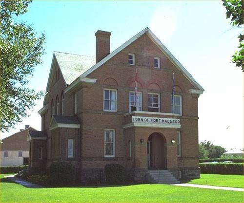
©Parks Canada Agency / Agence Parcs Canada, 1987 |
Territorial Court House National Historic Site of Canada
Fort Macleod, Alberta
The Territorial Court House National Historic Site of Canada is situated
in Fort Macleod in southern Alberta. Built of red brick and trimmed with
sandstone, the former court house is a two-and-a-half-storey building of
domestic appearance with a rectangular footprint. The cross-gabled
design features large, arched windows, returned eaves and projecting
porches. Although the building has been converted to house the town's
municipal offices, the interior still retains some of the original
features and finishes.
The Territorial Court House served as the seat of justice for southern
Alberta for 67 years. Between 1888 and 1905 the Government of Canada
built a dozen court houses to serve the new settlements of the prairies.
Most of these buildings were phased out of service and eventually
demolished following the implementation of provincial court systems in
Saskatchewan and Alberta in 1907, but the Court House at Fort McLeod was
an exception. Completed in 1904 as a territorial court house, it
remained in use until 1971. The Territorial Court House was one of three
constructed from a standard plan produced by the federal Department of
Public Works under the direction of Chief Architect D. Ewart.
|

©Parks Canada Agency / Agence Parcs Canada |
Treaty Nº 7 Signing Site National Historic Site of Canada
Wheatland County, Alberta
Treaty No. 7 Signing Site National Historic Site of Canada is located at
Blackfoot Crossing, near Cluny, Alberta. It is composed of a broad open
flood plain on the south side of the Bow River, known as Treaty Flats.
The site is included within the limits of Blackfoot Crossing National
Historic Site of Canada, which has preserved an undeveloped portion of
the wide river valley. It was at this site in September 1877 that
representatives of the Siksika, Pekuni, Kainai, Nakoda and Tsuu T'ina
peoples met with representatives of the Crown to sign Treaty No. 7,
which mainly concerned territorial claims. The site, which is part of
the Siksika Indian Reserve No. 146, includes landscape features and
archaeological remains that were significant during the signing of the
treaty.
By 1877, many of the western Plains native peoples had signed treaties
with the Canadian government following the decline of the buffalo and
the incursion of European settlers into their territory. Consequently,
that year arrangements were made for representatives of the five nations
in the Blackfoot Confederacy — the Siksika, Pekuni, Kainai, Nakoda and
Tsuu T'ina — to meet with representatives of the Crown at Blackfoot
Crossing to negotiate a settlement under Treaty No. 7. Blackfoot
Crossing, a ford on the Bow River, was chosen for the treaty signing
site because its natural and cultural resources made it an important
camping and meeting place in the heart of Blackfoot territory. Treaty
negotiations between the Blackfoot and Crown representatives led by
Commissioner David Laird began September 17, 1877, and lasted for three
days. Isapo-Muxika, also known as Chief Crowfoot, emerged as a leading
spokesman for the Blackfoot with the help of Chief Red Crow of the
Kainai. Treaty No. 7 facilitated the peaceful settlement of 129,500
square kilometres (50,000 square miles) of land in southern Alberta to
the Crown, in return for reserves, the promise of livestock, farming
implements and other considerations.
|

©CJT, 1995 |
Turner Valley Gas Plant National Historic Site of Canada
Turner Valley, Alberta
The Turner Valley Gas Plant is a petroleum industrial complex comprised
of 22 metal buildings and related infrastructure constructed from the
1920s to the 1970s. The triangular site, covering 12.8 hectares on the
north bank of the Sheep River, is located 40.23 kilometres southwest of
Calgary in the town of Turner Valley, Alberta. The gas plant is now
operated as an historic site.
The Turner Valley Gas Plant is significant for its association with the
exploration and discovery of the Turner Valley Oil Field. The Turner
Valley Gas Plant is the site of Dingman No. 1 and Dingman No. 2, two
early gas wells that established the Turner Valley as the most important
petroleum field in Alberta. Further discoveries in the Turner Valley
field occurred in 1924 (Royalite No. 4) and again with the discovery of
crude oil in 1936. Its importance waned with the discovery of crude oil
at Leduc Alberta in 1947.
Turner Valley Gas Plant's physical significance rests in its
illustration of a complex of buildings, pipelines, utility systems and
other infrastructure that form a unified production facility designed to
extract and process a wide range of petroleum by-products from the raw
gas. It is the earliest surviving example of a pre-1960 petroleum
industrial plant in Canada. The original buildings constructed by the
Calgary Petroleum Products Company Limited during the initial period of
development were destroyed by fire in 1920. The plant was acquired and
rebuilt by Royalite Oil Company, a subsidiary of Imperial Oil. The new
buildings were constructed of metal and widely spaced on the site to
prevent the easy spread of fire. The bulk of the extant buildings and
infrastructure were constructed in the 1930s with later additions as the
plant expanded and technology changed. The plant illustrates the
evolution of the petroleum technology up until the 1950s, including the
first high pressure lean oil absorption extraction facilities in Canada,
the first propane receiver plant in Canada, one of the first two sulphur
plants and a sour gas scrubbing plant from 1935 which was the only one
of its kind constructed in Canada.
|

©Parks Canada Agency / Agence Parcs Canada, Lynda Villeneuve, 2000 |
Victoria District National Historic Site of Canada
Smoky Lake, Alberta
Victoria District National Historic Site of Canada is a large, rural
cultural landscape in Alberta, northeast of Edmonton. It is
characterized by farmlands organized in long narrow river lots, running
back from the North Saskatchewan River for about 12 km of its length, as
well as others organized in 800 square meters sections. These areas,
including the Lobstick Settlement to the west, the Victoria Settlement
(renamed ''Pakan'') to the east, and an old Ukrainian settlement north
of Victoria Settlement, contain farmsteads dotted through the
landscapes, along the old Victoria Trail, as well as historic buildings
clustered at the former site of McDougall's Mission and at the old
Ukrainian settlement.
Victoria District was designated a national historic site because its
cultural landscape, through highly visible and intact physical
attributes, represents an exceptional illustration in one concentrated
area of major themes in Prairie settlement including the development of
the fur trade, the establishment of the Métis river lot system, the
arrival of missions, Prairie agricultural development and the
establishment of eastern European immigrants at the beginning of the
20th-century.
Its heritage values resides in the topography and settlement forms,
including land-usage patterns and architecture, that speak to the
history of settlement in this area. It was the district's strategic
location as a stop on Cree and Stony First Nations' migration routes
that first led non-Aboriginal settlers under George McDougall to
establish a Methodist Mission in 1863. Métis began establishing
river-lot farms in 1865, with Ukrainian, British, Canadian and American
settlers engaging in more intensive farming organized in the Township
survey system from the early years of the twentieth century.
|
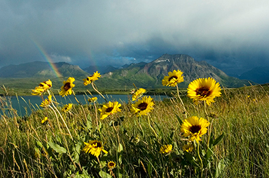
©Parks Canada Agency / Agence Parcs Canada |
Waterton Lakes National Park of Canada
Headquarters: Waterton Park, Alberta
International Peace Park; where the Rocky Mountains meet the prairie.
Rugged, windswept mountains rise abruptly out of gentle prairie
grassland in spectacular Waterton Lakes National Park. Here, several
different ecological regions meet and interact in a landscape shaped by
wind, fire, flooding, and abundant plants and wildlife. The park helps
protect the unique and unusually diverse physical, biological and
cultural resources found in the Crown of the Continent: one of the
narrowest places in the Rocky Mountains.
|
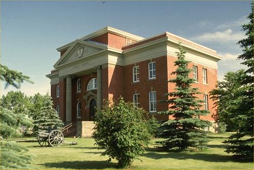
©Parks Canada Agency / Agence Parcs Canada, 1981 |
Wetaskiwin Court House National Historic Site of Canada
Wetaskiwin, Alberta
The Wetaskiwin Court House is a large red brick and sandstone building,
with projecting pedimented entrance. It is located east of Wetaskiwin's
downtown in a park setting on a 0.6 hectare (one-and-a-half acre)
site.
The Wetaskiwin Court House is significant for its historical association
with the development of judicial districts in Alberta. Alberta's rapid
growth, after becoming a province, led to the establishment of a
two-tier justice system with both central and district court functions.
Wetaskiwin was chosen as the seat of the judicial court district due to
the economic expansion it experienced as the junction point of the
Canadian Pacific Railway and the new railway north to Edmonton.
The Wetaskiwin Court House is important for its functional layout, as
expressed in the spatial organization of the building plan and form,
which provided for both administrative services and traditional court
functions to be combined in one building. The basement of the courthouse
was used for police services and holding cells, the main floor was
allocated for the sheriff and court administration, while a large
courtroom and ancillary spaces were located on the upper level.
Designed by A. M. Jeffers, shortly after his appointment as Provincial
Architect, the building is architecturally significant for its
restrained neo classical design elements and functional plan. Jeffers'
knowledge of courthouse design, from his architectural training and
previous experience in the United States, is particularly evident in the
building's spatial allocations. The courthouse, Jeffers' first, was the
second constructed after the province was created, and is characteristic
of courthouse design in the formative period of growth in western
Canada.
|
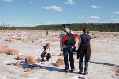
©Parks Canada Agency / Agence Parcs Canada |
Wood Buffalo National Park of Canada
Headquarters: Fort Smith, Northwest Territories and Fort Chipewyan, Alberta
UNESCO World Heritage Site larger than Switzerland.
As part of Canada's system of national parks and national historic
sites, Wood Buffalo National Park of Canada is our country's largest
national park and one of the largest in the world. It was established in
1922 to protect the last remaining herds of bison in northern Canada.
Today, it protects an outstanding and representative example of Canada's
Northern Boreal Plains.
|
©Parks Canada Agency / Agence Parcs Canada, Jack Porter, 2005 |
Yellowhead Pass National Historic Site of Canada
Jasper National Park of Canada, Alberta
Transportation route through Rocky Mountains
The Yellowhead Pass National Historic Site of Canada is a historic
travel corridor through the Rocky Mountains from Alberta to British
Columbia. The pass is located in Jasper National Park of Canada at its
eastern end and in Mount Robson Provincial Park at its western end. It
is one of the lowest elevation passes across the Great Divide in the
Northern Rockies.
This pass was used for centuries by First Nations peoples, from about
1825 to the 1850s by the Hudson's Bay Company principally to transport
leather from the Saskatchewan District to its posts in New Caledonia.
After 1906, it was used as a route for the Grand Trunk Pacific and the
Canadian Northern railways and in 1942, Japanese-Canadians who had been
interned during World War II began automotive roadway work on it. The
pass derives its name from Pierre Bostonais, called "Tete Jaune", an
Iroquois freeman active in the region in the early 19th century. The
heritage value of the site resides in its historic associations as
illustrated by the landscape and its associated historic
resources.
|
|