 |
|
Canadian Historic Sites: Occasional Papers in Archaeology and History No. 9
by Edward F. Bush The Gulf, Northumberland Strait and the Lower St. LawrenceAccess to the gulf is gained by the Strait of Belle Isle and the Cabot Strait to the north and south of Newfoundland respectively. The northern route, an ice-beset channel until well into mid-summer, offers the shorter passage to the British Isles from Quebec and Montreal. In the days of sail Belle Isle was avoided, but with the coming of the steamer by mid-century, the 15- to 20-mile-wide channel between the inhospitable Labrador and Newfoundland coasts attracted more shipping. The advent of the 17- to 18-knot subsidized mail steamer by the year 1905 accelerated this trend. A light did not mark this northerly passage until 1858, and as will be recalled from the previous chapter, only in 1839 had the mariner in the Cabot Strait the benefit of the two lights on St. Paul Island. Inasmuch as the bulk of the shipping used (and yet does) the southern route, it received the first attention. The increased steaming speeds in the latter half of the 19th century demanded a substantial improvement in navigational aids. The president of the veteran Allan Line, the principal steamship company in the Canadian service, put the issue bluntly to the Canadian government in 1869. Among the measures mandatory if Canadian aspirations for a fast mail service operating to the St. Lawrence were to be realized, the following lighthouse projects must have high priority:
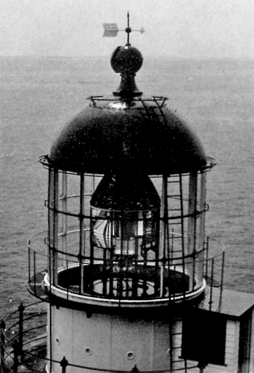
Construction at these sites was authorized by an order in council dated 14 January 1870.1 Short of such an outlay, aggregating $95,000, the chimerical "Canadian Fast Line" would never be feasible. Belle Isle Over a period of a half-century, three very important lighthouses were built at the Atlantic entrance to the Strait of Belle Isle on the long tapering island of rugged contour bearing the same name. Undertaken by the Canadian Board of Works, the first of these was constructed on a highly inaccessible site at the south end of Belle isle, 470 feet above the sea. An access road approximately a mile in length had first to be built from the beach to the site. At some points the gradient approached 40 degrees. The cliffs fell away precipitately to the shingle, and no cove or harbour lay within 20 miles. The extreme difficulty experienced in landing and hauling bulky and delicate apparatus under such conditions may be readily appreciated.2 The 62-foot stone tower was one of four undertaken simultaneously by the Canadian commissioners of Public Works. The stone was faced externally with firebrick of a light colour. The solidly built circular tower and lantern may still be seen at this lonely spot basically as it was in 1858, although no doubt the firebrick has been renewed and replaced several times. The first light was a fixed one fitted with dioptric apparatus of the 1st Order.3 In the photograph in Figure 38, the aerial for the radio installations, put up at a much later date, is visible on the left.
In 1880 this lighthouse was joined by a companion, to be known as the "lower light." As may be seen from Figure 39, the circular lantern was mounted directly on the stone foundation near the edge of a cliff 125 feet above the sea. The lower light was fitted with dioptric apparatus of the 2d Order, to serve in conjunction with the "upper light." A third lighthouse was built at the north end of Belle Isle in 1905. This 90-foot cylindrical iron tower was later reinforced with concrete and exterior supporting buttresses. The lantern was fitted with dioptric apparatus of the 2d Order, employing a kerosene pressure lamp with a 50-mm. mantle.4 This light went into service with the opening of navigation in 1905, in time for the new 17-knot Allan liners Virginian and Victorian, to be joined during the season of 1906 by the celebrated CPR liners, the Empress of Britain and her ill-fated sister, the Empress of Ireland. Until the construction of the Triple Island lighthouse on the Pacific coast, the lighthouse on the northern end of Belle Isle was the most northerly in Canada. All three Belle Isle lighthouses are basically in their original state today, although only the two at the south end of the island are old enough to be of historical interest. Point Amour A very fine and impressive lighthouse which was built in 1857 at the western entrance to the Strait of Belle Isle by the Canadian Board of Works is still in good condition today. Situated on the bleak Labrador shore, the Point Amour lighthouse, fully 109 feet in height, is a particularly handsome structure. The slightly tapered circular tower was built of stone, faced with firebrick and surmounted by a round lantern mounted on a circular, railed lantern deck or observation platform. Dioptric apparatus of the 2d Order signifies the importance of this light at the western entrance to the strait.5 The Point Amour lighthouse was the scene of a near disaster on the afternoon of 16 September 1889 when a British naval vessel, HMS Lily, went ashore in a dense fog. One officer and 30 of the crew made shore. The lightkeeper, Thomas Wyatt, was credited with saving four lives.6
Point Amour was one in a series of lighthouses built and maintained by the Canadian government on the Newfoundland and Labrador shore to serve ships on the St. Lawrence route. By the turn of the century Canada maintained a total of 10 light stations in Newfoundland and Labrador.7
With the exception of Cape Race, it will be noticed that all these lighthouses were in the Strait of Belle Isle or along the west or gulf coast of Newfoundland. Bird Rocks Construction of a lighthouse at the remote mid-gulf Bird Rocks location, hard on the main fairway of shipping inbound from the Cabot Strait, presented one of the most arduous projects attempted in Canadian waters. As the department's chief engineer, John Page, commented in his 1860 report,
A notation of the difficulties faced may be had from a glance at Figures 41 and 42. Captain Bayfield, Admiralty hydrographer, had aptly described these islets consisting of soft red sandstone or conglomerate in his survey of the gulf some 30 years previously. The islets presented near-perpendicular cliffs well over 100 feet in height on every hand. Access to the top could be gained in only one or two places, and that with no little difficulty; the device used by the construction engineers is shown in Figure 42. Bayfield concluded by stating that the landing of men and materials could only be effected in the calmest of seas.9 The largest of the islets, and presumably the one chosen for construction, was 1,800 feet in length by 300 in width, with sheer cliffs some 140 feet above the shingle. The site could be approached only during the settled mid-summer months of July and August.10 Carried out by contract let by the Department of Public Works, the 51-foot timber and frame tower "of a substantial description thoroughly bolted and fastened similar to the one recently erected on Machias Seal Island" was completed in 1870 and fitted with a powerful 2d Order lenticular light of French make.11
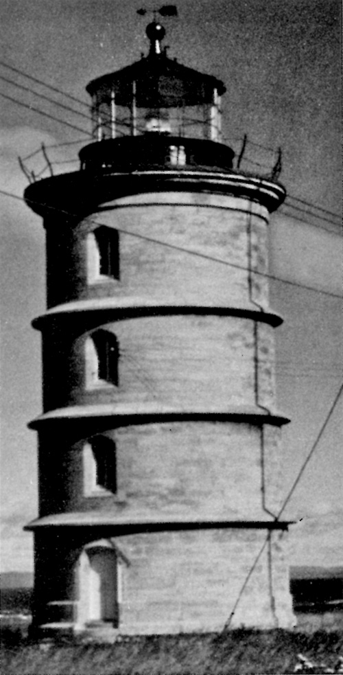
Pointe-des-Monts Based on the 1827 hydrographic survey conducted by Commander H. W. Bayfield, R.N., Anticosti Island, the head of the Gaspé peninsula and the broad reaches of the estuary became desirable sites for lighthouse construction.12 According to surveys carried out at the behest of the Lower Canada House of Assembly, a light at Pointe-des-Monts on the north shore would benefit vessels both in- and outbound, Anticosti Island, the scene of so many disasters, should have lighthouses established at both its eastern and western extremities. Cap-des-Rosiers, at the head of the Gaspé peninsula, would also be a desirable location, but Bayfield considered that this could be dispensed with if a lighthouse were built at the eastern end (Heath Point) of Anticosti. He offered the further opinion that the Green Island light would have been more effective on the neighbouring Red Islet, but that it was not worthwhile to move it. Bicquette Island was another favourable site, but because of its relative propinquity to Green Island, this project might be considered less urgent.13
The crying need for lighthouses on the St. Lawrence in 1828 was further emphasized by Captain Edward Boxer of HMS Hussar who had been engaged in survey work along its shores.
Admiral Sir Charles Ogle was yet more emphatic in his description of the hazards encountered along the coast for the want of lights.
In the main, Ogle's recommendations concurred with Bayfield's except that Bayfield preferred Cape Gaspé to Cap-des-Rosiers, and West Point of Anticosti Island to Southwest Point on the basis that the former would be visible from more points of the compass. But he feared that Lower Canada would lack the money for so extensive a program.16 It was true enough that lack of money had put off necessary lighthouse construction for a number of years, but in the 1828-29 session, the Lower Canada legislature appropriated the sum of £12,000 for this purpose. The total appropriation in 1831 reached £25,212 10s. 0d. local currency.17 The special committee on lighthouses appointed by the House of Assembly selected the east and west points of Anticosti Island and Pointe-des-Monts as sites; they further resolved to contribute toward the building of lighthouses on St. Paul Island and Cape Ray, two points vital to the navigation of the Cabot Strait giving access to the gulf. These projects had to wait the concurrence of the maritime colonies.18 The Pointe-des-Monts site had already been selected by the Quebec Trinity House in 1826 as a good location to serve as a point of departure for outbound vessels in order that they keep well clear of Anticosti Island and as a checkpoint for inbound shipping. The Trinity House board concluded its recommendations to the governor that the utility of a light at Pointe-des-Monts was supported by "all Masters of Vessels trading to this Country."19 The original Pointe-des-Monts lighthouse, a 90-foot circular stone tower, has been replaced in recent years with a skeleton steel tower of contemporary design, though the stone tower is still standing and reported in good shape. The first lighthouse. completed in 1830, had walls six feet thick at the base, tapering to two feet at the lantern deck.20 The polygonal copper lantern was of the same dimensions as that installed at Green Island, measuring 10 feet 6 inches in diameter and 6 feet in height. It was fitted with glazing of "polished Plate Glass of double substance as made for the use of lighthouses."21 The catoptric light consisted of 13 Argand burners of brass fitted with copper tubes and "thirteen improved strong Silver plated, high polished parabola reflectors on improved principles," the estimate for the whole lantern assembly coming to £960.22 Unfortunately, as is so often the case, this estimate was very much on the low side, the final bill being £1,766 3s. 6d.23 This handsome structure (see Fig. 44) stood sentinel at this point for more than a century. The original optic was replaced with a more effective lenticular apparatus sometime in the eighties or nineties or after the turn of the century. Anticosti Island The next lighthouse to be built in this region was that on Southwest Point of Anticosti Island, guarding the approaches of the broad estuary from the gulf. Originally Captain Bayfield had favoured West Point, but on consideration, Southwest Point offered the twin advantages of closer proximity to the shipping lanes and suitable building materials (limestone and sand) were available on the site.24 The 75-foot lighthouse of stone construction went into service in 1831, the first on Canadian shores to display a revolving light. The annual upkeep of this lighthouse was estimated at £525, a figure which included the cost of 600 gallons of sperm oil for the light at the rate of 10 shillings per gallon. The keeper was paid £130 per annum. The tower, 36 feet in diameter at the base, was completed by the contractor for the sum of £3,350 local currency and the lantern with the optic was supplied for £2,800. The revolving light swept the horizon from a height of 100 feet above high water with a range of 15 miles.25 A second lighthouse at the eastern extremity of Anticosti Island was established in 1835, and a third on English Head in 1858 at the western extremity. This 109-foot circular stone tower on West Point was constructed under the aegis of the Canadian Department of Public Works. Completed in 1858, the West Point lighthouse was of similar dimensions, design and apparatus to the Point Amour installation, but unlike the latter, the West Point structure was replaced in 1967. None of this trio has survived to the present; indeed of all those cited so far, only the Green Island and Pointe-des-Monts lighthouses are extant today.
Point Escuminac in 1841, the New Brunswick lighthouse commissioners established an important coastal light at Point Escuminac at the northern entrance to the Northumberland Strait. A quarter-century later a twin sentinel joined it on the North Point of Prince Edward Island, on the opposite shore. Described as an octagonal wooden building 58 feet in height, the focal plane of its fixed light shone 78 feet above the sea and was visible 14 miles in clear weather.26 A measure of the importance of the Point Escuminac light to ships entering or leaving the Northumberland Strait was its subsequent equipment with a lenticular light of the 3rd Order. The old lighthouse was replaced with a steel tower installation in 1963. Miscou Island Another fine old lighthouse, largely built of hand-hewn timbers, 80 feet in height and eight-sided, was constructed under the authority of the Quebec Trinity House on Miscou Island in 1856. This one has survived to the present and is said to be in good condition. Eventually it, too, was fitted with a powerful dioptric light of the 3rd Order, and early this century, with a diaphone fog alarm. Situated off Birch Point, the Miscou Island light is a major coastal aid standing at the southern entrance to Chaleur Bay.27 Point Prim The oldest lighthouse to grace the verdant shores of Prince Edward Island, Point Prim, built in 1846 and still in service today, stands sentinel at the southern end of Hillsborough Bay on the outer approaches to Charlottetown Harbour. The 60-foot circular brick tower topped by a polygonal lantern is still in its original condition, complete with a central weight shaft dating from the days of mechanically actuated rotary mechanisms. This feature is simply a relic of the past, for the light source and rotary machinery has long since been electrified. The Point Prim lighthouse is now fully automated, in common with an ever increasing number of lights. The lantern platform is gained by four flights of stairs. Apart from the mercury vapour electric light source and the lantern platform railing, the Point Prim light and optic are the original installation. It is quite a handsome structure on a commanding site, and one of the showplaces of the island.
Cap-des-Rosiers The Cap-des-Rosiers lighthouse, completed in 1858 on Gaspé Cape, is the fourth in the handsome series of Public Works lighthouses and today is considered the showpiece of the Quebec agency. One hundred twelve feet in height, its circular lantern housed a 1st Order dioptric light, indicative that the Cap-des-Rosiers installation was considered a major coastal light. Fortunately the journals of the Canadian legislature record considerable detail on this lighthouse, which is shortly to be removed from service. The foundation, set 50 feet back from the cliff edge, extended 8 feet below the surface. The masonry walls of the 112-foot tower tapered from a thickness of 7 feet 3 inches at the base to an even 3 feet at the top; similarly, the base diameter narrowed from 25-1/2 feet at ground level to only 17 feet at the lantern platform. The tower contained nine storeys including a basement and the light room directly below the lantern. Windows were set at each storey or landing in an alternate pattern.28
The windows were to be arched with stone, and the door with stone on the inside and brick on the exterior. There were to be two doors to the tower, the outer of which was to be 7 feet by 3 feet.30 The exterior was to receive three coats of white lead and oil paint; the interior surface of the walls was to be finished with two coats of plaster. It is not surprising that so carefully and soundly built a structure should have lasted over a century and still be reported in excellent condition. In the near future the Cap-des-Rosiers lighthouse may be offered to the crown for possible preservation, since a light is no longer needed at this point. It is a handsome and impressive structure, somewhat similar in form and design to the series built on Lake Huron and Georgian Bay at the same time. Cap-des-Rosiers is readily accessible by motor, in contrast to Belle Isle or Point Amour, for which the services of a helicopter or supply vessel would be required.
Father Point Transatlantic travellers of a few years ago, when the steamship lines retained more custom, will remember Father Point some 180 miles below Quebec where the pilot was dropped on the outbound voyage. The first lighthouse at Father Point, according to the light lists, was put in service in 1859, although one rather obscure source under the signature of a Raoul Lachance speaks as early as 1800 of a lantern on the roof of a house 45 feet in height, the light consisting of five oil lamps fitted with 21-inch reflectors.31 The first lighthouse cited in the light lists (Admiralty 1864) is described simply as octagonal with the focal plane of the light 43 feet above high water. This lighthouse was destroyed by fire on 13 April 1867; plans were at once set afoot for its replacement at an estimated cost of $1,600 to $2,000.32 This lighthouse in turn was replaced with a 97-foot, eight-sided reinforced concrete tower in 1909 in order that a more powerful light and hence larger lantern might be installed. The Father Point lighthouse was fitted with external buttresses in similar manner to that at the north end of Belle Isle. As a major coastal light Father Point rated dioptric apparatus of the 3rd Order, manufactured by the Parisian firm of Barbier and Turenne. It is understood that this optic with a mercury vapour light is still in service at Father Point. Green Island The first lighthouse built on the shores of the St. Lawrence and still standing today was that on Green Island in 1809. This is the third oldest lighthouse in Canada, being pre-dated only by the Sambro light off Halifax, and Gibraltar Point, no longer in use, on Toronto Island. As early as 1787 one Peter Fraser, who had been working 15 years for the improvement of St. Lawrence navigation, went to London to raise funds among city merchants trading to Canada. Fraser estimated that fully 8,000 tons of shipping passed Green Island off the mouth of the Saguenay River in the course of a year. A light duty of 9d. per ton would finance the Green Island project.33 Fraser's recommendation was supported by Commodore Sawyer, R.N., in a report written aboard the Leander in the harbour of Quebec, 9 October 1787.
But it was not until the spring of 1806, more than 18 years later, that the executive council of Lower Canada took the matter in hand. By late November of that same year, the masonry work on the 56-foot circular stone tower was finished. A further sum of £875 local currency was needed in addition to the original £500 grant to complete the project. The lantern was supplied by George Robinson of London, and the lamps and reflectors by the London firm of Brickwood and Daniel at a cost of £388 sterling. The stone tower was topped by a double flooring of three-inch oak plank sheathed with copper, on which was mounted the lantern.35 An early inspection by the deputy master of the Quebec Trinity House on the night of 13 September 1810 found all in good order.
The first keeper of the Green Island lighthouse was Charles Hambledon, who was instructed to be in continuous attendance from 15 April to 15 December. His duties included the care of the lamps, reflectors and the lantern glazing, for which he was paid £100 per annum. The keeper must be "careful, sober and intelligent."37 He was required to keep a daily journal, "of all occurrences and observations" to be forwarded to Quebec once a quarter.38 Late in 1811, the following supplies were ordered for the Green Island lighthouse:
The Green Island structure remained the sole light on the shores of the mighty river for a full 21 years. Stone Pillar and Red Islet The 1840s saw the establishment of three lighthouses below Quebec. Two of these, Stone Pillar and Red Islet, were of similar design—circular, grey stone towers, each 52 feet high with circular lanterns. A distinctive feature of these two towers was the three string courses spaced at equidistant intervals, mainly a decorative embellishment. The Stone Pillar lighthouse was built in 1843, and the Red Islet structure in 1848. According to local authority, stone for the latter was brought out from Scotland. Both lighthouses are standing today.40 As recently as 1966 the Red Islet light was described as catoptric long focus. of which there must be very few left in service.
Bicquette Island The third of this trio and farthest downstream of the three was Bicquette Island, built in 1843 by the Quebec Trinity House in the broadening reaches of the river below Quebec. Shipowners and mariners had been petitioning for a light at this point as early as 1828.
Sir John Barrow, secretary to the commissioners of the Admiralty, recommended in 1838 the installation of a strong light on Bicquette Island, but with a characteristic to distinguish it from the fixed light on Green Island.42 The Quebec Trinity House, on the other hand, expressed a preference for closely adjacent Bic Island on the grounds that fuel and fresh water were more readily available; but in the sequel, Bicquette Island was the chosen site. Construction estimates stood at a minimum £6,000.43 The circular stone tower 74 feet in height was completed with a revolving light in 1844. The first fog alarm was a gun, to be fired hourly in thick weather. The Bicquette lighthouse is another survivor from the colonial past. It is understood that the fog signal gun is still on the site, though replaced by more effective devices many years ago. This construction in the 1840s notwithstanding, at mid-century the words of Beaufort's report to the Admiralty prepared in 1834 were still basically true,
These were to be forthcoming in the next few decades. |
|||||||||||||||||||||||||||||||||||||||||||||||||||||||||||||||||||||||||||||||||||||||


|
||||||||