 |
|
Canadian Historic Sites: Occasional Papers in Archaeology and History No. 19
by Gordon Bennett Between the WarsI "A gold rush is like a war," George Black once explained. "You feel it in your blood. It is exciting — intoxicating. It reveals, as in a flash, the monotony of ordered days and ordered ways."1 By 1914 the prospect of another Yukon gold rush was little more than an empty dream. Most of the Klondike had come under the umbrella of consolidation and what remained would have been hard put to bestir the enthusiasm of the most optimistic prospector. The "intoxicating" days of 1897-1900 were gone forever, replaced by the daily routine of working for one of the large mining companies. If another gold rush was merely the product of an imaginative mind nourished by the interminable Yukon winter, war was not. When hostilities broke out in Europe in August of 1914 a certain exhilaration swept the Yukon. Black's description of the stampede spirit worked both ways and war, though certainly less preferable than a gold rush, nevertheless furnished excitement and relief from the "monotony of ordered days and ordered ways" that had become the measure of life in the territory. But the excitement was purchased at tremendous cost. While the rest of the nation shared, albeit with some disparity, the benefits accruing from wartime mobilization,2 these benefits, with the notable exception of the Whitehorse copper industry, completely by-passed the Yukon. The impact of the war on gold mining — the backbone of the territorial economy — was particularly severe. From 1908 through 1914 the industry had exhibited positive signs of recovery after seven years of decreasing annual production.3 Under the influence of wartime conditions, however, the industry found itself caught in a vice of rising production costs and rigid gold prices. Writing in 1918, the territorial gold commissioner observed that "each successive year since 1914 has seen a tremendous increase in the price of all kinds of provisions and particularly in dredge machinery and repair parts, and there has been no increase in the value of gold mined."4 The price-cost squeeze was further exacerbated by the withdrawal for war service of a large number of skilled miners and supervisory personnel, a factor that adversely affected the operational efficiency of the industry.5 Given the region's remoteness and the inflationary pressures unloosed by the war, it was impossible to replenish such a drain on the labour pool from outside sources. Within the territory itself, the war produced spectacular increases in the cost of living. Operating on the barest of margins, the gold companies were forced to deny labour a corresponding measure of wage relief. In 1917 the Yukon Gold Company, the only mining concern in the Klondike extracting enough gold to qualify as a genuine producer, rejected the moderate demands of its employees for a "10 per cent increase [in] wages to meet [the] 60 and 100 per cent rise on foodstuffs." The company's intransigence was followed by an act of last resort in an industry wholly dependent on seasonal operation: a strike.6 No less serious than the war and of greater long-term consequence were the managerial decisions taken within the gold mining industry itself. During the period 1908-35 extractive operations were undertaken on less than half the known gold-bearing fields in the Klondike. This failure to exploit to the full the resources of the district cannot be attributed to a deliberate policy of building up reserves and following a programme of systematic extraction, a policy that would have been economically sound. Rather it must be explained in terms of a single individual's attempt to gain hegemony over the entire gold fields, an attempt that was characterized by an almost total disregard for the welfare of the Yukon. It is ironical that this individual, A.N.C. Treadgold, was the architect of consolidation. For it was Treadgold, with his intimate knowledge of frozen gravels and the most efficient means for working them, who had been largely responsible for the conversion to capital-intensive mining. But Treadgold was obsessed by an even greater dream than overseeing the revolution in mining technique which he had initiated; he dreamed of bringing the entire Klondike under his personal control. Treadgold pursued his goal through the simple expedient of using the assets of the companies with which he was associated to purchase additional claims. Had he financed these purchases out of the profits realized from his mining operations, he might well have achieved his aim and maintained at the same time a satisfactory level of production, but Treadgold employed investment capital which should have been used to underwrite extraction. Francis Cunynghame, Treadgold's biographer, has written that under Treadgold's stewardship, the Granville Mining Company was "a mining company which could not produce gold and had no means to do so."7 The same can be said of all the companies with which Treadgold was later connected. Percy Reid, territorial gold commissioner during the mid-1920s, expressed his exasperation with Treadgold by dismissing him as little more than a speculator: "Mr. Treadgold is not an operator, but is merely a promoter."8 As unfair to Treadgold as Reid's assessment was, the gold commissioner accurately captured Treadgold's fatal weakness that was to deprive the mining industry of the liquid capital required to maintain its productive capacity. The outcome of Treadgold's dream to control the Klondike was to leave gold mining proper in a relative state of suspended animation between 1918 and 1932 and bring about his ultimate downfall.9 The impact of the war and Treadgold's struggle can be seen in the annual figures for gold production published by the Dominion Bureau of Statistics. Between 1915 and 1930 there was a protracted falling off in production from a high of $5,125,324 in 1914 to $734,202 in 1930. Between 1924 and 1932 total annual production did not exceed one million dollars, hitting a low of $529,220 in 1926. In 1923 silver-lead production in the Mayo district superseded the Klondike as the principal mineral-producing region in the Yukon.10 On a more tangible plane, the decline in gold production found a mirror image in the community of Dawson. Where once the mud flat at the confluence of the Klondike and Yukon rivers had played host to an estimated thirty thousand people, 975 were all that could be mustered for the 1921 census.11 While falling production and a decreasing population were not novel phenomena, Dawsonites reacted to them in a manner that was far different after 1918 than had been the case prior to the war. Before the war there had been a pronounced tendency to regard post-gold-rush Dawson as a settled, progressive community that had evolved out of the raw mining camp synonymous with the stampede. But the war, the economic havoc created by Treadgold's ambition to control the Klondike, and the sinking of the SS Princess Sophia in October of 1918 destroyed this complacent perspective.12 When Laura Berton returned to Dawson in 1920, Dawson was not the confident little enclave she had left four years before, but a "decaying town" sapped of its energy and spirit. The unmistakable signs of a ghost town in the making were manifest. Physically, the settlement possessed enough buildings to accommodate ten times its population. The population itself, already ravaged by war, a waning economy and the Sophia disaster, was getting progressively older. A generation separated the Dawson of 1897-1900 from the Dawson of 1920. In the interim, immigration had been negligible. Dawson's single hospital was full "not of patients," Mrs. Berton wrote, "but of old men." Funerals became social events. Where a quarter of a century before, Dawson had revolved around the gambling tables and the dance halls, "it was the funerals around which the town revolved" during the twenties.13 By 1920 the Dawson Daily News, the only local newspaper to survive the century's first decade, had ceased daily publication. Four years before, the News had carried an obituary to an era of social history with a banner headline that proclaimed "Last Day of the Saloon in Yukon." In 1918 the Side Streams Navigation Company of Dawson terminated its operations, while in the same year the United States government withdrew its consular representative from the city. At the end of the war the total annual tonnage arriving at Dawson had declined to less than ten thousand tons and in the words of G.B. Edwards, general agent for the British Yukon Navigation Company, "waterfront privileges are fast depreciating." By 1920 the only living reminder of Dawson's golden age as an entertainment centre was a single theatre, but one would have been hard pressed to find any resemblance between the productions and the performers of 1899 and 1920.14 If one word best described the Dawson of 1920, that word was "shrinkage." One could see it everywhere — in the population figures, in the economy and in the spirit of those who remained. Even the city itself was shrinking. Community services were too expensive to provide over a widely scattered area and as a consequence there was a steady concentration of people toward the core. But Dawson had a history of escaping the ghost town fate so often predicted for it after 1900. In this there was an unfailing and perhaps to some a perplexing consistency. The twenties were difficult years for Dawson, but the town survived them and when the Yukon Consolidated Gold Corporation commenced full-scale production after 1933, Dawson was ready once more to preside as the Yukon's major city.15 The Klondike's postwar economic slide was in large measure offset by developments that occurred in the Mayo district during the late teens and early twenties. The discovery of a rich silver-lead outcropping by Louis Bouvette on Keno Hill in 191916 climaxed a 13-year search for an extensive lode deposit in the area17 and attracted two large companies, Keno Hill, a subsidiary of the Yukon Gold Company, and the Treadwell Yukon Company of San Francisco, with sufficient capital to organize the industry on an efficient basis. With the withdrawal of Keno Hill in 1924, the way was cleared for Treadwell Yukon to establish virtual control over the entire district. This it did with the result that by 1926 the Mayo district and silver-lead surpassed the Klondike district and gold as the primary producer and product in the Yukon.18 This radical change in the territory's economic centre of gravity had a profound impact on the transportation system. At the very time that it was becoming increasingly apparent that the territorial economy could no longer sustain the existing transportation system, a new challenge issued from the Mayo district.19 This challenge was substantially different from the challenge that had been posed in the Klondike. It demanded a response to the transportation problem that was in keeping with the peculiar needs of lode mining as distinct from placer mining. In the past the transportation system had proved singularly incapable of coming to grips with a problem of this nature,20 but the mineral deposits of the Mayo district enjoyed two palpable advantages over those of other areas where lode mining had previously been attempted; a rich assay and extensive occurrence. As a consequence, transportation was able to fulfill its proper function; to assist a viable mining industry in moving the products of the mine to outside buyers and to deliver the manpower and material needs of the industry to the site of its operations. This constituted a major shift in the burden previously borne by transportation vis-à-vis the lode-mining industry. In the case of Whitehorse copper, for example, transportation had been charged with the impossible task of sustaining an industry that was initially tenuous owing to the low-grade nature of its product. II That aspect of transportation most sensitive to the economic changes of the 1920s was the road system. As we have seen, overland transportation of the non-rail variety had assumed an ever-increasing importance in the years immediately preceding the war, both as a necessary adjunct to the seasonal service furnished by water and as a vital tool in the movement of supplies and services between settlements which were not situated on existing river routes. This was particularly true of the Mayo district where mining properties tended to be scattered over an area that was 40 miles from the nearest steamboat landing, the town of Mayo, and the most accessible waterway, the Stewart River. Given the resource base of the Mayo economy, transportation of a cheap and efficient variety was crucial. As J.S. McNeill, the territorial superintendent of roads explained, success in lode mining depends in great measure on low freight rates, the grade of ore which can be profitably mined depending largely on this item. Supplies and equipment are needed in large quantities, and the product mined for shipment is of a nature that involves considerable tonnage.21 Unfortunately, events were taking place in Ottawa that would undercut the realization of an efficient road system. Prodded on by the opposition which claimed that the federal grant in support of the Yukon was excessive, the government began a hard examination of its annual Yukon appropriation. In one exchange recorded by Hansard in 1917, an opposition MP stated that "little short of $1,000,000 was being paid by Canada for the 9,000 people or thereabouts in the Yukon." "This is a huge figure," he argued. In going through the various items last year, I did not find the slightest regard was paid to the changed conditions [declining production and population].... It simply amounted to this, that it cost about $100 per head to keep those 9,000 people in the Yukon. When the proposition is put that way it does not look very economical.22 In psychological and economic terms, the introduction of federal retrenchment measures after the war could not have occurred at a more inopportune time. The territorial economy was at a critical juncture. The silver-lead industry had yet to progress beyond the developmental stage and a sizeable investment was required to encourage further development. Geographic decentralization of the resource base, the bugbear of any remote region dependent on primary industry, made difficult, if not impossible, the implementation of policies designed to operate on the "economies of scale" principle and created conditions whereby a costly duplication of services could not be avoided. Paradoxically, reductions in government spending coincided with an upswing in the economic outlook of the territory. In the Yukon there was a general feeling that for the first time in 20 years the future was bright. Departmental estimates for the 1921 fiscal year, however, offered clear proof that the government did not share this confident appraisal of the territory's future. Expenditures were cut by 35 per cent over the previous year, an action that was regarded in the Yukon as evidence that the government was "very ignorant of or absolutely indifferent to the real situation here." Compared with the appropriation expended in 1914, the estimates for 1921 represented a reduction in government spending of 64 per cent.23 Territorial reaction to the course adopted by Ottawa was bitter. In a hastily despatched night letter to the then prime minister, Arthur Meighen, the Yukon Development League "respectfully" reminded him that the Yukon gave more men and money per capita to the Dominion for war purposes than any other section of Canada without receiving [a] cent [of] war business. Our only industry [gold mining] was severely handicapped during [the] war... but we carried on and produced gold for the Dominion... and why the government should now try to put Yukon almost entirely off the map of Canada, the loyal and patriotic subjects here cannot understand. The league asserted that few facets of territorial life would escape the adverse effects of the government's fiscal policies. Schools, hospitals and libraries would be forced to close for want of support while assistance for the indigent would have to be eliminated. That facet most seriously affected from the viewpoint of the territorial authorities, however, was the overland transportation system, for federal retrenchment was effected in large measure at the expense of road construction.24 Despite the territory's indignation and the growing evidence of the importance of the Mayo strike, the dominion government refused to modify its position. Considering the thrust of federal economic policies during the 1920s, this is hardly surprising. While the minister of the Interior conceded that there existed "a persistent demand for road construction to enable people engaged in mining to get out the products of the mine," very little in the way of an increased appropriation was forthcoming.25 An alternative source of money to finance construction was derived from government-run liquor store revenues.26 Another was the Mayo mining companies, especially Treadwell Yukon. This last was particularly significant as it gave Treadwell Yukon an important voice in determining the location and nature of roads in which it had an interest. It also brought to an end an era in which the government had assumed exclusive responsibility for building and maintaining Yukon roads.27 During the 1920s the policy of the territorial administration was "to maintain the main or trunk roads in as good a condition as finances [would] permit; and, where possible, to assist in constructing trails from these main roads to districts which show reasonable promise of development." In determining the location for a road in the Mayo district, the superintendent of Public Works, J.S. McNeill, would appraise the wishes of the transportation company serving the route. While this type of consultation was generally fruitful, it was not always successful. As McNeill candidly admitted, most of the teamsters "had their own ideas on what would be the best route" and in one case a road was built which did not prove satisfactory to the ore-hauling contractor and alterations were necessary. In the Klondike, where a different set of economic conditions prevailed, road requirements remained relatively static throughout the 1920s, There, government policy was primarily confined to maintaining existing roads rather than undertaking new construction. Before the commencement of each new mining season, the territorial public works department would canvass the mining community for a list of creeks on which operations were planned for the coming year in order to avoid maintaining those roads which would not be used.28 Two aspects of road building that had not seriously interfered with road construction in the Klondike, permafrost and the time lapse between starting and completing a road, proved to be serious impediments to traffic movement in the Mayo district. While roads had been built in sections and brought up to standard over a period of years in the area tributary to Dawson, increased road use in the Mayo district, both in terms of frequency and tonnage, required more rapid completion and a higher standard of construction. In 1922 the Mayo Board of Trade telegraphed the minister of the Interior to "strongly urge" the passage of a sufficient appropriation to complete the trunk road between Mayo and the town of Keno, the centre of the silver-lead mining industry, "this season instead of spreading it over [a] number of years." The government's response was that "a reasonable amount of money" should be put aside for roads in the Mayo district. Lack of funds was one of the chief obstacles to road building. As McNeill observed, "It cannot be expected that we can make a good road from one year's appropriations, but whatever amount of work that is done will represent progress along permanent lines."29
In the early years road builders had circumvented the problem of permafrost by not disturbing permanently frozen ground and by ensuring that enough insulation covered the ground to prevent melting. This was an adequate solution so long as roads were essentially temporary and not subject to heavy use. Such was not the case in the Mayo district, however, and as a result, an improved technique for dealing with permafrost was developed. The ground was allowed to thaw, the thawed portion being then removed. Approximately three years were required to establish the desired depth and width of the road. The same procedure was followed in roadbed preparation, the object being a stable foundation for the road surface. Temporary changes in soil consistency during the thawing period made drainage a constant problem throughout the construction phase and required much ditching.30 The introduction of motorized vehicles in the early twenties was another factor tending toward improved roads. After 1912 an extensive network of roads had been built by the territorial government to connect the placer camps in the then Duncan district with the head of navigation at Mayo.31 These roads were designed "to a standard that would allow of wagons being used during dry weather with moderate loads."32 While adequate to the demands of placer mining, these roads were not able to satisfy the transportation needs of the silver-lead industry. In 1915 the cost of freighting one ton of ore overland from the mines to the town of Mayo was $20, compared to a figure of $22 for transhipment from Mayo to San Francisco. Overland shipments, moreover, were limited to the winter period exclusively in order to take advantage of the superior road surface furnished by snow.33 That this shipment and others like it returned a profit in spite of the high cost of transportation was due to two factors — the existence of extremely rich ore and the method of hand sorting. Selected ore samples from Galena Creek taken during the 1915 season, for example, were assayed at $153.00 to $266.72 a ton and while ore of comparable value occurred only irregularly, many deposits showed commercial promise.34 Hand sorting, or "hand-cobbing" as it was also called, was a simple variation of the high-grading technique used by gold miners during the rush and entailed manual separation of high-quality ore from that of low value for shipment to the smelter. Nevertheless, establishing the industry on a firm foundation demanded more than simply relying on rich ore occurrences and the costly, time-consuming method of hand sorting. What was needed was a breakthrough in the transportation impasse between the towns of Keno and Mayo Landing. It is not surprising that the first attempt to resolve this difficulty involved a railroad. In January 1921 a company was organized to build a railway from the junction of the Mayo and Stewart rivers to the McQuesten, by way of Mayo River, Duncan Creek and Crystal Valley. This scheme wrought a counter proposal from interests representing the defunct Klondike Mines Railway to extend their line from Dawson to the silver camp or, alternatively, to construct a railway from Mayo Landing to the mines. Although a federal charter was secured by the former in March of 1921, construction was never begun and, despite its intimations to the contrary, the Klondike Mines Railway Company showed no further inclination to take on the project.35 In light of the failure to construct a railroad and in the absence of sufficient government assistance for road building, the Mayo district operators were forced to confront the transportation problem on their own. In 1922 Treadwell Yukon pressed a ten-ton Holt tractor into service. The experiment was a marvellous success, the tractor moving forty-five hundred tons of ore that season from the mine to Mayo Landing. The introduction of tracked vehicles reduced transportation costs by 75 per cent and in the words of one contemporary, "revolutionized winter transportation in this country." Thereafter the company shipped by tractor exclusively.36 The revolution in overland transportation presaged by the use of tracked vehicles constituted an advance of giant proportions when it is considered that in the same year another miner, Robert Fisher, hauled three tons of ore from his claim to Keno City by dog team, a distance of 17 miles. Treadwell Yukon added another caterpillar to its fleet in 1923; trucks were coming into common use and the superintendent of roads was predicting that once "objectionable grades" on the Mayo-Keno road had been removed, shipments of 70 to 75 tons could be handled on a regular basis.37 During the 1923 season the territorial government concentrated its road-building efforts on the 37-mile trunk road between Mayo Landing and Keno City. Modern construction equipment was purchased and put to use with "encouraging results." Treadwell Yukon and Keno Hill, the two companies which stood to gain most from its completion, contributed to the construction of the road. While not conforming to a uniform standard in its entirety, the road was a major factor in reducing transportation costs. Rates on freight delivered to Keno City from Mayo were cut from 15 cents a pound in 1920 to 5 cents a pound in 1923 exclusive of freight hauled by track-vehicles which was cheaper still. Completion of the road also led to a substantial increase in traffic movement during the summer months. In 1927 Atyey tractor trailers superseded wheeled carriers for summer use with a consequent increase in carrying capacity and less road damage. By 1928 Mayo-Keno freight rates had levelled off at one to one and one-half cents a pound depending on quantity.38
If the introduction of caterpillers "revolutionized" winter transport, the installation of a concentrating mill by Treadwell Yukon in 1924 was tantamount to ushering in the millenium.39 Essentially, concentration accomplished the same object as hand sorting but far more efficiently. It involved crushing the ore, then subjecting it to processes of clarification and flotation whereby the unit weight of the end product, or concentrate, was greatly increased in value. Some idea of the significant savings resulting from concentration is given by data which show that the Treadwell mill reduced ore to concentrate in the ratio of 10:1 to 15:1.40 Simply stated, this meant that ore slated for shipment had increased in value ten-fold while transportation costs had remained constant; or conversely, that transportation costs had been reduced 90 per cent. Concentration solved another transportation problem, at least for the smaller operators. It enabled them to sell their ore to Treadwell Yukon for treatment and receive immediate payment, instead of waiting for the smelter returns. In an industry where it was impossible to extract, treat, transport, smelt and get paid in a single season and where the market price of silver-lead could widely fluctuate from year to year, this was a positive boon.41 Installation of the concentrator marked a radical departure from previous attempts to deal with the transportation problem. It demonstrated that possible solutions to the problem were not confined to the conventional answers of the past; refining existing modes of transportation, developing new ones and improving access routes. It portended an increasingly sophisticated approach which saw transportation in terms of the economic viability of the territory and fostered a realization that whatever facilitated the movement of people, supplies and services, whether it be the designation of a new port of entry, a telegraph or wireless or even the selection of a new capital, entailed a legitimate response to the transportation problem.42 In 1930 Treadwell Yukon expressed dissatisfaction with the arrangement whereby it had shared a portion of Mayo road construction and maintenance costs with the government. The change was precipitated by the government's refusal to assist in clearing snow from one of the company's roads after a particularly heavy storm, and a rumour to the effect that roads used by tractors would no longer be maintained. The government's decision in this regard was particularly surprising in view of the fact that Treadwell tractors had carried mail between Mayo and Keno that same winter without charge when snow had prevented the regular contractor from operating his trucks. Additionally, the company had improved certain sections of the Mayo-Keno trunk road on its own initiative and at its own expense. Company roads, moreover, assisted neighbouring operators and increased the value of adjacent properties. Livingston Wernecke, the company's general manager, argued that the "building of all roads," including Treadwell Yukon's, was "a true and proper function of the Government, either Federal or Territorial" and added that by not doing so, the government was "side-stepping one of its functions; a function that is extremely important to a new country."43 In response to Wernecke's charge, the government conceded that it was "very difficult to take exception to the contention that the matter of building roads is one for the Government"; nevertheless, it held that deferment of the royalty tax on mineral production, which had not been imposed until 1929, demonstrated that "the Government has in every other possible way given assistance to the mining industry in the Mayo district."44 There the matter died, though not to the satisfaction of Treadwell Yukon. The controversy itself is nonetheless important. It shows that the debate over the role of the government in northern development is not a product of the 1950s as has generally been assumed and it offers clear proof that roads are not a newly discovered palliative for the problems of resource exploitation in the North. By 1920 the condition of the Overland Trail had, in Mrs. Berton's words, "greatly depleted." "There were fewer travelers to the mining camps now," she wrote, "for the palmy days were over." Many of the roadhouses which in the old days had been spotted every twenty-two miles along the winter road were closed. Passengers now had to provide their own lunches and these were eaten in the open after being thawed out by a bon-fire on the side of the trail. In the old days we had made the journey in less than a week. Now the stage only made a post a day and, if the trail was bad, the trip often took longer than a fortnight.45 In 1921 the White Pass and Yukon Route surrendered the winter mail contract it had held for 20 years and terminated its Overland Trail operations. The company had initiated winter hauling in the first place to secure the mail contract for its sternwheelers. With the failure of the Side Streams Navigation Company in 1918, the last obstacle to complete monopoly on the Yukon waterways was removed and with it any competition for the postal contract. The winter contract was taken over by Coates and Kastner in 1921-22 and later surrendered to Greenfield and Pickering, who were superseded in turn by Richards and Phelps during the late twenties.46
In the years preceding the successful establishment of the silver-lead industry, Dawson had been the main supply centre and distributing point for the Mayo camp. In 1913-14 a 40-mile wagon road was built from the mouth of Hunker Creek to Flat Creek, from which a good winter road was built to Mayo Landing.47 In the meantime, the Overland Trail was rerouted through Black Hills and Scroggie to serve the placer communities that had sprung up there.48 The advent of large-scale silver-lead production, however, underlined certain deficiencies in the existing overland transportation system. Consequently, the Overland Trail was again rerouted to provide direct communication between Whitehorse and Mayo. The Whitehorse-Minto section was left intact, but at Minto the route was diverted northeast to Willow Creek where it crossed the Pelly River some 30 miles above the site of the old river crossing. From Willow Creek the trail was extended to Crooked Creek which became the terminus of the main road. From there the trail branched off to Mayo on the east and Dawson on the west.49 Dawson's diminishing status as a metropolitan centre with an attendant hinterland can clearly be seen in the diversion of the Overland Trail, but Dawson's decline was not limited to the loss of its metropolitan function. Throughout the 1920s the Dawson area steadily lost ground as the territory's main economic region and in 1926 it was superseded by the Mayo district. This decline was reflected in the flow of traffic over the Overland Trail which by 1928 was moving in much greater quantity over the Mayo division of the Overland Trail than its Klondike counterpart.50 Route modifications were accompanied by technological changes in the modes of transportation. In 1923-24 trucks replaced wheeled stages for spring and fall travel while horse-drawn sleighs gave way to caterpillars for winter use. These improvements were initially confined to the Whitehorse-Yukon Crossing section of the Overland Trail, beyond which the old modes of transportation were retained. According to Mrs. Black, caterpillar operators were limited to two-hour shifts as "the fearful lurching of the 'cat' over the rough trail rendered it unbearable for a driver to work" for an extended period of time. Occasionally Treadwell Yukon assisted the regular transportation company by freighting supplies with its own tractors between Whitehorse and Mayo.51 Despite these cumulative improvements, one obstacle continued to hinder traffic movement over the trail. That obstacle was the river transfer at Yukon Crossing, which J.S. McNeill described as "the greatest drawback on the Overland Route." While the river generally froze over in late November, the Yukon Crossing section remained open for another month, after which it had to be tested regularly for rotten ice. The cable carrier that had been erected in 1916 to facilitate the transfer of freight, passengers and mail between Whitehorse and Dawson during freeze-up and break-up had a limited capacity and canoe transfers had to be reinstated to handle the traffic increase resulting from Mayo. Interdistrict overland transportation did not progress beyond the seasonal role it had historically played during this period. The Overland Trail was a complement to water transportation and was not maintained during the season of open navigation. The trail fell into disuse in the late 1930s following the inauguration of regular air mail service. Without the mail contract "no continuous freighting service by trail would pay" and, as a consequence, the Overland Trail was virtually abandoned as a commercial highway.52 The depression had a twofold impact on the territorial economy which was by no means entirely negative. The silver-lead industry was severely hit by the crash in base-metal and silver prices although this was chiefly felt, at least in the beginning, in a drastic reduction in ore reserves rather than a precipitous decline in production. In its annual report summarizing 1930, the Department of Mines noted that "an ore that was profitable a year ago can no longer be considered as ore; the minimum content of silver necessary for profitable operations has nearly doubled." Before the crash Treadwell Yukon had estimated its ore reserves to be "as great as at any time during the development of the camp." A year later the company announced that "the ore in sight in its properties was sufficient to last only two and a half years."53 The smaller operators in particular were vulnerable to the vicissitudes of the depression. Lacking the capital to increase the value of their ore through concentration, many were forced to abandon production. For them, development and assessment work were all that the forseeable future held in store. A few were fortunate enough to have located on rich properties which could be worked by hand sorting, but the Department of Mines predicted that "production from these sources will be very small."54 After exhausting its properties on Keno Hill in 1932, Treadwell Yukon closed its concentrating mill and abandoned Wernecke camp. Operations were then resumed on Galena Hill where mining continued on a much reduced scale. In the absence of an operational concentrator, the company was forced to resort to hand sorting which in large measure accounts for the diminishing returns recorded from 1933 to 1936. A great deal of effort was expended on development work during this period, however, which resulted in the surprising discovery of an extensive ore deposit on Galena Hill in 1936. When it is considered that this same property was reported "exhausted" after the 1934 season, the vagaries of mining become apparent. The company transferred its concentrating plant from Keno Hill to Elsa in 1935 and full-scale production was resumed in 1936.55 Gold mining, on the other hand, was given a substantial impetus by the depression. Falling prices in other sectors of the economy had the effect of increasing the purchasing power of gold, the price of which remained constant until 1934 when it was revalued upward by the United States government to $35 an ounce.56 The Yukon Consolidated Gold Corporation was completely reorganized and finally established on a firm footing through a series of litigative actions that culminated in the removal of A.N.C. Treadgold57 As a consequence, full-scale systematic production was resumed after an hiatus of some 20 years with the result that in 1933 the Klondike regained its primary position in the Yukon economy.58 Despite the re-emergence of the Klondike and the transfer to Galena Hill by Treadwell Yukon, few roads of any consequence were built during the 1930s. A road was constructed between Keno Hill and the Silver King claim group on Galena Hill, while in the late thirties work was done on a road connecting Dawson with the Alaska boundary near Eagle, Alaska. Most of the activity of the territorial roads department was directed toward maintaining or improving existing roads, a sizeable task in itself.59 This did not silence the persistent Yukoners for whom roads were a universal panacea. "What my constituents are more interested in," George Black declared, "are roads, for in so vast a country transport is a vital problem." During the late thirties some federal funds were made available for road building as part of a national public works programme, but this failed to satisfy the insatiable appetites of those in the Yukon who saw at the end of every roadway the proverbial pot of gold.60 III Before the rise of lode mining, the region tributary to the upper Stewart River had been little more than an outpost of Dawson. Transportation routes, water as well as overland, had originated at Dawson and the entire Mayo area had been supplied by trading and transportation companies operating out of the then territorial capital. During the first decade of the century, two sternwheelers, the La France and the Prospector, owned by the Stewart River Company, had made the run between Dawson and Mayo Landing carrying passengers, freight and mail. Although the company continually reported a loss at the end of each season, it persisted until 1909 when the Stewart River trade was taken over by the Side Streams Navigation Company. The Side Streams Navigation Company furnished weekly service between Dawson and Mayo, a distance of 238 miles, during the open season of navigation which generally ran from 20 May to 1 October. Freight was delivered to Mayo Landing at a rate of two cents a pound. The Side Streams Navigation Company survived until 1917 when it too succumbed to the pressures of extended supply lines, a small market and insufficient revenues.61 The British Yukon Navigation Company extended its operations to Mayo in 1918. Although Taylor and Drury of Whitehorse ran the Thistle, and later the MV Yukon Rose, to supply its widely scattered trading posts, the British Yukon Navigation Company now enjoyed complete control over the Yukon waterways since Taylor and Drury was not a common carrier. Moreover, with the exception of Carmacks and Mayo, where Taylor and Drury had trading posts, the Thistle, and its successor, the Yukon Rose, worked rivers such as the Hootalinqua, the Pelly and the White in which the British Yukon Navigation Company had no interest. In this respect Taylor and Drury played an important role which was a throwback to pre-gold-rush days when trading and transportation functions were frequently merged in one company, thereby enabling transportation to be provided in remote areas.62 The expansion of the White Pass and Yukon Route into the Stewart River region did not immediately diminish that region's dependence on Dawson. Even after the establishment of the silver-lead industry in 1921, Dawson remained a major funnelling point for river traffic into the Mayo district.63 Until 1923 when the bulk of this traffic was transferred to the upper river, bagged ore from the Mayo mines was shipped downriver to Alaska for transhipment to a smelter in the United States. Most of this freight was handled by the American Yukon Navigation Company, an American-registered subsidiary of the White Pass and Yukon Route.64 Although the company made occasional trips to Mayo, its operations were primarily confined to the lower river. As a general rule, the ore was picked up at Stewart Landing or Dawson after having been dropped by the company's sister subsidiary, the British Yukon Navigation Company. "Improvisation was the important thing," a company official explained. "What could be done with the boats available, water conditions etc. were factors that had to be taken into consideration."65
In its annual report on mineral production for 1921, the Dominion Bureau of Statistics reported that "complete development [of the Mayo deposits] would of course be obtained by linking up the mining area with the White Horse Pass [sic] and Yukon Route at Whitehorse.66 The bureau was not alone in recognizing the need for a shift away from Dawson. The transportation company was cognizant of the deficiencies of the existing water route. Landing facilities at Dawson were so poor that it was often impossible to dock loaded vessels at low water. The waterfront area was congested with silt from dredging operations on the Klondike River. This was exacerbated by an eddy on the right limit of the Yukon River that encouraged silt accumulation and prevented the normal wash of the current from dispersing the sediment. Extending the wharves was not feasible because of the danger of ice damage during the spring break-up. Since no long-term solution was foreseen and as dredging the waterfront was never seriously considered, the British Yukon Navigation Company was forced to take action of a temporary and continuing nature. On or about 15 August of each year during a period of low water, the company would withdraw certain of its sternwheelers from service and use them to sluice out the reservoir of sediment with their paddle-wheels, a procedure that was then repeated every few weeks until the end of the navigation season. This was not entirely successful, however, as the sluicing paddlewheels tended to leave deep holes in the riverbed, thereby creating new pockets for the silt to accumulate.67 In spite of these drawbacks, most of the ore was shipped via Dawson until 1923. Although the Mayo-Whitehorse waterway was substantially shorter, the White Pass and Yukon Route assumed that "it would be impossible to send this ore up to Whitehorse from the mouth of the Stewart River as the Yukon [River] above Dawson to Whitehorse was a much swifter stream than below Dawson. The development of a barge specifically designed for swift-water use, however, enabled the company to establish regular river service between Mayo and Whitehorse with connecting rail service to Skagway in 1923.68 In the meantime, the American Yukon Navigation Company had curtailed its operations on the lower river. The completion of the Alaska Railroad from Seward to Fairbanks in 1922 by the United States government caused the American Yukon Navigation Company to suspend its Dawson-Saint Michael operation in exchange for a quid pro quo whereby the United States government refrained from running boats into the Yukon Territory from Nenana.69 The change in transportation routes occasioned by the transfer of Mayo traffic to the upper river had a serious impact on Dawson. Coupled with the competition arising from the Alaska Railroad, tonnage through Dawson decreased to such an extent that after 1923 the American Yukon Navigation Company maintained only one sternwheeler on the Dawson-Nenana run. This vessel was primarily engaged in moving ore not handled on the upper route and did not maintain a regular schedule. In 1923 the company reported a net operating loss of fifty thousand dollars. The following year the general manager of the White Pass and Yukon Route minced no words in describing the business outlook in Dawson as "bad," appending this observation with a request for a drastic reduction in waterfront leases under a veiled threat of pulling out of the city if the request were not granted.70 Unfortunately for the company, no immediate relief was obtained, but, despite its threat, it carried on. While continuing to function as the territory's main highway of trade during the twenties and thirties, the Yukon River became increasingly dependent on one of its tributaries, the Stewart River, for the vital infusion of products — silver-lead ore from the Mayo mines — required to sustain that trade. The Stewart, a 320-mile stream rising in the headwaters of the Mackenzie Mountains, conformed to the pattern established by other northern and eastern tributaries of the main watercourse in that it was fed by precipitation rather than glacial melt.71 This peculiar condition made through-navigation between Mayo Landing and Whitehorse impossible for all practical purposes as high- and low-water levels were not uniformly distributed throughout the Stewart-Yukon system. Because of this phenomenon, the British Yukon Navigation Company handled traffic between Mayo and Whitehorse in two stages. Bagged ore from the mines was loaded onto sternwheelers and barges at Mayo and conveyed to Stewart Landing where it was transhipped by vessels on the regular Yukon River run. During late May and early June when the Stewart reached its highest level, the company assigned its larger boats to the task of moving as much ore as possible between Mayo and Stewart Landing. That ore which was not immediately transhipped was stockpiled until the Yukon River achieved sufficient depth, generally after 1 July, to permit backlog shipments to the railhead at Whitehorse.72
A shifting navigation channel and prolonged periods of low water, each characteristic of the Stewart River, underlined the need for a specially designed vessel capable of operating within the limitations imposed by the river and able to meet the transportation demands of the lode-mining industry. These requirements were in large measure satisfied by the construction and launching of the SS Keno in 1922. Designed especially for low-water use, the Keno was a single-stacked sternwheeler 130.5 feet long and 30 feet wide. It had a very light draft, an essential criterion for Stewart River operations. Although it had facilities for 32 passengers, the Keno was primarily a cargo hauler. When water ran high on the Stewart, the vessel was transferred to the Hootalinqua River or Teslin Lake. During the 1924 season, the British Yukon Navigation Company operated the Keno and two sister ships, the Canadian and the Nasutlin, on the Stewart River, as well as two gas-driven motor launches, the Hazel B and the Neecheah. By 1928, however, the river was served almost exclusively by the Keno.73 The use of smaller sternwheelers on the Stewart River was only one phase in a continuing battle between the British Yukon Navigation Company and the river. Riddled with rocks and bars, the Stewart remained a difficult river to navigate despite the utilization of the Keno. Until the end of the steamboat era in the territory, the Stewart was considered much harder to navigate than the Yukon. Some skippers actually preferred the Stewart to the Yukon because of the constant challenge it presented; however, deck-hands were almost unanimous in their condemnation of it and many eyed their Yukon River counterparts enviously. According to G.B. Edwards, the general manager of the White Pass and Yukon Route, 14 sections of the river between Mayo and Stewart Landing required lining, making "it necessary to reduce the cargoes down to a mere trifle." In 1922 the territorial government received a request to construct lining cables at various locations and to remove the most menacing boulders on the watercourse. Later that year, improvement work was undertaken on the 20-mile stretch of river west of Mayo entailing rock removal, buoying sandbars and taking soundings. In 1923, cables were installed to facilitate navigation at Twentysix Mile Bar, Jackman's Chute, Long Line Bar, the lower end of Long Line Bar and five miles above Porcupine.74 By 1929 the territorial economy had expanded into the upper Stewart region. This region, situated north of the Stewart River above Mayo, was an important centre for exploration, prospecting and trapping. The Mayo district derived much of the timber required for its mining operations there and the region was an important mineral area in its own right because of the Beaver River silver deposits. While the possibilities of the upper Stewart were variously described as "many" and "promising," access was difficult. Two sections of the Stewart River, the only water route into the region, were particularly formidable. Fraser Falls, 43 miles above Mayo, effectively blocked all further sternwheeler navigation. A half-mile portage was required to get above the falls where supplies were transferred to small motor launches for the balance of the journey. Although a tramway was proposed to facilitate the handling of goods around the falls, it was never constructed. At Three Mile Rapids, so named because they were located three miles above Fraser Falls, the launches had to be tracked through. In the spring of 1935 the rock formation on the left limit of the rapids was blasted and removed, thereby enabling the boats to negotiate the rapids under their own power.75 Despite these improvements, river navigation remained an arduous undertaking; in fact, the upper Stewart country holds the unique distinction of being the only place in the territory where overland transportation was not markedly inferior to river transport before 1950. Many of the improvements to the Yukon River in this period were made in response to the demands of Mayo industry. Low water during May and June impeded the movement of silver-lead ore, disrupting through transport between Mayo Landing and Whitehorse. To a large extent the product of the Yukon's glacier-fed tributaries, this low-water condition was exacerbated by the slow break-up of shore ice on Lake Laberge. Shallow flats at the upper end of the lake were also a factor in delaying the opening of navigation. As early as 1916, Herbert Wheeler, an employee of the White Pass and Yukon Route, had recommended that a channel be dredged through the flats in order to advance the opening of the navigation season. But his proposal, coming as it did before the silver-lead industry had been established, lacked sufficient urgency to be taken up.76 With the beginning of large-scale extractive operations during the early twenties, a solution to the problem of low water became urgent. Believing "that unless something could be done... the development at Mayo would be retarded," the British Yukon Navigation Company constructed a dam seven miles below Marsh Lake in 1925. Consisting of a submerged weir with flashboard, the dam was built at a cost of $160,000, the entire sum being borne by the White Pass and Yukon Route. At the end of each navigation season when the rivers and lakes above the dam were close to their high-water levels, the dam was closed. A minimum flow was maintained throughout the winter for domestic use and fire control in Whitehorse. Designed to retain a 13-foot head at the site, the dam created a winter reservoir extending back to the southern end of Bennett Lake that was five feet above dead low water. After 1 May the dam was progressively opened to flush out the ice on Lake Laberge and to raise the level of the Yukon River. An outstanding success, the dam effected a 20 to 25 per cent increase in the carrying capacity of the Yukon River. It advanced the navigation season by some three weeks at a most propitious time, when long hours of summer sunlight permitted 24-hour operation of the river boats, enabling at the same time the first boats of the season to carry full loads.77
Another technique developed by the transportation company to hasten the melting of ice on Lake Laberge consisted of spreading a mixture of carbon black, old crankcase oil and diesel oil in a series of strips across the length of the lake. The mixture was sprayed from the back of a truck, the operation being so timed that the application was done in clear weather and while the ice was still solid enough to support the truck. The expediency of the technique depended, Wheeler later recalled, "on whether we get a heavy fall of snow after it has been spread or whether we get continuous clear weather with consequent sunshine," as surface snow inhibited the melting action of the sun upon the mixture. Despite this measure of unpredictability, the treatment was capable of opening a channel through three feet of ice under optimum climatic conditions.78 Navigation channels on the Yukon River were modified annually by the movement of gravel, silt and rocks during the spring break-up. At the beginning of each operating season the company would employ two small gas boats, the Sibilla and the Loon, to chart the most navigable channels on the waterway. Where necessary, the riverbed was raked or scraped to open clogged or closed channels. In 1928, for example, the channel through Hellsgate was scraped with a dragline powered by a donkey engine. While this method achieved satisfactory results, it was costly, provided temporary relief only and caused serious delays to passing sternwheelers, Pile and rock dams designed to divert water into the main channel proved inadequate as well, as the water tended to cut around the ends of them.79 In addition to regular improvement work, the company employed artificial means to control the flow of traffic over the river. This was done with a commodity- and class-rate system designed to stimulate or retard the movement of freight as conditions demanded. During periods of low water when heavy freight could not be shipped and thus entailed storage in the company's Whitehorse warehouses, high class rates were applied to discourage shipments. The opposite was true of course during high-water periods when commodity rates were in effect.80 As far as the British Yukon Navigation Company was concerned, the best available solution to the channel problem was to dredge out as permanent a channel as possible on the Yukon and Stewart rivers. In 1929 the territorial authorities, cognizant of potential competition for Mayo traffic from Alaskan ports, requested a grant from the Department of the Interior to finance a dredging project, warning the department that "unless navigation on the upper river is improved... a large portion of this traffic will eventually go down the River to Alaska." After consulting the Department of Public Works, which declined to fund the project, the Department of the Interior notified the gold commissioner that no assistance could be expected from Ottawa.81 In return for constructing the Marsh Lake dam, the British Yukon Navigation Company received an annual grant from the territory to defray the cost of general improvement work on the Yukon's navigable rivers.82 The company considered the grant to be "niggardly," noting that more money was spent on the less-travelled Stikine. As the territory's sole transportation company, the White Pass and Yukon Route felt that it understood the transportation needs of the Yukon better than anyone else. Such government-sponsored schemes as the Carcross-Whitehorse road, which ran almost parallel to the railway, were viewed with a considerable degree of skepticism when the waterways demanded so much attention.83 The company had a vested interest in seeing government money expended on navigation improvements as overland transport, owing to the increase in motor vehicle use, was becoming progressively more competitive with river transport, especially on certain types of goods. Barges, the primary mode of conveyance for Mayo ore, contributed to the high cost of shipping. Company officials estimated that pushing a barge added 50 per cent to a sternwheelers operating time with a consequent increase in fuel consumption.84 In an attempt to reduce barging on the Stewart Landing-Whitehorse section of the Yukon River, Herbert Wheeler, the president of the White Pass and Yukon Route, and Bert Fowler, the shipyard foreman, designed a sternwheeler that could carry three hundred tons, a greater freight-carrying capacity than any other boat on the upper river. Constructed in the company's Whitehorse shipyard and christened the SS Klondike, the new sternwheeler was launched in 1929. The Klondike, 210.25 feet long with a 42.1-foot beam, was, like its sister ships, a light-draft craft.85 Although many of its mechanical fittings had once seen service on other Yukon river boats, two features which made the Klondike unique on the upper Yukon were a specially designed hull which fed a maximum flow of water into rather than around the paddlewheel and compound condensing engines. The former modification permitted efficient wheel-blade operation in shallow water even when the Klondike was operating at full capacity.86 The Klondike performed ably. From Stewart Landing, where silver-lead ore was hand-trucked onto the Klondike's cargo deck, the upstream run was completed in the same time as a sternwheeler operating without a barge.87 The 1930s were difficult years for the British Yukon Navigation Company. The collapse of silver-lead production, reaching a low of 110 tons in 1935, led to drastic decline in transportation revenues. Although gold production was increased substantially after 1932, the transportation requirements of the Klondike district remained relatively static. In an effort to reduce operating expenses, the company conducted experiments with coal-fueled boilers; however, boilers did not function well with this type of fuel and, as a consequence, wood-burning systems were retained.88
In 1936 the company suffered a severe blow when two of its sternwheelers, the Klondike and the SS Casca, were wrecked. Fortunately, the disaster occurred at a time when silver-lead production was at an extremely low level, thereby diminishing the impact of the loss on Mayo shipments. Both were rebuilt in 1937, Klondike No. 2 being slightly smaller than its predecessor. White Pass officials have since maintained that reconstruction costs placed a serious strain on the company's resources and that this, combined with manpower and material shortages during the late thirties and the Second World War, prevented the company from properly maintaining its sternwheeler fleet. Interviews conducted with shipyard personnel lend little credence to this claim, however, and the annual reports filed by the steamship inspector leave no doubt as to the worthiness of operating British Yukon Navigation Company boats.89 Between 1914 and 1939 the Yukon transportation system retained its intimate association with the navigable waterways. Although the time had long since passed when the movement of freight was confined to the summer months, a seasonal pattern to transportation persisted that was directly attributable to a dependency on water routes. The location of supply centres and distributing points, moreover, continued to be determined in large measure by their proximity to main water routes as is evident from the following exchange. In 1923 a proposal was put forth to relocate the office of mining recorder from Mayo Landing to Keno Hill, the centre of extractive operations for the entire district. In refusing to counsel the move, the Northern Affairs Branch of the Department of the Interior cited as its main objection the fact that "[as the Stewart] river is the general means of communication in this district it might be a mistake to remove the office from the river and from the point at which transhipment of ore is taking place."90 The most important single factor governing water transport between the wars was mineral production from the Mayo district. The demand for transportation created by the lode-mining industry sustained the British Yukon Navigation Company through what was otherwise a very difficult period. As a revenue-producing source, moreover, silver-lead ore was far superior to gold. Whereas one ton of silver-lead ore or concentrate was equal in value to an estimated four to five ounces of gold, the return to the transportation company on the latter was negligible in comparison to the revenues realized from shipping the products of the Mayo mines. Tonnage statistics recorded by the White Pass and Yukon Route show that on the average twice as much freight was handled between Mayo and Whitehorse than between Whitehorse and Dawson during those years when the Mayo mines operated at or near capacity.91 As one writer has noted, "without the Treadwell mine contract the regular sternwheeler schedule would have been reduced to occasional supply runs to Dawson."92 Mayo industry and the British Yukon Navigation Company were mutually supportive. Neither could have functioned without the other. Just as the transportation company was dependent on silver-lead for vital revenue, so was the mining industry dependent on the river facilities of the British Yukon Navigation Company for getting its ore to the smelter. But this dependence on water transport had many limitations. The seasonal nature of river navigation forced Treadwell Yukon to maintain on-site inventories that were far larger than those stocked by comparable silver-lead producers operating in Quebec and British Columbia.93 Because the transportation season was confined to 5 months of the year, the company often had to wait a full 12 months before returns from the previous year's work were received. As a consequence, investments in working capital were necessarily large with attendant high interest charges. The instability of silver-lead prices, which were subject to wild fluctuations on the market, meant that local producers operated under the added burden of never knowing what they would receive for their ore. Water transportation was deficient in another very important respect. It precluded speculative production increases on the basis of market trends. In August 1929, for example, the territorial gold commissioner, G.I. MacLean, wrote that "if we had adequate transportation the output [from the Mayo mines] would be very materially increased, but when the White Pass can only handle a certain tonnage each year, there is no advantage in increasing the output beyond that figure."94 Ironically, the collapse in silver-lead prices that was just around the corner would have deterred production increases anyway. Nevertheless, MacLean's statement clearly underlined one of the basic drawbacks of water transport — its inability to adjust to rapid and substantial changes in demand.
IV While the era of the dog sled and canoe had long since passed into history, no new advance in Yukon transportation had ever overcome the twin handicap that was as old as Yukon transportation itself; extended supply lines and slow modes of travel. During the 1920s this twin handicap was effectively challenged by an entirely new form of transportation — the airplane. Unlike other forms of transportation such as the sternwheeler, the railroad and the automobile, the airplane found its first Canadian civil application in the North. The North's unique role in the early history of Canadian aviation was in large measure the product of a fortunate set of circumstances. Postwar demobilization had left the country with a large surplus of aircraft totally "unsuited to inter-city traffic either for passengers or goods," but easily "adapted both to the conditions and needs of aviation in the north." The North abounded in lakes and rivers that provided ready landing sites for ski- and pontoon-rigged aircraft except for those periods when the ice was forming or breaking up. These natural landing facilities were crucially important during the pioneer phase of development as man-made landing strips were economically unfeasible.95 Much of the early interest in northern aviation originated with the Canadian government. Following the war, the government conducted an extensive inquiry into the potential of air transport in the North. The response of several mining companies and a number of government departments was favourable enough to justify further study with the result that the Canadian Air Board was established in 1919. During its brief existence the board did much to foster the development of northern aviation through such undertakings as its aerial survey programme. Unfortunately, the Department of National Defence, which assumed responsibility for aviation when the board was abolished in 1923, was less attuned to the northern possibilities of the airplane and government interest in promoting northern aviation soon diminished.96 Despite the government's early encouragement of northern aviation, the first airplanes to reach the Yukon were not Canadian but those of the First Alaska Air Expedition, an American-sponsored venture to determine the feasibility of establishing an air route between Alaska and the United States. Consisting of four, two-seater De Havilland 4Bs piloted by eight U.S. Army Air Corps pilots, the expedition left New York on 15 July 1920 for Nome, Alaska. On 16 August the planes made a scheduled stop at Whitehorse, thereby becoming the first aircraft to land in the Yukon territory. A day later they flew on to Dawson where they were greeted by an exuberant crowd and the commissioner of the territory, G.P. Mackenzie.97 The local inhabitants were quick to grasp the significance of the expedition. They recognized that the airplane represented a practical solution to their isolation. The air, unlike the rivers, the roads and the railroads, provided an unlimited medium of travel free of shallows, narrow channels, ice, grades, permafrost and drainage. At Dawson the air corpsmen presented the commissioner with a petition from the citizens of Whitehorse. The petition expressed the "fervent hope that our Government will keep pace with other countries in the establishment of a regular aeroplane service throughout our Dominion and especially in the Yukon where it is so much needed."98 Despite these very significant early advances, six years were to elapse before air transport was established in the territory. The abolition of the Canadian Air Board brought to an end the government's early interest in aviation's northern orientation. In the interim, however, a variety of small airlines continued to operate in the northern regions of the central and prairie provinces with the result that the design and technology of the airplane were rapidly improved. By the mid-twenties aircraft with closed cockpits or cabins, high wings, air-cooled radial engines and adaptable landing gear had been developed that were well-suited to the conditions of northern flying.99 The first company to offer commercial air service in the territory was the Whitehorse-based Yukon Airways and Exploration Company. Organized in 1926 by a group of Mayo district and Whitehorse businessmen, Yukon Airways commenced operations in the spring of 1927. The company's first aircraft was a Ryan monoplane, appropriately named Queen of the Yukon. The Queen had a payload capacity of twelve hundred pounds or five persons and flew the Whitehorse-Dawson-Mayo circuit with occasional side trips to Keno.100 Plagued by personnel problems, a lack of capital, crashes and poor management, Yukon Airways succumbed in 1929. Its assets were taken over by a group of Mayo district miners and businessmen and a new company was incorporated in May of 1929 which retained the name of its predecessor. Prospects for the new company dimmed perceptibly when within the brief span of five and one-half months it lost two of its three planes. In an attempt to recoup, the owners appealed to the minister of the Interior to rebate the $9,000 duty paid on the aircraft and requested the short-term loan of a pilot and plane. During the negotiations with the department the company lost its third plane and when the department failed to proffer assistance, Yukon Airways was compelled to terminate its operations.101 Despite the formidable problems associated with these early attempts to establish Yukon aviation, the airplane had performed well enough to justify a confident appraisal of its future role in the territory's economic development. The mineral industry in particular was cited as a potentially major beneficiary. As G.I. MacLean, the territorial commissioner, wrote, the airplane will... [enable] prospectors to reach locations in a few hours and get down to a good season's work, whereas, under present conditions practically all their time is consumed in getting in and out of these places during the season of open navigation, and therefore, they are to all intents and purposes inaccessible. It will also be a great factor in providing rapid transportation for mining experts and others who may wish to make a trip into the country, and who could not spare the time occupied in travelling under present conditions.102 The first local company to use the airplane for prospecting was Treadwell Yukon. The company acquired a five-seater Fairchild monoplane in 1928. This aircraft was an all-season vehicle equipped with pontoons, wheels and skis. The following year another aircraft, a De Havilland Moth biplane, was purchased. During the 1929 season Treadwell Yukon prospected the Snake and Peel river regions. According to O.S. Finnie, director of the Northern Affairs Branch of the Department of the Interior, Wernecke would fly his men into designated prospecting zones, leave them there for upwards of a month and then return with additional supplies and transfer them to another area. In 1929 the "Fairchild and Moth planes made 263 flights, flying 358 hours and covered 31,240 miles of territory. They carried a total of 131 passengers, 11,351 pounds of express and 10,877 pounds of mail." For his pioneering efforts on behalf of Yukon aviation, Martha Black later wrote that Wernecke should be credited "in no unstinted measure" with the "foresight, the planning and use of the plane."103 There has been some confusion concerning the operation of two companies, each of which bore the name Klondike Airways. The name Klondike Airways was originally adopted by Greenfield and Pickering, the winter mail contractors on the Overland Trail, and subsequently used by Richards and Phelps who succeeded Greenfield and Pickering in 1929. In both cases the name Klondike Airways was used to describe one aspect of a transportation service provided by these companies; it did not, as the name implied, connote ownership of aircraft. Greenfield and Pickering's decision to use the name Klondike Airways can be traced back to late February of 1928 when Pickering announced that if the company's winter mail contract were extended for four years, the company would purchase two airplanes and operate them "when business and weather conditions permitted." This last stipulation applied to freeze-up and break-up when the Overland Trail was unsuitable for tractor use. The airplanes were never purchased, however, and subsequent arrangements were made with Treadwell Yukon to lease one of that company's planes. In October 1928 a notice appeared in the Dawson Weekly News informing the public that Greenfield and Pickering had contracted the Treadwell Yukon Fairchild and that "scheduled mail and passenger flights between Dawson, Mayo and Whitehorse would commence immediately.104 Greenfield and Pickering surrendered the winter mail contract and terminated their Overland Trail operations in 1929. On 12 February 1930 a second company, also named Klondike Airways, was incorporated under the directorship of T.C. Richards and W.L. Phelps of Whitehorse. Richards and Phelps continued the arrangement initiated by Greenfield and Pickering whereby a plane was leased from Treadwell Yukon to transport mail, passengers and express during those periods when the Overland Trail could not be used. Although the Register of Canadian Civil Aircraft (September 1928) lists a Fairchild and a De Havilland Moth under W.L. Phelps's name, these aircraft were owned by Treadwell Yukon. Phelps's name was used because he was Treadwell Yukon"s attorney and resident Yukon agent.105 In retrospect, the late twenties and early thirties can be seen as a period of difficult gestation in the history of Yukon aviation. As G.A. Jeckell, the territorial comptroller, later recalled, "at this time there were practically no landing fields in the Yukon, and none of any size, landings being made mostly on river bars, outside of a field at Whitehorse. Summer and winter flying were not adversely affected as most of the early aircraft were equipped with pontoons or skis, but wheel-rigged planes required on-land facilities, for which river bars were little more than a temporary and inadequate substitute. The provision of landing fields posed two distinct problems. The existence of permafrost made the construction of stable as well as level landing fields difficult, while the demand for on-land facilities was too small to underwrite the capital cost of airstrip construction. Consequently, the risk factor was increased at the same time as the operational efficiency of the airplane was diminished because short, rough fields and bars retarded the necessary ground speed required for maximum load take-off.106 Between 1927 and 1930, fields that can best be described as makeshift were laid out at Whitehorse, Dawson, Mayo and Keno. Another field was built near Minto at the junction of the Overland Trail to serve as an emergency landing facility for planes operating between the territory's main population centres. Like so many other aspects of Yukon transportation, no clearly defined procedures governed the financing and selection of territorial airfields before 1940. More often than not the various companies engaged in aviation assumed much of the burden, relying on the territorial government to later reimburse them. This was a sensible, if not entirely satisfactory, approach given the nascent state of aviation. Exclusive private control was consciously avoided, however, as any attempt to charge tolls would, in Wernecke's words, have made the company concerned "about as popular as a skunk at an afternoon tea."107
While pontoon-rigged aircraft were left untouched by the question of airfields, their dependence on water for take-off and landing posed certain specific problems. Water take-offs required wind assistance, and Jeanne Harbottle, whose husband was one of the Yukon's pioneer airmen, has recalled the "hours spent on a calm lake waiting for enough wind to get airbourne." In mountainous country especially, where waterways tended to be sheltered, the absence of wind could ground an aircraft as effectively as an empty fuel tank. Obversely, too much wind was not desirable either as few machines were powerful enough to offset the consequent instability.108 The absence of an effective system of radio communication for the transmission of weather reports was another limiting factor during the gestation phase of Yukon aviation. Pilots were understandably hesitant to fly when climatic conditions were unknown. While Dawson and Mayo were served by an efficient system of wireless communication over which weather reports could be exchanged with despatch, the only connection with Whitehorse, already the air hub of the territory, was an "entirely inadequate" telegraph line between Whitehorse and Dawson, and all contact between Whitehorse and Mayo had to be routed through Dawson, a diversion that was totally unsatisfactory as the telegraph line was "down much of the time" and closed during the mornings, evenings and on holidays.109 The problems that ensued from this weak link in the communication chain were numerous and Wernecke, a strong advocate of installing a wireless station at Whitehorse, was one of its severest critics.110 On one occasion he sarcastically informed the gold commissioner of an incident that had just involved a Treadwell plane. Today the plane left Whitehorse at 11:15 for Dawson but ran into a snow storm at the McQuestion [sic] River. The pilot turned about and arrived at Mayo about 2:15, 15 minutes before we received the wire from Whitehorse notifying us that the plane had left there. In other words Stephens is flying faster than the telegrams sent from Whitehorse to Mayo.111 Because meteorological information was not readily available, pilots were compelled to fly by "visual flight rules." This entailed maintaining contact with the ground at all times, a requirement that could only be satisfied by daylight flying.112 Although the Yukon Airways and Exploration Company had had both a pilot and a mechanic, division of labour along these lines was not a conspicuous feature of aircraft operations during this period. Treadwell Yukon, the largest of the early outfits providing some measure of air service, expected its pilots to be expert flyers as well as trained mechanics and Wernecke asserted that those who could not perform both functions were "not suitable to have charge of a ship in this country."113 Even those companies whose sole business, unlike Treadwell Yukon's, was flying required that a pilot have some mechanical knowledge in case his aircraft were downed during a trip. These requirements, coupled with a paucity of airfields and a deficient communications system, gave birth to a peculiar breed of airman known throughout the North as the "bush pilot." In the popular imagination, the term "bush pilot" has come to mean a variety of things, not the least of which is a pilot who introduced a high risk factor into northern operations, literally flying by "the seat of his pants." As Frank Ellis has written, "nothing could be so false. The companies which pioneered flying in the north employed only skilled airmen and highly trained engineers, all of whom could be fully relied upon, both in the air and on the ground." The term "flying by the seat of his pants," moreover, had nothing to do with "skimming the tree-tops," but was used to describe a pilot's reaction to the angle of pressure against his seat, a phenomenon that informed the pilot of his plane's exact flight angle, thereby facilitating immediate correction when necessary.114 Despite these many difficulties, the frontiers of aviation were progressively extended. In 1932 Canadian Airways (incorporated in 1929) entered the Yukon field. The following year Northern Airways of Carcross was established. Starting as a small operation dependent on a leased Treadwell plane, Northern Airways expanded rapidly into a four-plane operation running principally between Carcross and northern British Columbia. United Air Transport of Edmonton commenced chartered flying into the Yukon during 1934, the same year that the White Pass and Yukon Route started its own airline operation from Skagway with American-registered craft. In 1935 the White Pass and Yukon Route opened an office at Whitehorse under the name British Yukon Aviation and quickly established itself as the territory's largest airline. According to Jeanne Harbottle, the company once enjoyed the distinction of having the largest passenger plane in Canada, an 18-seat twin-motor Curtis Condor.115 Great strides were made during the late thirties. Increasingly the airplane became a significant factor in territorial transportation, a fact reflected in the number of take-offs and landings recorded at Whitehorse; 638 in 1935, 959 in 1936 and 900 in 1937. By 1938 four airlines were operating through Whitehorse on a regular and continuing basis; Pacific Alaska Airways, British Yukon Aviation, Northern Airways and United Air Transport, later reorganized as Yukon Southern Air Transport.116 This substantial increase in air traffic was paralleled by a number of significant developments in northern aircraft technology. Engines, for example, were modified to facilitate greater hot-air reception and equipped with additional cowlings for low-temperature operation. These developments in turn were incorporated into new aircraft constructed by Canadian manufacturers. At the same time, the Air Research Committee of the National Research Council stepped up its northern research programme, concentrating on cold-weather starting, lubricating and cooling problems. The impact of low temperatures on lubricating oils was investigated and experiments were conducted with tapered wings and the strength of such common aircraft components as spruce, plywood, streamline wire and rubber shock cord.117 These advances were accompanied by a resurgent interest in the northern potential of the airplane. By the late thirties the Yukon was being touted as the future crossroads of the world. A 1937 article in the Canadian Geographical Journal confidently asserted that "communication with the Orient will most probably be established through this particular territory." In spite of the predictions, the Yukon-Orient air route failed to materialize as a viable alternative to existing air routes. The economic potential of the route was severely limited by the sparse population it served and while the air distance between Chicago and Hong Kong was 2,760 miles shorter via the Yukon than by the conventional San Francisco-Honolulu-Manila route, technical practicality was no match for economic reality.118 By the end of the decade the territory was served by a number of good airports. Major fields were located at Whitehorse, Dawson, Mayo and Carcross; smaller ones at Selkirk, McQuesten and Carmacks. Each of these airports was built by the territorial government. Another field at Burwash was constructed by Pacific Alaska Airways. During 1939-40 an extensive air strip construction programme was undertaken by British Yukon Aviation as part of the Northwest Staging Route project. Emergency landing fields were built at Mica, Crooked and Flat creeks, on upper Laberge, at Braeburn, Montague, Fox Lake, Little Salmon, Yukon Crossing and Grand Valley. In addition, the old Treadwell emergency field at Minto was substantially improved by the government.119 Like the Overland Trail, the evolution of which air transport closely resembled, the development of aviation in the Yukon owed much to postal considerations. The Whitehorse citizens' petition of 1920, flown to Dawson by the First Alaska Air Expedition, had declared that "we hope soon to see mail-bags substituted for bomb[s]."120 Commissioner Mackenzie's reply, delivered to Whitehorse by air on the expedition's return trip, found the commissioner in complete agreement. I was in receipt of your kind letter [petition]... three hours and ten minutes after it was delivered, a convincing argument in itself in support of your proposal that the time is now ripe for the inauguration of aerial mail communications in the Yukon. I beg to assure you that I am in hearty accord with the view so well expressed in your communication and will do all in my power to advance the matter.121 The first attempt to establish an air-mail service ended in failure when the White Pass and Yukon Route successfully opposed a 1924 application by Laurentide Air Service for the Yukon postal contract.122 In 1927 Treadwell Yukon secured a special authorization to fly mail between Whitehorse and Dawson on a non-contract basis; the service being limited to ad hoc carriage as a public service when the company plane had enough space and was already engaged in flying from one point to another.123 The first commercial air-mail flight in the territory was made by the Yukon Airways and Exploration Company on 11 November 1927. On that date the Queen of the Yukon left Whitehorse for Dawson and Mayo, completing the trip in just under four and one-half hours. The Queen did not touch down at Dawson, that city's first air mail being dropped from the plane as it circled the airfield. Each letter bore a special Yukon Airways 25-cent sticker in addition to a regular postage stamp. The mail was not carried under contract but with the permission of the postal authorities, the 25-cent sticker being the company's sole source of remuneration.124 In the autumn of 1928 Greenfield and Pickering, the winter mail contractors, completed an arrangement with Treadwell Yukon to lease the latter's plane for mail carriage during those periods when the Overland Trail was closed to traffic. This arrangement was continued by Richards and Phelps, who succeeded Greenfield and Pickering in 1929.125 The introduction of air-mail service on a limited basis came as a great boon to the residents of the territory. Winter mail service had always been deficient, an unfortunate by-product of slow modes of travel and restrictions on second- and third-class mail. In the Dawson region, for example, where employment in the mines was seasonal, men often passed the winter without an opportunity to read outside newspapers and magazines because they were held in Whitehorse to await spring transit. When these were finally brought downriver on the first river boat of the season, the men had returned to work and "old papers and magazines, dating back to September and October of the previous year" were used to "make one grand bon-fire."126 Mail recipients were not alone in benefiting from this limited air mail service. The mail contractors themselves found the airplane a far more efficient means of transportation during the spring and fall months than conventional overland vehicles. Additionally, air transport was substantially cheaper than ground service. Whereas the mail contractor had traditionally considered himself fortunate to break even during this period of the contract, Greenfield and Pickering showed a gross profit of three to four thousand dollars after their first fall operation.127 Despite the airplane's success, no immediate attempt was made to introduce winter, let alone all-season, service. The British Yukon Navigation Company still relied upon the summer contract for necessary revenue, while ground service was required for the movement of heavy freight during the winter. The winter contractor could not afford to furnish scheduled air-mail service in addition to the regular tractor operation. By 1937, however, local corporate pressure against all-season air-mail service had subsided. In July of that year regular air-mail delivery under government contract was inaugurated between Edmonton and Whitehorse by United Air Transport and British Yukon Aviation obtained a winter contract to carry mail to all points north of Whitehorse. In 1938, direct air-mail flights between Vancouver and Whitehorse were initiated by Yukon Southern Air Transport, an amalgamation of United Air Transport and Ginger Coote Airways, while in the same year Pacific Alaska Airways joined British Yukon Aviation in giving American air-mail service to Whitehorse.128 The conversion to air-mail service spelled the end of the Overland Trail. First conceived (in 1901) as a means to obtain the territorial postal contract, the trail could not survive the loss of its postal function. The airplane, which had been introduced only a decade before, had become in that brief time a major force to be reckoned with in Yukon transportation. The airplane holds a unique place in the history of Yukon transportation as the first transportation form to mount an effective challenge to remoteness, a problem that had plagued the territory since the days of the fur trade. Admittedly, the airplane did not entirely eliminate this problem. The movement of heavy freight, for example, continued to be an unwieldy proposition. Nevertheless, the airplane did materially reduce the gulf that had existed between the territory and the rest of the country. As one observer, conscious of historical parallel, wrote, "much in the same manner as British Columbia was more firmly united with other Canadian provinces through the establishment in 1886 of a transcontinental railway service, the Yukon need no longer be considered an outpost of empire."129 In the Yukon the airplane found a functional application that was quite distinct. Whereas the airplane was forced to vie with other forms of transportation as a "competitive means of luxury travel" in those areas that were densely populated, it served as a "common vehicle of all-season transport" in the Yukon.130 This function was facilitated by the economics of aviation, making the airplane particularly well-suited for northern use. The airplane was "floatable" — it could be moved easily, something that was not true for a river, road or railroad track. The capital cost involved in aviation was limited, a characteristic not shared by more conventional forms of transportation. Given the fact that the margin for economic miscalculation in the Yukon has often been extremely limited, investment in transportation facilities, especially for development purposes, has always been a high-risk proposition. At the same time, the demand for transportation, especially for developmental purposes, has been high as a result of the non-renewable resource base of the territorial economy. Because the airplane was floatable and represented a limited fixed capital cost, it proved remarkably well-adapted to the needs of Yukon transportation.
V The interwar period was a difficult time for the White Pass and Yukon Route. Despite the demand for transportation created by the successful establishment of the Mayo mines, tonnage statistics compiled by the British Yukon Navigation Company show that shipments declined from 28,000 tons before 1914 to 14,245 tons in 1928 and 18,121 tons in 1939.131 It is hardly surprising, in view of the interlocking nature of the transportation system, that the railway experienced many of the same difficulties. According to Walter Hamilton, mining activity, supplemented to a large extent by tourism, just kept the wheels rolling throughout this difficult period. Although the railroad historians Thompson and Edgar could write that the "roadbed now [1933] compares very favourably with that of any mountain railway in North America," their assessment belied the fact that the company was in serious trouble. In 1928 Herbert Wheeler reported that the company was operating on a very small margin and this margin progressively deteriorated during the 1930s. It is said that Wheeler, who by this time had become president, once mortgaged his house to pay his employees and that senior corporate officials drew no salaries during the winter months.132 It was not unusual for the company to request payment in advance of delivery in order to maintain its attenuated winter schedule and one official has recalled the desperate company meetings called to decide which was more costly — to default on the U.S. mail contract and pay the requisite penalty or to deliver the mail on time. Dividends were all but forgotten, 1912 being the last year that the shareholders were to realize a return on their investment until the late 1950s.133 VI Ironically, the economic vagaries of the 1914-39 era did not stifle transportation development. If anything, retrenchment seems to have forced a rationalization of the transportation system that might not have occurred had prosperity been the distinguishing feature of the period. The emergence of Whitehorse as the transportation hub of the territory was part and parcel of this rationalization and anticipated the transfer of the territorial capital from Dawson. Until 1923-24 the pattern of territorial transportation had confirmed Dawson's quasi-metropolitan function, but that function could not survive the economic decentralization that followed the rise of Mayo and so it was that Dawson's one-time auxiliary, Whitehorse, came to be cast in the former's role. The most important single factor underlining transportation during this period was the exploitation of silver-lead ore. The emergence of Mayo not only wrought a change in transportation routes, thereby diminishing Dawson's importance as a transportation centre, but also provided a foundation for the existing transportation superstructure and a focus for improvement and innovation in the types of transportation. Of these innovations, the two most significant, the airplane and the tractor, were added to the transportation system because of the efforts of Mayo district miners and businessmen. The evolution toward monopoly control of the mining industry in both the Klondike and Mayo districts was in large measure a response to the transportation problem. By reducing its commitment to the Yukon after the First World War, especially in the area of finance, the government indirectly fostered the growth of these monopolies as the only form of economic organization with the capital resources necessary for investment in power utilities and transportation, each of which was vital to large-scale mining. For all the improvements and innovations that marked the inter-war period, two basic problems remained. While remoteness was alleviated in a limited way by the airplane, it remained an intractable problem in terms of heavy freight transport. The continuing dependence on river transport, moreover, subject as it was to seasonal climatic changes, delayed the conversion to all-season, overland transport — a crucial requirement for economic development as the territory hung on the verge of the mid-20th century. |
|||||||||||||||||||||||||||
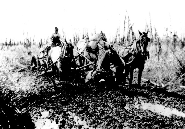
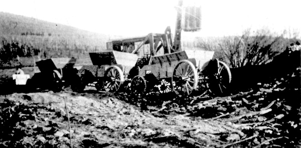

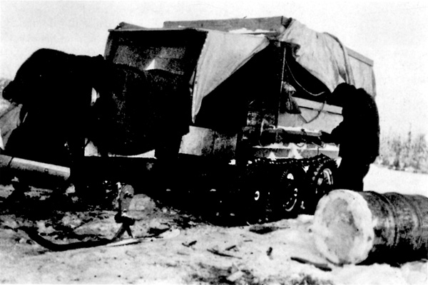
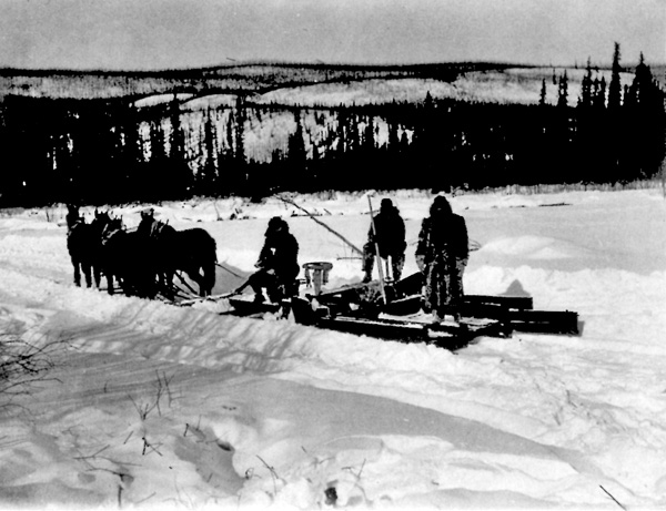
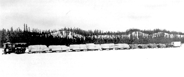
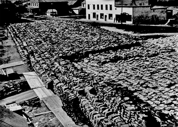
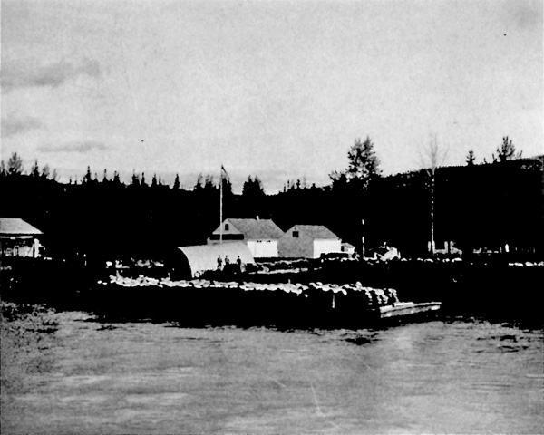
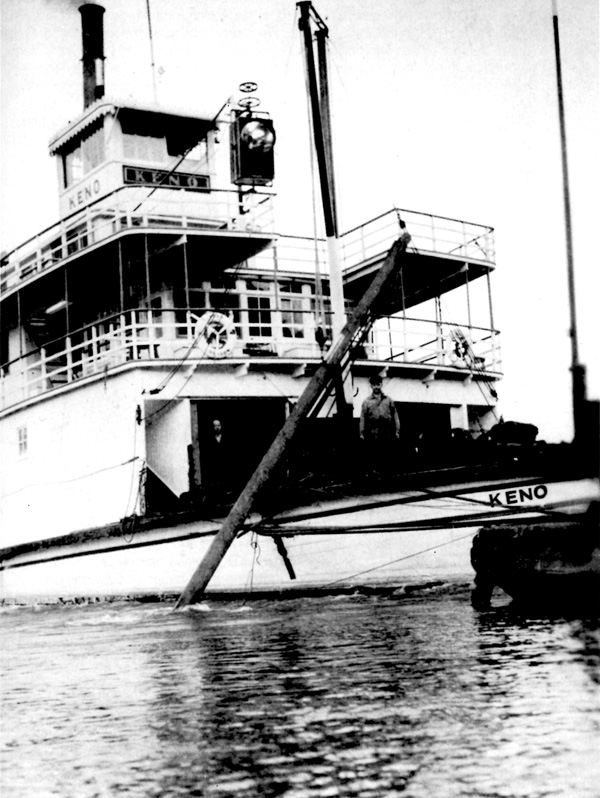
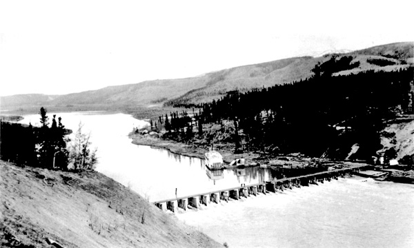

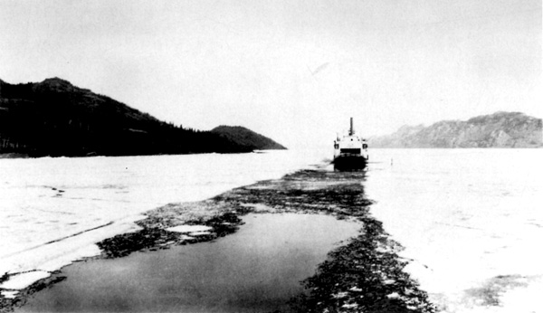
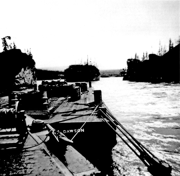
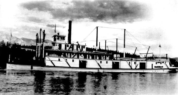
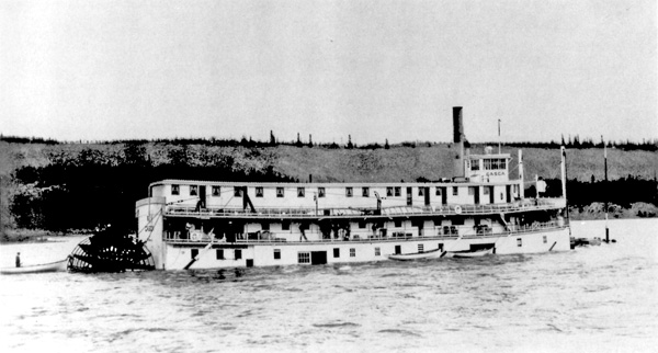
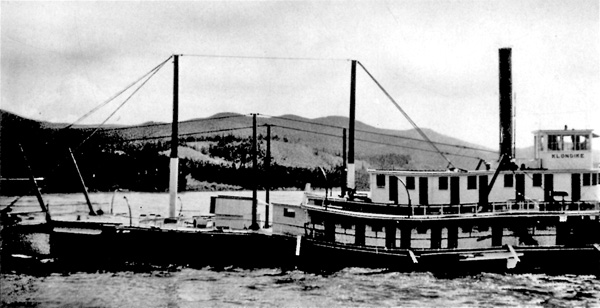
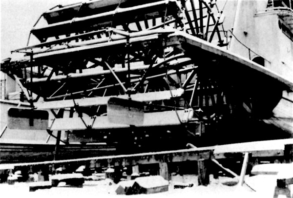
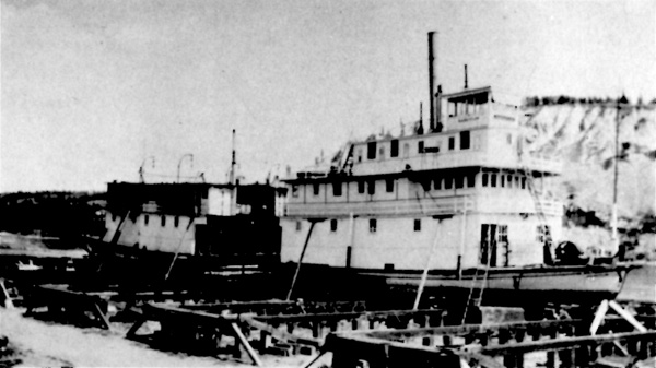
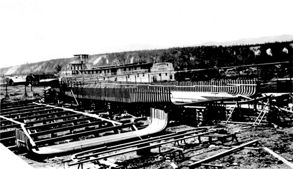
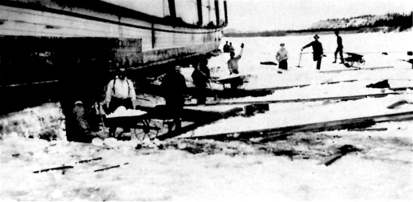
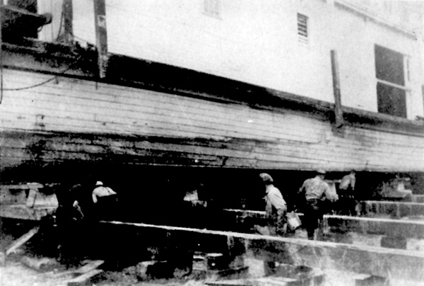
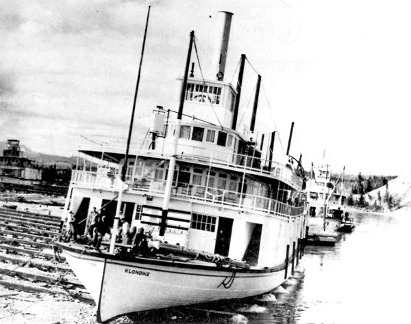
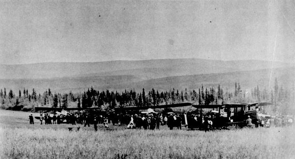
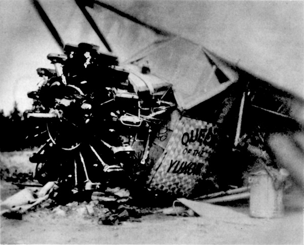
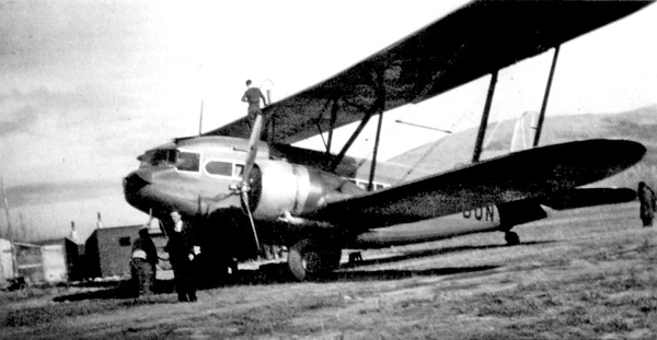
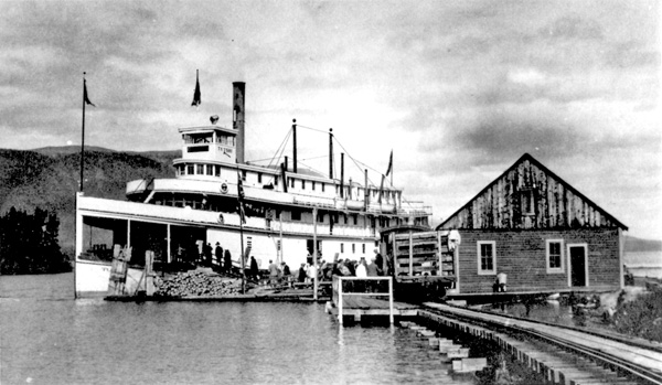
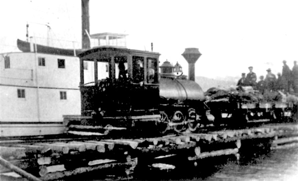
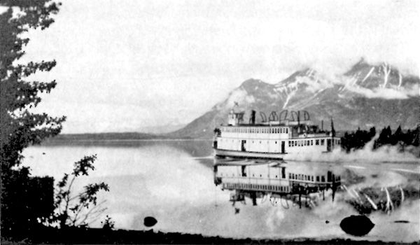
|
||||||||