 |
|
Canadian Historic Sites: Occasional Papers in Archaeology and History No. 19
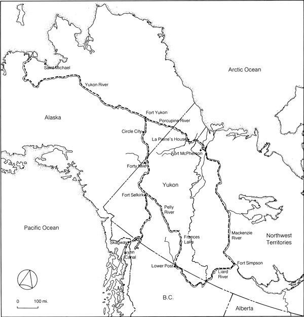
by Gordon Bennett The Pattern EmergesI The Yukon is a land of paradox: richly endowed and barren, enticing and forbidding. To some it conjures visions of treasure untapped, a promise unfulfilled and a future still to be realized; to others it symbolizes nothing more than the "land that God gave as Cain." Ironically, neither view is without validity, for what nature bestowed in munificence, geography conspired to make inaccessible. Situated in the northwest corner of North America and separated by an ice-packed ocean, two seas and a difficult overland and river route from Europe, the Yukon remained untouched by European expansion until the mid-19th century. Surrounded by a series of geographical barriers: the St. Elias Mountains and the northern Cordilleras on the southwest, the Cassiar and Rocky mountains to the south, the Mackenzie Mountains on the east and the Arctic Ocean to the north, the Yukon presented a formidable prospect. For centuries these natural obstacles effectively precluded immigration to the interior. Only the Yukon River, which rises 15 miles from the Pacific Ocean in northern British Columbia and runs two thousand miles through the Yukon and Alaska to the Bering Sea, offered relatively easy entry; yet even this fissure was a grudging concession, for the climate ensured that the river would be closed to navigation for almost eight months of the year and semiaridity helped to ensure that the river would always be shallow during the open season of navigation. The low temperatures and light precipitation were to make husbandry unfeasible. Finally, most of the region escaped the scourge of glaciation, a fact that for centuries preserved the ramparts and protected the resources from man.
II The white man was not the first to pierce the Yukon's natural defences. The Indian preceded him by thousands of years, by way of the land bridge that then permitted migration across the Bering Strait.1 Little is known of these Indians and their way of life before the arrival of the whites. After contact had been established, native culture was evaluated from a technological perspective and judged primitive. "Civilization," as understood by the early explorers and traders at least, was unknown to the Indian. While it is undeniable that the apparent simplicity of native culture was in some measure shaped by geography and climate, these factors were not primary for the white man ultimately shared the same region under the same conditions and, if his culture was at best that of the frontier, it was nonetheless technologically more advanced. What distinguished the culture of the Russian and the European in the North from that of the indigenous peoples were certain values on the one hand and on the other the existence of a transportation system which made possible provisioning and supply, as well as communication, with the outside.
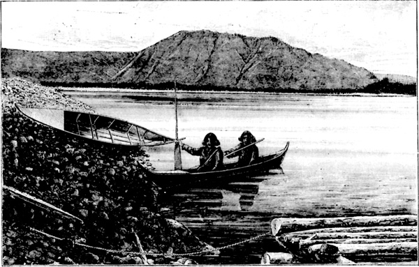
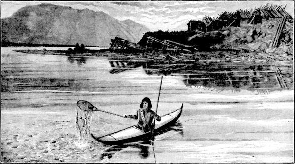
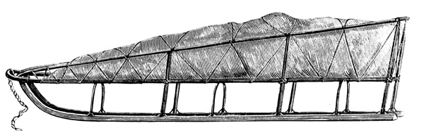
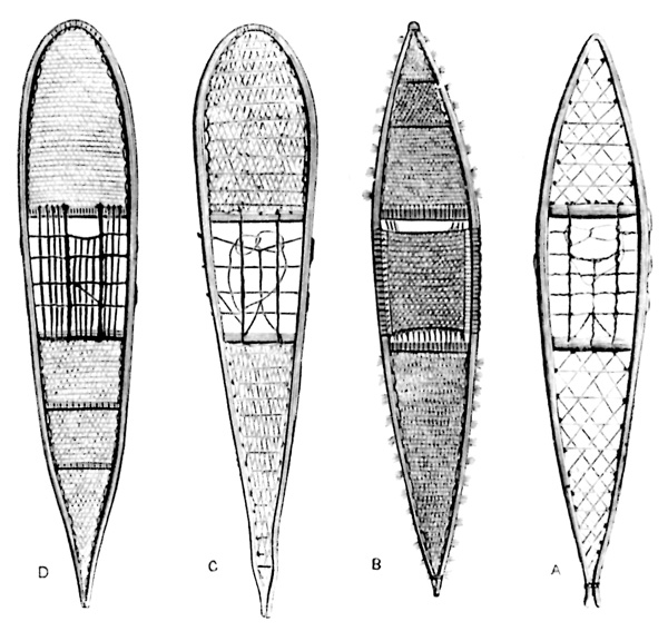
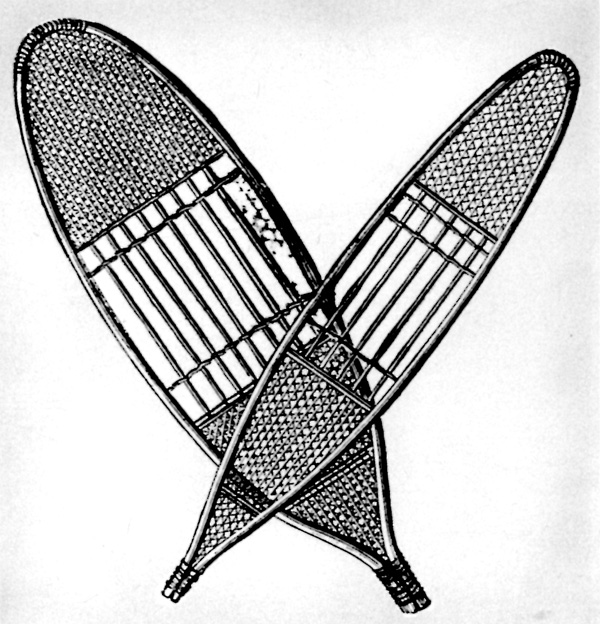
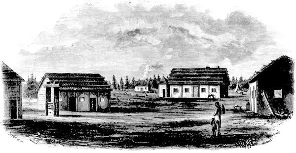
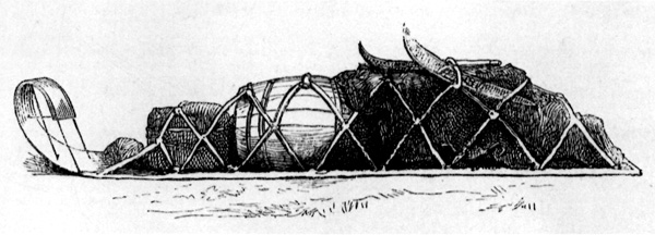
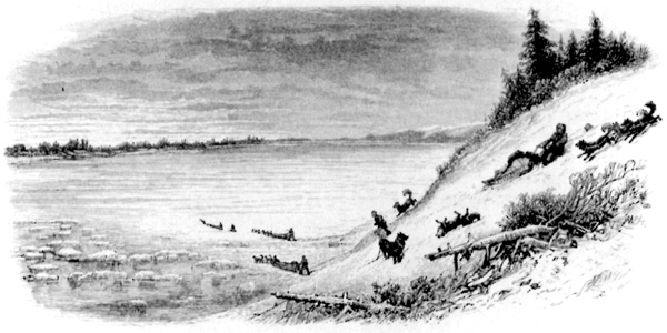
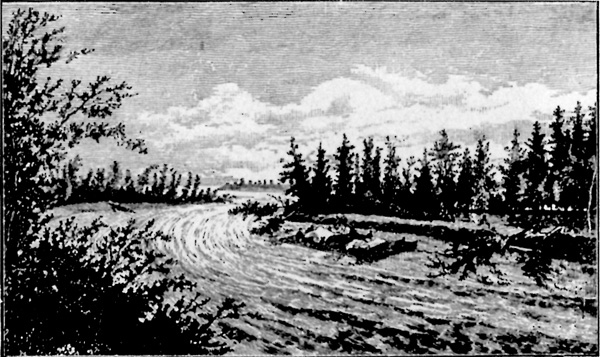
The distinction between a transportation system and the modes of transportation is important. A comparison of the forms of transportation used by both the Indians and the whites in the Yukon, at least until the introduction of steamboats on the Yukon River, reveals that both were similar. Like the whites, the Indians were dependent on the river during the summer months. With bark canoes, which provided the principal means of travel, the Indians enjoyed sufficient mobility to sustain their existence. Built by the women of each tribe, who stretched the bark over wooden frames and pitched the joints to make them waterproof, these canoes were propelled by either paddles or a pole.2 In winter transportation was by dog sled, toboggan or snowshoe. The sleds and toboggans were made of birch, the various components being lashed together with leather thongs. No nails or wooden pegs were used. The sleds were fitted with thin, broad runners designed to bend with the declivities of the snow. The runners, in turn, were shod with a thin veneer of bone and iced to reduce surface friction. The Indian sleds were light and fast and capable of carrying heavy loads over smooth ice. To assist the dogs pulling the sleds, the Indians generally preceded them and broke trail with their snowshoes.3 The climate established a seasonal pattern of transportation in the Yukon characterized by the alternating use of water and overland forms of travel that was to persist until the early 1950s. The effects of this dependence on the climate and the rhythm to existence which it produced were to have a marked influence on the history of the area. III The first whites to enter Alaska were the Russians. Though they never pushed far enough into the interior to cross the boundary that separated the Yukon from Alaska,4 they did establish a gateway to the Yukon which was to be of vital importance throughout the 19th century. That gateway was the Yukon River, via the port of Saint Michael, 70 miles north of the mouth of the Yukon. The Russians came in search of furs and in the process established a commercial empire in Alaska with a feudal society.5 The Russian monopoly went unchallenged until the late 1830s and the 1840s when the Hudson's Bay Company, pursuing a policy of westward expansion after their union with the North West Company in 1821 and making use of a series of posts on the Mackenzie River, broke through the barriers which had theretofore isolated the Yukon from British commerce. The fur trade, the magnet which drew the white men into the Northwest, hinged on two factors: the existence of fur-bearing animals and a network of water routes for transportation. The dependence of the fur trade on the water routes was critical since these routes made the Hudson Bay Company's penetration possible and prospective trading-post sites were chosen "largely on the requirements of water transportation."6 Dependence on water travel survived long after the Company had withdrawn from the Yukon; in fact, it characterized transportation in the Yukon until the 1950s when the last sternwheeler on the Yukon River was finally beached. The Hudson's Bay Company broke through the natural barriers that separated the Yukon from the Mackenzie District in a pincer movement, using the Mackenzie River as the source for all exploration west. In 1840 Robert Campbell was commissioned by the Company "to explore the north branch of the Liard to its source and to cross the height-of-land in search of any river flowing to the westward."7 In May of the same year, Campbell and a party of seven set out from Fort Halkett on the Liard and followed that river to its junction with the Dease. From there Campbell swung north to Frances River and on to a mountain lake, which he named Frances in honour of Lady Simpson. Beyond the lake he entered the Finlayson River, reached Finlayson Lake and portaged to another river which he called the Pelly, after the governor of the Hudson's Bay Company. He then retraced his movements and rejoined the main party at Finlayson Lake.8 Two years later, in 1842, Campbell established the first Hudson's Bay Company post in the Yukon at Frances Lake.9 During the next six years Campbell opened up the southeastern section of the Yukon for the Company, establishing another site at Pelly Banks, and explored the Pelly, Lewes and Yukon rivers. In 1848 he built Fort Selkirk at the confluence of the Yukon and the Pelly.10 In the meantime, traders of the Company had been active in extending the trade to the northern portion of the Yukon using the Porcupine River. John Bell, a chief trader, who had built Fort McPherson in the North West Territory in 1840, discovered the Rat River and explored the Porcupine to its mouth in 1842. In 1847 Alexander Murray was commissioned to establish a post at the confluence of the Porcupine and the Yukon. Leaving Fort McPherson in July of 1847, he proceeded to La Pierre's House where he embarked in the Pioneer to the mouth of the Porcupine. At the mouth of the latter river he selected a site for a trading post and build Fort Yukon.11 Though located in Russian America (later Alaska) just a few miles to the west of British territory, the commercial advantage of locating at the junction of the Porcupine and the Yukon outweighed diplomatic considerations in this remote area and Fort Yukon become the focal point for the Company's dealings in the northern Yukon.
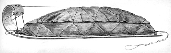
By 1847 the Hudson's Bay Company had established two water routes to the Yukon from the Mackenzie River. In 1851 Robert Campbell made his historic trip from Fort Selkirk down the Yukon River to Fort Yukon, thereby establishing that the Yukon and the Pelly were on the same watercourse.12 This discovery was of great significance. Posts in the southern Yukon had always been difficult to provision owing to dangerous travelling conditions on the Liard. With the discovery that the Pelly and the Yukon were on the same watercourse, the Liard route was abandoned in favour of the Porcupine.13 From 1852 until 1869, when the Hudson's Bay Company was expelled from Fort Yukon by the United States government, the Porcupine was the main gateway to the Yukon interior.14 The pursuit of the fur trade in the Yukon by the Hudson's Bay Company was at best a marginal enterprise. The limitations of the transportation system and the resulting high costs were factors that the Company was never able to overcome. These difficulties were exacerbated by the Indians' hostility to white incursion, a prime example of which was the destruction of Fort Selkirk by the Chilkats in 1852. However, occasional manifestations of open hostility by the Indians was secondary and in the case of Fort Selkirk, possibly a consequence of the inadequacy of a transportation system that made it difficult to supply the fort and which only served to entice the Chilkats to take strong measures to regain their historic monopoly over the trade of the southern interior. Within the Company itself there had been a continuing debate over the profitability of the Yukon trade. In arguing for the abandonment of the southern posts, one chief factor noted that losses were incurred from 1848 to 1850 at the Frances Lake, Pelly Banks and Fort Selkirk posts and that during its last year of operation (1851) Fort Selkirk showed a loss again.15 An examination of the transportation problems that plagued the Hudson's Bay Company illustrates the impossibility of conducting the Yukon fur trade on a profitable basis from the East. According to Innis, sleds employed by the Company in the Yukon were smaller than those used elsewhere with the result that furs had to be packed in smaller bundles.16 The isolation of the Yukon posts made provisioning difficult and response to changing Indian trade demands almost impossible. George M. Dawson, chief dominion geologist, later noted that it had taken seven years for the returns from Forts Yukon and Selkirk to reach the market. The course of trade was as follows: Goods. — 1st year, reach York Factory; 2nd year, Norway House; 3rd year, Peel River, and were hauled during the winter across the mountains to La Pierre's House; 4th year, reach Fort Yukon. Returns. — 5th year, reach La Pierre's House and are hauled across to Peel River; 6th year, reach depot at Fort Simpson; 7th year, reach market.17 As a result, the Company was forced to restrict the Yukon trade to furs of high value, a fact which adversely affected its competitive position with the Russians.18 With the expulsion of the Hudson's Bay Company from Fort Yukon in 1869, a phase of transportation history in the Yukon closed. During this phase two river routes had been opened up to the Yukon interior. Neither was to be of lasting significance. The very nature of the fur trade as practised by the Hudson's Bay Company discouraged settlement and with it the introduction of more highly developed transportation forms.19 The Company had employed the same conveyances as the natives, with minor modifications. Of these the "Hudson Bay Sled" and snowshoe were the most important. The former was, in fact, a toboggan nine feet long made from three birch planks held together by crosspieces. The load was carried in a large moose-skin bag lashed to the sled. The toboggan style was adopted because it was more suitable for carrying heavy loads than the conventional sled. Nevertheless, this adaptation in favour of carrying capacity necessitated the sacrifice of several useful features common to the more conventional style of sled. As a result, the Hudson Bay sled was hard to guide, difficult to take up a hill and practically impossible to keep on the trail when travelling along a hillside. Because the floor of the sled rode close to the surface, the load was subject to water and snow damage. Progress was slow unless travelling over hard-packed snow. With this in mind, the Company designed a special snowshoe for trail use. This snowshoe had a packing effect which facilitated the movement of the sled. The Hudson Bay snowshoe was small, 30 inches being the regulation length. It was pointed at both ends, the front being curved upward and fitted with a knob to break the crust. For other types of winter activity such as hunting, the traders used a larger snowshoe modelled after the "Kutchin" Indian style.20 Only at Fort Yukon, where two boats, 30 feet 8 inches long with 9-foot beams, were built in 1848, was any attempt made to introduce boats and these were limited to the movement of goods on the Porcupine River to La Pierre's House.21
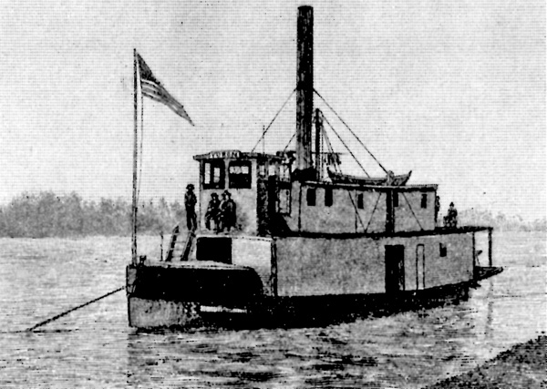
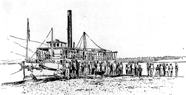
IV In 1867 the United States purchased Alaska from Russia. While most Americans tended to regard Alaska in much the same way as Voltaire had regarded New France,22 one enterprising group of traders turned its attention to the new American possession. The San Francisco firm of Hutchinson, Kohl and Company, drawn to the Northwest by the Pribiloff seal fishery, acquired the Russian trading posts and boats in the territory. In 1868 the firm filed articles of incorporation creating the Alaska Commercial Company.23 With the virtual withdrawal of the Hudson's Bay Company from the Yukon in 1869, the Alaska Commercial Company extended its interests to include the fur trade of the interior and quickly established a commercial monopoly over a region which included not only Alaska, but also the Yukon itself. Until 1894 when Inspector Charles Constantine of the North-West Mounted Police was despatched to the Fortymile district, the history of the Yukon and Alaska can be said to have been virtually identical. This period of Yukon history was characterized by two forms of economic activity — fur trading and prospecting. With each passing year, however, prospecting become the more important of the two. The Alaska Commercial Company retained its interest in the fur trade, but the trapping was done by Indians or prospectors who sought to supplement the small returns from their diggings. Unlike the Hudson's Bay Company experience, the two forms of economic activity proved to be relatively complementary under the aegis of the Alaska Commercial Company. The establishment of the Alaska Commercial Company in Alaska and the Yukon led to the abandonment of the old Hudson's Bay Company trade routes. After 1867 the principal gateway to the Yukon interior was the Yukon River via Saint Michael. The adoption of the old Russian trade route after 1867 had a profound effect on the development of transportation in the Yukon. It not only involved a significant change in access, but also made possible the introduction of steam-powered vessels — the first major technological innovation in the transportation history of the Yukon.24 The first steamboat on the Yukon River was the Wilder, a small craft employed by the Russian-American Telegraph Company.25 W.H. Dall, an American explorer, likened the vessel to an old-fashioned flatiron and remarked that it was "just about as valuable for the purpose required. Unable to tow anything, or to carry any freight, while in a breeze of any strength it was no easy matter to steer," the Wilder can hardly be said to have marked an auspicious debut for a form of transport that was to dominate Yukon transportation for almost a century.26 Regular river service was introduced in 1869 when the Alaska Commercial Company launched the sternwheeler Yukon and augmented two years later with the launching of the Western Fur and Trading Company's St. Michael. Both were small craft, 70 to 80 feet in length, 14 to 20 feet in width, with a draft of 3 to 4 feet. Fitted with powerful wood-burning engines, each boat was designed to push a barge when necessary, each barge having a maximum capacity of ten tons. The Canadian surveyor William Ogilvie, who had been commissioned to establish the 141st meridian for boundary purposes and who was to later enjoy a conspicuous place in the history of the gold rush, wrote that the Yukon "could make a round trip from St. Michael to any point in the vicinity of the boundary line in about a month, the upstream time being twenty days." In 1871 the Yukon went up the river as far as Fort Selkirk. Until 1898 when sternwheelers began to run on the upper, or Bennett-Dawson, section of the Yukon River, no sternwheeler ever went above the site of Campbell's old trading post.27 It was the fur trade that had lured the Alaska Commercial Company to the Northwest. By the early 1870s, however, a new interest was generated which was to overwhelm the trade in furs and almost totally replace it.28 This new interest was gold. The discovery of gold in California in 1848 precipitated a stampede to the West Coast the following year. After the first burst of activity in the California gold fields had passed and as individual mining methods were steadily superseded by more advanced forms of mining technology, the majority of those who had set out for the West Coast settled down to the less romantic but profitable pursuit of settling California. The rush to California had given birth to a breed of men, however, to whom the search for gold was to become a lifelong obsession. Beginning in the early 1850s, these men rushed to every new gold camp, only to abandon it when news of another discovery reached them. By the 1860s the trail of gold camps had led to the Cariboo district in British Columbia.29 The expansion of gold-mining activity in the West, beginning in California and culminating in the Cariboo, had followed a roughly northern course. This pattern of expansion suggested to some of the more speculative prospectors that there might be a belt of gold running north to south on the western lip of the hemisphere that had its source somewhere in the Yukon or Alaska. In the early 1870s these men began to trickle into the Yukon to test their hypothesis. Of these men, four stand out as major figures in the history of the Yukon: Leroy Napoleon "Jack" McQuesten, Al Mayo, Arthur Harper and Joseph Ladue. McQuesten, Mayo and Harper reached the north in 1873 via Fort Yukon and the Porcupine River. In 1874 they entered the employ of the Alaska Commercial Company.30 During the next 20 years they opened trading posts, prospected, and assisted other prospectors throughout the territory with supplies, credit, transportation and advice. Joseph Ladue joined them in 1882.
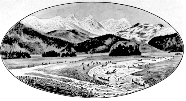
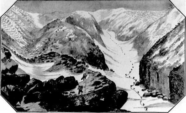
It might be said of each of these men that they were frustrated miners. None of them ever discovered the gold that had drawn them north, but they were not failures. Without them, as Pierre Berton has appropriately written, "the series of events that led to the Klondike discovery would not have been possible. Without the string of posts they set up along the Yukon, the systematic exploration of the river country could not have taken place."31 This string of posts, moreover, furnished a framework for the first internal transportation network in the Yukon. Excepting the major innovation in navigation that took place in the late 1860s, no significant change in the Yukon transportation system occurred until the early 1880s when a new route to the Yukon was opened up. Located at the head of Lynn Canal, this new gateway originated at Dyea, led over the Chilkoot Pass to the mountain-fed lakes in northwestern British Columbia and down the Yukon River. For years the Chilkat Indians had guarded the pass, denying the white man access in order to protect their trading monopoly with the Indians of the interior.32 In 1878 a prospector by the name of George Holt used the pass and is generally recognized to have been the first white man to successfully deny the Indian interdict.33 Two years later the pass was opened to all when the USS Jamestown used gunboat diplomacy to "persuade" the chief of the Chilkat Indians to allow free access to it. From 1881 the Chilkoot Pass became the main portal used by miners going into the Yukon.34 Movement over the Chilkoot Pass was difficult, the trail being a veritable obstacle course. The path over the summit, steep and rock-strewn, made it impossible to use pack animals for the through journey between Lynn Canal and the lakes on the other side.35 The Chilkat Indians, no longer able to restrain the whites from using the pass, turned the situation to their own advantage by taking up the profitable pursuit of packing prospectors' supplies over the summit.36 With the discoveries of gold along the bars of the Stewart River in 1886 and on the Fortymile in 1887, the influx of miners into the region increased in intensity. As a result, a pattern that had begun to emerge as early as 1882, when prospectors first began to use the Chilkoot Trail, was established by 1887. This pattern was to persist with only slight modification up to and including the gold rush of 1898. There has been an unfortunate tendency to associate everything pertaining to the Klondike gold rush with having been a product of it. Nowhere has this tendency been more misleading than in the history of the development of transportation in the Yukon. A cursory examination of what took place during the 1880s, with specific reference to the Lynn Canal gateway to the interior, reveals that the main outlines of the gold-rush transportation system had been laid long before 1897-98. In 1886 a trading post was built on the tidal flats at Dyea by John J. Healy. Here the prospectors debarked from steamers which had carried them up the Inside, or Inland, Passage, purchased their supplies and made arrangements with Healy for the packing of their possessions over the trail. Thus the first organized economic enterprise to serve miners going into the Yukon from the Alaska Panhandle predated the gold rush by 12 years. By 1887 Sheep Camp, three-quarters of the way up the Dyea trail, had been established as the main stopping-off point on the coastal side of the pass, just as it was to be during the gold rush.37 As early as 1887, prospectors were whipsawing timber and building boats at Bennett Lake for the trip down the Yukon River and William Ogilvie's observation, made in the same year, that the supply of lumber for boat building had become practically exhausted suggests that this had been going on for some time.38 The tent city of thousands that ringed the southern bank of Bennett Lake in the spring of 1898 may have shocked the newspapermen who were despatched by their publishers to report on the Klondike phenomenon, but to those who had been in the Yukon for some years it was only the culmination — surprising in its extent to be sure — of a process that had begun at least ten years earlier. In retrospect, the 1880s stand out as a decade of great progress in laying the framework of the gold-rush transportation system. For the first time accurate information was accumulated concerning transportation routes as a result of the explorations of Frederick Schwatka, an American army officer, and Canadians George M. Dawson and William Ogilvie.39 A portage road, replete with rollways and windlasses to transfer boats, was built in 1887 on the east bank of the Yukon River across from the present townsite of Whitehorse to bypass the Whitehorse Rapids.40 In the same year, Dawson notified the minister of the Interior that Edward Bean had obtained permission from the United States government to build a road over the White Pass, some six miles east of the Chilkoot, and reported the rumour that a railroad was to be built over the Chilkoot.41 Although Bean had petitioned the secretary of the Interior for a franchise to construct a trail over the White Pass, his request had been refused on the grounds that Congress was the only body empowered to grant franchises. Bean was not the last person to seriously contemplate a trail over the White Pass before the gold rush. At least two more unsuccessful applications for a franchise were made, one in 1888, the other by William Moore in 1891.42
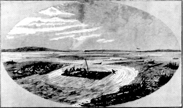
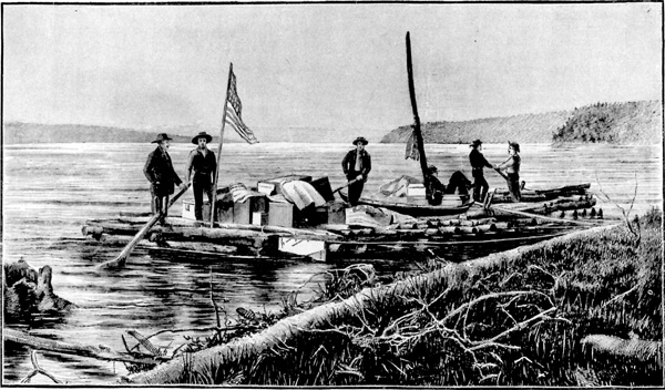
While none of these schemes bore fruit, they do suggest that the pre-gold-rush Yukon showed enough economic potential to justify speculative consideration being given to substantial improvements to the transportation system. Furthermore, they suggest that ambitious transportation schemes were not simply products of gold-rush hysteria. While it is important to bear in mind that charter and/or franchise applications do not necessarily prove serious intent on the part of the applicant, it should be noted that governments, not individuals, were the usual risk takers in the construction of "development" roads during the 19th century and that the absence of legislation providing for a franchise — and to an even greater extent the corollary subsidy — may well have been a factor in postponing a series of schemes that was economically premature.43 To serve the ever-growing human influx, sternwheeler operations on the lower river were expanded. In 1883 a small sternwheeler, the New Racket, was constructed. The Alaska Commercial Company built the Arctic, one of the first of the larger boats on the lower river (140 feet long, 28 feet wide, with a 6-foot hull), in 1889 and it, like its predecessors, made the Saint Michael-Fort Selkirk run.44 In 1892 the monopoly of the Alaska Commercial Company was broken with the formation of the North American Transportation and Trading Company, a Chicago-based firm with its Yukon headquarters at Cudahy. An immediate result was a reduction in prices and the supplying of better goods by both companies.45 Another significant consequence was the North American Transportation and Trading Company's decision to go into the navigation business. The Portus B. Weare, the first of the company's sternwheelers, was placed in service in 1892. A short time later the John J. Healy followed. Responding to the challenge of its new competitor and to the needs of the growing northern population, the Alaska Commercial Company added the Alice (1895) and the Bella (1896) to its fleet of river boats.46 Excepting the introduction of steam-powered vessels on the lower river, modes of transportation remained primitive between 1869 and 1896, just as they had been during the Hudson's Bay Company's presence. Canoes, rafts and sleds continued to be the principal forms of domestic travel, the birch-bark type of canoe giving way to cottonwood dugouts after 1869.47 Poling boats were introduced by the miners during the 1880s and used on the Yukon River and its tributaries. They were particularly well-suited to upstream travel. Long, narrow, and pointed at both ends, these craft were propelled by two men sinking poles through the water and pushing on the riverbed. At times the poles were augmented by a canvas sail.48 An important innovation in overland travel occurred during this period with the introduction of horses.49 The earliest record of horses in the Yukon dates from 1891 when Jack Dalton and E.G. Glave brought horses in over what was later to be known as the Dalton Trail.50 There is also evidence to suggest that horses were used infrequently at Dyea before this time, but the nature of the Chilkoot Trail prevented them from being brought into the Yukon profitably. Another factor limiting the use of horses was the lack of food. It was generally believed that native grass was not nutritious enough to sustain horses and the costs involved in bringing in hay were too high to make importation feasible. There was also some discussion as to whether horses could withstand the climate and, since it was felt that horses would have to be shod, it was believed that the iron shoes would freeze solid to the ice or else freeze the horses' feet. Despite these apparent drawbacks, horses were brought into Forty Mile in 1893 and were in general use at Circle City after 1894.51 However, the horse did not seriously challenge the status of the dog as the primary motive force in overland transportation during this period. V On the eve of the Klondike gold rush the Yukon interior was served by two transportation networks, each originating in Alaska: one on Lynn Canal, the other at Saint Michael. Each fulfilled a separate function. The former was the avenue of migration, the latter the highway of trade. In keeping with this functional nature, the forms of transportation for each were distinct. The lower river was the private preserve of the sternwheeler and the trading companies.52 The Lynn Canal, on the other hand, was atomistic in nature, serving individuals or small parties of prospectors who crossed the Chilkoot Pass on foot and travelled down the Yukon River system in small boats of their own construction. Interestingly enough, both of these networks were to retain their pre-gold-rush characters during the great stampede.
|
||||||||||||||||||||||||


|
||||||||