 |
|
Canadian Historic Sites: Occasional Papers in Archaeology and History No. 19
by Gordon Bennett Recession and RecoveryI Midsummer 1899: In Dawson, log cabins could be had for the taking as steamboat after steamboat, jammed from steerage to upper deck, puffed out of town en route to Nome. The saloon trade fell off; real estate dropped; dance halls lost their custom. Arizona Charlie Meadows announced that he would float his Palace Grand in one piece down the river to the new strike. Jacqueline, the dance-hall girl, complained that her week's percentage would hardly pay her laundry bill. In a single week in August eight thousand people left Dawson forever.... And so just three years, almost to the day, after Robert Henderson encountered George Carmack here on the swampland at the Klondike's mouth, the great stampede ended as quickly as it had begun.1 The facile conclusion has long been drawn that the end of the great stampede marked the end of the Yukon Territory. A popular conception persists that shortly after 1900 the Yukon somehow disappeared, like some North American Atlantis, only to reappear in the 1940s and 1950s when attention was turned to the construction of the Alaska Highway and man's insatiable appetite for natural resources once more kindled his interest in the North. In the interim, it is generally believed, nothing happened.2 Except for a handful of personal reminiscences which make no pretence of completeness3 and a number of studies pertaining to the Alaska Highway, this view has been reinforced by a paucity of written history for the post-gold-rush period. All but ignored interritorial historiography is that a number of significant themes and events shaped the course of Yukon development after 1900. II In the immediate post-gold-rush period the Yukon Territory entered an era of protracted economic decline that was to last, with only brief interruptions, until the 1950s. Although several factors contributed to this reversal in the territory's fortunes, it was the inherent instability of the gold-rush economy, not the exhaustion of the gold fields, which precipitated the decline. Interestingly enough, of the 250-odd million dollars that the gold fields ultimately produced, more than 75 per cent was taken out after 1900. What distinguished the gold rush from the post-gold-rush period was not the existence of gold, but the mode of mining peculiar to each. The tenfold increase in gold production that attended the gold rush was the product of a massive input of labour supplied by the Klondike stampede.4 This increase in the labour market added a new dimension to the economy — "sheer numbers of people demanding the amenities they had enjoyed in the south." As a result, a variety of service-oriented enterprises encompassing medicine and the law, business, commerce, newspapers and entertainment evolved.5 The pressures toward inflation, already loosed by the free-spending hysteria that overcame the gold camp, were given a powerful artificial stimulus by the regulation promulgated by the territory's first commissioner, James Walsh, that "no person was to come into the city [Dawson] who had not at least $750 in money or money's worth." Placing the population of Dawson at thirty thousand in 1898 and taking $1,000 as the average sum brought into Dawson by each individual, one official estimated that this "set free within a very small area the enormous sum of $30,000,000." This in itself was enough to propel an economic boom. At the same time, the mining industry and the demands of the local population gave a strong impetus to other industries based on lumbering and coal mining.6 Yet for all of these stimuli, the foundation upon which the gold-rush economy rested was fragile. As the rich, easily accessible gold deposits were exhausted, production declined and the population, no longer having the means to support itself, decreased. By 1902 the gold-rush economy, sustained in large part by rising gold production and a rapidly expanding gold population, had collapsed.7 As early as 1899 there were symptoms of the impending decline when many abandoned Dawson for the new gold fields in Nome, Alaska,8 but the severity of the decline was not clearly apparent until the early 1900s. By then most of the trading and transportation companies that had sprung up during 1898-99 had disappeared and by 1904 real estate values had plummeted to less than one-third their 1899 valuations. By 1904 considerable property was vacant on Front Street in Dawson and in the words of one observer, "undoubtedly. . . permanently vacant." Its depreciation, he added, "is so great as to leave it practically valueless except as to the material contained in the buildings." That summer "many substantial men . . . and many more of those who have constituted our floating population" left Dawson for Fairbanks, Alaska, and another chance at fortune. But the paradoxical legacy of the gold rush was not that people left the Klondike after 1899, but that many people remained. Those who did leave were in the majority, but their departure was predictable. They included those stampeders whose single motivation was, as J.R. Lotz has noted, to "clean up and clear out" and the old-timers who had gone to the Yukon long before news of the Klondike discovery reached the outside. Even as one government official was confidently noting the evolution of Dawson "from an uncertain, unstable and excited mining camp to a steady, permanent and prosperous community," the old-timers "began to get an uneasy sensation in their spines. It was as if the whole cycle of their experience was being repeated."9 These men had spent their entire lives living on the fringes of civilization, only to move on as civilization progressively encroached upon what they considered to be the last outposts of their freedom and independence. And now civilization had overcome Dawson. Like those who had been moved by the maxim "clean up and clear out," the old-timers recognized that their time to leave had come. But the end of the gold rush neither presaged the end of mining in the Yukon nor did Dawson follow the classic pattern of other 19th-century placer gold-rush centres and become a ghost town. It is more accurate to regard the post-gold-rush period in the Yukon as rather one of severe dislocation and readjustment to new circumstances than demise. The superstructure of the gold-rush economy had been both superficial and unstable and it disappeared. What followed was a rationalization and a consolidation of the Yukon's economic base. The period 1900-14 was not only one of profound economic change precipitated by a decline in production, it was Dawson's golden age as well. During that time anarchy gave way to order, ostentation gave way to studied elegance, and gambling houses, drinking parlours and prostitutes were gradually replaced by fraternal organizations, churches and schoolmarms. As was to be expected, the mining industry pointed the way. After 1901 the labour-intensive, "poor man's" methods of mining characterized by the pan, the rocker, the sluice, wood burning and the individual claim were superseded by capital-intensive techniques based on the dredge, hydraulic monitors, steam thawing and concessions. This conversion from primitive extractive methods to highly sophisticated extractive techniques based on machinery gave the area a stability and a security it had never known before. The impact of these changes on the transportation industry was not so great as might be initially supposed. So long as gold mining over an extensive area continued and so long as a population large enough to support and be supported by the mining industry remained, transportation was a basic need. This need did not end in August 1900 when the residents of Dawson memorialized the governor general for better transportation facilities; rather it was only the beginning.10 This is not to suggest, however, that the aftereffects of the gold rush bypassed the transportation industry. As was noted above, most of the transportation companies that had sprung up to serve the needs of the gold-rush population during 1898-99 had abandoned the field by 1901. Nevertheless, the quality of transportation in the Yukon did not deteriorate after 1901. If anything, it improved as attempts were made to reduce the cost-price squeeze and open up new areas for economic exploitation in the territory.
III The Yukon River continued to be the most important transportation artery in the Yukon between 1900 and 1914 just as it had been through the fur trade, early prospecting and gold-rush phases of Yukon history. The one significant modification that occurred during this period was the completion of the White Pass and Yukon Route railway from Skagway to Whitehorse in July of 1900. With the completion of the railway, a practical alternative to the lower river route via Saint Michael came into existence. But the emergence of this alternative did not diminish the river's role; instead, it enhanced it and gave the river a greater utility. The river itself remained the heart of the Yukon transportation system. For this reason, an understanding of its peculiar qualities is a necessary prerequisite to any examination of the evolution of transportation in the territory. The Yukon River, 1,993 miles in length, is the fifth-largest river in North America.11 Authorities differ as to its exact source, some designating it as Lindeman Lake, others citing the Nisutlin River and Summit Lake.12 From its source, the Yukon River follows a tortuous course to its mouth on the Bering Sea off Norton Sound in Alaska. For half of its length the river flows in a northwesterly direction through the central plateau of the Yukon Territory. At the edge of the Arctic Circle it shifts abruptly to the southwest as if deflected by the inrushing waters of the Porcupine, and from there it flows on inexorably to the sea. The peculiar ambulations of the watercourse — here like a corkscrew, there like the furrows in a field — are suggestive of the contradictions which characterize the river itself. Inordinately circuitous and difficult to navigate, the river nonetheless provides an inland waterway through the heart of Alaska and the Yukon, the only fissure in an otherwise impregnable land mass. Long by any standard of measurement, the river is shallow through most of its extent, the consequence of a semiarid climate. Swift on the upper section, the river rapidly loses velocity as it spills onto the Yukon plateau, and from there meanders lazily to the sea.13 Unlike any other river of comparable economic importance, certain sections of the river on the Canadian side of the international boundary line have different high-water periods during the year. The section of the river between Marsh Lake and Fort Selkirk, formerly known as the Lewes, and the section below White River reach their high-water marks in July and August, after the solar energy of the summer months has melted the glacial ice that feeds them. On the other hand, those sections below the river's snow-fed tributaries, the Teslin, Pelly and Stewart rivers, have their high-water periods in late spring, after the annual spring break-up of the ice.14 The railway eliminated the obstacles to navigation at Miles Canyon and Whitehorse, thereby furnishing the necessary conditions for a successful challenge by the upper route for sternwheeler traffic on the Yukon River.15 After 1900 the upper river virtually superseded the lower river as the primary gateway to the interior and by 1915 its traffic monopoly was practically complete. Despite this weighting of the balance at the expense of the Saint Michael route, however, serious impediments to navigation on the upper river between Whitehorse and Dawson existed. On Lake Laberge, the opening of the navigation season was delayed each spring while sternwheeler crews anxiously waited for the ice on the lake to rot and break up, some two weeks after the ice on the river below the lake had gone out.16 It was not until the early 1920s that this problem was overcome and the navigation season prolonged by the successful damming of the headwaters on the lake. At Five Finger Rapids, approximately 150 miles below Laberge, four massive knuckles of rock jutted out the water, ready to smash the sternwheeler whose unwary pilot had failed to hug the east bank. Below the Five Fingers were the sunken reefs of the Rink Rapids. At Hellsgate Rapids, just above Fort Selkirk, the island-studded river appeared to flow in greater volume along the east bank, but the pilot who failed to use the navigation channel near the west bank did so at his peril.17 Below Kirkman Creek, a small tributary that was located above the confluence of the White and Yukon rivers, deposits of detritus caused the navigation channel to shift throughout the season. These were the major obstacles to transportation, apart from the climate, on the upper river and this was the highway that was to be internal life line of the Yukon Territory until 1950. Ownership of the railway placed the White Pass and Yukon Route in an excellent position to exploit the transportation potential of the upper river route to Dawson. This potential was recognized as early as 1899 by the directors of the company who had had either the perspicacity or the good fortune to charter the company as a general transportation line which included the right to build wharfage and docking facilities.18 With the collapse of the gold-rush economy and the resultant withdrawal of most of the transportation companies that had evolved to meet the demands of the gold-rush population, the way was cleared for the White Pass and Yukon Route to enter the river transportation business.
The decision to set up a river division within the company was precipitated by the general chaos which prevailed on the river during 1900. As the sole transportation company providing service from tidewater at Skagway to the head of navigation on the Yukon River at Whitehorse, all traffic going into and out of the Yukon via the upper route went by the White Pass and Yukon Route railway. This led to innumerable problems at the transfer point at Whitehorse where through shipments of goods were split up, Customs papers lost, goods stolen on the boats . . . . Many of the boat owners were not responsible financially, so that the passengers with through tickets and the goods owners with through bills of lading naturally preferred to make their claims against us [the White Pass and Yukon Route], leaving us in our turn to recover from delinquent boat owners — if we could.19 These difficulties convinced the first president of the company, S.H. Graves, that in "self-defense we must organize our own river service."20 The company's plight was not nearly so severe as Graves's statement would tend to imply. To be sure transhipment mix-ups gave cause for concern. But the company was also aware that the setting up of a river division would result in the elimination of any serious competition by virtue of the company's ownership of the railway. With Tancred's approval, a river division was subsequently organized and styled the British Yukon Navigation Company.21 During the winter of 1900-01 the company built a shipyard in Whitehorse and a repair yard in Dawson.22 Three boats were purchased from the Canadian Pacific Railway Company, the machinery and fittings from which were installed in new boats built at the British Yukon Navigation Company's Whitehorse shipyard.23 On 1 May 1901 the British Yukon Navigation Company acquired the fleet of its largest potential competitor, the Canadian Development Company, and shortly thereafter extended its operations to Atlin, British Columbia.24 The economic vicissitudes of the post-gold-rush period had a serious impact on the numerous transportation companies plying the Yukon River. After 1901 most of them withdrew from the field, unable to compete with the White Pass and Yukon Route's complementary railway and sternwheeler service. A number managed to sell their boats to the British Yukon Navigation Company and by 1903 all but three boats on the upper river were owned by the White Pass subsidiary.25 But though the post-1900 economy had serious implications for the transportation companies that had sprung up to serve the demands of the gold rush, it was of minor consequence for the Yukon transportation system as a whole and was not without its benefits. The British Yukon Navigation Company enjoyed a period of relative prosperity between 1901 and 1914 although this prosperity occurred at the expense of competitive conditions on the upper river. When the conversion to capital-intensive mining took place after 1903, the transportation legacy of the gold rush, in the name of the White Pass and Yukon Route, played a vital role. Without the complementary facilities of the railway and the post-gold-rush sternwheeler fleet offering through rates from tidewater to Dawson, the transition to capital-intensive mining would likely have occurred on a much reduced scale. By 1907, having pursued an aggressive policy of eliminating common carrier competition, the British Yukon Navigation Company enjoyed a monopoly on the upper river limited only by a single independent company operating one sternwheeler between Whitehorse and Dawson. In the same year, wharfage rents in Dawson were brought into line with prevailing conditions by reducing them 50 per cent.26 While transportation on the upper river was adapting itself to the changing transportation requirements of the territory and exhibiting a visible trend toward monopoly, a similar process of adaptation was occurring on the river below Dawson. Before 1901 the lower river had been the principal supply route to the Klondike gold fields. After the completion of the railway, however, Skagway replaced Saint Michael as the main port of entry to the Yukon. The impact of the railway coupled with the collapse of the gold-rush boom were such that no transportation company on the lower river showed a profit for its operations during the 1901 navigation season.27 To strengthen the competitive position of the Saint Michael route and to offset the depression that hit the transportation industry on the lower river after 1900, the Alaska Commercial Company, theretofore the largest trading and transportation company in the Yukon and Alaska, merged with the International Marine Company and Alaska Goldfields in 1901. The new firm's merchandizing and transportation operations were then separated into two distinct companies, the Northern Commercial Company and the Northern Navigation Company. Shortly thereafter the Northern Navigation Company bought out the Seattle-Yukon Transportation Company. In 1906 the North American Transportation and Trading Company, the second-oldest company in the Yukon, sold its sternwheelers and Saint Michael terminal to the Merchants-Yukon Transportation Company.28
The elimination of competition through merger prolonged the life of the Saint Michael route. As well, the lower river possessed certain competitive advantages which, if not sufficient to turn the tide of Yukon trade away from the upper route, at least deferred the lower river's demise. To begin with, larger boats could be used on the lower river. Second, in supplying Fairbanks, lower-river companies effectively cut the length of their supply lines to Dawson by half. Third, some of the largest stores in Dawson were owned by transportation companies on the lower river whereas the White Pass and Yukon Route had no merchandizing outlets.29 Finally, the "exorbitant" freight rates charged by the White Pass and Yukon Route alienated many Dawson merchants. As one of them declaimed, "look into Lower R[iver] shipping, the less we ship White Pass, the better for us."30 But the repeal in 1904 of the law that had previously permitted the free shipment of Canadian goods from a Canadian port to Dawson via Saint Michael came as a serious blow to the transportation companies on the lower river.31 By 1912 business in the Yukon had contracted sufficiently to precipitate an open fight between the upper and lower river for the right to supply Dawson. The contestants were, appropriately enough, the Northern Navigation Company and the British Yukon Navigation Company. Much to the delight of the residents of Dawson, the first round in the contest was a rate war. The British Yukon Navigation Company then carried the fight into Alaska by putting two of their vessels, the Alaska and the Yukon, on the lower river to connect with Fairbanks. The Northern Navigation Company retaliated "by contracting on a continuous basis with heavy shippers for freight to be shipped via St. Michael." The prospect of mutual bankruptcy finally drove both companies to the bargaining table and on 10 April 1914 it was announced that the White Pass and Yukon Route, acting for its wholly owned subsidiary, the British Yukon Navigation Company, had purchased the entire river operation of the Northern Navigation Company.32 By 1914 the upper route had established hegemony on the Yukon River. Although water transportation was primarily confined to the Yukon River during this period, there was some activity on the tributary streams. One of the more interesting features of this activity was the role played by government in diverting attention from the main watercourse to the tributaries through a policy of direct involvement in river navigation. Behind this policy was an attempt to diversify and decentralize the economy of the territory by opening up new areas for exploitation. In 1906 the Canadian government assisted prospectors going into the Pelly region by giving them free passage on Royal North-West Mounted Police steamers. This policy was expanded in 1907 when the commissioner of the territory announced that the government was prepared to subsidize transportation companies making trips up the Pelly and Stewart rivers. Although the subsidies were discontinued after 1908, they achieved the desired effect and by 1909 light-draft steamers were operating on the Stewart, Pelly and Hootalinqua rivers. In 1909 as well, the Side Streams Navigation Company was formed. This company operated a small sternwheeler that supplied the White, Stewart and Pelly rivers and the Fortymile River up to the canyon.33 While the opening up to navigation of the tributaries of the Yukon River did not result in the discovery of any new large mineral deposits, the side streams trade was an important addition to the meagre transportation facilities that had previously served the small communities on these tributaries. The sternwheeler underwent certain modifications in design and engineering following the establishment of the British Yukon Navigation Company. In large measure this was because the physical characteristics of the upper river required boats of shallower draft and narrower beam than those that operated below Dawson. This requirement was not unique to the Yukon River; it obtained on virtually every major waterway in Canada and in the United States as steamboat service was extended upriver. Nor was it as dramatic as the change that had occurred on the Mississippi where the sternwheeler replaced the sidewheeler as traffic moved upstream. Outside of one reference which has never been verified, there is no record of sidewheelers having ever operated on the Yukon. Thus the evolution that took place on the Yukon was one of degree, not kind. The development of the Yukon steamboat paralleled the development of boats on rivers west of and tributary to the Mississippi — rivers that were narrower and shallower than the Mississippi. Considered as a prototype, the sternwheeler was more suitable to these smaller waterways since its rear-mounted paddlewheel and relatively flat-bottomed hull were conducive to operating in shallow water and the absence of sidewheels gave it a narrower beam than the lower Mississippi steamer and hence the ability to negotiate narrower channels. The stern-mounted wheel provided other advantages as well: it gave grounded steamers an opportunity to wash away sand from the hull by reversing engines; it was protected by the hull from snags and sweepers, and because it was designed for low water, it permitted the sternwheeler to land virtually anywhere along a riverbank without special docking facilities. The sternwheelers that were built by the British Yukon Navigation Company were patterned after the "swift water" boats that operated on the Snake, Willamette and Upper Columbia rivers, rivers that more closely approximated travelling conditions on the upper Yukon.34 They were designed to carry heavy cargoes downstream on a very light draft and to make the return trip upstream with light freight and fuel with the paddle wheel still "sufficiently immersed to take up the power of the engines without racing." This was accomplished by providing the boats with tremendous backing power so that sharp turns, narrow channels and swift currents could be negotiated without having to depend on the rudder alone. This backing power was not only used to reduce the speed of the boats on downstream trips, but to aid in steering as well.
To compensate for the "slide" of a single rudder, the company devised a system utilizing six rudders, three behind the paddle wheel and three between the wheel and the hull, that were controlled by a steam steering gear. This system permitted the efficient use of the steering apparatus whether the boat was going backward or forward. As a result, the steering of these vessels did not depend "as in other craft, on having steerage way; but on the movements of the stern paddle-wheel."35 While the boats used by the British Yukon Navigation Company differed in size and capacity during this era, they did not, in most cases, exceed 170 feet in length or 35 feet in width. The larger ones carried between 200 and 250 tons of cargo on a draft of 4 feet. When empty they drew approximately 18 inches. On the downstream run they averaged 15 miles per hour, covering the distance between Whitehorse and Dawson in two days. The upstream voyage took four days. The boats had electric generators and were provided with spot beams to permit night travel during the period following break-up and just before freeze-up. The beams were only used on the upstream trip, however, because the swift current on the downstream run made night travel too hazardous. During the summer when darkness was not a problem, the boats were in operation 24 hours a day. Freight was carried on the main deck for ease of handling, with the result that the main deck came to be known as the "freight house." The engine room and boiler were also located on the main deck, in the stern and bow respectively.36 These boats carried up to 150 passengers who were accommodated on the observation and upper decks. Passenger compartments were called staterooms, a term that originated with the Mississippi steamboats where the custom had been to paint the names of various states over the door to each room. Accommodation on the upper deck was generally of a higher quality than that of the observation deck and the term "Texas," which also derived from the Mississippi, was used to designate it. Above the Texas deck was the pilot house. Each boat was provided with a dining room and liquor was served.37 The British Yukon Navigation Company sternwheelers burned wood for fuel. On the downstream trip only a limited quantity of fuel was required for "backing" and steerage. Upstream these vessels consumed between one and one-half and two cords of wood per hour. Each fall, wood contracts were let to various individuals living along the riverbank who cut and stacked timber at regular intervals on the sternwheeler route for use the following summer. In 1904 the company conducted experiments with local coal, but its quality was not high enough to justify converting the sternwheelers into coal burners.38 Despite the many innovations in sternwheeler technology that occurred as a result of the formation of the British Yukon Navigation Company, certain characteristics of the Yukon River continued to plague navigation. Shifting channels, bars and reefs did not disappear with modifications in the technology of the sternwheeler and efficient operations continued to demand experienced boatmen and pilots who were adept at "reading the water" — recognizing the shifting channels and other impediments to navigation by breaks in the surface and by the colouring of the water.39 Several techniques were developed in order to assist the movement of the sternwheelers through difficult sections and several improvements were made to the river itself. Of the former the most generally employed was a modification of the "tracking" technique known as "lining." To track a boat, a number of men, proportional to the weight of the boat and the strength of the current, walked along the bank with ropes or track lines, moving the boat by pulling these ropes in the desired direction.40 Lining a boat followed the same principle, but applied machinery to the task instead of muscle. When a sternwheeler reached a section of the river where lining was necessary, a row boat with a flexible cable was despatched to a point where the cable could be made fast. (Later, permanent cables were installed where necessary.) If a well-embedded tree were not available, a "deadman," or heavy log, was set. With one end of the cable attached to the deadman and the other end tied to the steam capstan on the boat, the sternwheeler hauled itself through on the cable. When additional power was required, a "strop" was put on the cable and a "purchase tackle" was attached to the capstan, a procedure that had the effect of increasing the power of the capstan from two- to fourfold.41 Because of the shallow water and shifting channels, sternwheelers often went aground. When this occurred the backing powers of the paddle wheel were utilized in an attempt to wash away the bar. If this tactic were unsuccessful, resort was made to lining or "sparring." Each boat was equipped with two spars, the ends of which were placed under the hull of the boat, one on each side when sparring was required. Once set, the spars were held in position by swinging derricks. Atop each spar was fastened a three-sheave block held in place by a heavy wire strop, while corresponding blocks were made fast to the port and starboard sides of the ship. Tackle ropes were then run from the spars to the steam capstan on the fo'c'sle. As the capstan drew the ropes, most of the boat's weight was transferred to the spars. This done, the engines were started and the boat lurched ahead "like a sick grasshopper," the procedure being repeated until the boat was off the bar.42
With the conversion to capital-intensive mining, the building of the Klondike Mines Railway and the displacement of the lower river by the upper route, new methods of heavy freight transport were developed to handle machinery that could not be loaded onto the deck of a sternwheeler. Beginning in 1903, scow-assisted sternwheeler transport became extensive, only to be replaced the following year by small barges. Large barges were introduced in 1905 and served to increase carrying capacity to some 450 tons during high water. After that the pushing of barges became an integral part of the movement of freight on the Yukon River. Given the river's shallow and crooked nature, this necessitated the use of "jackknifing" in order to negotiate sharp turns. To jackknife a boat through a turn, the barge was angled over the shallows while the sternwheeler was kept in the channel.43 Another practice adopted by the company, in this instance to extend the navigation season, was to winter a sternwheeler at the foot of Lake Laberge. The ice on the river below Laberge broke up before the ice on the lake went out and wintering a vessel at the foot of the lake added about two weeks to the short navigation season. Employing men to look after the sternwheeler during the winter months increased the costs of an otherwise seasonal operation and the charges incurred by the cartage of freight over the ice of the lake to supply the sternwheeler offset many of the advantages that were gained by extending the navigation season.44 The feud between transportation and the river was not an entirely one-sided contest. The river, too, was forced to concede some of its natural superiority as men sought ways to make it more amenable to the movement of traffic. Between 1900 and 1914 the government sponsored a series of river improvements — at times independently and at other times in league with the navigation companies operating between Whitehorse and Dawson — to eliminate the most difficult obstacles to navigation on the upper route. One of the first of these improvements was the construction of a breakwater by the Department of Public Works at the head of Lake Laberge in 1899-1900. The breakwater proved inadequate, however, when in 1902 the ice carried a portion of it away and the channel reverted to its old course.45 This section continued to be a problem requiring annual work until the British Yukon Navigation Company built a dam at Marsh Lake in the early 1920s. In 1900 a portion of the rock outcropping at Five Fingers was blasted in order to widen the east channel. Two years before, the stampeders had installed a windlass there to line their boats through, an improvement that had its limitations since it was restricted to use by small scows. In 1904 a cable was laid through the Five Fingers to assist sternwheelers on the upstream run. For years the Department of Public Works worked on the Five Fingers, dynamiting the rock formation until the channel was widened by some 20 feet.46 In 1900 one official reported that "during low water heavily loaded steamboats touch the bottom of the river" at Hellsgate. In 1902 the government built a dam there to deepen the channel. By 1908 the dam had deteriorated to such a degree that it was necessary to refill it and improve the breakwater.47 In the same year, the British Yukon Navigation Company expended a government appropriation of one hundred thousand dollars removing the rock and reef obstructions at Rink Rapids.48 Taken together, the innovations in sternwheeler technology, the utilization of a variety of navigational techniques and the river improvements greatly reinforced the vital role played by the sternwheeler in the economy of the territory between 1901 and 1914, a role that had had its awkward beginnings as early as 1866 and was to last until 1950. Like the mining industry to which it was so closely tied, river navigation underwent a painful period of readjustment during the first 14 years of the century. When the gold rush ended, most of the river transport companies on the upper river ceased operation, but the collapse of the gold-rush economy did not herald the end of the sternwheeler, A new company emerged which for the first time had come to the Yukon to stay.49 The effects of this commitment were far-reaching. For the first time boats were built in the Yukon and the sternwheeler was adapted to suit the limitations of the river. Carpenters, engineers and crews, if only in small numbers, were given employment where before there had been none. The investment of the White Pass and Yukon Route in its transportation facilities meant that the company had a practical interest in the economic development of the territory that was not simply restricted to the high-grading type of exploitation that had prevailed before. Finally, the company's commitment gave to the Yukon a degree of stability and assurance unknown during the gold rush. The sternwheeler was more than a carrier of men and supplies into and out of the territory, It was an active participant in the mining conversion. It supported the timber industry by burning wood for fuel and united the small communities that hugged the riverbank. By 1914 it was an integral element in the life style of every Yukoner.
IV From the day it was completed, the Skagway-Whitehorse railway proved to be a remarkably profitable enterprise. One contemporary alleged that the entire cost of construction was liquidated during the company's first year of operation. In 1901 and 1904, two years for which figures are available, the company's net earnings were $1,500,000 and $451,000 respectively. Until 1912 the White Pass and Yukon Route returned a dividend at the end of each fiscal year to its investors, a return that reflected the intensive utilization of the railroad's facilities. Through 1911 as many as three trains a day, except Sunday, were run between Skagway and Whitehorse during the summer months, while in the winter, when the river was closed to navigation, there still existed sufficient demand for the company to operate an average of six trains a week.50 The Yukon winter provided the railway with its severest test during these years. Each November the annual struggle between the railway and the elements commenced, a struggle which lasted until April of the following year. And every year the winter extracted its toll from roadbed, rolling stock and train crews. No other railway on the continent pushed through such extremes of winter climate in 110 miles. From Skagway to Bennett high winds and heavy snows prevailed. On the section between Glacier and Bennett the snow depth often reached 25 feet and severe winds frequently drifted it 25 more. From Bennett to Whitehorse the snowfall decreased as temperatures plunged, sometimes reaching 60 degrees below zero. In the spring, snow slides and washouts wreaked havoc with the safe movement of passengers and freight and demanded the engineers' constant vigilance. To deal with these conditions, the company maintained two rotary snow-plows and erected a series of massive snow fences on the Canadian side of the summit to keep the line clear, but even these precautions did not eliminate the need to use train crews armed with no more than shovels to free the tracks after a particularly heavy snowfall.51 Apart from its "life line" function to the Yukon interior, the White Pass and Yukon Route exploited to advantage one of the two new resources that were discovered during this period. The first comprised the summer tourist trade, a trade that was to increase significantly over the years, becoming a mainstay of the railway during the desperate years of the 1930s. The lure of the Klondike was still powerful during this period, as the popularity of books on the gold rush demonstrated, and, moreover, was more than matched by the spectacular scenery that ringed both sides of the rail line between Skagway and Whitehorse and highlighted the sternwheeler excursions operated by the company to Atlin, British Columbia. Arrangements were made with the coastal steamship companies operating into Skagway to exploit this colourful history and splendid scenery. On the two-day stopovers at Skagway made by Canadian Pacific Railway steamers, the White Pass and Yukon Route ran tourist excursions into the interior, while on the one-day stopovers scheduled by the Alaska Steamship Company and the Pacific Steamship Company, the White Pass and Yukon Route operated special return-trip excursions to Bennett Lake.52 The second resource to be exploited was the copper deposits contiguous to Whitehorse. As early as 1897 several outcroppings of copper had been reported by prospectors stampeding to the Klondike and in 1898 the first claim was staked. For the next nine years exploratory work and occasional shipments of copper ore were made, but poor transportation facilities based on a wholly inadequate road system pushed costs to prohibitive levels. In 1907 production was increased substantially, reaching a level of 3,530 tons. In the same year the White Pass and Yukon Route decided to build a spur line from MacCrea, seven miles south of Whitehorse, to the Valerie, Arctic Chief, Grafter, Best Chance, Spring Creek, Pueblo, War Eagle, Copper King, Rabbit's Foot and Anaconda copper properties. Construction was begun in 1907 and continued through 1908. A sharp decline in production in 1908 followed by the cessation of production in 1909 resulted in a construction stoppage for 16 months. The failure of these mines during 1908-09 has been attributed by one writer to "the high freight rates charged by the White Pass and Yukon Route railway and the inadequacy of transportation facilities between the mines and Whitehorse."53 Work resumed on the 12-mile spur line in 1910 and the final four miles were completed to the Pueblo property in August. Beginning in 1911, daily ore trains were operated on a year-round basis. A reduction in the White Pass and Yukon Route freight schedules in 1912 was a significant factor in bringing the mines back into production. Production increased at a rapid rate during World War I following a rise in the world price of copper, but the cessation of hostilities depressed the price of copper, and brought into focus once more the delicate balance between transportation and profitable mineral production in the Yukon. Like the gold rush, the First World War camouflaged the basic problems that underlined the Yukon economy. Inflation and increased demand more than compensated for the high costs of production and transportation over the short term. Yet the gold rush and the war were events of short duration and once the specific demands they had engendered disappeared and normality returned, the cost-price dilemma reappeared in high relief. After the war, copper production practically ceased and the spur line was abandoned.54
The adverse effect of transportation costs on the successful pursuit of enterprise in the Yukon was not restricted to the nascent copper industry. The experience in the Klondike district, while different in one essential respect from that of the Whitehorse copper mines, reflected the same basic transportation problems. What distinguished the former from the latter was not the nature of the transportation burden, but its distribution. In the latter case, transportation costs had been borne directly by the copper industry as a result of a small, producer-oriented population and the bulk characteristics of the mineral produced. In the Klondike the transportation costs were borne by the entire community. The reason for this was simple. In the case of copper, the standard of value was price per ton, while with gold, value was measured in ounces. Whereas in the copper industry the transportation costs were borne by the outgoing traffic, in the Klondike the transportation costs were borne by the incoming traffic and as a consequence, the whole community was affected — producers, by virtue of the need to pay higher wages in order to compensate for the higher cost of living, and consumers, who covered the transportation charges in the price they paid for each product they purchased.55 Grievances, real and imagined, against the schedule of freight rates published by the White Pass and Yukon Route were a constant refrain during this period — and indeed have remained so to the present day. The railway did not effect a massive reduction in transportation costs; rather it made transportation faster, easier and more reliable.56 Apart from the criticism of tariff schedules that sprang from legitimate complaints, the White Pass and Yukon Route's virtual monopoly on traffic into the interior made the company more vulnerable to attack than would have been the case had competitive conditions prevailed. After the collapse of the gold-rush economy, the population of the Klondike district declined. This decline was followed, in turn, by a corresponding decline in business. "As a result... attempts were made to reduce costs and particularly costs of transportation." There followed a period of agitation for a reduction in the freight rates charged by the White Pass and Yukon Route. As early as 1901, the company was ordered to lower its rates by the dominion government. Continued economic contraction after 1901, however, offset the immediate benefits of the reduction and attacks on the company's rates increased in intensity. In 1905 the Dawson Board of Trade argued that the future of the territory depended on transportation costs being low enough to work profitably the remaining low-yield gravels and it condemned the White Pass and Yukon Route for its "extremely exorbitant freight and passenger rates [which it is able to charge] by reason of an unjust monopoly . . . [thereby] injuring the entire business interests, [and] hampering and retarding the . . . development of . . . mining." Citing evidence that three-eighths of the territory's production was consumed by transportation costs, the board demanded that the company either be ordered to halve its existing rate schedule or that the government subsidize a competing line. This resolution attracted the support of the Young Men's Liberal Club in Dawson and the commissioner of the territory.57 Yet despite this widespread support for the Board of Trade recommendations, the resolution was not acted upon by Ottawa. An indication of the exorbitant tariff charged by the White Pass and Yukon Route is suggested by a comparison of various commodity costs and the freight rates charged for the transport of these items between Skagway and Whitehorse in 1910. In several instances the freight rates exceeded the wholesale cost of the product. The high tariff schedule can be partially explained as owing to the remoteness of the territory from the major centres of supply. Nevertheless, it is also true that the directors of the White Pass and Yukon Route recognized that the days of the "fast buck" in the Yukon were over and they followed a conscious policy of "getting all that they could, while the getting was good." The shareholders extracted every last possible profit from the operation, oblivious to the needs of the Yukon and to the detriment of the physical facilities of the railway. In two actions against the company, management was charged with corruption. Finally, in 1911 the Board of Railway Commissioners ordered the White Pass and Yukon Route to reduce its freight rates by one-third.58 An appeal to the Privy Council instigated by the company, however, resulted in the granting of a new hearing. At the rehearing the board reversed its first decision and instructed the White Pass and Yukon Route to make a voluntary rate reduction.59 The company accepted this order and lowered its rates approximately ten per cent.60 Reaction to the reversal of the board's first judgement was swift within the territory. George Black, the commissioner, wrote that the reversal "has not had a tendency to encourage prospecting in the territory" and emphasized that the question of transportation costs, with special reference to the White Pass and Yukon Route, was "a matter of the utmost importance to all persons prospecting and mining in the Yukon; in fact, to all inhabitants of the territory, as all lines of business are absolutely dependent on mining."61 V Transportation in the Klondike district, based as it was on the horse, the dog and a hodge-podge network of poor roads and trails, seemed wholly inadequate to handle the traffic requirements of the region after 1901.62 The conversion to capital-intensive extractive techniques and the eruption of a number of communities on the gold-bearing creeks created the need for a form of transportation — more reliable on the one hand and more capable of moving heavy freight and machinery on the other — to satisfy the changing transportation requirements of the district. As had previously been the case on the Panhandle access route to the territory, the solution to the problem of traffic movements was found in the construction of a railway. As early as 1897-98, serious consideration had been given to a proposal to build a railway connecting Dawson with the communities that were springing up on the placer creeks. In July of 1899, this proposal was acted upon and the Klondike Mines Railway Company, with its head office in Ottawa, was incorporated. Under the terms of the act of incorporation, the railway was to originate in Klondike City, across the Klondike River from Dawson, skirt Bonanza and Dominion creeks to Indian River and return to Dawson via the east bank of the Yukon River. Between 1899 and 1903, when construction actually began, the location of the line underwent several changes. The "loop concept" established by the act of incorporation was superseded by another plan to locate the railway from Klondike City to the headwaters of the Stewart River a distance of some 85 miles, a plan that was superseded in turn by the promoters' decision to run the line from Klondike City to Sulphur Springs.63 The elimination of Dawson from the promoters' plans elicited a variety of protests from that quarter. William Ogilvie, in a letter to the minister of the Interior, expressed incredulity at the selection of Klondike City rather than Dawson as the terminus, citing the former's poor steamboat landing, absence of wharfage and warehouse facilities and lack of good land suitable for development and expansion purposes as reasons why Klondike City should not be chosen. Why Klondike City was chosen over Dawson can probably best be explained by noting that one of the promoters, Thomas O'Brien, owned a substantial amount of property there. O'Brien, moreover, had already demonstrated a facility for using transportation projects as a means to fast money, as the Pioneer Tramway Company debacle clearly showed. One of the most colourful figures of the Klondike's first decade, O'Brien was the proprietor of a brewery in addition to his other interests and he played an active role in the political squabbles of the period, oddly enough as a reformer.64 As protests over the terminus mounted in 1902, the promoters of the railway — O'Brien, W.W. Parsons and E.C. Hawkins — agreed to appear before the Dawson city council. As a result of this meeting, the promoters were persuaded to designate Dawson as the terminus and a franchise was conferred on the Klondike Mines Railway Company for the laying of track and the building of a station on Front Street in Dawson. The series of miscalculations, beginning with the locational and terminal difficulties which had taken four years to sort out, continued into 1903 when for the first time a considerable amount of grading was done and four miles of track were laid and subsequently abandoned. By September of 1905, however, the first of two sections of bridge over the Klondike River was completed and work was well advanced on the second. Then a new problem, this time over the right of way, appeared. Injunctions obtained by the claim owners on Bonanza Creek forced the company to abandon construction on that section. The fear, previously expressed as early as 1901, that the right of way of the rail line would interfere with a large number of working claims, had materialized. Mindful of the crisis that now existed, the federal government despatched a representative of the railway commission to make a full investigation into the matter.65 Once the controversy over the right of way had been sorted out, the railway was quickly completed. Three locomotives were purchased from the White Pass and Yukon Route and by November 1906, trains were operating on the 31-mile line between Dawson and Sulphur Springs via Grand Forks. The total construction cost of the narrow-gauge railway was estimated at two million dollars. Under the terms of an agreement signed on 25 May 1906 the Klondike Railway qualified for a government subsidy.66 After the railway was completed, the horse-drawn stages that had previously run between Dawson and Grand Forks were discontinued. Service to the creeks tributary to the rail line was provided by daily passenger stages and freight wagons operated by the railway company.
Unlike the White Pass and Yukon Route railway, the Klondike Mines Railway encountered severe financial difficulties from the very beginning. After 1906-07 the company abandoned winter operations for reasons of economy. In 1909 the directors reported that expenditures exceeded revenues by 100 per cent and petitioned the territorial council for financial aid. The council responded by granting assistance for a period of two years. Nevertheless, it was apparent by 1909 that placer mining could not sustain the railway much longer and, as the general manager of the Klondike Mines Railway Company put it, "the future of the railway hinge[s] on [the] development of quartz mining." But quartz mining never progressed beyond the optimistic appraisals that were made for it and by 1913 the railway's operations were curtailed to the 12-mile section between Dawson and Grand Forks. Finally, in July of 1914, the company abandoned operations completely.67 An analysis of the failure of the Klondike Mines Railway underlines one of the many problems involved in any study of the Yukon. Superficially, the company's failure could be attributed to the economic decline that characterized the period from 1900 to 1914. However, assuming the promoters felt (as they must have) that the railway could make a profit, even as late as 1904 when construction could have been abandoned, and taking into account the fact that between 1907 and 1914 gold production exhibited a moderate but uninterrupted upswing, it seems clear that the reasons for the failure of the Klondike Mines Railway Company are not to be found in declining gold production but rather in the nature of gold mining itself.68 The conversion to capital-intensive mining which the railway facilitated reduced the need for transportation of the type provided by a railway. The railway relied upon continuous, revenue-producing operation in order to show a profit whereas capital-intensive placer mining in the Klondike required rail service on an irregular basis. The conversion to machine-orientated mining, moreover, was concentrated in an area adjacent to the railway's right of way. The acquisition and consolidation of individual claims into concessions, an integral part of this conversion, led to a decline in population in the creek communities served by the railway and was followed by a coincident decline in transportation revenues. In the end, the very dredges that the railway had helped to transport to the creeks proved to be its nemesis. When quartz mining, the development on which many in the Klondike had pinned their hopes for the future, failed to materialize as a satisfactory alternative to placer mining, the railway's fate was sealed. VI After 1900 the importance of roads and trails as a transportation factor increased enormously. The period when inflated prices and wages had compensated for inadequate domestic overland transport disappeared with the passing of the gold rush, and the construction of new roads and the improvement of old ones marked a deliberate attempt on the part of the territorial authorities to reduce transportation costs to a level commensurate with new economic conditions. Road building in the Yukon was complicated by three things: the nature of the territorial economy, the climate and the terrain over which roads were located and from which material was taken to build the roads themselves. Because the economy during the period 1900-14 was based on a single nonrenewable resource that was easily exhausted, many roads became obsolete shortly after they were built. As the frontier of mining activity expanded, especially in the Klondike district, new roads were required to link the new working properties with Dawson, the transportation and supply hub of the region. In general, the territorial authorities were responsive to the demands for new roads of this type and increased expenditures for road construction "in order to keep pace with the new conditions and assist in the rapid development of our mining interests" were made as a matter of course.69 But where roads were required for exploration and prospecting purposes with no guarantee that any discoveries would in fact result, government assistance was negligible, in keeping with the peculiar concept of laissez faire characteristic of the times. Another problem directly related to the territorial economy concerned the location of roads. Typically, a road was built to follow the path of least resistance, in most cases a creek bed, where maintenance costs were generally higher as a result of poor drainage, but where the cost of construction generally was low. While it might have been more expedient in the long run to build roads along the hillsides, other considerations outweighed the advantages to be gained from doing so. Construction costs would have been increased enormously. In the Yukon, where economic prospects dimmed between 1900 and 1914 and where the life span of a road depended on the richness as well as the concentration of a mineral deposit, the risks were too great to justify this added expenditure. Because the mineral deposits and the techniques of extraction were generally of the placer type, the deposit tended to be "worked out" much more rapidly than a lode deposit of comparable value. Given this built-in obsolescence, quantity rather than quality came to be the determining factor governing policy. The soundness of this approach was vindicated by the fact that road locations were constantly being modified to meet the changing needs of the mining community. Since roads were built to serve the mining industry, not vice versa, the location of a road was altered whenever it came into conflict with the location of a working claim.
The Yukon winter was not as serious an obstacle to road transport as might be initially suspected. In fact, road conditions were poorest during the spring and fall with the result that in July 1902 the territorial council passed an ordinance restricting vehicles to two horses between 15 April and 31 May, and 15 September and 31 October, and stipulated the use of four-inch tires on heavy wagons to prevent road damage.70 Hard-packed snow furnished the Yukon road system with its best surface of the year, facilitating the movement of people and supplies as well as the principal agents of motion, horses and dogs. After 1900 a network of "winter trails" was developed to supplement existing wagon roads. These trails were 75 to 90 per cent cheaper to build than conventional roads, requiring only the removal of brush and trees, and snow providing the surface.71 They furnished remote communities off the water routes with better access to Dawson during the winter than at any other time of the year. The adverse effects of winter on the regular roads occurred during the spring, when the spring runoff turned roads into virtual swamps, sometimes causing slides and washouts. It was not until asphalt became a practical alternative to gravel at a much later date that winter proved to be a serious deterrent to road rehabilitation and construction. Apart from the economic factors that governed policy, the most serious obstacle to road construction involved the terrain over which roads were built. The existence of permafrost required techniques of road construction that were quite different from those that were used south of the 60th parallel. Permanently frozen ground, or permafrost as it is commonly called, lies under a layer of overburden known locally in the Yukon as "muck." This overburden acts as an insulator, protecting the frozen ground from the heat of the sun's rays and effectively inhibiting melting. If removed as a preliminary to the preparation of a roadbed, the permafrost will melt, causing a softening of the subgrade and making for an unstable road surface. Fortunately, the economics of road building between 1900 and 1914 generally precluded any ambitious attempt to remove the overburden and therefore permafrost did not prove to be a serious problem. In cases where the overburden was removed inadvertently or through ignorance, the subgrade could be repaired by re-covering the exposed permafrost with an artificial overburden of brush and vegetation. While road builders in the Yukon learned through trial and error not to tamper with permafrost, those involved in the construction of the Alaska Highway did not have the benefit of this experience. As we shall see in a later chapter, one of the major problems encountered during the construction of the highway derived from a lack of knowledge concerning the nature of permanently frozen ground. Along with permafrost, certain soil properties geologically characteristic of the Yukon added to the already difficult task of road construction. When available, gravel was used for road surfaces. Gravel was not always possible to obtain, however, forcing road contractors to substitute whatever was available, glacial mud, clay or decomposed schist. None of these alternatives were particularly satisfactory. Clay and glacial mud were adequate so long as the road was so drained that water could not combine with them. When it did, the surface became a quagmire, practically impassable. Decomposed schist, on the other hand, lacked binding sediment and required constant grading and maintenance to keep it up.72 Ideally, wagon roads were constructed on a stable earth base covered with broken stone or gravel, the former being preferred. Once the surface had been laid, it was graded. Heavy grading required six to eight horses. If the roadbed were well drained, the road could handle heavy traffic with minor maintenance. On swampy ground, depressions and muskeg were corduroyed and covered with earth. This type of road, unlike the gravel type, required continuous maintenance because the earth surface deteriorated rapidly under heavy use. Corduroy was also used on main thoroughfares where gravel was not accessible. Timber for bridges and culverts was cut from native spruce and lasted for eight to ten years under stress. Wagon roads varied in cost from $1,500 to $3,300 per mile, substantially more than the $250 to $350 per mile expended on winter trails.73 Because of the climate, the terrain and the economics of road construction, maintaining the territorial road system was as important a factor in the overland transportation system as the construction of roads themselves. Roads were poorest in the spring, a result of winter icing and the spring runoff. To counteract winter icing, road crews cut and maintained ice trenches during the winter to concentrate the water and to prevent, so far as was possible, damage to the road. In addition to this, ice formations or "glaciers," as they were also called, were cut and the roads were kept plowed. During the spring, maintenance crews were at their busiest: protecting roads from the spring runoff; removing snowdrifts, snowslides and other debris from the road surface; opening up culverts and waterways, sometimes by steam thawing; diverting water away from roadbeds to prevent washouts, and repairing damage resulting from water sluicing. Yet despite these preventive and cleanup measures, the arrival of spring continued to be attended by a general deterioration of the territorial roads. As one official observed, "the very conditions which put roads in bad shape will hinder any steps being taken towards their permanent improvement until such time as the snow is melted and the ground thawed." During the summer, maintenance crews repaired ditching, replaced gravel, regraded road surfaces and built up shoulders and soft spots. Bridge cribbing was ballasted or renewed and decking was replaced when necessary.74
The innovations in mining technology that occurred on a large scale after 1903 added a new dimension to the maintenance problem. Hitherto, maintenance crews had concerned themselves almost exclusively with those problems resulting from the action of natural forces. The effect of hydraulic monitors and dredges on the contour of the land, however, exacerbated the already large task involved in maintaining the road system. Tailings from both operations changed existing drainage systems and buried roads. Problems of this nature were especially acute on the Bonanza Creek road where tailings filled water channels, producing winter icing and spring washouts.75 Between 1900 and 1914 some fourteen hundred miles of road were constructed in the Yukon Territory. The majority of these roads were built to give access to groups of working claims and to link small communities with the closest supply centres. As a general rule they were built to complement river transportation routes. In only a few isolated cases were roads constructed for what would now be called development purposes.76 Geographically, roads were of two types: intradistrict roads and interdistrict roads. The former were built within each of the mining districts established by the Mines Branch of the Department of the Interior (the Dawson or Klondike, Duncan or Mayo, and Whitehorse districts). These roads had a regional rather than a territorial significance, their function being determined by the special requirements of the individual district in which they were built. The interdistrict roads, on the other hand, were those that connected one mining district to another. In terms of mineral production and population density, the Klondike district was the most important district during this period and it was there that road and trail construction was concentrated. Before the Klondike district was provided with an adequate network of roads and trails, however, a solution to the problem created by Dawson's location had to be found. Cut off from the centres of mining activity by the Klondike River to the south and by the Yukon River to the west, Dawson required substantially improved connections over both before a satisfactory road programme could be undertaken. The first step toward a solution to this problem was taken in 1900-01 with the construction of the Ogilvie Bridge over the Klondike River. The bridge's 155-foot steel span replaced the cable ferry that had previously carried traffic across the river. Once completed, road construction proceeded vigorously. By 1914 the Klondike district was covered with a network of roads serving the main creeks and their tributaries. Of these, the principal were the Ogilvie Bridge road, the Bonanza-Indian River road, the Hunker-Dominion road, the King Solomon Dome-Sulphur road and the Klondike road. Stages and freighting outfits operating out of Dawson used these roads to supply the stores on the creeks and to deliver mail and newspapers to the people who lived there.77 Between 1906 and 1914 the Klondike Mines Railway competed with roads contiguous to its right of way, but the economic difficulties that plagued it and the curtailment of its winter operations after 1907 resulted in the railway having only a negligible effect on road transportation in the district as a whole. Another region for which Dawson acted as a transfer point was the Sixty Mile mining district, located on the west side of the Yukon River. Although the gold rush had resulted in a rapid decline in the importance of this area, prospecting and mining had continued there, especially on Glacier and Miller creeks. In order to afford improved communication between Dawson and these creeks, a cable terry was built across the Yukon River at Dawson in 1902.78 The cable ferry was an ingenious expedient applied to the problem of crossing rivers in the Yukon where economic circumstances did not justify the erection of a bridge. Until the end of the Second World War when roads rapidly superseded water as the primary highways of transportation, the cable ferry was the most common form of river crossing in the territory. A relatively simple device, the cable ferry consisted of a steel cable strung between two towers on each side of the river. A scow was attached to the cable with a sliding bridle tied to two cleats, one near each end of the same side of the scow. By adjusting one side of the bridle with a tightening or a loosening action, the scow could be angled into the current so it would travel in the desired direction, the current providing the motive force.79 All traffic moving west of Dawson was taken across the river on the cable ferry. The scow had a six-horse—one-wagon capacity. When the cable ferry could not be operated safely — generally at the beginning or at the close of the navigation season — a canoe was used instead.80 The erection of the cable ferry resulted in an increase in the volume of traffic over the river. In 1902 a pack trail that had been cut the previous year from West Dawson to Glacier was brought up to the standard of a "passable" wagon road. Increased mining activity in the area over the next two years was followed by the construction of a good wagon road in 1904. This new wagon road, in turn, had a salutary effect on mining. During the winter a sled trail was used to connect Glacier and Dawson.81
Gold was discovered on Duncan Creek in the Mayo district in 1898. The discovery did not immediately attract many miners, but as the frontier of mining activity expanded after 1900, some who had failed to locate profitable claims in the Klondike and some who had already exhausted their claims there began to trickle into the Mayo area. In 1906 a rich silver deposit was uncovered on Galena Creek, about five miles west of Duncan.82 As these discoveries attracted more and more miners, pressure mounted for the construction of roads to meet the increasing transportation requirements of the district. Between 1903 and 1906 the government built roads to connect the town of Mayo with Duncan Creek, Mayo Lake with Gordon Landing and another road along Highet Creek. Other roads that were built before 1906 were built by the inhabitants themselves.83 No overall plan existed whereby Dawson and Mayo were to be connected by road. Sections of road were built wherever and whenever a need existed, the need being defined by the requirements of the mining industry. Despite this rather haphazard approach, a winter road joining the two centres was completed by 1904. The first link was forged in 1902 with the construction of a winter trail between McQuesten, located at the confluence of the McQuesten and Stewart rivers, and Gordon Landing. In 1904 Barlow and McQuesten were joined by a short branch road. In the same year a winter trail was built along Flat Creek, east of the Barlow divide, to the Klondike River. The Flat Creek winter trail joined two sled roads; one on Allgold Creek, the other on Jansen, that ran to Hunker and Dominion creeks respectively. An alternate route was completed in 1906-07 when a 58-mile road was built from Mayo to Clear Creek to connect with a 20-mile stretch of road between Clear Creek and Barlow that had been built in 1902. Between 1907 and 1914 three more wagon roads were constructed: the Klondike River-Flat Creek road, the Jansen Creek-Clear Creek road and the Minto-Galena Creek road. A number of roads were built in the Whitehorse district between 1901 and 1914. As was the case in the Klondike and Mayo mining districts, these roads were built to serve the needs of the mining industry. What distinguished them from those roads that were built in the Klondike and Mayo districts, however, was that Whitehorse district was the only one in which the extraction of base metals rivaled that of precious-metal production. The first roads to be constructed in the Whitehorse district were to the copper mines adjacent to the Whitehorse townsite. In 1902, roads were built to the Grafter and Copper King properties. Rising production and the discovery of additional deposits after 1902 resulted in the extension of these roads to the War Eagle and Arctic Chief mines in 1907. Unlike roads that were built in placer-producing areas where the preponderant traffic was incoming, the movement of traffic over roads serving the base-metal mining industry was more balanced, involving large shipments of outgoing ore. As a result, transportation facilities had a much more direct bearing on the economics of base-metal mining than was the the case with the placer type of operation. Not only was the relation between freight rates and profits more pronounced, but also roads and vehicles designed to higher standards in order to withstand heavy use were required. In part it was the failure of the available transportation facilities to meet these demands — and this includes the White Pass and Yukon Route spur line to the copper mines as well as the road system — that resulted in the curtailment and eventual cessation of copper production. While the degree of mining activity in the Whitehorse district was not sufficient to justify road expenditures of the size made in the Klondike district, several roads were built to facilitate prospecting and mining. In 1902 a road was built from Mason Landing on the Hootalinqua River to Livingston Creek. Two years later a wagon road was built to Kluane Lake from Mile Post 31 on the Overland Trail. During the next two years roads were built in the Wheaton and Watson River areas and a short access road was constructed around Windy Arm. Other roads were built off the Overland Trail between Whitehorse and Dawson, notably the Thistle Creek road in 1907 and the Coffee Creek-White River trail in 1913. A road was constructed from Whitehorse to Carcross which complemented the facilities already provided there by the railway. In 1912 a road was built from Carmacks to the Tantalus coal mine. In the pre-gold-rush period, the annual freeze-up of the Yukon River had been a source of potential discomfort rather than a cause for great concern. The population was small, stable and known. Managers of the various trading posts scattered along the river were able to predict the needs of the communities that they served and order and receive the winter supplies that were required before the close of navigation. The men engaged in prospecting had been genuine pioneers, accepting the fact that life in the North usually meant belt-tightening in the winter and perhaps only one mail delivery a year. Before winter drifting was adopted, many had left for the outside on the last boat, an annual ritual that alleviated the problem of accumulating provisions for the winter months. With the stampede of 1897-98, the supply organizations that had previously been adequate to the task of winter provisioning proved totally deficient. No longer were resident trading-post managers able to predict winter requirements; the incredible influx into Dawson made all calculation impossible. Furthermore, the stampeders of 1897-98 expected amenities that they had enjoyed in more southern climes and many of the old-timers, their previous life styles foresaken forever by the infectious hysteria nurtured by the rush, discovered that they wanted them as well.
In light of these new conditions, a winter link to a supply centre on the outside was essential. The closest was Skagway and until the construction of the railroad the only route was over the frozen ice of the Yukon River by dog team. Apart from the obvious limitations imposed by the use of dog teams and sleds over a supply line that stretched for some 500 miles, the Yukon River was closed to all forms of transportation for two months of the year, in the fall before the river froze and in the spring when the ice was melting. During these two months there was no communication with the outside world.84 In 1899 the Yukon Overland Express and Transportation Company received a charter from the territorial government to build and operate a wagon and sleigh road from Bennett Lake to Dawson, complete with branch roads and relay stations. A primary reason behind the government's interest in seeing such a road constructed was the need to materially improve postal service between the territory and the outside. When the Yukon Overland Express and Transportation Company abandoned the Bennett Lake-Dawson road project without ever having commenced construction, the winter mail contract for 1899 was awarded to a man named Richardson, who assigned it in turn to the Canadian Development Company. During the winter of 1899-1900 the Canadian Development Company used dog teams to move mail and light express between Whitehorse and Dawson, gradually replacing the dogs with horses the following year. In 1901 the White Pass and Yukon Route bought out the Canadian Development Company in order to get the mail contract for its sternwheelers. The movement of mail, an almost totally ignored factor in northern transportation, was a stable and highly profitable source of revenue. An indication of its importance is suggested by the name chosen by the White Pass and Yukon Route to designate its winter sleigh operation, "The Royal Mail Service," a name that owed far more to economic realities than might be at first suspected.85 The acquisition of the Canadian Development Company and the operation of a winter transportation route between Whitehorse and Dawson was not the first time the White Pass and Yukon Route had engaged in winter transportation. Valuable experience had already been gained through the operation of the "Red Line Transportation Company" between Lindeman and Bennett lakes during the construction stage of the railway in the winter of 1899-1900. In the summer of 1902 the territorial government contracted with the White Pass and Yukon Route to build a winter road between Whitehorse and Dawson. Construction began that summer and the road was completed in November. The company cleared a 12-foot right of way along the entire distance, graded the surface and built culverts as well as wood-reinforced earth retaining walls. Considering the topography and the primitive equipment of the time, building the trail was no easy task. As W.D. MacBride noted, "this trail was hewn through the wilderness with axes and crosscut saws, and graded with plows, wheel scrapers and horses by a small crew of men."86 The "Overland Trail," as the winter road between Whitehorse and Dawson came to be called, did not follow the Yukon River except during the spring when melting snow made the trail practically impassable. From Whitehorse it struck west, crossed the Takhini River, followed the Little River through Braeburn and went over the divide to the Nordenskiold through Carmacks. From Mackays, which was later renamed Yukon Crossing, the trail followed the east bank of the Yukon River to Pelly, where it crossed the Pelly River. On the north side of the Pelly it ran northwest to Stewart Crossing and over the Stewart River to Woundedmoose. From Woundedmoose the trail branched off to the Indian River and thence to Dawson via Eldorado and Bonanza creeks.87 On 2 November the first through stage left Whitehorse for Dawson over the Overland Trail. The road was built at a cost of $129,000 and was 330 miles long, shorter than the river route by some 70 miles.88 Over the years, the location of the road was modified to meet the changing transportation needs of the territory and to connect new areas of mining activity with Whitehorse.89 The completion of the Overland Trail marked the end of one era and the beginning of a new one. Thereafter horses replaced dogs as the transportation agents between Whitehorse and Dawson, with greatly improved service between the two centres resulting. For the first time Dawson was not cut off from the rest of the world for almost eight months of the year. The winter stage line became, in Laura Berton's words, "the winter link with civilization" — an important carrier of people, supplies and mail. For its part, the government, having expended $129,000 on the undertaking, hoped that the road would "open a large area of land for cultivation . . . equal in quantity and quality to any other good farming land."90 Although the Overland Trail did encourage a few modest attempts at farming, the government's aspirations in this regard were never realized. Nevertheless, the hope itself did point up the rather simplistic approach to development which still prevails to this day: that transportation is the universal panacea for all of the territory's problems.
Between 1902 and 1914 the White Pass and Yukon Route ran tri-weekly stages and sleighs between Whitehorse and Dawson after the close of navigation. During the month of March, when traffic density increased substantially, daily service was often provided. As the closed season of navigation did not coincide with the winter season, the company used wheeled stages before the snow was deep enough for sleighs and during the spring when the ice on the river was melting. Originally the company had brought in Concord coaches, but their use was discontinued when they proved ill-suited to trail and climatic conditions. Thereafter the company constructed its own stages in the Whitehorse workshop. Modelled on the lines of the Concord coach, these "thoroughbraces," as the company stages were called, differed from the former in that they were fitted with layers of leather straps rather than metal leaf springs. Metal had a tendency to break under sustained use on the rough trail and was brittle during periods of extreme cold. The leather straps, on the other hand, proved exceptionally durable and were easier to repair or replace although they did make for a rougher ride. The thorough-braces had a 12-passenger capacity and carried up to a ton of baggage, mail and express in the boot.91 As soon as the snow was deep enough, stages were replaced by sleighs. The sleighs were drawn by four to six horses and carried up to 14 passengers as well as mail, baggage and express. They were cheaper to operate than the wheeled stages because snow-covered roads furnished a much better road surface than non-snow-covered ones. As a result, fares were cheaper during the winter than during those periods immediately preceding and following the navigation season.92 Those who travelled the "Royal Mail Service" during the winter wore raccoon coats and moccasins or felt shoes to keep out the cold. The company provided "carbon foot warmers" or heated bricks and buffalo robes.93 In spite of these precautions, many still found it necessary to indulge liberally in spirits in order to keep warm. According to Laura Berton, It was not a comfortable trip. The seats had hardly any backs and we had not been out long before I became unpleasantly conscious of my neck. It just wouldn't hold up my wobbling head. With no support from the seat I tried tying a scarf over my turban, binding it tightly around my head. It was no use.94 The trip between Whitehorse and Dawson took anywhere from three to ten days, five days being the average. Three to four posts, spaced at 20-mile intervals, were made in a single day depending on the weather and the trail conditions. At each post the passengers ate and rested while fresh horses were harnessed to the sleigh for the next 20-mile section. Each post generally consisted of a complex of buildings: a roadhouse, stables, storehouses, cabins and wood piles.95 A typical roadhouse on the Overland Trail was described by Mrs. Berton: In one general room stood the familiar giant heater around which was built an iron rack on which we hung our wet gauntlets, scarves and coats. Beside this was a long table absolutely jammed with hot food — roast moose, caribou, mountain sheep, native-blueberry pie and huge dishes of baked beans. As I was travelling alone I was allotted a tiny cubicle with a bed to myself. The single men slept in bunks, which in the smaller posts were all in the main room.96 Roadhouses were an important factor in winter transportation, not only on the Overland Trail but on other territorial roads as well.97 They were especially vital for the interdistrict road system, where travel over long distances and in climatic extremes required frequent stops. But while roadhouses were havens to each traveller for the food, rest and warmth they offered, they were also firetraps. In 1907 the territorial council acted on the ever-present fire threat by passing an ordinance requiring roadhouses of more than one storey to be equipped with fire escapes. Wherever this regulation was obeyed, it was adhered to in typical frontier fashion: a rope was hung from an open window.98 The Overland Trail was not a single uninterrupted stretch of road, but actually five sections of road divided by four rivers: the Takhini, the Yukon, the Pelly and the Stewart. Before these rivers froze, stages were run to the river crossings where passengers, mail and baggage were transferred by canoe to a stage waiting on the other side. During the winter, river crossings were not a problem as the sleighs crossed over the frozen surface of the river on ice bridges.99 Ice bridges, like the cable ferries that were used during the season of open navigation, were the solution applied to the problem of connecting roads separated by water in the Yukon. In all, about two hundred horses were employed by the Royal Mail Service on the Overland Trail during the winter season. The White Pass and Yukon Route maintained facilities at Whitehorse for the treatment of horses and retained the services of a veterinarian. During the summer when the horses were not working, they were put out to pasture where they grazed on native grass. In the winter they were fed on bran mash, oats and timothy hay brought in from the West Coast. The horses grew long hair as a protection against the cold, but before returning to work each fall the upper parts of their bodies were clipped to prevent steaming. To prevent their lungs from being "burned," a fatal condition produced by breathing in cold air, protectors were placed over their chests and a bag-like contraption was placed over their nostrils. Summer care was minimal, limited to "painting" the horses with a concoction of tar and oil in order to repel insects.100
According to H.J. Woodside, editor of the Yukon Sun, there were three automobiles in the Dawson area by September 1901.101 The automobile remained something of a novelty for the next ten years, however, owing to the primitive state of the territorial road system. The existence of a much cheaper form of transportation in the sternwheeler, moreover, acted to delay the conversion to automobile and truck transport on a large scale until the 1940s. Nevertheless, the pressure toward conversion increased gradually after 1912. In 1912 a car was driven over the Overland Trail for the first time. This was followed by a petition to the federal government for an appropriation to improve the Whitehorse-Dawson road for motor traffic. Two years later the use of cars and trucks had become common enough to require the regulation of vehicle speed over the Overland Trail and in the city of Dawson. During 1914-15 expenditures were made to improve the Overland Trail. At the same time, substantial improvements were made to the river crossings on the Yukon, Pelly and Stewart rivers by the erection of cable ferries. In order to eliminate the canoe transfers used during freeze-up and break-up, the White Pass and Yukon Route developed the technique of booming the river above each ferry to jam the ice. As soon as the ice above the ferry had frozen, the cable ferries were removed and traffic crossed over the ice formed by the boom. As a result of these improvements, traffic movement was greatly facilitated between Whitehorse and Dawson.102 Nevertheless, traffic movement continued to be dominated almost exclusively by horse-drawn sleighs. As we have seen, road expenditures were paid for out of public funds. An informal cost-sharing plan between the territorial and federal governments existed whereby the latter contributed approximately 55 to 60 per cent of all moneys needed for construction. After 1900, when political activity replaced drinking and gambling as the main avocation of the territorial citizenry, road construction and maintenance became a political issue and a primary form of patronage.103 Roads, especially in the Klondike district, had a significant effect on the territorial economy. As early as 1900 the commissioner was able to report that road construction "paid for itself indirectly by reduced costs transport."104 This reduction was a powerful stimulus to the territorial economy, coming as it did after the collapse of the gold-rush boom. In the mining industry, roads reduced the costs of extraction to such an extent "that low grade ground which in the early years of this country was not considered of any value is being worked at a profit." The road system played an important role in the conversion to machine-oriented mining, as did other contemporary forms of transportation, by furnishing the necessary conditions for the movement of heavy traffic over land and by so reducing transportation costs that the large-scale importation of dredges was economically feasible. The network of roads that emerged during this period also increased the mobility of the mining population by enabling prospectors to transfer their operations to new locations as old deposits were exhausted and as machinery superseded individual enterprise.105 Roads, again in the Klondike district, assisted the growth of a number of communities on the gold-bearing creeks. As a result, transportation movement between Dawson and the creeks decreased as roads made it possible for the miners to purchase their supplies on the creeks rather than having to make the trip into Dawson.106 The decline in Dawson's status as the retail centre of the district was intensified after 1902 when Dawson received its municipal charter. Incorporation brought increased taxation as municipal status was accompanied by the responsibility for municipal services and many merchants and entrepreneurs, already suffering the effects of economic contraction, took advantage of better road communication between Dawson and the creeks to move their operations outside the city. But even on the creeks the merchants were not immune to the effects of a continually improving road system and after 1906 the creek stores "suffered from the competition of peddlars who took advantage of improved roads to dispose of goods, delivered at the cabins at prices slightly higher than Dawson prices."107 While the mining industry was the main beneficiary of better roads, other segments of the economy experienced the stimulating effects of improved highway communication. As the commissioner noted in 1902. "when a road is started or there is a prospect of a new road being built, applications immediately begin to pour into this office for agricultural land at the terminals of such roads."108 The increase in road transport created the need for more horses and with them, more hay, the main agricultural enterprise of the territory. Roads also assisted the timber industry by providing better access to timber stands as the old ones were depleted.
The importance of roads, however, was not limited to their effects, individual and cumulative, on the territorial economy. The building of roads marked a significant departure from the previous transportation preoccupation — communication with the outside. After 1900 great energy was expended on an internal transportation system of which roads formed the most important single element. For the first time a tension arose, setting the need for better communication links with the outside against the need for improved transportation services within the territory itself. Local needs were transposed into local demands for domestic transportation, demands that were often at odds with the Yukon's transportation requirements as seen by the large mining and trading companies and Ottawa bureaucrats. The local population, moreover, generally defined their needs in terms of roads. As the years passed this tension was to become more acute. Like much of the territory's political history, the history of transportation in the Yukon was not without its underlying theme of colonial-imperial conflict. VII The introduction of capital-intensive mining dominated by a few large companies during the first decade of the 20th century constituted a revolution in the economic organization of mining that has prevailed to the present day. At the same time the transportation industry, which played an integral part in this economic transformation, displayed a similar propensity toward consolidation. When the plethora of transportation companies that had sprung up during the great stampede abandoned the field after the collapse of the gold-rush economy, one company, the White Pass and Yukon Route, became dominant, so dominant in fact that except for local overland transport and water transport on the economically marginal tributary streams, the White Pass and Yukon Route had become practically synonymous with Yukon transportation by 1914. |
||||||||||||||||||||||||||||||||
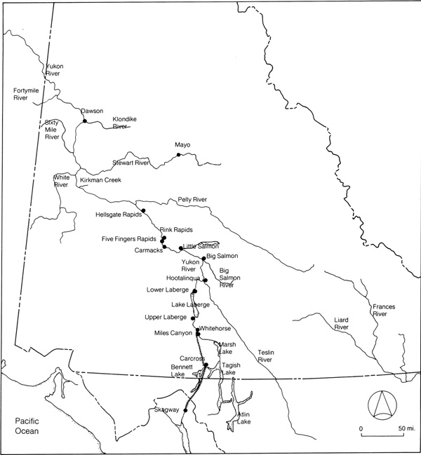
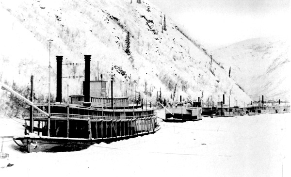
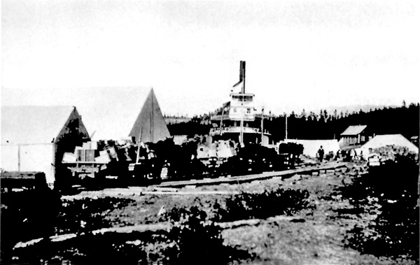
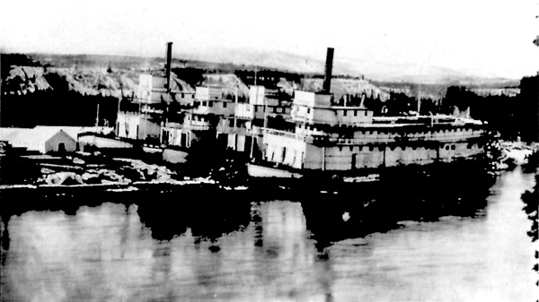
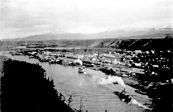

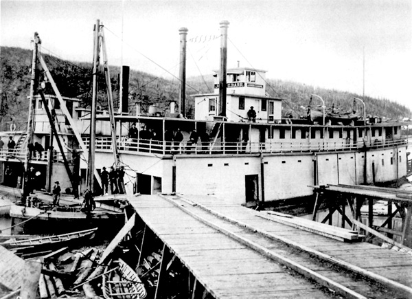
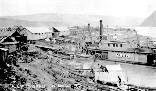
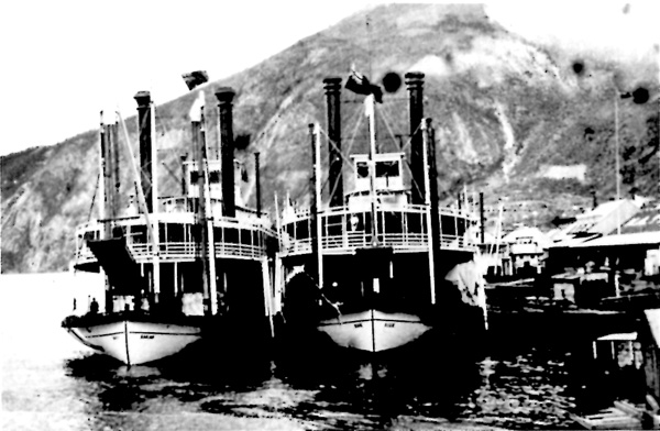
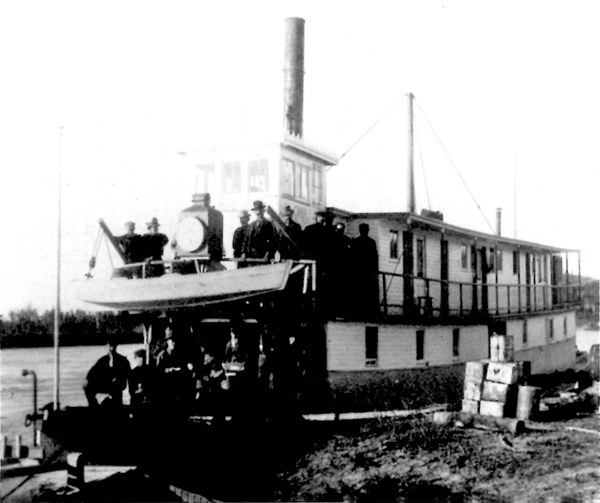
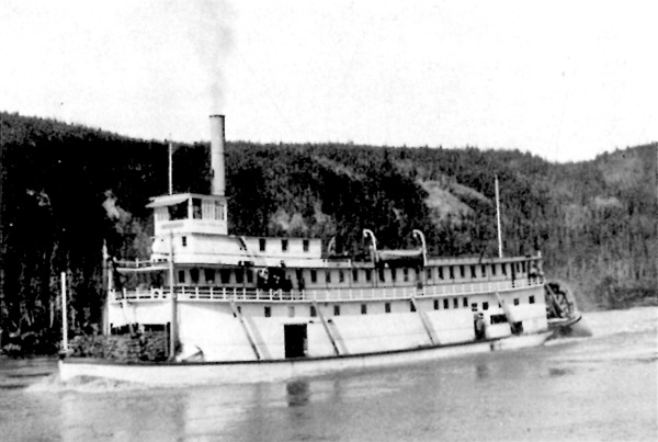
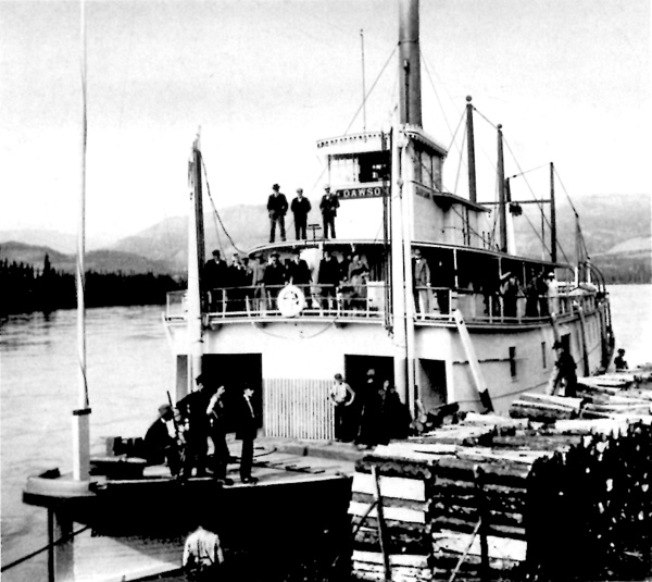

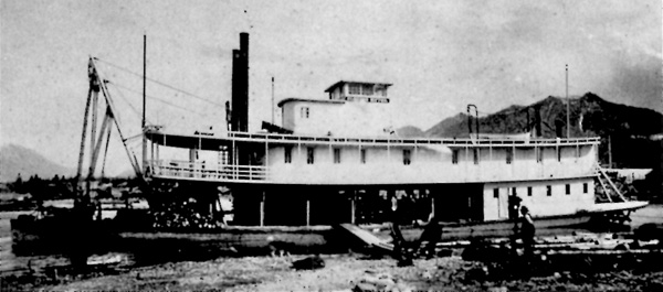

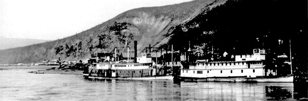
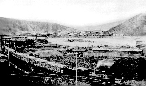
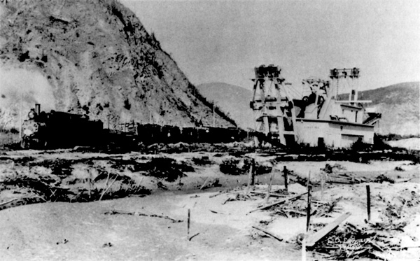

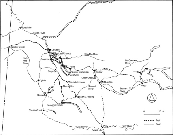
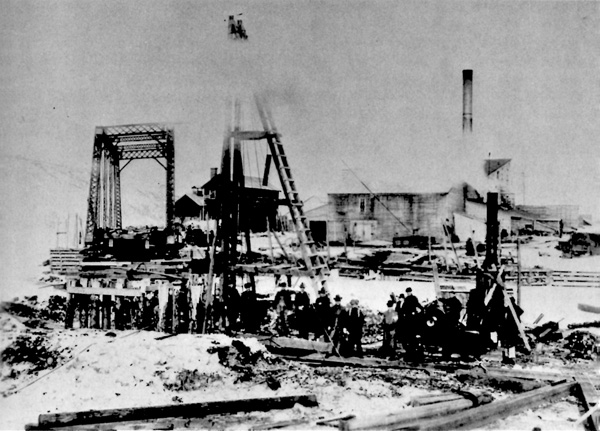
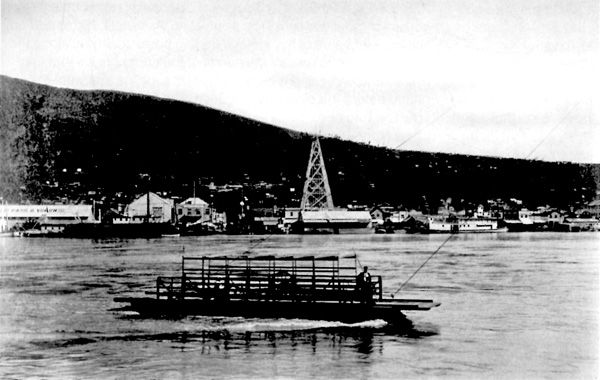

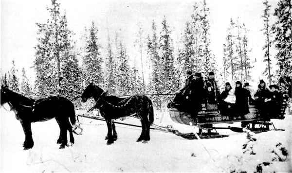
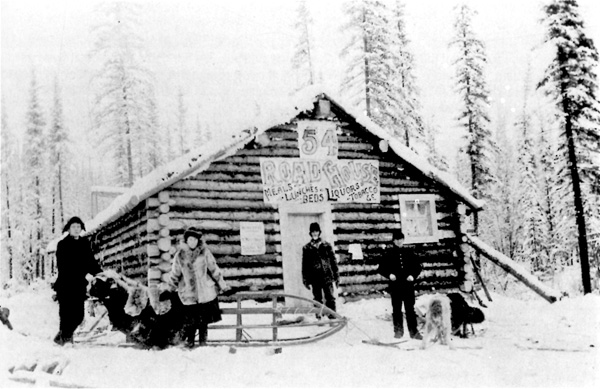
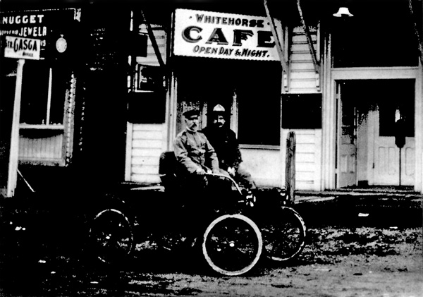

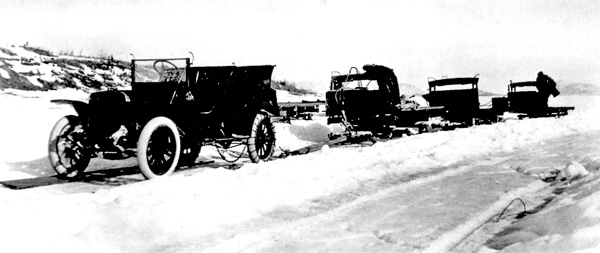
|
||||||||