Canadian Historic Sites: Occasional Papers in Archaeology and History No. 7
Archaeological Explorations at Signal Hill, Newfoundland, 1965-1966
by Edward B. Jelks
Artifact Provenience
Provenience data for the various categories of artifacts are given
in Tables 4 through 11. Differences in the distribution patterns of some
categories are apparent. Some of the differences probably reflect
slightly different dates for certain parts of the site. Others, perhaps,
are a factor of function: one would expect to find different kinds of
artifacts around a men's barracks than around an officers' barracks;
different things around a battery than around a canteen.
The depositional units at Signal Hill, by and large, could not be
dated closely. In some parts of the site such as Lady's Lookout proper
there was no more than an inch or two of soil overlying the bedrock. At
other places, such as the south flat at Lady's Lookout, there was a foot
or so of soil, but it was unstratified. At the lower Queen's Battery and
at shelf A of the east flat at Lady's Lookout, the building foundations
were laid on bedrock or on piles of stone rubble that had been hauled in
and used to level the ground where the buildings were to be built.
Eventually the buildings were razed, leaving only the lower courses of
the stone foundations intact for the archaeologist to find and
study.
The dates of some depositional components were estimated, but except
for the zones of rubble fill, the components had to be dated quite
grossly. Furthermore the dates for the richest artifact-bearing zones,
being estimates, are necessarily somewhat tenuous. But despite these
difficulties, date estimates for the major depositional components have
been made.
Lower Queen's Battery
Zone E: 1796
Zone D: 1796-1840
Zone B & C: 1840-1870
Zone A; 1870-1965
Upper Queen's Battery
Structure 2, room A: 1880-1955
Structure 2, room B
Lower level: 1850-1930
Upper level: 1930-1940
Structure 2, room C
Miscellaneous: 1820-1955
Latrine deposits: 1820-1860
Structure 2, room D: 1890-1955
Structure 2, room E:
Lower level: 1831-1860
Upper level: 1860-1955
Lady's Lookout
Proper: 8,000 B.C.-1965
South flat: 8,000 B.C.-1965
East flat
Zone A, shelf A: 1811
Zone B, shelf A: 1811-1855
Zone C, shelf A: ca. 1855
Zone D, shelf A: 1855-1966
Midden at NE, corner of structure 11: 1811-1860
Latrine & ash-pit deposits (structures 13 & 15): 1820-1860
The only zones that can be dated with any degree of precision are
zone C of shelf A at Lady's Lookout, east flat, and the zones of rubble
fill (zone E at the lower Queen's Battery and zone A at east flat, shelf
A, Lady's Lookout). The rubble zones were virtually sterile save for a
few artifacts that apparently had worked down from the zones above into
the interstices between the stones. The mortar in zone C at the east
flat is believed to have come from the rating of structure 10, which
probably took place about 1855, but the artifacts found in the zone
could hardly all date from the brief interval when structure 10 was
being torn down.
The strata richest in artifacts were zone D at the lower Queen's
Battery zone B at the east flat of Lady's Lookout, the midden at the
northeast corner of structure 11, and the latrines and ash pit at the
east flat and in structure 2. These all fall in the period 1796-1860,
and all overlap one another in the 1820-40 range.
Thus the areas excavated to date at Signal Hill have not produced
good samples of artifacts that can be tightly dated. Consequently the
conservative course with regard to dating the artifacts from their
contexts seems to be appropriate here; that is, the bulk of the
regarded as representative of the period 1800-60. Attempts to date the
artifact samples more closely would surely be risky and might well
produce misleading results. If anyone is interested in pursuing the
matter of artifact distribution further, he will find the necessary raw
data in the tables that follow.
Table 1. Summary of Excavated Structures
|
| Structure | Location |
Nature of Remains | Probable Identification |
|
| 1 | Interpretation
Centre |
Stone foundation | ? |
|
| 2 | Upper Queen's
Battery |
Magazines and bldg. foundations |
Magazines and barracks (early 19th century) |
|
| 3 | Lower Queen's
Battery |
Stone foundation |
Barracks (ca. 1812) |
|
| 4 | Upper Queen's
Battery |
Stone foundation |
? |
|
| 5 | Lower Queen's
Battery |
Paved area |
Working floor? |
|
| 6 | Lower Queen's
Battery |
Paved area |
Working floor? |
|
| 7 | Lower Queen's
Battery |
Paved area |
Working floor? |
|
| 8 | Lady's Lookout
(South Flat) |
Stone foundation |
? |
|
| 9 | Lady's Lookout |
Stone foundation |
Blockhouse (1795) |
|
| 10 | Lady's Lookout
(East Flat) |
Stone and brick |
Canteen (1840s) |
|
| 11 | Lady's Lookout
(East Flat) |
Stone foundation |
Commissariat (1811-183?) |
|
| 12 | Lady's Lookout
(East Flat) |
Stone foundation |
Commissariat (1835-185?) |
|
| 13 | Lady's Lookout
(East Flat) |
Stone foundation |
Latrine (1840s?) |
|
| 14 | Lady's Lookout
(East Flat) |
Stone foundation |
? |
|
| 15 | Lady's Lookout
(East Flat) |
Stone foundation |
Ash Pit |
|
| 16 | Lady's Lookout
(East Flat) |
Stone foundation |
? |
|
Table 2. Summary of Button Data.
(click on image for a PDF version)
Table 3. Summary of Coin Data.
|
| Coin Type | No. of
Specimens |
Reference |
|
| 1799 farthing | 1 | Peck 1960: 347-8 |
|
| 1825 farthing | 1 | Raymond 1953; #35 |
|
| 1826 halfpenny | 2 | Raymond 1953: #37 |
|
| 1900 halfpenny | 1 | Peck 1960: #1956 |
|
| 1797 penny | 2 | Peck 1960: 292 (Type 4) |
|
| 1806 penny | 2 | Peck 1960: 371 |
|
| 1943 penny (Canadian) | 1 | Charlton 1966: 66 |
|
| 1812 penny token | 2 | Charlton 1966: #195 |
|
| 1813 penny token | 1 | Charlton 1966: #198a |
|
| 1823 dime (U.S.) | 1 | Yeoman 1966: 105 |
|
| Unidentified | 1 |
|
|
Table 4. Artifact Tabulation, Lower Queen's Battery Area.
(click on image for a PDF version)
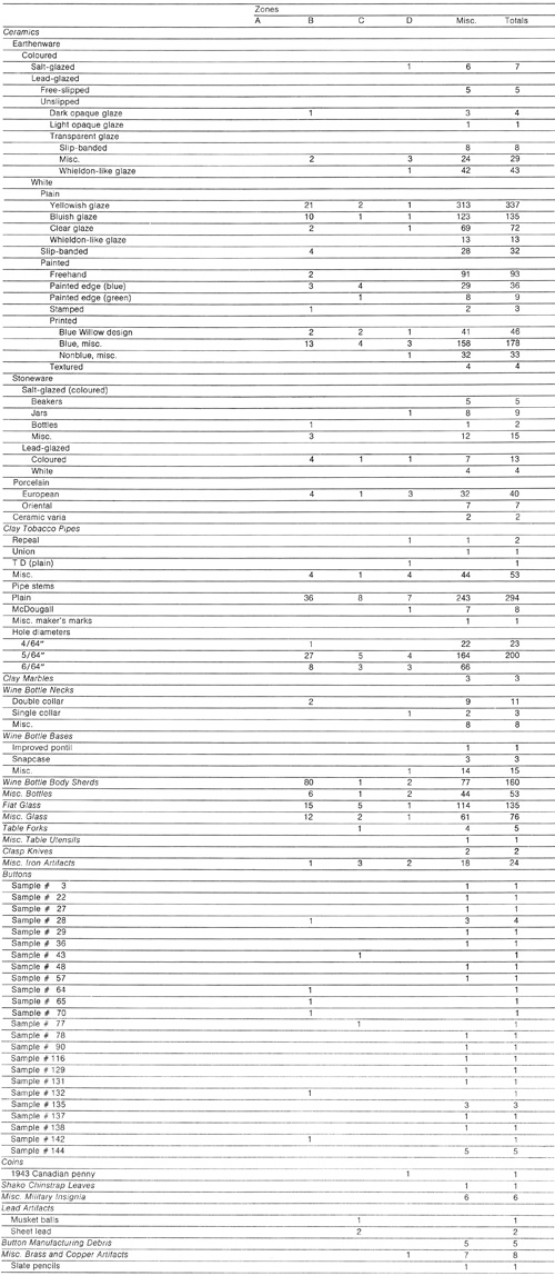
Table 5. Artifact Tabulation, Structure 2, Room C.
(click on image for a PDF version)
Table 6. Artifact Tabulation, Structure 2 (Excluse of Room C).
(click on image for a PDF version)
Table 7. Artifact Tabulation, Structure 4 Area and Various Locations
in the General Queen's Battery Area.
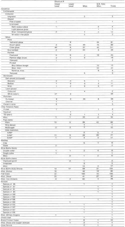
(click on image for a PDF version)
Table 8. Artifact Tabulation, Structure 10 Area.
(click on image for a PDF version)
Table 9. Artifact Tabulation, Structure 11 Area.
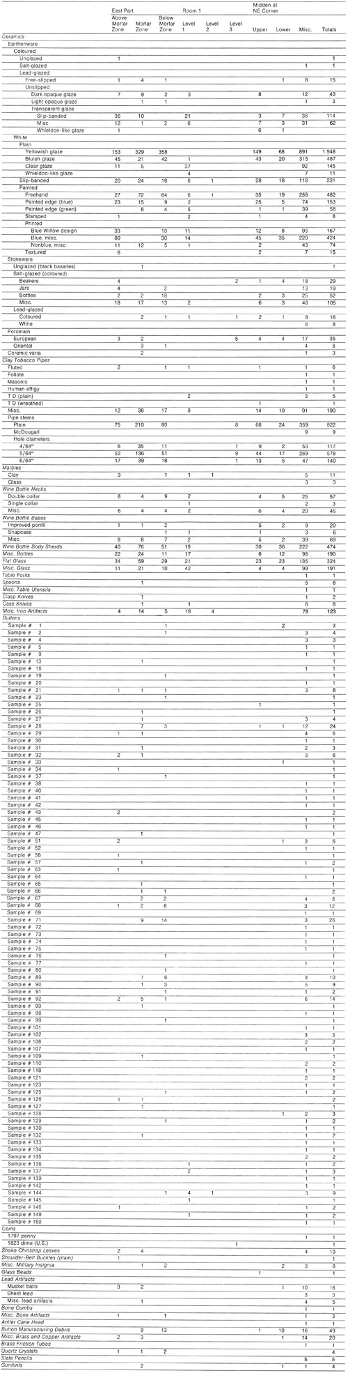
(click on image for a PDF version)
Table 10. Artifact Tabulation, Various Locations in Lady's
Lookout Area, Artifacts with no Provenience Data.
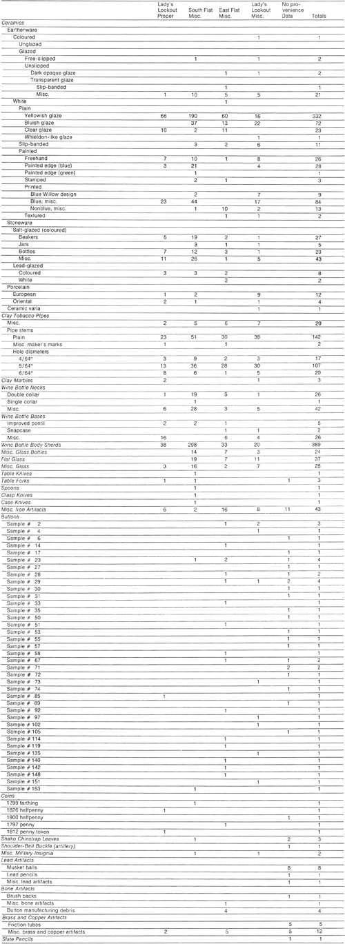
(click on image for a PDF version)
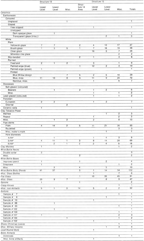
Table 11. Artifact Tabulation, Structures 13, 14 and 15.
(click on image for a PDF version)
|
