 |
|
Canadian Historic Sites: Occasional Papers in Archaeology and History No. 7
by Edward B. Jelks Lady's Lookout AreaLady's Lookout is a high, narrow ridge, oriented in an approximately north-south direction, which stands just north of the Cabot tower parking lot. One of the earliest structures on Signal Hill, a block house surmounted by a signal tower, which gave the hill its name, was erected at Lady's Lookout before 1800 (Ingram 1964: 2). The highest point on Signal Hill lies on Lady's Lookout. Near the end of the 1965 season, exploratory excavations were undertaken at three places in the Lady's Lookout area: (1) on top of the ridge in the vicinity of the blockhouse (a locality referred to here as "Lady's Lookout proper"); (2) on a level shelf termed the "south flat" that occupies the south flank of the ridge, and (3) on a long, narrow, multi-level bench, the "east flat" that runs along the east flank of the ridge. During the 1965 season remains of the block house foundation (structure 9) were unearthed on top of the ridge and traces of an unidentified building (structure 8) were discovered on the south flat. Only one small test was dug at the east flat in 1965. The 1966 season was devoted entirely to excavation of the east flat. It was known from documentary records that a commissary building had occupied the flat from 1811 until the 1830s (Ingram 1964: 41-2); that a two-storey canteen stood there in the 1830s and 1840s (Ingram 1964: 34-5), and that a later commissary building extending southward from the canteen area was in existence from 1835 until the 1850s (Ingram 1964: 34). By the end of the season, remains of all three of those buildings had been identified. Both the canteen (structure 10) and the earlier commissary (structure 11) were completely excavated, while the later commissary (structure 12) was partially exposed. In addition, a latrine (structure 13) was excavated together with its adjoining ash pit (structure 15), and two building foundations (structures 14 and 16) were found of which apparently there is no historical record.
Lady's Lookout Proper Lady's Lookout proper consisted of a comparatively level central area some 80 ft. across bordered on both north and south by a small knob of bedrock. The surface of the central area was comprised of bare bedrock save where depressions had trapped patches of thin soil. This area had been intentionally flattened as was attested by the presence of blasting holes drilled into the bedrock. Beyond the flattened area on the north was a deep cut in the bedrock, 70 ft. long, 40 ft. wide, and 30 ft. deep, where stone had been quarried. On the knob at the south edge of the flattened area was a conspicuous, circular mound of rubble and earth which, upon trenching, proved to be a United States Army anti-aircraft gun installation of World War II. The only in situ structural remains at Lady's Lookout proper were several sections of a building foundation (structure 9) identified with the 1796 blockhouse. Debris scattered about the surface suggested that other buildings had occupied the vicinity in the past, but no in-place structural elements remained and the exact location, size, and architectural details of these hypothetical buildings could not be determined. Stratigraphy The surface at Lady's Lookout proper consisted of bare bedrock relieved here and there by shallow depressions in which a few inches of soil had accumulated. There was too little soil for any stratification: in fact, exposing of the blockhouse foundation was more of a cleaning-off operation than true excavation. A few artifacts were unearthed in the course of excavating around structure 9, but the spottily distributed soil was too thin to contain much in the way of cultural debris. Structure 9 The only surviving remains of structure 9 were several discontinuous remnants of a stone masonry foundation (Figs. 41, 43) which had been afforded scant protection by being located in some of the shallow depressions in the bedrock at Lady's Lookout proper. This structure was surely the blockhouse building 29 of the historical base map (Fig. 4) that was erected about 1796 (Ingram 1964: 27).
Two major sections of wall foundation were still intact, and fortunately they were situated at opposite corners of the square building so its ground level dimensions could be determined accurately. There was a third masonry remnant in the interior of the building which clearly was part of the foundation of interior walls shown on a contemporary plan of the blockhouse (Fig. 42).
The stones were carefully fitted and mortared, and the foundations were quite strong. A good deal of ingenuity had been required to adapt them to the knobs, ridges, and depressions of the bedrock on which they were directly laid. Several tiers of stones were present at both the east and west corners (Fig. 45). Of some interest was a large boulder weighing hundreds of pounds that was incorporated in the northwest wall. Structure 9, as measured in the field, was 30 ft. square (outside dimensions of the foundation), and the walls were 4 ft. thick. These are the exact documented dimensions of the blockhouse (Ingram 1964: 27).
Lady's Lookout: South Flat The shelf on the south slope of the Lady's Lookout eminence, the south flat, was explored thoroughly through a series of trenches. The only significant feature discovered was the incomplete foundation of an unidentified building, structure 8. Stratigraphy Soil completely blanketed the surface of the south flat, but it was shallow (less than 2 ft. thick) and unstratified. It appeared largely to be detritus that had washed down from the higher ground to the north. Although the soil contained a fair quantity of artifacts, they could not be related with certainty to structure 8 nor to any other occupational feature owing to the absence of discrete depositional components. Structure 8 Structure 8 was a wall foundation consisting of two parallel rows of stones a foot apart, each row 1.5 ft. wide and 14 ft. long (Figs. 44, 46). On and among the stones, which resembled thick flagstones, were traces of mortar. This probably was a footing for a wall of a frame building, but if so, neither corners nor footings for the other walls were found in spite of a careful search. Just north of the footing was a mass of stone debris about 15 ft. in diameter that could have been a fallen and scattered chimney.
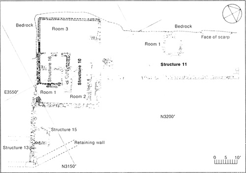
Lady's Lookout: East Flat The east flat consisted of three subareas which will here be referred to respectively as shelves A, B, and C (Figs. 47, 48). Shelf A is an artificially levelled expanse where structures 10, 11, 13, 15, and 16 were situated. Shelf B is a more or less natural bench adjoining shelf A on the south and standing at an elevation some 10 ft. higher than shelf A. Shelf C is a very narrow, artificially levelled area running along the seaward edge of shelf B at approximately the same elevation as shelf A.
Shelves A and C were created by erecting a sturdy retaining wall of massive, squared sandstone blocks along the steep eastern slope of Lady's Lookout ridge and then filling in behind it with stone rubble. Shelf A was further extended to the west and to the south by quarrying the bedrock. Shelf A is about 120 ft. long (north-south) by 40 ft. wide (east-west); its eastern edge, formed by the masonry retaining wall, drops precipitously to Ross' Valley some 300 ft. below, while its western and southern edges are delineated by stone scarps standing at a maximum height of more than 15 ft. A large quantity of detritus, evidently washed down from the higher ground to the west, had accumulated on shelf A after the buildings which formerly stood there had been razed. This material was banked heavily against the vertical scarps at the western and southern edges of the shelf. The detritus had completely buried the building foundations; consequently, prior to excavation, no structural remains were visible on the surface except the retaining wall at the eastern edge of the shelf.
Shelf B appeared to have been a naturally level space with perhaps a few rough spots that were flattened before structure 14—evidently the only building ever built there—was erected. Roughly rectangular in shape, shelf B measured approximately 100 ft. in its north-south dimension and 40 ft. east to west. Shelf C was formed by filling behind a southward extension of the same masonry retaining wall that faced the eastern edge of shelf A. A commissary built in 1835 (structure 12) occupied the entire area of shelf C. The east wall of the commissary, in fact, was laid directly on top of the retaining wall, and its opposite wall stood against a low scarp marking the inland edge of the shelf (Ingram 1964: 35, sketch). Shelf C is about 100 ft. long but only 11 ft. wide. This corresponds closely to the recorded dimensions of the commissary (Ingram 1964: 34; historical base map, Fig. 4). Stratigraphy Shelf A Four major stratigraphic zones of archaeological significance were observed at shelf A (Fig. 52).
Zone A. The stratum of stone rubble fill had been placed behind the heavy retaining wall to level the eastern part of the shelf. The individual stones were jagged pieces of sandstone ranging from fist-sized chunks up to boulders weighing hundreds of pounds. Most or all of them probably came from quarrying the western part of the shelf in the levelling process. Some of the building foundations were built directly on the surface of the zone A rubble (Fig. 63). In most places the interstices between the stones were empty, but several spots were found where earth and trash had worked down into the spaces. Occasionally, too, artifacts were found where they had fallen in between the stones. The thickness of zone A was variable, ranging from a foot or two up to perhaps 10 or 12 ft. Although a few exploratory tests were dug several feet down into zone A, as a general rule the excavations were terminated on reaching its surface. Its maximum depth was not determined. Zone B. A layer of dark brown soil, 1ft. to 3 ft. thick in most places, was distributed over most of shelf A. It rested on top of zone A at spots where zone A was present; elsewhere it lay on the quarried bedrock floor. Zone B was one of the most productive of the artifact-bearing zones. Zone C. A quite distinctive, light grey stratrum was composed almost entirely of crumbled mortar. Varying from 1 in. to 12 in. thick, zone C may have accumulated on the surface of the ground when the canteen was torn down, then have been buried under the mantle of detritus that built up subsequently. As is often done today, the mortar may have been scraped from the salvaged bricks on the spot in order to reduce the task of hauling them away for re-use. If so, everything found stratigraphically below zone C (that is, in zones A and B) should date from a time prior to the razing of the canteen, evidently about 1855; everything above zone C, by the same token, should have been deposited after that date. Zone C extended over the entire structure 10 area except for several places where it had been disrupted by the construction of structure 16 (which post-dated structure 10) or where there were other local disturbances. Zone D. A layer of dark brown soil, averaging about a foot thick, lay next above zone C and extended up to the surface of the ground in most parts of shelf A. Zone D contained not only 19th-century trash but also material dating from World War II and later. Localized Zones. Two localized strata in the shelf A area appeared to be depositionally discrete and therefore were used as contextual association units for artifact distribution studies. The zones were: (1) a layer of midden soil inside room 1 of structure 11, and (2) an accumulation of dark, trash-filled soil heaped around the exterior of the northeastern corner of structure 11. Neither stratum contained substrata; both, however, were excavated by arbitrary vertical increments which were later employed to give the artifact distribution patterns a gross temporal dimension. Shelf B The only excavation of shelf B was for the purpose of discovering the extent of structure 14. The entire top of the structure's foundation was exposed, but the foundation was not followed down to its base except in three or four shovel-wide tests. These indicated that bedrock lay at a depth of 1.5 ft. to 2.5 ft. over most of the shelf B. No significant strata were observed, and it is not likely that any are present. More thorough study of structure 14 and shelf B will be required, however, before an accurate stratigraphic appraisal is possible. Shelf C Exploration of shelf C was inadequate for accurate interpretation of the stratigraphy. Limited testing did reveal that zone A, the basal layer of rubble fill behind the retaining wall at shelf A, extended into the northern part of shelf C where, as a rule, it was buried under an accumulation of soil only a few inches thick. Probably zone A continued along behind the retaining wall all the way across shelf C, but this was not determined with certainty. There are probably only two major strata at shelf C, the thin stratum of superficial soil and the underlying zone A till. Only through future excavation can full and accurate knowledge of the stratigraphy be acquired. Structure 10 Structure 10 consisted of the masonry foundation of a rectangular building together with sections of its west and south walls, made of brick, that still stood several feet high. As may be seen by comparing Figures 47 and 53, these ruins are patently the remains of the canteen that occupied shelf A during the 1840s. The canteen was a two-storey, rectangular building 50 ft. long and approximately 30 ft. wide.
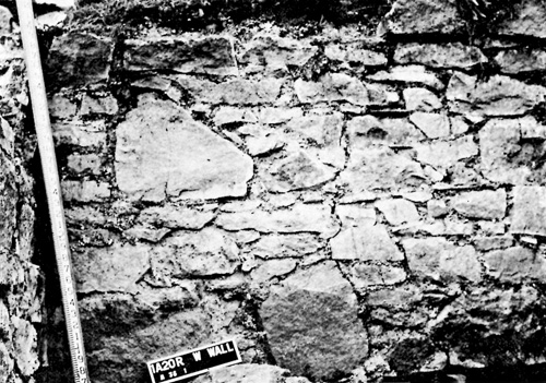
The west and south walls of structure 10 (Figs. 55, 56) were of double construction, consisting of outer and inner components with an air space about 3 in. wide between. Both components were of coursed brick. The entire west wall was built against the face of the vertical bedrock scarp that forms the west edge of shelf A, and, because of its protected position, a large section of the wall was still intact when cleared of overburden in 1966. A section of the south wall where it cornered on the west wall also still stood against the scarp.
The exterior component of the double wall consisted of coursed bricks laid just in front of the scarp face, This component was one brick length wide (approximately 0.75 ft.), and the narrow space between the wall and the scarp was filled with dirt and stone rubble. The lower courses (up to nearly 4 ft. above the base) of the outer component were of a red brick, 0.75 ft. by 0.35 ft. by 0.20 ft. in size, laid in Flemish bond. Above that had survived up to 18 courses of a yellow brick of the same length and breadth as the red brick, but only 0.15 ft. thick. Most of these yellow bricks were broken into irregular lengths, and they were laid in a quite erratic way. They were soft and had eroded extensively in contrast to the red bricks which were well preserved. The inner component of the double wall was formed of overlapping stretcher bricks only, no full-length headers being present. Consequently, this component was only as wide as the bricks (that is, 0.35 ft.). The bricks were yellow but different from the yellow bricks of the outer wall, not only in texture but also in size. They measured 0.75 ft. by 0.35 ft. by 0.25 ft. Along the west wall there were irregularly spaced gaps at the base of the inner component which apparently were intended to drain moisture in conjunction with the between-wall space. Abutting against the base of the west wall on the inside was a series of individual yellow bricks (like those of the inner wall) placed on the bedrock about a foot apart; these evidently were supports for a floor joist. Part of structure 10's south exterior wall had been replaced by the south wall of structure 16 (Figs. 47, 64). The east wall foundation of structure 10 was made of roughly squared blocks of local sandstone (Fig. 57) except for a section made of lime and gravel concrete (Fig. 58). A similar foundation of sandstone blocks supported the eastern part of the north wall where the bedrock dipped deeply; the western part of the north wall rested directly on the bedrock.
Three rooms were marked off in structure 10 by interior partition walls. They were designated rooms 1, 2, and 3 and may readily be correlated respectively with the cellar, bar, and taproom of the canteen as shown on the contemporary plan (Fig. 53). The foundation of a major east-west partition wall dividing rooms 1 and 2 was made of rough sandstone blocks laid on bedrock. It probably supported a wooden wall as it was too narrow to have provided adequate support for a wall of masonry. A second partition-wall foundation, running north-south, was built on bedrock across the western part of structure 10. It separated room 3 (the taproom) from the rest of the lower storey of the canteen. The remains of this partition stood only from 2 in. or 3 in. to a maximum of about 12 in. high. The ends of the partitions abutted against the inside of the exterior walls, but none of the junctures were bonded. Extending northward from the exterior of the north wall of structure 10 was the foundation of a small stoop about 5 ft. wide by 3 ft. long (Fig. 59). The stone base of a step leading up to the stoop was still intact as were two wooden beams on the tread of the step.
Structure 11 Structure 11, clearly the earlier commissary built in 1811 (building 77 of the historical base map, Fig. 4), consisted of a heavy foundation made of crudely shaped, dry-laid sandstone blocks that underlay the east wall of the original building, together with a short section of the north wall foundation where it cornered on the east wall (Figs. 47, 50, 51). No traces of the south or west walls survived. Structure 11 occupied the northern part of shelf A, overlapping a bit with structure 10 which lay just to the south. The north wall of structure 10, in fact, was built over the east wall foundation of structure 11, establishing positively their relative temporal positions. At the south end of the east wall of structure 11 the foundation rested directly on bedrock, but no definite corner was present, the wall simply fading out within structure 10. The central part of the east wall foundation was not followed all the way down to the bottom, but excavation at the north end revealed that the wall stood directly on bedrock there also. A carefully squared stone marked the corner of the east and north walls (Fig. 61), and a section of the north wall foundation extended from the corner for a distance of about 5 ft.
The west wall of structure 11 was evidently built right against the vertical cliff at the edge of shelf A, but no foundation stones survived. The south wall was completely missing, too, probably having been destroyed during the construction of structure 10. There was a small stone foundation about 10 ft. square near the west edge of shelf A, entirely within the confines of structure 11 (Fig. 47, 62). Although designated room 1 of structure 11 in the field notes, there is no way at present to establish its actual relationship to structure 11 as it is entirely isolated from that structure's foundation. It was built directly on bedrock and had a narrow opening, apparently for a doorway, in the middle of its east wall. The foundation was constructed of flattish pieces of local sandstone (many crudely squared) with only a few traces of mortar remaining. The stones varied from about 2 in. to well 60 over a foot in thickness, most being in the 4 in. to 8 in. range. Room 1 most likely was not a part of the commissary but a small building erected after the commissary had been razed.
Adjacent to the scarp in the northwestern part of structure 11 was a rectangular pit that had been excavated into the bedrock. It was 8.2 ft. long by 5.5 ft. wide and was between 5 ft. and 6 ft. deep (below the modern surface). Filled with loose rocks, earth, wooden boards, tin cans, and a variety of trash, this feature is probably a latrine built by the United States Army during World War II. In any event, the presence of modern wire nails, Schlitz beer cans, and other quite recent objects indicates that it is of 20th-century vintage. Structure 12 Structure 12 is the designation given to the archaeological remains of the later commissary building erected in 1835 (building 63, Fig. 4). The east wall of the commissary was built on top of the retaining wall that runs along the east edge of shelf C. It is evident, therefore, that the building, which was about 100 ft. long by 11 ft. wide, occupied virtually the whole extent of shelf C. No trace of the east wall remained, although the retaining wall on which it had stood was still largely intact. In order to determine whether any of the west wall had survived, a few small test trenches were dug just before the close of the 1966 field season. Poorly preserved segments of the west wall were found buried near the south end of shelf C; however, as the southern three-fourths of the shelf was not explored, both the areal extent of the ruins and their significant details of construction must remain unknown until further investigation is made. Structure 13 Structure 13 consisted of the lower masonry walls of a small trapezoidal room, about 9 ft. long by 5 ft. wide, that is unmistakably a latrine shown on the 19th-century plan of the canteen (Fig. 53). The latrine was attached to the north end of the later commissary (structure 12), its east wall being built on top of the heavy retaining wall that faces the eastern side of shelves A and C. Contiguous to the latrine on the west and sharing a common wall with it was an ash pit assigned the archaeological designation structure 15. The south wall of structure 10 projected eastward all the way to the retaining wall and served not only as the south wall of the latrine and the ash pit, but also as the north wall of structure 12 (Fig. 47). The latrine wall that originally stood on the retaining wall was missing, but the other three walls of structure 13 were still in a relatively good state preservation in 1966. Roughly dressed blocks of sandstone were mortared together, with an occasional brick included here and there, to form the uncoursed yet carefully fashioned masonry walls (Fig. 63). The walls stood on a jumble of large stones (part of the rubble placed behind the retaining wall for the purpose of levelling the shelf) which provided an uneven but quite solid foundation for the latrine.
Excavation of the fill inside structure 13 produced a quantity of well-preserved artifacts. Structure 14 Although prior to the archaeological exploration of the east flat there was no historical record of a building on shelf B, an outline clearly visible at the surface indicated that the foundation of a building was buried there. During the 1966 season the top of the entire foundation was cleared of the few inches of soil covering it, but time did not permit cleaning out the interior, excavating to the base of the foundation (except for two or three shovel-wide spot tests), or studying the structural details thoroughly. Designated structure 14, the foundation proved to be approximately 60 ft. long by 15 ft. wide, its long axis running roughly north and south. A small room about 17 ft. long was partitioned off by a cross wall at the north end of the structure. The foundation was made of crudely squared, roughly coursed pieces of local sandstone laid in an irregular manner. At least two or three courses were preserved in most places. The edges of the walls undulated erratically, especially the inside edge of the west wall. Judging from the spot tests, the entire foundation was probably laid directly on bedrock. Further details regarding structure 14 must await future excavation. Structure 15 Structure 15 was an ash pit attached to the west side of the latrine (structure 13). It was 5 ft. square. The wall construction was similar to that of structure 13, consisting of mortared sandstone blocks. The walls stood on the stone rubble (zone A) used to level the shelf. The approximately 4 ft. of fill inside structure 15 consisted of earth intermixed with ash, charcoal, and a number of broken and discarded artifacts including ceramic vessels, glass bottles, and clay pipes. Structure 16 This slight foundation of small, roughly squared, sandstone blocks (Figs. 47, 64) apparently supported a building 15 ft. square, probably of frame construction. In places its south wall foundation stood to a height of more than 2 ft.; but the foundations of the other three walls consisted of merely one or two courses and averaged only about a foot high.
Structure 16 lay entirely within structure 10 and at first was thought to be part of structure 10. In fact, it was not until the area had been completely exposed that structure 16 was recognized as a separate building. After close study, the relationship of the surviving structural elements showed unmistakably that structure 16 post-dated structure 10 (Fig. 65).
No record of the building represented by this foundation has been found on the maps or in the other 19th-century documents relating to Signal Hill. Its similarity to room 1 of structure 11 suggests that they may represent small coeval buildings erected after structures 10 and 11 had been razed—that is, after the 1840s. History of the Lady's Lookout Area The first building in the Lady's Lookout area was a blockhouse that was erected in 1796 at Lady's Lookout proper. On the ridge, just west of the blockhouse, a small officers' barracks and a storeroom were begun the same year. Between 1800 and 1810, officers' and men's barracks were erected in the Lady's Lookout area, along with a number of smaller buildings—guardhouse, forge, cook-house, and the like (Richardson 1962: 6, 9). Between 1810 and 1817, materials were stockpiled and construction was begun on an ambitious plan to make the Lady's Lookout area into a virtually impregnable fort, after which Fort William and the other forts in the town of St. John's were to be abandoned. But peace came in 1815 and the work was promptly suspended. Over the following decades, interest in completing the fortification of Lady's Lookout was periodically revived but was never sustained for long. Consequently when imperial troops were withdrawn from Newfoundland in 1871, the fortifications had never been finished (Richardson 1962: 9-10). On the flanks of the hill below the crest of the ridge, a series of structures were built during the first half of the 19th century. Included were commissaries, barracks, a canteen, and small outbuildings of various kinds. Batteries were also emplaced at several spots in the vicinity (Ingram 1964).
Chronology for Lady's Lookout: South Flat As the soil deposits at the south flat were shallow and unstratified, no close dates can be assigned to the archaeological remains there (including structure 8) on the basis of field evidence. The artifacts from the south flat suggest a date in the 1800-70 range.
It is impossible to date the thin soils of shelves B and C with any precision on the basis of present evidence; and even if further excavation were undertaken in those areas it is doubtful that discrete structural components would be found that could be reliably dated within narrow limits. |
|||||||||||||||||||||||||||||||||||||||||||||||||||||||||||||||||||||||||||||||||||||


|
||||||||