|
|
 |
Canadian Historic Sites: Occasional Papers in Archaeology and History No. 1
Archaeological Investigations of the National Historic Sites Service, 1962-1966
by John H. Rick
Excavations in Manitoba
Lower Fort Garry
In 1965, the University of Manitoba accepted a
two-year contract to carry out excavations at Lower Fort Garry National
Historic Park near Selkirk under the general supervision of William J.
Mayer-Oakes. The University employed James V. Chism to direct the
project; he was assisted by Peter Priess and William H. Morgan during
the first excavation season and by Priess and Virginia Gerelus during
the second season.
The stone fort was built in 1831 by George Simpson,
Governor of the Hudson's Bay Company's Northern Department. Simpson
intended this new post to replace the flood-damaged, original Fort Garry
located some twenty miles away at the forks of the Red and the
Assiniboine rivers. The new site was in a better location from the
standpoint of flood control and Simpson hoped to make it a centre for
agricultural development and a shipping depot for the export of tallow,
wool, flax and hemp. However, the Forks was the point where the
agricultural economy along the Red River converged with the fur trade of
the west and Simpson's new post was too far off the beaten track to
stand by itself. In 1835, the original fort (Upper Fort Garry) was
rebuilt on higher ground to combat the floods and from then on Lower
Fort Garry functioned mainly as a supplementary post. It ceased
operations as a trading post in 1911 (Miquelon 1964).
In a field north of the fort enclosure, two 30 ft. x
60 ft. barns were excavated. One of these, presumably the horse stables,
had been a two-storey building with an elaborate two-layered rubble and
cut-stone floor. The second building, an ox stable, had walls of rubble
and mortar fill between closely set vertical logs resting on a stone
foundation. South of the fort, excavations uncovered two superimposed
blacksmith shops utilizing the same stone forge. Partially excavated
was a malt house which had later become part of a sawmill-grist mill
complex; construction appears to be of the same rubble-filled post style
as was found in the ox stable. The miller's house, a small log
structure, was excavated, as was a lime kiln built into a ravine bank. Sections of
the gravelled roadway have been traced throughout the site. A number of
midden areas have been tested and unsuccessful searches were made for
the boatyard and the stableman's residence. Within the fort walls, a
storehouse was excavated and the prison pickets exposed; this latter
feature dates from 1870 when part of Lower Fort Garry was used as a
provincial penitentiary. A troop canteen from the same period was also
dug. A number of minor excavations were carried out around the Factor's
Residence to provide architectural information for the current
restoration of this structure. Various test
trenches were dug throughout the site to salvage archaeological
information prior to the construction of park buildings, water lines,
etc. (Chism 1965; Chism et al. 1967).

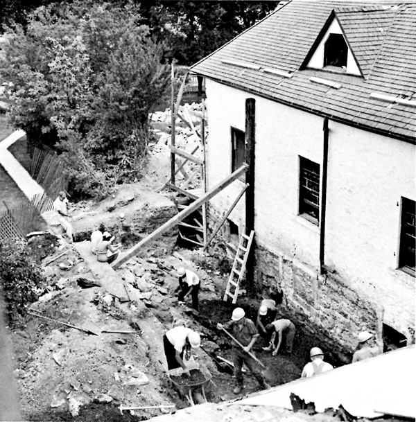
14 Salvage excavations around the Factor's Residence
at Lower Fort Garry. For purposes of stabilization, the foundations of
the "Big House" had to be exposed and archaeologists from the
University of Manitoba. excavating in another part of the fort, were
called in to record information that would otherwise have been
destroyed. This typifies the many minor archaeological problems which
arise in the management of a nation-wide system of historic sites.
(James V. Chism.)
|
|

