|
|
 |
Canadian Historic Sites: Occasional Papers in Archaeology and History No. 1
Archaeological Investigations of the National Historic Sites Service, 1962-1966
by John H. Rick
Excavations in Quebec
The Old Jesuit House
In September of 1962, the author began excavations at
the "Old Jesuit House" in the Quebec City suburb of Sillery. This house
stands on the site of a Jesuit mission built in 1637 and destroyed by
fire twenty years later. Representations had been made to the Historic
Sites and Monuments Board of Canada to declare the house a site of
national importance, primarily because of its supposed association with
important historical figures during the 1637-57 period. Documentary and
architectural evidence proved inconclusive, and archaeological
investigations were carried out in an effort to determine the relationship
of the present structure to the original mission.
The cellar of the Jesuit House is divided roughly in
two by a transverse wall; the east half is a single open space, while
the west portion is filled with earth to the height of the ground floor
joists. This situation presented two obvious possibilities, the first
being that the exterior walls of the present cellar were built as a unit
with the transverse wall as a later addition. Alternatively, the
earth-filled half could represent the foundations of a smaller, earlier
structure of which the east wall was the present transverse wall; this
would mean that the east half of the existing cellar represents a later
period of construction. Since the transverse wall had been cut away at
either end, it was not possible to establish its relationship with the
north and south exterior walls; however, trenches excavated outside the
house against the north wall indicated that the foundations of the Old
Jesuit House represent a single piece of construction.
The Old Jesuit House is situated at the bottom of a
steep bluff where runoff is sufficient, even under normal weather conditions,
to cover the cellar floor with several inches of water and to
flood the low spots in the back yard. Made worse by an unusually wet
summer, these water conditions forced suspension of the excavations. The
Engineering and Architectural Division of the National and Historic
Parks Branch was called in to construct a drainage system
which would permit digging the next summer.
The drains, installed in the autumn of
1962, reduced the flow of ground water to a
manageable level. More important, the trenches for these drains revealed
the stub of a three-foot thick stone wall to the north of the present
house. The author and his assistant, Ian C. Rodger, returned to the site
in August of 1963. Excavations showed this wall to be the remains of the
north curtain of the mission fortifications. The northwest bastion
— a round, stone tower — was also uncovered, as was part of the west
curtain. One small portion of the east curtain was found. The south wall
and its two bastions appear to be under a railway embankment and the
northeast bastion seems to have been destroyed in the building of a
neighbouring house. These excavations established that the present
house is located on the mission site, but did nothing to prove or
disprove its antiquity.
Early in 1964. the owners of the house removed the
flooring above the west half of the cellar, thereby affording an
opportunity to dig in this area. Rodger began excavations in March; he
discovered the remains of a stone wall forming part of two sides of an
earlier structure which had been cut through to build the foundations of
the existing house. On this evidence, the Old Jesuit House must
post-date the main period of mission activity.
The final excavations were carried out by Rodger and
the author during the latter part of May, 1964. While several small
walls were uncovered in front of the Old Jesuit House, these could not
be traced without tearing up the heavily travelled street which bisects
the site. A stone wall was discovered extending at right angles east
from the west curtain, but a large tree had obliterated the crucial
junction; this new wall was followed until it ran under a modern annex
to the Old Jesuit House. A brief excavation carried out beside the
chapel revealed several poorly preserved skeletons of children. The
chapel itself had been thoroughly excavated in the late 19th century and
additional work in this area seemed pointless.
Except for one or two strata immediately above
bedrock, there is little undisturbed ground at the site. Constant
activity for three centuries (including construction of a paved street
through the middle of the site) has made it virtually impossible to
trace stratigraphy from structures of known date (such as the chapel and
the fortifications) across the site to the present house. Artifacts
were abundant, but occurred almost entirely in the upper, disturbed
levels; nothing was found that could be stratigraphically associated
with known early walls. The study of this material is not yet complete,
but so far nothing of indisputably 17th-century origin has been identified.
There is, however, no evidence to suggest that buildings existed
on the site prior to the 1637 construction. Therefore, whether the
earliest structures found date from 1637 or from after the fire of 1657,
the present Old Jesuit House must be regarded as later still.
Cartier's Wintering Place
The author's final investigation of the 1962 season
took place at the junction of the Lairet and St. Charles rivers in
Quebec City. The purpose of the work was to locate, if possible, the
remains of a fort built by Jacques Cartier during the winter of 1535-36,
supposedly at this confluence.
Prior to this, in 1959, the National Historic Sites
Service had employed Kenneth E. Kidd to search for the fort. Kidd's
excavations were carried out on a strip of vacant land known as the
Townend property, located on the north bank of the St. Charles River
immediately west of the Lairet. Some of the remains uncovered may be
part of the 17th-century Jesuit seigneury of Notre Dame des Anges, but
no trace of Cartier's settlement was found. Kidd (1959) concluded that
further search for 16th-century remains at that spot would prove
fruitless.
Since nothing had been found on the west side of the
Lairet, it was decided to undertake exploratory excavation on the east
bank. The 1962 work (Rick 1963) took place on a small area of unbuilt-on
land consisting of Cartier-Brebeuf Park and an
adjoining lot to the west. Each of the thirty five
pits dug showed the same stratigraphic sequence, and the pits were so
spaced over the park that there can be no doubt that the excavated area
is typical of the entire site.
The uppermost stratum in each pit was a foot-thick
layer of sandy clay. Artifacts were abundant, but most were obviously
20th century and none appeared to predate the late 19th century. Below
the first stratum was a layer of sand followed by a layer of sandy clay;
both were water deposited and undisturbed by human activity. One pit was
excavated to a depth of 6.2 ft. below surface and a number of others
were dug to depths of four or five feet, but no new strata
were encountered. No traces of posts were encountered in any of the
strata and no artifacts came from below the first level.
It is hardly surprising that no sign of Cartier's
fort was found; even if one accepts as fact the belief that he wintered
near the junction of the St. Charles and the Lairet, there is absolutely
no proof that he built his fort in either of the areas dug. But, had he
done so, there could have been only a slight chance that much would have
survived in an area that has been the centre of so much human activity
for so many years. What is astonishing is that no evidence was found
of the shipbuilding and other industries known to
have been carried out at this site in more recent times. All traces of
pre-20th century activity on the park site have been obliterated.

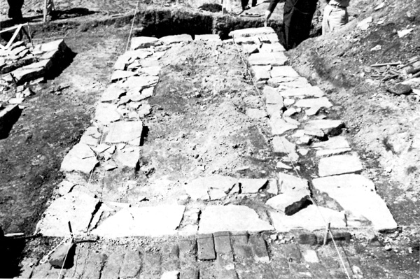
10 Structure 1, uncovered during the 1959
excavations at Cartier-Brebeuf Park, is a well-built foundation wall
measuring 17 ft. x 7 ft. and may be the remains of one of the structures
associated with the 17th century Jesuit seigneury of Notre Dame des
Anges. It bears a striking resemblance to masonry found at Ste. Marie I,
a Jesuit site of the same period, both in terms of stone-working
techniques and the use of timber as a sill on which to build the masonry
superstructure. This use of timber sills was also noted in excavation of
the Number 2 Powder Magazine, a 1708 French building at Fort Anne
National Historic Park, described in this paper.
(Kenneth E. Kidd.)
|
Montreal City Walls
In 1963, the author briefly excavated in Montreal in
response to a request from the City Planning Department for archaeological
assistance. In the course of demolishing two buildings, workmen
had uncovered walls thought to be those of the 18th century
fortifications of the city. One of the walls, paralleling West
Commissioner's Street at the corner of rue St-Sulpice, is somewhat
less thick than documents show the city wall to have been. This wall
formed one side of the basement of the demolished structure, but had
obviously been built at an earlier date and subsequently incorporated
into the building. However, construction of, and subsequent additions
to, the building had completely destroyed archaeological evidence on one
side of the wall, while the other side could not be examined because it
underlay the street.
Whether or not this represents the city's
fortifications might be determined by documentary research;
archaeologically there is no evidence one way or the other. Two other
walls, at the corner of Ruelle des Fortifications and St-Gabriel, were
found to postdate the construction of the Hôtel de France and, since
this had been built about 1818, the walls cannot be part of the city's
fortifications.
Villa de la Broquerie
In 1962. Louis A.
Chevrette and Christopher J. Turnbull carried out a resistivity survey
and brief excavations at the Villa de la Broquerie in Boucherville. This
house, also known as Sabrevois Manor, was reputed to have been built by
Pierre Boucher in 1668, but subsequent architectural analysis and
historical research (Lee 1965a) seem to date the oldest part of the
building to about 1735. However, proponents of the antiquity of the
house claimed that the latter interpretation was erroneous and asserted
that the ruins of a chapel associated with the 1668 construction could
be found to the northwest of the present building. The resistivity
survey confirmed the existence of masonry remains, but excavations
established that these were an integral part of the present house
foundations, not a separate chapel as had been supposed. The
archaeological evidence, therefore, bolsters the conclusions of the
historians that the Villa de la Broquerie is not associated with the
house, chapel and redoubt built by Pierre Boucher in 1668 (Chevrette
1965).
Fort Lennox
Ile-aux-Noix is a low-lying, 210-acre island in the
Richelieu River about ten miles north of the U.S. border. Although
Champlain is reputed to have visited the island in 1609, the first
recorded settlement was not before 1753. In 1759, the French, having
been forced to abandon their Lake Champlain posts, entrenched themselves
at Ile-aux-Noix and threw stockades across the river channels to close
the passage to the advancing British troops. These fortifications
delayed the British attack until August of 1760 when reinforcements
arrived. Surrounded on three sides, the French commander embarked the
greater part of his forces in canoes and escaped with them to Saint-Jean
and Montreal under cover of darkness. The capture of the island was the
prelude to the fall of Montreal and the loss of New France.
Subsequently, the island was briefly garrisoned by
British troops and, in 1775, was captured and used as a temporary base
by invading American forces. The loss of, and the need for defence
against, the American colonies emphasized the importance of Ile-aux-Noix
in guarding the potential invasion route afforded by the Richelieu
River; 1780 marked the beginning of the construction of major
fortifications on the island. During the War of 1812, the island became
a naval station where small warships were constructed.
The years following this war marked another period of
major construction as new fortifications were erected on the south end
of the island; the present earthworks and surviving buildings date from
this period and the site appears to have been named Fort Lennox about
this time. After British troops were withdrawn in 1870, the site was
used as a prison and subsequently abandoned until it became a national
historic park in 1921 (Lee 1965c).

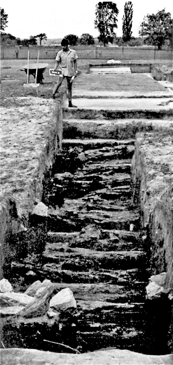
11 Excavations on the glacis, Fort Lennox, 1966
season. The exposed logs are pickets from a British redoubt of the
1780s. When this structure was demolished to make way for the present
Fort Lennox, the palisades were cut down and thrown into the ditch
around the redoubt. This ditch appears to have been part of an earlier
French fortification incorporated into the British works.
(Roger T. Grange, Jr.)
|
The first season of archaeological investigations was
carried out in 1964 under the direction of Norman F. Barka, assisted by
M. Joseph Becker and Ian C. Rodger. Major emphasis was on structures
built after the War of 1812; a large hospital and its associated
cookhouse and a gun shed were among the buildings excavated. A bakehouse
built in 1823 was partially dug and this work was subsequently completed
the following season. Extensive excavation was carried out in the area
of an 1823 ordnance shed and a large men's barracks which had been built
in 1780 and demolished before 1829; no definite trace of the former was
found and the latter survived only in the form of two large hearths and
some soil stains which may indicate the former position of wooden walls.
The search for a lime kiln and a well proved fruitless. Traces of the
first British fort were found under the glacis of the present Fort
Lennox, but much of these early works must have been obliterated during
construction of the existing moat. The considerable amount of overburden
in this area slowed down excavation, and major work on the British fort
had to be deferred until the following year. Attempts to find the French
fortifications were unsuccessful.
Michael J. Ashworth and Ian C. Rodger were
co-directors of the 1965 excavations, with Louis A. Chevrette and Judith
L. Palaski as assistants. Much of the work was centered on buildings of
the 1812-70 period and among the structures excavated were the marine
barracks, a commissariat, two shipwrights' huts, a stable, a cookhouse
and a civilian hospital which had been converted (in 1829) for use as a
chapel. Excavation of the bakery, which had been partially dug in 1964,
was completed. An earthwork, popularly believed to have been a dry dock,
was tested; it seems improbable that this construction could have served
its reputed function, a more likely possibility being that it represents
the start of a projected, but never completed, new system of
fortifications around the island.
Work continued on the first British fort, part of
which had been discovered in 1964 under the present glacis of Fort
Lennox. The main part of the excavation in this area was concentrated on
a structure tentatively identified as the mess house, in the cellar of
which was found a cache of regimental porcelain and glassware. A British
redoubt built about the same period (i.e., 1780-83) was partially
excavated. It had been constructed with a double row of masonry for the
outer walls, behind which were casemates of log construction. In the
interior of the redoubt was found a well-constructed drainage system
probably servicing structures built after 1819. The redoubt itself had
been demolished to make way for the naval yard (Ashworth 1966b).
No trace of French remains were found. The
excavations yielded a large quantity of artifacts of various kinds, a
number of them very closely dated stratigraphically.
The final work at Fort Lennox was a two-month season
in 1966 directed by Roger T. Grange, Jr., assisted by Marcel Plouffe and
John A. Senulis. About a quarter of the 1780s British redoubt and its
associated blockhouse had been excavated the previous year; this work
was completed by Grange. Work also continued on the first British fort
which had been discovered beneath the glacis of the present fort in 1965
and which had been more extensively excavated the following year. The
1966 program uncovered many more structural features of these
fortifications including remnants of palisading and pickets in
situ. When this fort had been levelled to make way for Fort Lennox,
the palisade posts had apparently been chopped off and thrown into the
original ditch to fill it and many of these timbers have been found,
mostly in a good state of preservation. Definite French remains were
uncovered in this area and it was established that the first British
fort had incorporated portions of the earlier French works.
A mound on the east side of the island was excavated
to determine whether or not it was a French blockhouse located in that
general part of the Island. The structure uncovered proved to be a
rectangular building of timber construction. The large quantify of
bottles and the good quality of the earthenware found suggests that this
may have been a private residence or a recreational facility of the late
18th or early 19th century. The structure was completely excavated, but
a detailed analysis of the artifacts recovered will be necessary before
its date and function can be determined with certainty.
On the west side of the island, a rectilinear pattern
of surface depressions was investigated to ascertain whether or not this
might be the location of the French redoubt, St. Antoine. Upon
excavation, the feature proved to consist of drainage ditches and the
foundation posts of a small temporary residential structure. American
and English coins dating from about 1787 were recovered from this
area.
A number of other excavations were carried out in
areas where the meagre documentation suggested French structures might
have been located. Various architectural features were found, but only
extensive analysis will show whether or not these can be dated to the
French period. At present, only the work in the area of the first
British fort can be said to have definitely revealed traces of the
French occupation.
Coteau du Lac
The passage of the St. Lawrence River between Lake
Ontario and Montreal is interrupted by three major rapids which exerted
a most important influence on transport and communication between Upper
and Lower Canada. Of these three, the rapids at Coteau du Lac, near the
present city of Valleyfield, were the narrowest and swiftest, and all
water traffic was confined to a difficult passage suitable only for
small boats, or to a time-consuming overland portage. Towards the end
of the 18th century, the economic and political need to foster the
development of Upper Canada coincided with the military necessity of
supplying the western military outposts against attack from the former
British colonies to the south. As a result, Lieutenant William Twiss of
the Royal Engineers was commanded to build a fortified canal by passing
the rapids at Coteau du Lac. Work began during the summer of 1779 and,
by the autumn of the next year, Twiss had completed a canal with locks,
a storehouse and two small blockhouses. Subsequent work included the
construction of barracks and stables plus a prisoner-of-war compound on
a nearby island. The War of 1812 brought about construction of a
substantial fort, the widening and deepening of the canal and the
replacement of the lock gates. Except for a brief flurry of activity
during the Rebellion of 1837, the post was allowed to gradually decay
and, in 1851, the military establishment was abolished. The commercial
importance of the canal had also declined following the construction of
the Beauharnois Canal in 1842-45 and the increased use of larger steam
vessels on the St. Lawrence.

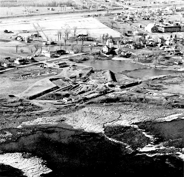
12 Aerial view of the fortifications surrounding
the canal at Coteau du Lac. At the left end of the canal may be seen
the foundations of one of the early blockhouses built to defend it
against American attack. In the right foreground, the unusual
cloverleaf bastion juts out onto the rock flats that were once river
bottom. The low water level is due to modern dams, but the photograph
shows a surviving portion of the rapids which the canal was intended to
bypass.
|
During the summer of 1965, William J. Folan, assisted
by Henry E. Sauerbrunn, directed a three-month excavation program at
Coteau du Lac. This was followed, in 1966, by two months of excavation
again under the direction of Folan, this time assisted by Roger Marois.
These two seasons of work resulted in the complete excavation of the
canal and every major building on the site. Some of these buildings,
such as the hospital and the combination hospital-master carpenter's
shop were built early in the site's history, possibly during the
Revolutionary War, and were substantially repaired and converted to new
uses during the War of 1812; the hospital, for example, having
originally been a storehouse. Many of these older structures were
allowed to fall into ruin in the years after the latter war. A good deal
of new construction was initiated during the war years and immediately
thereafter; much of this gradually decayed, but some structures survived
to be sold and moved off the site in 1872. This sale and subsequent
removal undoubtedly accounts for the absence of substantial
architectural remains in a number of cases where such remains might
reasonably have been expected.
The two blockhouses constructed in 1780 at the ends
of the canal were excavated as was an unusual octagonal blockhouse
designed to hold 200 men; it was built in 1814 and burned in 1837. Other
excavated structures include a barracks for 288 men, a powder magazine,
a guard house, several warehouses, a church, a bakery, a canteen and
various residences such as the commandant's quarters. The
prisoner-of-war encampment on nearby Arthur Island was examined, but
time and money did not permit extensive excavation of this area.
When Folan departed in June, 1966, in order to direct
excavations in British Columbia, his assistant, Roger Marois, remained
to excavate a number of gun platforms and to complete the tracing of
the system of cobbled roadways which link the various buildings of the
post. Marois also excavated two Indian burials, tentatively identified
as late Laurentian Archaic, found beneath the post's clover-leaf bastion.
Thousands of artifacts, including a set of lock gates from the canal,
have been recovered during the two seasons of excavation. The virtual
absence of significant vertical stratigraphy at this site makes it
unlikely that these pieces can be dated by stratigraphic means much more
closely than the 70-year span of the site. Nevertheless, excellent
documentary sources provide a knowledge of the function of each building
excavated and should make it possible to relate the artifacts to less
tangible cultural manifestations such as social class, use and
function.

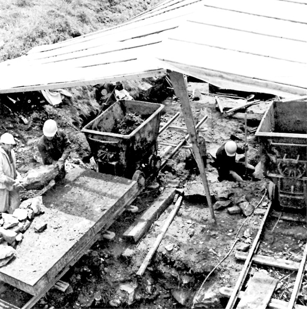
13 An early stage in the excavation of the canal
at Coteau du Lac. Much of the reusable stone in the canal walls and the
fort buildings was removed for civilian construction following the
abandonment of the site. With most of the retaining walls gone, the
canal became choked with tons of rock and earth and a mine railway
proved to be the only feasible method of removing this. The railway was
subsequently employed at Fort Beausejour where the confined space within
the walls prevented the use of trucks. Shown in the photograph are the
dump cars used to transport earth and one of the flat-bed cars employed
in hauling rock.
(Walter Zacharchuk.)
|
|

