|
Geology of Canada's National Parks |
|
|
Geology of Canada's National Parks
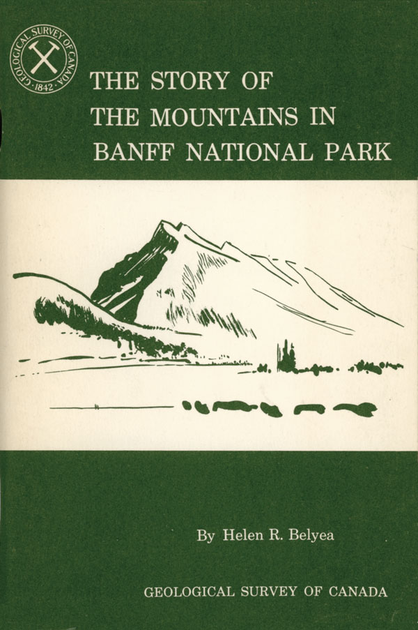
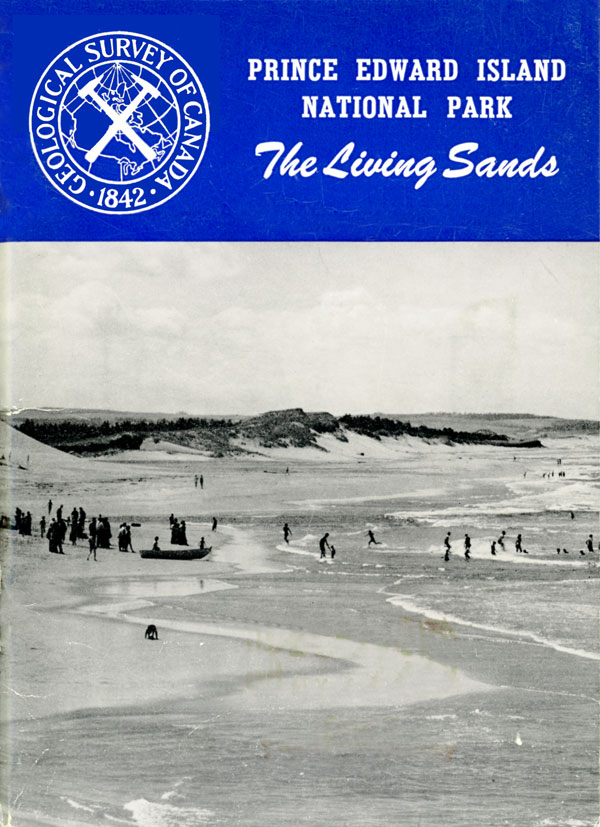
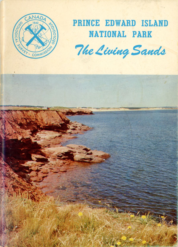
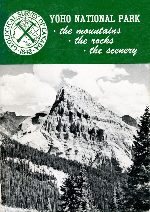
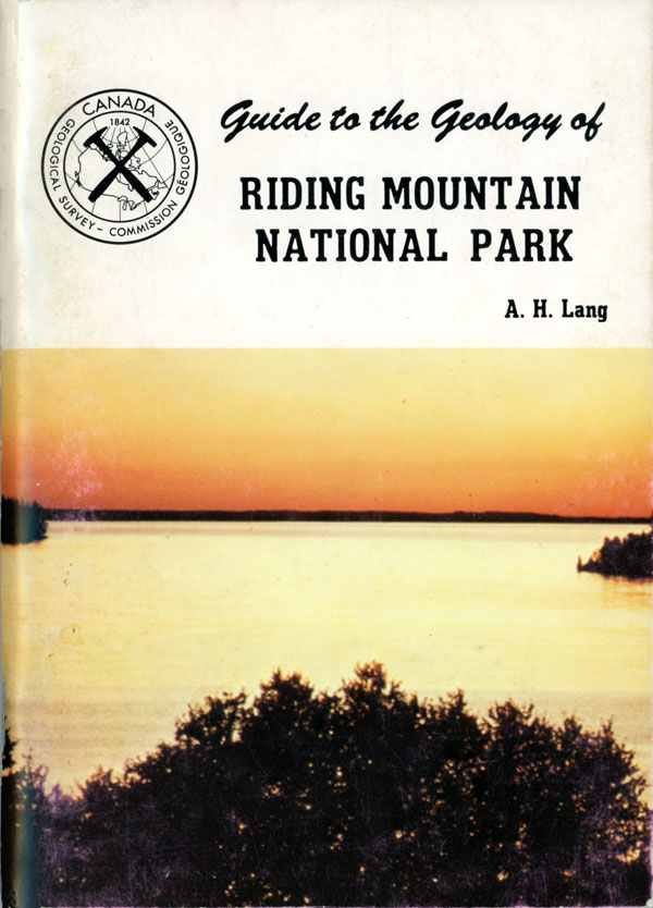
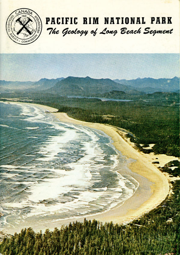
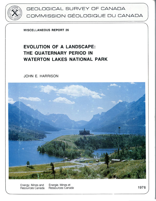
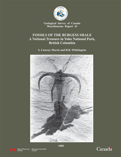
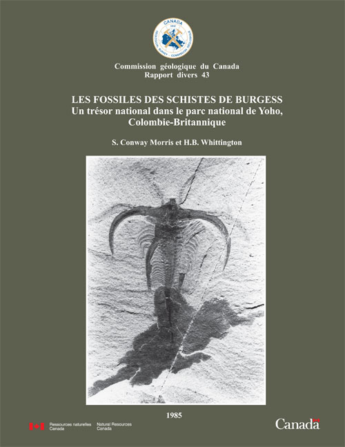
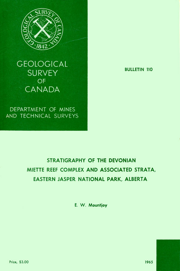
Van Everdingen, R.O., 1964. Report on investigation of Radium Hot Springs, Kootenay National Park, British Columbia, Geological Survey of Canada, Topical Report 97, 1964, 9 p. Gibson, D.W., 1964. Triassic Rocks near the northern Boundary of Jasper National Park, Summary of Activities: Field, 1963, Geological Survey of Canada, Paper no. 64-1, 1964, 2 p. Belyea, H.R. and D.J. McLaren, 1964. Devonian Correlations near Sunwapta Pass, Banff National Park, Alberta Summary of Activities: Office and Laboratory, 1963, Geological Survey of Canada, Paper no. 64-2, 1964, 2 p. Mountjoy, E.W., 1964. Stratigraphy of the Devonian Miette Reef Complex and Associated Strata, eastern Jasper National Park, Alberta, Summary of Activities: Office and Laboratory, 1963, (zip format) Geological Survey of Canada, Paper no. 64-2, 1964, 3 p. Gibson, D.W., 1963. Triassic Rocks near the northern Boundary of Jasper National Park, Summary of Research: Field, 1962, Geological Survey of Canada, Paper no. 63-1, 1963, 33 p. McLaren, D.J., 1963. Alexo Equivalents in Sunwapta Pass Area, Banff National Park, Summary of Research: Field, 1962, Geological Survey of Canada, Paper no. 63-1, 1963, 34 p. Mackenzie, W.S. and E.W. Mountjoy, 1972. Stratigraphy of the southern part of the Devonian ancient wall carbonate complex, Jasper National Park, Alberta, (zip format) Geological Survey of Canada, Paper 72-20, 1972. Potter, D.P. and T. Goodwin, 2013. A teachers guide to the geology of York Redoubt National Historic Site of Canada Geological Survey of Canada, Open File 6964, 2013. 31 p. Sladen, W.E., L.D. Dyke, S.L. Smith, 2009. Permafrost at York Factory National Historic Site of Canada, Manitoba, Canada Geological Survey of Canada, Current Research No. 2009-4, 2009, 13 p. Medioli, B.E. and M.N. Demuth, 2009. Sub-bottom profiling results from Peyto Lake, Banff National Park, Alberta (zip format) Geological Survey of Canada, Open File 5728, 2009, 16 p. Medioli, B.E. and M.N. Demuth, 2009. Reconnaissance sub-bottom profiling studies of Peyto Lake, Banff National Park Geological Survey of Canada, Open File 5727, 2009, 1 p. Zhang, Y., J. Li, X. Wang, W. Chen, W. Sladen, L. Dyke, and L. Dredge, 2012. Assessing the impacts of climate change on permafrost based on field observations and modelling/mapping — Wapusk National Park case study (from Climate Change Geoscience Program: 2006-2011 program final report, Geological Survey of Canada, Open File 6879, 2012) Dyke, L. and W. Sladen, 2012. Assessing the impact of climate change on permafrost based on field observations and modelling - Wapusk National Park case study: sub-activity: in-situ monitoring of permafrost dynamics in response to climate change (from Climate Change Geoscience Program: 2006-2011 program final report, Geological Survey of Canada, Open File 6879, 2012) X. Wang, Y. Zhang, R. Fraser and W. Chen, 2011. Evaluating the major controls on permafrost distribution in Ivvavik National Park based on process-based modelling, (zip format) Geological Survey of Canada, Scientific Presentation no. 9, 2011, 17 p. R.B. Taylor, D. Frobel, A.O. Brown, R. Duggan and L. Reeves, 2011. Field guide for monitoring shoreline change, fortress of Louisbourg National Historical Site, Nova Scotia Geological Survey of Canada, Open File 6966, 2011, 140 p. X. Wang, Y. Zhang, R. Fraser and W. Chen, 2010. Evaluating the major controls on permafrost distribution in Ivvavik National Park based on process-based modelling, (zip format) Geological Survey of Canada, Scientific Presentation no. 9, 2011, 17 p. Côté, Pascale, Andrée Bolduc, Esther Asselin, Nicholas Morin, Simon Careau, Aliex Pincivy and Aïcha Achab, 2005. Québec fortified City: Geological and Historical Heritage Fieldtrip Guidebook Natural Resources Canada and Parks Canada, 2005. 39 p. Côté, Pascale, Andrée Bolduc, Esther Asselin, Nicholas Morin, Simon Careau, Aliex Pincivy et Aïcha Achab, 2005. Québec ville fortifiée: Patrimoine géologique et historique Guide d'excursion Natural Resources Canada and Parks Canada, 2005. 39 p. Castonguay, S., 2017. Québec fortified city: geological and historical heritage — fieldtrip guidebook Open File 8280, Geological Survey of Canada, 2017. 37 p. Castonguay, S., 2017. Québec ville fortifiée: Patrimoine géologique et historique — Guide d'excursion Dossier public 8184, Commission géologique du Canada, 2017. 40 p. Kirk, S.R., 1930. Cretaceous Stratigraphy of the Manitoba Escarpment Geological Survey of Canada, Summary Report 1929, Part B, 1930, 202 p. Johnston, W.A., 1946. Glacial Lake Agassiz, with Special Reference to the Mode of Deformation of the Beaches Geological Survey Bulletin No. 7, 1946, 20 p. Klassen, R.W., 1963. Surficial Geology, Riding Mountain Map-Area Geological Survey of Canada Paper No. 64-1, 1963, 92 p. Y. Zhang, J. Li, X. Wang, W. Chen, W. Sladen, L. Dyke, L. Dredge, J. Poitevin, D. McLennan, H. Stewart, S. Kowalchuk, W. Wu, G.P. Kershaw and R.K. Brook, 2010. Using remote sensing-based spatial modelling to assess the changes of permafrost in Wapusk National Park (zip format) Taylor, R.B. and D. Frobel, 2009. South Bay Ingohish and Black Brook Cove Beaches, Cape Breton Island, Nova Scotia Geological Survey of Canada, Open File 6268, 2009, 97 p. Caron, M-E., S.E. Grasby and M.C. Ryan, 2009. Spring geochemistry: a tool for mineral exploration in the south Nahanni River Basin of the Mackenzie Mountains, Northwest Territories (zip format) Geological Survey of Canada, Open File 5344, 2007, 43 p. McCurdy, M.W., R.J. McNeil, P.W.B. Friske, S.J.A. Day and R.S. Wilson, 2007. Stream sediment geochemistry in the proposed extension to the Nahanni Park Reserve, (zip format) Geological Survey of Canada, Open File 5344, 2007, 24 p. Charbonneau, B.W., 2007. Evaluation of airborne radiometric and magnetic data in the vicinity of the Nahanni National Park Reserve, Northwest Territories, Canada, (zip format) Geological Survey of Canada, Open File 5344, 2007, 25 p. Duk-Rodkin, A., D. Huntley and R. Smith, 2007. Quaternary geology and glacial limits of the Nahanni National Park Reserve and adjacent areas, Northwest Territories (zip format) Canada Geological Survey of Canada, Open File 5344, 2007, 5p. Couture, R. and S.G. Evans, 2002. Site investigation at Rock Garden and Boulder Garden, Jasper National Park. 2002. 11 p. Kottachchi, N., 2001. Fossils of the Middle Cambrian Burgess Shale, British Columbia, Canada: distribution and biostratinomic change through time Geological Survey of Canada, Open File 4121, 2001, 143 p. Couture, R. and S.G. Evans, 2001. Comments on debris flow activity at Five-Mile Creek, Banff National Park. Confidential Report, 2001. 3 p. Couture, R. and S.G. Evans, 2000. The East Gate Landslide, Beaver Valley, Glacier National Park, Columbia Mountains, British Columbia, Geological Survey of Canada, Open File 3877, 2000, 26 p. Couture, R. and S.G. Evans, 2000. Five-Mile Creek debris flow, Banff National Park, near Banff, Alberta, August 4, 1999, Geological Survey of Canada, Open File 3876, 2000, 57 p. Couture, R. and S.G. Evans, 2000. The 1999 debris flow near Banff, Banff National Park, Alberta. 2000, 6 p. Rencz, A., K. Telmer, A. Sangster, P. Smith and D. Kliza, 1999. Preliminary GIS analysis of biogeochemical relationships, particularly Hg, in Kejimkujik National Park, Nova Scotia, in Geological Survey of Canada, Current Research no. 1999-E, 1999. Forbes, D L., 1997. Coastal erosion and nearshore profile variability in the southern Beaufort Sea, Ivvavik National Park, Yukon Territory Geological Survey of Canada, Open File 3531, 1997, 100 p. Solomon, S M., 1996. Ivvavik National Park coastal erosion study Geological Survey of Canada, Open File 3323, 1996, 60 p. Lin, S., 1992. The Structural Geology of the southeastern Cape Breton Highlands National Park, Nova Scotia Geological Survey of Canada, Open File 2568, 1992, 1 p. Raeside, R.P. and S.M. Barr, 1992. Geology of the northern and eastern Cape Breton Highlands, Nova Scotia, (zip format) Geological Survey of Canada, Paper no. 89-14, 1992, 39 p. Barr, S.M., R.A. Jamieson and R.P. Raeside, 1992. Geology, Northern Cape Breton Island, Nova Scotia Geological Survey of Canada, "A" Series Map 1752A, 1992; 1 p. Dean, W.T., 1989. Trilobites from the Survey Peak, Outram and Skoki formations [upper cambrian-lower ordovician] at Wilcox Pass, Jasper National Park, Alberta, Geological Survey of Canada, Bulletin 389, 1989, 141 p. Pritchard, M.A., K.W. Savigny and S.G. Evans, 1989. Deep - Seated Slope Movements in the Beaver River Valley, Glacier National Park, British Columbia Geological Survey of Canada, Open File 2011, 1989, 10 p. Barr, S.M., 1987. Field Relations, Petrology and Age of Plutonic and Associated Metavolcanic and Metasedimentary Rocks, Fundy National Park Area, New Brunswick Geological Survey of Canada, Paper no. 87-1A, 1987, p. 18. Findlay, D.C., C.F. Gleeson, R.T. Bell, W.D. Goodfellow and R.D. Lancaster, 1986. Mineral potential of the Mount Sedgwick area, Yukon Territory (Northern Yukon National Park resource assessment - phase II), (zip format) Geological Survey of Canada, Paper 85-24, 1986, 24 p. Taylor, R.B. and B.J. Kelly, 1985. Beach Observations Along the East Coast of Cape Breton Highlands National Park, Nova Scotia Geological Survey of Canada, Open File 1119, 1985, 33 p. Rampton, V.N., 1981. Surficial materials and landforms of Kluane National Park, Yukon Territory (zip format) Geological Survey of Canada, Paper 79-24, 1981, 37 p. Gordey, S.P., 1981. Assessment of mineral and fuel resource potential of the proposed northern Yukon national park and adjacent areas (Phase 1), (zip format) Geological Survey of Canada, Open File 760, 1981, 31 p. Rampton, V.N., 1980. Quaternary Landforms, Kluane National Park, Yukon Territory Geological Survey of Canada, Preliminary Map 14-1979, 1980, 1 p. Rampton, V.N., 1980. Surficial Materials, Kluane National Park, Yukon Territory Geological Survey of Canada, Preliminary Map 13-1979, 1980, 1 p. Grant, D.R., 1977. Altitudinal Weathering Zones and Glacial Limits in western Newfoundland, With Particular Reference To Gros Morne National Park Report of Activities Part A; Geological Survey of Canada, Paper no. 77-1A, 1977, 9 p. Harrison, J.E., 1976. Quaternary Geology, Waterton Lakes National Park, Alberta Geological Survey of Canada, "A" Series Map 1422A, 1976, 1 p. Cumming, L.M., 1975. Geology of the l'Anse aux Meadows National Historic Park, northern Newfoundland Report of activities part A, April to October 1974, Geological Survey of Canada, Paper no. 75-1A, 1975, 4 p. Grant, D.R., 1975. Surficial geology and sea-level changes, L'Anse aux Meadows National Historical Park, Newfoundland Report of activities part A, April to October 1974, Geological Survey of Canada, Paper no. 75-1A, 1975, 2 p. Kuc, M., 1975. Paleoecological investigations of the Norse settlement site at L'Anse Aux Meadows, Newfoundland Report of activities part A, April to October 1974, Geological Survey of Canada, Paper no. 75-1A, 1975, 6 p. Mott, R.J., 1975. Palynological studies of peat monoliths from L'Anse aux Meadows Norse site, Newfoundland Report of activities part A, April to October 1974, Geological Survey of Canada, Paper no. 75-1A, 1975, 4 p. Muller, J.E., 1974. Victoria map area, (92B,C), Pacific Rim National Park, Vancouver Island, British Columbia Report of activities part A. April to October 1973, Geological Survey of Canada, Paper no. 74-1A, 1974, 3 p. Cumming, L.M., 1973. Geology of the proposed Gros Morne National Park, western Newfoundland Report of activities, part A: April to October 1972, Geological Survey of Canada, Paper no. 73-1A, 1973, 3 p. Muller, J.E., 1973. Geology of Pacific Rim National Park Report of activities, part A: April to October 1972, Geological Survey of Canada, Paper no. 73-1A, 1973, 9 p. Bostock, H.H. and L.M. Cumming, 1973. Some notes on the precambrian rocks of the Gros Morne National Park, western Newfoundland Report of activities, part B: November 1972 to March 1973, Geological Survey of Canada, Paper no. 73-1B, 1973, 11 p. Grant, D.R., 1973. Terrain conditions, Gros Morne National Park, western Newfoundland Report of activities, part B: November 1972 to March 1973, Geological Survey of Canada, Paper no. 73-1B, 1973, 5 p. Simpson, Wendy, 1973. Gulf of St. Lawrence Water Uses and Related Activities: A Cartographic Presentation / Golfe Saint-Laurent Utilisations des eaux et Activités Connexes: représentation cartographique Geographical Paper No. 53/Étude Géographique No. 53, 22 p., ©Department of the Environment, Environment and Climate Change Canada, 1973. Amos, C.L., C. Anderson and M. LeCouturier, 1998. The Rustico Inlet Study, PEI - Field Results Geological Survey of Canada Open File Report No. 3579, ©Department of the Environment, Environment and Climate Change Canada, February 1998. Rannie, W.F., 2001. Assessment of the Historic Hydrology of the Assiniboine River and Watershed 1793-1870 Geological Survey of Canada Open File 4087, ©Department of the Environment, Environment and Climate Change Canada, 2001.
Findlay, D.C., January 27, 2010. Notes on some Events and Activities at the Geological Survey of Canada, 1970-1995 Geological Survey of Canada, January 27, 2010, 42 p. Rice, H.M.A., June 10, 2013. History of the Geological Survey of Canada, 1930-1959 Geological Survey of Canada, June 10, 2013, released March 27, 2014, 47 p. The Geological Survey of Canada: Past and Present Miscellaneous Report 45, Natural Resources Canada, 1986, 40 p.
Allan, John A., 1915. Parks in the Canadian Cordillera: Physical Features and Attractions in the Canadian National Playgrounds (extract from Scientific American Supplement, Vol. LXXX No. 2083, December 4, 1915) Alt, David D. and Donald W. Hyndman, 1978. Rocks, Ice & Water: The Geology of Waterton-Glacier Park (©Mountain Press Publishing, all rights reserved) Bear, Rhonda, 1990. The Holocene palaeoecology of Lorraine Lake, Jasper National Park, Alberta (University of Alberta Libraries) Bednarski, Jan M., 1979. Holocene glacial and periglacial environments in the Whistlers Creek Valley, Jasper National Park (University of Alberta Libraries) Blasco, S.M. 2001. Geological history of Fathom Five National Marine Park over the past 15,000 years, 2001, 18 p. (from Ecology, culture and conservation of a protected area: Fathom Five National Marine Park, Canada) Bonny, Sandy Marie, 2002.Recent and fossil spring deposits at Miette Hot Springs, Jasper National Park, Alberta, Canada (University of Alberta Libraries) Cartier, Sarah B., 2010. Early Stages Of Calcareous Soil Reclamation Along The TMX-Anchor Loop Pipeline In Jasper National Park (University of Alberta Libraries) Christiansen, E.A., undated. Geology of the Prince Albert National Park (E.A. Christiansen, Saskatchewan Institute of Pedology) Couture, R. and S.G. Evans, 2000. The August 1999 debris flow in the vicinity of Banff, Banff National Park, Rocky Mountains, Alberta. 2000. (GeoCanada 2000 - The millennium geoscience summit) Couture, R., S.G. Evans and A. Polster, 2004. Movement and mechanisms of a complex landslide: the case of East Gate Landslide, Glacier National Park, Canada, 2004. (from Landslides: evaluation and stabilization: proceedings of the ninth International Symposium on Landslides) Evans, S.G., R. Couture, J. Locat, J. Hadjigeorgiou, P. Antoine and G. Brugnot, 1997. Two complex cataclinal slope failures in Paleozoic limestones, Rocky Mountains, Jasper National Park, Alberta (50th Canada Geotechnical Conference of the Canadian Geotechnical Society, 2007) Fox, Julian Charles, 1974. Glacial geomorphology of the Cataract Brook Valley, Yoho National Park, British Columbia (University of Alberta Libraries) Fraser, R.H., I. Olthof and D. Pouliot, 2009. Monitoring land cover change and ecological integrity in Canada's national parks (Remote Sensing of Environment vol. 113, issue 7, 2009) Grasby, S.E., B.C. Richards, C.E. Sharpe, A.L. Brady, G.M. Jones and P.F. Dunfield, 2013. The Paint Pots, Kootenay National Park, Canada — a natural acid spring analogue for Mars (Canadian Journal of Earth Sciences, vol. 50, 2013) Hallett, D.J., L.V. Hills and J.J. Clague, 1997. New accelerator mass spectrometry radiocarbon ages for the Mazama tephra layer from Kootenay National Park, British Columbia (Canadian Journal of Earth Sciences, vol. 34, 1997) Hulbe, Christina L., Weili Wang and Simon Ommanney, 1973. Women in glaciology, a historical perspective Journal of Glaciology, Vol. 56 No. 200, 2010, ©International Geological Society Kruse, Pamela Beth, 1980. Karst investigations of Maligne Basin, Jasper National Park, Alberta (University of Alberta Libraries) Locock, Andrew John, 1994. Aspects of the geochemistry and mineralogy of the Ice River alkaline intrusive complex, Yoho National Park, British Columbia (University of Alberta Libraries) Levson, Victor M., 1986. Quaternary sedimentation and stratigraphy of montane glacial deposits in parts of Jasper National Park, Alberta (University of Alberta Libraries) Sangster, A.L., P.K. Smith and G.E.M. Hall, 2005. Dissolved organic carbon and mercury reconnaissance survey of surface waters in Kejimkujik Park, 2005, 15 p. (from Mercury cycling in a wetland-dominated ecosystem: a multidisciplinary study, 2005) Siciliano, S.D., A.L. Sangster, C.J. Daughney, N.J. O'Driscoll and D.R.S. Lean, 2005. Geological dependence of MeHg concentrations in wetlands of Kejimkujik National Park, 2005, 31 p. (from Mercury cycling in a wetland-dominated ecosystem: a multidisciplinary study, 2005) Siciliano, S.D., A. Sangster, C.J. Daughney, L. Loseto, J.J. Germida, A.N. Rencz, N.J. O'Driscoll and D.R.S. Lean, 2003. Are methylmercury concentrations in the wetlands of Kejimkujik National Park, Nova Scotia, Canada dependent on geology? 2003, 10p. (Journal of Environmental Quality vol. 32, issue 6, 2003) Smith, P.K., A.L. Sangster and A-M. O'Beirne-Ryan, 2005. Bedrock mercury at Kejimkujik National Park, Nova Scotia, 2005, 65 p. (from Mercury cycling in a wetland-dominated ecosystem: a multidisciplinary study, 2005) Taylor, William S., 1988.Paleopedology in the Cypress Hills and Waterton areas, Alberta (University of Alberta Libraries) Tsui, Po Chow, 1984. Deformation, ground subsidence, and slope movements along the Salt River Escarpment in Wood Buffalo National Park (University of Alberta Libraries) Wankiewicz, Patricia Mary, 1979. Sedimentation in Sunwapta Lake, Jasper National Park, Alberta (University of Alberta Libraries) White, J.M. and G. Osborn, 1992. Evidence For a Mazama - Like Tephra Deposited Ca. 10 000 Bp At Copper Lake, Banff National Park, Alberta (Canadian Journal of Earth Sciences vol. 29, no. 1, 1992) Wu, W., W.E. Sladen, L.D. Dyke, D.M. Whitaker, D. Walker and H.M. Stewart, 2009. Monitoring permafrost change in northern national parks -- technology and challenges of implementation in ecological monitoring and management (from Parks & technology, Proceedings of the eight annual parks and protected areas research forum of Manitoba; 2009, 6 p.)
Grasslands National Park / Parc national des Prairies:: Jasper National Park / Parc national Jasper:
|