|
|
 |
Canadian Historic Sites: Occasional Papers in Archaeology and History No. 21
Whisky, Horses and Death:
The Cypress Hills Massacre and its Sequel
by Philip Goldring
The Scene
In the centre of the Cypress Hills, a few miles east of the present
boundary between Saskatchewan and Alberta and 40 miles north of the
international boundary, the valley of what we now call Battle Creek cuts
a trench through uneven terrain. At one point, a mile and one-half below
the junction of Spring Creek with Battle Creek (where the Mounted Police
set Fort Walsh to quell the whisky trade in 1875), the hills rise gently
away from the water well back from the creek banks, the river turns
sharply to the east and the valley widens slightly to take the shape of
a bowl. This has two openings toward the north. The river is one and the
other is a short, deep box canyon from which a coulee twists across
gently sloping ground to join Battle Creek. A spring wells up in the
hillside and empties into the creek 400 feet upstream from the mouth of
the coulee. It is an impressive place, remarkably attractive even in the
striking scenery of the Cypress Hills. This, a century ago, was the
scene of the Cypress Hills massacre.
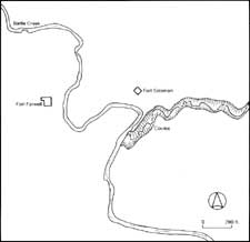
The site of the Cypress Hills massacre. The
precise location of the Indian camp is unknown, but it must have been
east of Battle Creek and south of the coulee. The ground to the north
of Fort Soloman rises abruptly; more gradual slopes dominate the valley
west of Fort Farwell and east of the site of the Indian camp. (Map by
S. Epps; click on image for a PDF version)
©Minister of Supply and Services Canada,
1979
|
In the fall of 1872 Abel Farwell arrived from Fort Benton and built
his fort, a collection of palisaded huts, about 100 feet from the
nearest point on the stream and 600 feet in a straight line from the
point where the coulee joins the creek. Facing Farwell's fort in
friendly rivalry was one built by Moses Soloman at about the same time.
[1] Fort Soloman was square with bastions.
The main building was L-shaped, with two walls of log palisade to fill
out the complex into a square or rectangular shape. The lone gate could
be locked against intruders by what the watchman later called "a log
chain." [2] The fort was 150 feet roughly
northwest of the nearest point on the coulee and 600 feet from Fort
Farwell. The third feature of human habitation in the area was the
Indian camp, a cluster of 40 or more lodges on rising ground south of
the coulee. At no point was it closer than 42 feet from the coulee and
it was probably at no point closer to the creek than about 50 feet. [3] It was therefore more than 600 feet from
Fort Farwell, on the opposite side of the stream.
For years the exact configuration of the massacre ground was in doubt
and the reputed locations of the two forts and the Indian camp rested on
the slim evidence of an old Métis who had herded cattle on the
site seven or eight years after the massacre. Over 50 years later, he
pointed out to interested individuals the site where he had once found
human bones and that, it was decided, must be the campsite. This
recollection of Jules Quesnelle was a useful indication, but by no means
decisive. [4] The issue was left further in
doubt when amateur archaeological efforts in the mid-1940s failed to
turn up evidence of the body of Ed Legrace, who was known to have been
buried under Fort Soloman. [5] In 1972 the
National Historic Parks and Sites Branch began historical and
archaeological research to find the exact locations of the two posts and
the Indian camp. Documentary research failed to turn up a contemporary
map of the massacre site (though one was drawn in 1875), [6] but did confirm that the traditionally
ascribed location satisfied the measurements taken on the site by the
Mounted Police in 1875. Part of the traditional story was given dramatic
confirmation by the archaeological efforts by Jack Elliott on the
supposed site of Fort Soloman. He discovered there a skeleton which
appears to be that of an adult male, buried by whites. The grave
provided no objective means of determining that the remains were
definitely those of Legrace, [7] but the
burial coincides with the supposed location of Legrace's grave. The
region has a sparse history of white settlement and it is unlikely that
another, unrecorded burial would have taken place at that spot. Elliott
also found evidence of log structures dating from after 1850 under the
site of Fort Farwell. Assuming, then, that the two trading posts have
been correctly located, the documentary evidence makes it clear that the
Indian camp stood on the south side of the coulee, east of the creek and
far enough up the slope to be visible from both forts.
Such was the scene of the Cypress Hills massacre. On the west side of
the creek stood Fort Farwell; opposite were Soloman's post and the
Indian camp. A fragile balance had been preserved between the whites and
the successive bands of Indians who had occupied that encampment. Then,
on the eve of Farwell's departure from the hills, the Benton party
arrived. Their presence, their gross intemperance, would destroy
everything. Before they left, death swept down the valley; all human
habitation became smoking ruins. The passage of seasons and the flooding
of Battle Creek soon erased all but a shadow of the forts and the
campsite, but nothing has washed away the notoriety which the massacre
of 1873 gave to the Cypress Hills.
|
