 |
|
Canadian Historic Sites: Occasional Papers in Archaeology and History No. 15
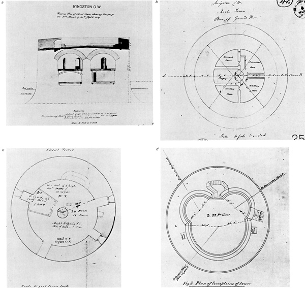
by Donald A. Harris IntroductionThe Market Shoal tower is located 100 yd. offshore in Kingston Harbour at 76°28'43"W. latitude, longitude 44°13'44"N. The tower stands between the Government Wharf and Swift's Wharf at the foot of Brook Street, directly in front of the Kingston City Hall. The water depth in the immediate vicinity of the tower ranges from 2 ft. to 9 ft. During the winter the tower is accessible by an ice bridge, but during the rest of the year it can only be reached by boat. Adjacent to the tower is a breakwater which creates a small boat basin to the west. The tower (Fig. 2) was constructed of hewn limestone on an ovoid plan to a height of 45 ft. The long axis of this oval, oriented north and south, is 65 ft. and the short axis is 60 ft. The southern section of the structure's wall is 5 ft. thicker than the other sides. This additional thickness was a result of the need for greater protection from that quarter, or to provide the space needed for a staircase, or both. Inside the tower, however, the plan is circular with a radius of 20 ft.
This tower was the only one of the four in the immediate area that was constructed on a circular plan. The other three were built on octagonal bases that merged into circular plans at the tops of the towers (Laveil 1936:163). At the bases of these other towers small caponiers opened onto a moat to further protect them, but this defence was not necessary at the Shoal tower. In 1972 this tower was the object of a cleaning contract and as the work proceded it became apparent that some archaeological research was necessary if a large amount of data concerning the interior layout of the tower was not to be lost. Hence in February of that year, the author and Gerry Crockett from the Technical Services Branch of Indian and Northern Affairs proceeded to excavate and record the interior of the tower. The author would like to thank Mr. Crockett for his assistance and copies of all his sketches and drawings, and also Graham Barkley of the Central Region Office of the National and Historic Parks and Sites Branch for all of the arrangements he was able to make facilitating the smooth operation of the research. Finally, the author expresses his appreciation for the cooperation and assistance provided by Mr. Armand Leduc, superintendent of the cleaning operation. |
||||||||
|
||||||||