A Brief History of Canada's National Parks
Chapter 5
North of Sixty
Introduction
In February 1972, the Minister of Indian Affairs and Northern Development, Jean Chrétien, announced that more than 48,000 km2 in the Canadian North had been set aside for three new national parks.
These lands, in the Kluane area in the Yukon Territory and along the South Nahanni River and on the Cumberland Peninsula of Baffin Island in the Northwest Territories, would become Canada's first national parks north of the 60th parallel.
The three northern parks would increase the total area in Canada's system of national parks by more than 50 per cent, from 81,000 km2 to 129,000 km2 and, for the first time, the system would represent outstanding natural areas in every province and territory.
The minister had discussed the land withdrawals for the new parks with the commissioners of both territories and with the territorial councillors. All groups directly affected by the withdrawals had been given an opportunity to make their views known.
All parties understood that the federal government would not allow the proposed parks to affect in any way the traditional use of wildlife and fish resources by the northern native peoples. The parties also agreed to ensure that the Indian and Inuit peoples living near the parks would have a share of the jobs created and of every other economic advantage provided by the parks.
The National and Historic Parks Branch of the Department of Indian Affairs and Northern Development assumed responsibility for the administration and control of the lands and began to prepare development plans pending Parliament's consideration of amendments to the National Parks Act.
The 1974 amendments contained important provisions to respect the process of settling native land claims. Lands set aside for national park purposes were given the legal status of "reserves" pending settlement of the claims. As claims affecting lands reserved for a national park are settled, those reserves may, by further proclamation of Parliament and amendment to the Act, become legally known as national parks.
The government thought it was important to set aside lands in remote areas for future generations of Canadians — northerners and southerners — who might face unforeseen pressures, and its northern policy recognized the need to balance development to both benefit the people and protect the environment. The government believed that the national parks would stimulate tourism and provide economic and social opportunities for northern residents.

Mount Logan, Kluane National Park Reserve
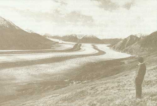
Kaskawulsh Glacier, Kluane National Park Reserve
Kluane National Park Reserve
Kluane National Park, in the southwestern corner of the Yukon Territory, contains Canada's highest mountains and most spectacular icefields and some of North America's most remarkable wildlife populations. The 22,000-km2 area encompasses most of the land set aside as the Kluane Park Reserve in 1942 and the Kluane Game Sanctuary in 1943.
Natural History
The St. Elias Mountains, among the most impressive in North America, run through the park in a southeasterly direction. Mount Logan, at 6,050 m, is Canada's highest peak. The extensive icefields of the St. Elias form one of the world's largest non-polar glacier systems. Remnants of the last Ice Age, these massive fields of snow and ice are sustained by moisture-laden Pacific air that flows over the mountains.
The Steele glacier is unusual because it sporadically moves at a very rapid rate. In the late 1960s, it surged downhill 488 m in one month. The Kaskawulsh and Lowell glaciers are outstanding examples of the moraine-flanked glaciers typical of the area. Other interesting geological features in the park include glacier-created sand dunes and deltas built by dust storms. In Kluane Lake, a large delta has been formed by the accumulation of wind-blown deposits from the Kaskawulsh glacier.
Flora and Fauna
Coniferous species such as white spruce are typical of the boreal forest growth of the river valleys. The vegetation is most luxuriant in the southeastern section of the park, as a result of the climatic influence of the Pacific Ocean. At altitudes of 1,500 to 1,800 m in the northern section, lichens, dwarf birch, and low shrubs embellish the tundra. Colourful arctic flowers grow from crevices and on rocky ledges of the mountains.
Arctic grayling, lake trout, northern pike, and ouananiche (landlocked salmon) are found in most of Kluane's lakes and streams. Large populations of golden eagle and ptarmigan inhabit the area, and the bluebird, once common to southern Canada, also nests here.
The world's last major bands of Dall's sheep live in the mountains; large numbers of moose inhabit the sub-alpine region; and caribou occupy the park's northern tundra uplands. The park is also home to mountain goats, wolves, and wolverines. The grizzlies of Kluane, which are smaller and more solitary than those found elsewhere, are rarely seen in groups.
Human History
During the Klondike Gold Rush of 1898, one of the routes for travellers from the Pacific was near the southeastern boundary of Kluane. Dalton Post, just outside the park, was a stopover camp. After the gold rush, prospectors travelled to other parts of the Yukon, and in 1904 the North-West Mounted Police established a control post on the south shore of Kluane Lake. In 1942, Kluane Lake was the meeting point for American and Canadian crews building the Alaska Highway.
Since the late 1800s, the St. Elias Mountains have been popular with mountaineers. Mount Kennedy, named for the American president, was climbed in 1965. During Canada's centennial year, other peaks were climbed and named for each province and territory.
Access
Kluane National Park lies 161 km west of Whitehorse and 2,253 km northwest of Edmonton. At Haines Junction, the Haines Road from the Pacific coast joins the Alaska Highway, which runs 129 km along the park's northern boundary. There is daily airline service to Whitehorse from Vancouver and Edmonton.
Nahanni National Park Reserve
Nahanni National Park is a 4,765-km2 wilderness area containing the major portion of the South Nahanni, one of North America's finest wild rivers.
Natural History
Draining an area of more than 36,000 km2, the South Nahanni watershed contains a number of strikingly different landscapes. The upper reaches flow through tundra-capped mountains inhabited by mountain goats, Dall's sheep, and caribou. At the northern edge of the park rise the peaks of the Ragged Range, location of Hole-in-the-Wall Lake and a 41° C hotspring. In the valley below, 20° C water from Rabbitkettle Hotsprings has formed a succession of terraces more than 27 m high.
The major cataract of the South Nahanni is Virginia Falls, where the river plunges more than 91 m. Twice the height of Niagara Falls and the most spectacular undeveloped waterfall in Canada, it shows more than 1.5 vertical hectares of waterface shrouded in mist. Several kilometres below the waterfall, tumultuous rapids and whirlpools mark the river's journey through a tortuous constriction known as Hell's Gate. Ten kilometres below Hell's Gate, the Nahanni is joined by its largest tributary, the Flat River.
Below this confluence lies Third Canyon, 19 km long and from 900 to 1,200 m deep. The Gate, a hairpin turn at the bottom of the canyon's 213-m vertical cliffs, is guarded by Pulpit Rock. Then the South Nahanni flows only a short distance before entering the narrow, steep-walled Second Canyon, which crosses through the Headless Range. Between Second and First canyons lies the wide gravel delta of Deadmen Valley. The precipitous walls of First Canyon, untouched by icesheets during the last glaciation, rise some 1,067 m, and the canyon's many caves are the first found north of the 60th parallel.
At the mouth of First Canyon, pools of 36° C water have collected below a sulphur hotspring and the immediate area supports a luxuriant growth of grasses, balsam poplar, and spruce. Between Yohin Ridge and the Twisted Mountain, the South Nahanni passes near Yohin Lake, a shallow, marshy lake providing ideal habitat for large numbers of waterfowl and an unusual growth of plants.
Eleven kilometres southeast of Yohin Lake, on the slopes of the Liard Range, wind and water erosion has sculptured spectacular sandstone arches, pedestals, and shallow caves. Powder-like sand from these formations covers the ground.
Flora and Fauna
More than 40 plants not previously recorded in the Mackenzie Mountains area have been identified in the park. For several species, growth in this area is a significant extension of their common range. Wild mint, goldenrod, yellow money-flower, and aster are among the many flowering plants growing in abundance near mineral springs along the Flat River. Large numbers of orchids are found near Virginia Falls.
The forests in the lowlands are composed of mainly boreal species. White spruce and balsam poplar dominate the dense growth along the valley bottoms. At higher altitudes and on northern slopes, black spruce becomes more prominent. Sedges, lichens, grasses, and shrubs cover the alpine tundra on the higher mountains in the Tlogotsho, Headless, and Funeral ranges. These regions and the steep cliffs of First Canyon are inhabited by Dall's sheep.
Nahanni contains more than 40 species of mammals. The forested river valleys provide prime habitat for moose and beaver, and the upper valleys for woodland caribou. Black bear and deer have been observed in the park. At least 13 species of fish, including arctic grayling and Dolly Varden trout, are found in the streams that flow into the Nahanni and Flat rivers.
More than 120 species of birds, including the golden eagle, Canada goose, American coot, wandering tattler, violet green swallow, and song sparrow, have been recorded in Nahanni.
Human History
The earliest inhabitants of the Nahanni area might have been Asiatics who were lured across the Bering Strait by the abundance of fish and game. Two nomadic Athapaskan tribes — the Slavey Indians and the Nahanni, meaning "people over there far away" — lived here as late as the 18th century. Their linguistic kinship with the peoples of eastern Asia can still be identified.
Early in the 1800s, the Northwest Company, and later the Hudson's Bay Company established trading posts along the Mackenzie River to support the fur trade, and the nomadic ways of the Indians came to an end.
Not until the early 20th century, however, did the Nahanni become a land shrouded in myths and legends. Tales of rich placer gold deposits lured prospectors to the area, and the later discovery of the headless bodies of some of these adventurers generated legends of fierce natives and mythical mountain men. In recent years, perhaps in response to the legends, there has been little trapping or prospecting.
Access
Nahanni National Park lies 145 km west of Fort Simpson, N.W.T., and 1,046 km northwest of Edmonton, Alberta. There are no roads to Nahanni. Access is by air or water. Fort Simpson, Fort Liard, Fort Nelson, and Watson Lake, Yukon, are the major jumping-off and supply points. All centres except Fort Liard are served by regular air service and all-weather highways via Edmonton. Charter aircraft are available at all centres. Nahanni Butte, at the mouth of South Nahanni River, has an earth airstrip, but limited fuel and few supplies are available. The Liard Highway links Fort Nelson, B.C., on the Alaska Highway, with Fort Simpson, N.W.T., on the Mackenzie Highway, which was opened in 1984. It passes within 30 km of Nahanni Butte and provides access to the Liard River at Blackstone Territorial Park, east of Nahanni National Park.
Auyuittuq National Park Reserve
Auyuittuq National Park, on the Cumberland Peninsula of Baffin Island, is representative of the vast arctic regions that make up more than one-third of the Canadian landscape. This 21,471-km2 area lying along the 66th parallel contains spectacular fiords and deeply carved mountains dominated by a massive icecap.
Natural History
Auyuittuq's arctic coastline is incised by roughly graded valleys and fiords as long as 48 km, with vertical cliffs rising 914 m or more above the sea. The Penny Highlands lie inland. Mountains reaching 1,829 to 2,134 m are crossed by long, narrow valleys, many of which are filled with glaciers. Pangnirtung Pass, 97 km long and as deep as 1.6 km, is essentially icefree in summer and supports extensive tundra.
The Penny Ice Cap, which rises from 610 m in the northwest to more than 1,829 m in some areas, dominates the highlands. Covering 5,698 km2, it is one of the largest icecaps in the northern hemisphere. Coronation glacier, the largest of the many long glaciers that extend from the cap, is 32 km long and 3 km wide. Bordering the highlands is rolling, hilly terrain covered with boulders and moraine. Isolated icefields occur in a few mountainous areas of the uplands where the peaks rise to 1,829 m.
Flora and Fauna
Whale, narwhal, seal, and walrus frequent the waters of Auyuittuq's fords. Terrestrial mammals inhabiting the park include arctic fox, barren-ground caribou, and the endangered polar bear. Several other endangered species — atlantic walrus and blue, humpback, and right whales — are also found in the area.
Canada goose and snowy owl are among the 40 species of birds that nest here, and rare species such as the gyrfalcon and whistling swan are also found.
The tundra in the river valleys and Pangnirtung Pass supports an almost continuous cover of lichen and moss heath, with a few dwarf shrubs. Frost polygons, soil patterns caused by the cycle of freezes and thaws, are found in the marshy lichen areas of Pangnirtung Pass. The boulders in the rock-strewn barrens of the uplands are often covered with crustaceous lichens and, during the summer, flowering plants such as arctic poppy and saxifrage cover the rocky slopes in brilliant colours.
Human History
One thousand years ago, Baffin Island was a site of the Thule culture. Archaeologists have discovered the ruins of several Thule communities in the area of Cumberland Sound. Today there are two Inuit settlements near the park, one at Pangnirtung, at the mouth of the Pangnirtung Fiord, and the other on Broughton Island, off the northwest coast of the peninsula.
Access
Auyuittuq National Park is 2,575 air kilometres northeast of Montreal. A commercial airline operates a daily jet service to Iqaluit (Frobisher Bay), 290 km from the park, and regular service to Pangnirtung, 32 km from the southern boundary.
Northern Yukon National Park
In June 1984, Parliament approved a bill to establish Northern Yukon National Park. Covering an area of about 10,000 km2, the new park extends from the western portion of Yukon's North Slope, on the Beaufort Sea, along the Yukon-Alaska boundary to the height of land and watershed in the South and to the Babbage River in the east.
Canada — COPE Agreement
The park was established as a result of an agreement between the Government of Canada and the Committee for Original People's Entitlement (COPE). The traditional hunting, trapping, and fishing rights of the Inuvialuit people will be respected within the new park.
The northern Yukon is a spectacular wilderness area and a superlative wildlife habitat. It is a major North American waterfowl area and contains an important migration route and calving ground for about 100,000 animals of the Porcupine herd of barren-ground caribou. North America's three bear species, the grizzly, the black bear, and the endangered polar bear, are all found within the park.
The development plans for Northern Yukon National Park will emphasize its wilderness character.
Ellesmere Island National Park Reserve
In September 1986, the federal Minister of the Environment and the Minister of Economic Development and Tourism of the Government of the Northwest Territories signed an agreement to establish Ellesmere Island National Park Reserve.
Most Northerly Lands
The park reserve covers 39,500 km2 of the most northerly lands in Canada and includes mountain ranges, glaciers, fiords, and Lake Hazen, the largest lake north of the Arctic Circle.
Ellesmere Island, which lies 2,500 km northeast of Yellowknife, is a land of long, harsh winters and brief, cool summers, of cold, dry winds and very light snowfalls. As a result, most of the area is a polar desert — windswept and arid, with few plants and little animal life.
Thermal Oases
Yet, despite the severe climate, areas of thermal oasis, such as the one around Lake Hazen, are moist and warm enough to support vegetation and to maintain animal life. These areas are known for their large populations of arctic hare, which often gather in the hundreds. Small herds of musk-oxen roam where there is suitable food, and Peary caribou can be found in small groups throughout the region. A few wolves, arctic fox, and polar bears are the primary predators in the area. About 30 species of birds visit the Queen Elizabeth Islands.
One of the most significant aspects of the land is its fragility and susceptibility to environmental damage. The national park reserve is protected under the National Parks Act to ensure that its features are preserved for posterity. Care will be exercised in the planning, management, and public use of the park reserve to maintain unimpaired the area's wilderness values and sensitive features.