A Brief History of Canada's National Parks
Chapter 1
The Early Years (Up to 1900)
Introduction
The year 1885 was a momentous one for Canadians. Its annals recorded the fulfilment of a long-cherished national dream—the linking of eastern Canada with the Pacific coast by a transcontinental railway. It witnessed the early settlement of the Prairies and the suppression of an armed rebellion by Indians and half-breed residents of the North West Territories against the Government of Canada. The closing months of the year also chronicled the reservation for public use of mineral hot springs in the Rocky Mountains near the railway station of Banff, the first step in the development of Canada's unique and wide-spread system of National Parks.
Over the years, the term "park" has enjoyed a broad definition, ranging from small landscaped enclosures to extensive primitive areas. In mediaeval Europe, parks, some of substantial size, were a recognized institution. The New Forest in southwestern Hampshire, England, afforested by William the Conqueror in 1079, and the Great Park at Windsor are examples. The first edition of the Encyclopaedia Britannica, published at Edinburgh in 1771, defines "park" as "a large enclosure privileged for wild beasts of chace (sic) either by prescription or the King's grant".1 Since these early parks functioned as hunting areas for a privileged minority, their preservation was essential and obviously they helped to perpetuate native wildlife and a necessary wilderness condition. Outside these reserves, arable land was generally cultivated intensively and most original forms of wildlife risked extinction.

Banff, 1887
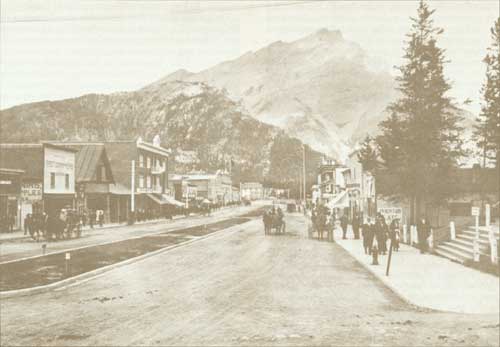
Banff, 1913
The National Park Idea
Happily, over the years, the word "park" has earned a wider connotation, and in North America, "National Park" defines an area set aside as a public heritage or trust, to preserve forever outstanding examples of a nation's scenery, wilderness, geology, natural phenomena or native flora and fauna. Instead of forming private preserves, these parks are dedicated to public use and enjoyment by the citizens of the country to which they belong. Since its inception during the latter part of the nineteenth century, the national park movement has spread until every continent and most large nations now have national parks.
Canada's first national park owed its creation to far sighted legislators who realized that natural phenomena in the midst of scenic magnificence should be preserved and administered as a public rather than a private enterprise. The construction of the first transcontinental railway had brought hundreds of adventurous and ambitious young men across the western plains to the Rocky Mountains. Here among the towering peaks, some of them discovered mineral hot springs flowing from the mountainside. Conflicting claims of discovery brought these remarkable discoveries to the attention of the Government of Canada. With the option of granting title and the privilege of development to private individuals, the Minister of the Interior decided instead to retain the springs and surrounding lands as a national possession, in order that they might have the greatest possible use and enjoyment at minimum cost by Canadians and their guests. A backward glance over the events which preceded this historic decision may be of interest.
Early Exploration
Less than a decade before the coming of the railway, the mountain region of Western Canada embracing the Canadian Rockies was relatively unknown, except to the native Indians and to the traders, explorers and others who had penetrated its forbidding passes. Early travellers including David Thompson, Sir George Simpson, Father Pierre de Smet and Dr. James Hector of the Palliser Expedition had left written records of their experiences, but to others, lacking the stimulus and the resources for planned exploration, the lofty summits, deep valleys and primeval forests west of the great plains were an unknown country, primitive, trackless and virtually inaccessible.
Although the "search for the western sea" had been carried on by North American explorers from the earliest days, only in the early part of the nineteenth century were the central Canadian Rockies first explored. Alexander Mackenzie had reached the Pacific coast in 1793 from Fort Chipewyan on Lake Athabasca by way of the Pine, Peace, Parsnip, Fraser, Blackwater and Bella Coola Rivers.2 David Thompson and Duncan McGillivray, in the employ of the North West Company, penetrated the eastern Rockies up Bow River in 1800 to a point near present-day Exshaw.3 Later in 1807, Thompson, an indefatigable traveller, crossed the Rockies from Rocky Mountain House just north of Lake Windermere, headwaters of the Columbia River.4 Thompson's reputation as an explorer was further enhanced by his discovery and crossing of the Athabasca Pass in the winter of 1810-11. The summit was reached in January, 1811, when camp was made on 6 m of snow. This crossing established a route used in later years by the annual fur brigades on their way to Fort Edmonton from the Pacific Coast.
The tortuous route over Athabasca Pass known as the "Athabasca Trail" later was supplanted by an easier one over Yellowhead Pass to the north. This new access to the Pacific, by way of Fraser River, appears to have come into use about 1826.5 Years later in the twentieth century, it was to be selected as the route for the trans-continental lines of the Grand Trunk and Canadian Northern railway companies, since amalgamated as Canadian National Railways.
A new route across the central Rockies was pioneered in 1841 by Sir George Simpson, Governor of the Hudson's Bay Company, in the course of his journey around the world. Simpson's account of his travels form the first documented account of the penetration of the Bow River Valley past the present town of Banff.6 Led by a Cree Indian guide, Simpson followed an Indian trail through Devil's Gap, circled Lake Minnewanka, and followed Bow River westerly to the mouth of Healy Creek. From there, the creek was followed to a point on the continental divide now known as Simpson Pass. Simpson was enchanted with the alpine uplands and his description of the area expressed his delight in observing the presence of mountain heather.
From the vicinity of perpetual snow we estimated the elevation of the height of land to be seven or eight thousand feet above the level of the sea, while the surrounding peaks appeared to rise nearly half of that altitude over our heads ... In addition to the physical magnificence of the scene I here met an unexpected reminiscence of my own native hills in the shape of a plant which appeared to me to be the very heather of the Highlands of Scotland and I might well regard the reminiscence as unexpected in as much as in all my wanderings for more than twenty years, I had never found anything of the kind in North America. As I took a considerable degree of interest in the question of the supposed identity, I carried away two specimens, which, however, proved upon minute comparison to differ from the genuine staple of the brown heaths of the "land o'cakes."7
More than 80 years later James Brewster of Banff discovered, in the pass, a fallen tree trunk bearing the initials GS-JR 1841, believed to be those of Simpson and James Rowand, Chief Factor of the Company, who accompanied Sir George on the mountain crossing from Fort Edmonton to Kootenay River and the company posts on the Columbia River and Pacific Coast.
Missionary Travels
Four years after Simpson's traverse of the Rockies, Father Pierre de Smet, a Jesuit missionary, crossed White Man's Pass on his journey from Oregon Territory to the western plains, where he had planned to visit the Blackfeet Indians. On his return journey from Fort Edmonton, Father de Smet selected Athabasca Pass as his return route across the Rockies, by way of the Athabasca, Whirlpool and Wood Rivers. His journey up the Athabasca Valley was broken by a stop-over in the vicinity of Jasper House, a North West Company trading post. Here he spent more than three weeks, baptizing and marrying the native Indians and, incidentally, fasting to reduce his weight for the strenuous passage across the mountains. As his party made the ascent of the pass, they met a fur brigade of the Hudson's Bay Company from Fort Vancouver in the charge of Edward Ermatinger.8
Another missionary, the Reverend Robert T. Rundle, left in his journal a record of a visit to the present site of Banff in 1847. Rundle had reached Bow River outside the mountains in 1841, and six years later his Indian guides brought him to the foot of Cascade Mountain where he camped for several days.9 Although the records left by these pioneer missionaries do not contain much scientific information, the accounts of their travels through primitive wilderness regions now included in national parks provide an interesting commentary on means of transportation, the physical effort involved, and the dependence on native fish and game for daily sustenance.
The Palliser Expedition
Shortly after the middle of the nineteenth century, the scientific exploration of western Canada including the mountain region beyond the plains was undertaken by the Palliser Expedition. Authorized by the Government of Great Britain, it was organized to explore the North West Territories of Canada for opportunities of immigration and settlement, and also to find, if possible, a suitable route for a road or railway across the Rocky Mountains to connect posts and settlements on the western coast with the eastern colonies. Motivating this broad program in part were the explorations undertaken south of the International Boundary by the United States Government. In 1853, the Secretary of War had been authorized by the President of the United States to carry on explorations and surveys that would determine the most practical and economic route for a railroad from the Mississippi River to the Pacific Ocean and thus connect the states on the Atlantic with those on the Pacific Coast. As Captain Palliser pointed out in the foreword to his report, successive parties organized by the United States Government had compiled reports which, on publication, had filled "twelve large quarto volumes abounding with valuable information of every kind respecting the country and embellished with views of scenery".10 Conversely, the physical characteristics of some portions of British North America lying between the western shore of Lake Superior and Okanagan Lake and north of the International Boundary were well known, especially in the vicinity of Red River where the Selkirk settlement had been made. Also known were the valleys of the Assiniboine and the North Saskatchewan Rivers along which the Hudson's Bay Company had established trading posts. The southerly portion of the country along the South Saskatchewan River remained comparatively unknown. Although Sir George Simpson had described his crossing of the Rockies in 1841, and James Sinclair had guided parties over the same route to Oregon Territory on the Pacific Coast, specific information on the difficulties encountered and how they could be avoided or removed was not available. Captain Palliser's program included exploration of the portion of British North America which lay between the north branch of the Saskatchewan River and the International Boundary and the Red River and Rocky Mountains. He was also instructed to "ascertain whether one or more practical passes existed over the Rocky Mountains within British Territory and south of that known to exist between Mount Brown and Mount Hooker (Athabasca Pass). Palliser also was authorized, if he so desired, to proceed westward from the Rocky Mountains to Vancouver Island".11
As leader of the expedition, Captain Palliser had as associates Dr. James Hector, a geologist; Lieutenant Thomas Blakiston, Royal Artillery; Eugene Bourgeau, a botanist; and John W. Sullivan, who served as secretary of the expedition. The first season's work in 1857 was confined mainly to the Great Western Plains whereas in 1858 exploration was extended westward into the Rocky Mountains and beyond. Most of the known passes over the continental divide north of the International Boundary were explored by parties of the expedition. Palliser led his group in 1858 from Fort Carlton to the Bow River and over Kananaskis Pass to the Kootenay River, returning to Fort Edmonton by way of Kootenay Pass, farther south. The following year, Palliser explored territory west of North Kootenay Pass to the Columbia River. Later he made his way to the Pacific Coast and reached Fort Vancouver on the Columbia River. From that point he sailed to Fort Victoria on Vancouver Island. Lieutenant Blakiston's expedition explored the area east and west of the North and South Kootenay Passes, including lands now included in Waterton Lakes National Park.
Dr. Hector's Discoveries
The most interesting explorations, in the light of later developments in the Canadian Rockies, were those undertaken by Dr. (later Sir James) Hector. Dr. Hector's explorations in 1858, on which he was accompanied by Eugene Bourgeau, the expedition's botanist, took him up Bow River past the future site of Banff.12 On August 15, he camped on the "little prairie" at the foot of the "mountain where the water falls" (sic, Cascade Mountain). A detour made southwesterly over Vermilion Pass brought him to the Vermilion and Kootenay Rivers over a route to be selected more than 50 years later for the Banff-Windermere Highway. Hector then pushed his way northeasterly up the Kootenay to its source, then down the Beaverfoot River to the Kicking Horse River, so named as a result of an accident sustained by Hector. This is how he described the incident that led to the naming of one of the most famous and much-travelled passes in Canada.
August 29th ... A little way above this fall, one of our pack horses, to escape the fallen timber, plunged into the stream, luckily where it formed an eddy, but the banks were so steep that we had great difficulty in getting him out. In attempting to recatch my own horse, which had strayed off while we were engaged with the one in the water, he kicked me on the chest, but I had luckily got close to him before he struck out, so that I did not get the full force of the blow. However it knocked me down and rendered me senseless for some time. This was unfortunate as we had seen no tracks of game in the neighbourhood and we were now without food; but I was so hurt that we could not proceed further that day at least. My men covered me up under a tree and I sent them all off to try and raise something to eat. August 31st—After travelling a mile along the left bank of the river from the northwest, which because of the accident the men had named Kicking Horse River, we crossed to the opposite side.13
At the time of Hector's accident, his party had run short of food. Living off the land, Hector discovered that game was very scarce on the western side of the continental divide, and only a small amount of pemmican remained of their stores. Proceeding easterly up the river, the party crossed the continental divide. During an overnight stop in Kicking Horse Pass, Hector was on the point of killing one of his horses for food when his Indian guide, Nimrod, fortunately shot a moose.
Hector next turned northerly up Bow River, following the future route of the Banff-Jasper Highway to the North Saskatchewan River. After a digression westward to Glacier Lake, Hector and his party descended the North Saskatchewan to Rocky Mountain House, and from there went on to Fort Edmonton. During the latter part of the journey through the mountains, game was quite prevalent and the party fared well. The guide, Nimrod, recalled the presence of buffalo in numbers along the North Saskatchewan well within the mountains, before they had died out, along with other species of game, during what must have been an outbreak of disease.14
Early in 1859, Hector set out from Fort Edmonton in winter for Jasper House on the Athabasca River. This proved to be a rigorous excursion along the route now followed closely by the Canadian National Railway. Most of the journey was made on snowshoes with supplies transported on sleds drawn by dogs. Before reaching the Hudson's Bay Company post, which had recently been reopened for trading, the party waded the Athabasca River waist deep with the temperature at -26°C (January 31). Following this icy crossing, the party reached Jasper House at 10:00 p.m., where they were welcomed by a Mr. Moberley, the company trader. From Jasper House, Hector and his party made several excursions including trips up Snake Indian, Whirlpool and Athabasca Rivers during which he named many of the mountains in the Athabasca Valley in the vicinity of Jasper. The return to Edmonton was made between February 16 and March 6 in the same year.
Hector's second trip up the Bow River Valley was undertaken in August, 1859, from a camp at the site of Old Bow Fort. That year the party turned north from a point near the present Lake Louise Station, crossed Pipestone River and followed its valley to Pipestone Pass. Descending the Siffleur River to the North Saskatchewan, the party turned westerly and explored the icefields at the head of Howse River, crossed Howse Pass and reached the Columbia River by descending the Blaeberry. Hector then followed the Columbia to its headwaters, and made his way to Fort Colville, where he rejoined Captain Palliser. In the course of his explorations over two years, Hector had travelled routes which, long years after, were to be utilized in both railway and highway construction across the Rockies.
Captain Palliser's Conclusions
In his report to the Colonial office in London, Captain Palliser expressed the opinion that four passes provided opportunity for the construction of wagon roads over the Rockies that would provide connection between the plains of Saskatchewan and the Columbia River valley. These included the North Kootenay, Kananaskis, Vermilion and Kicking Horse passes. Of the four, the Vermilion Pass was favoured, as the ascent to the summit was the most gradual of them all. Palliser also reported that although a connection of the Saskatchewan plains with a known route through British Columbia had been effected by the expedition without passing through any portion of United States territory, available knowledge of the country would never lead him to advocate a line of communication from Canada across the continent to the Pacific exclusively through British territory.15 Fortunately, this opinion in years to come would be disproved many times.
Postscript to Dr. Hector's Travels
Dr. Hector (now Sir James) returned to the scene of his explorations in the Canadian Rockies more than forty years later. In 1903, he sailed from New Zealand across the Pacific to Canada, accompanied by his younger son Douglas. He was a guest of the Canadian Pacific Railway Company at Glacier House in Glacier National Park. On arrival at the hotel on August 12th the son showed symptoms of illness and was taken to the hospital in Revelstoke. There he died and was buried in the shadow of the mountains bordering the Columbia River which his father had explored many years earlier. Dr. Hector's visit was recorded in the Glacier House Register by Mrs. Charles Schaffer, who concluded her account of the tragedy as follows:
The father, his heart too heavy to continue his journey, or to carry out his plans, that night turned his face westward, returning to New Zealand by the vessel that had borne both to the Canadian shore.16
Before leaving, Sir James had his photograph taken with Edward Whymper, the famous Alpine climber and first conqueror of the Matterhorn, whom he had just met for the first time.
Exploration Beyond the Mountains
From the early part of the nineteenth century, the Hudson's Bay Company and its rival, the North West Company, had been extending the fur trade beyond the mountains of British North America. The union of the two companies in 1821 had ended ruinous competition and the surviving Hudson's Bay Company had expanded its operations to the Pacific. The establishment of posts along the rivers flowing into the Pacific, including the Columbia, had established for Britain a claim to what was known as the Oregon Territory. The Oregon Treaty of 1846, however, had determined the 49th parallel as the International Boundary between British North America and the United States and, while confirming Vancouver Island as British territory, had ended British sovereignty over the Oregon region.
The Hudson's Bay Company had established Fort Victoria at the southern end of Vancouver Island in 1843.17 In 1849, the Imperial Government in London, concerned with the desirability of colonizing at least a part of the Pacific coast, made a grant of the entire island to the Company with the latter responsible for colonizing the island.18 Following the depletion of the gold fields in California, miners had turned their eyes northerly when gold was discovered in the sandbars of the Fraser River in British territory. In August, 1858, Governor Douglas of Vancouver Island estimated there were 10,000 miners in the valley of the Fraser.19 Concerned over the influx of Americans into British territory, Governor Douglas, without authority, took steps to control mining and trade on the mainland. Steps were taken by the Imperial Government to constitute the mainland a Crown Colony and this was accomplished in August 1858. Later in 1866, the two colonies were united by an Imperial Act of Parliament.
British Columbia Enters Confederation
By 1860, both the British Government and that of Canada were concerned with the need of communication between the Crown Colony of British Columbia and Vancouver Island and the provinces of Upper and Lower Canada. The indefensible position of the British Columbia colonies lying separate without railway communication along the United States border also was a matter of concern. Among solutions discussed by promoters with the Colonial office in London were the purchase of the Hudson's Bay Company lands in western British North America; the creation of a new Crown colony; and the extension of the Grand Trunk Pacific Railway westerly to the Pacific coast. However, only after the movement for the union of the British North American colonies in eastern Canada was successful and confederation achieved in 1867 had the prospect of either railway or road connection appeared possible. In 1869, the Hudson's Bay Company surrendered its charter to Her Majesty the Queen and Rupert's Land again became Crown domain. In 1870, Great Britain transferred, by Imperial Order in Council, both Rupert's Land and the North West Territory to the Dominion of Canada. The Company retained its posts and certain specific lands, and continued to carry on an extensive fur trade and mercantile business. Canada paid to the Company, as compensation, the sum of £300,000. Out of the surrendered lands, Manitoba became, on July 15, 1870, the fifth province of Canada.
Transcontinental Railway Projected
In 1868, the Crown Colony of British Columbia had made formal application for admission to Confederation. The Colonial office at London, however, held the view that Rupert's Land and the North West Territory must be included in the Dominion before the admission of British Columbia could become practicable. After protracted negotiations in which financial arrangements played a prominent part, British Columbia was admitted to Confederation on July 20, 1871. Under the terms of the union, other than financial, Canada was to commence the construction of a transcontinental railway within two years and complete it in ten years. In turn, British Columbia would grant to Canada public lands for the construction of a railway not to exceed 32 km on each side of the line, for which Canada would pay the Province $100,000 per year in perpetuity. The relevant clause of the agreement dated July 7, 1870, reads:
The Government of the Dominion undertake to secure the commencement simultaneously, within two years from the date of the union, of the construction of a railway from the Pacific towards the Rocky Mountains, and from such point as may be selected east of the Rocky Mountains towards the Pacific, to connect the seaboard of British Columbia with the railways system of Canada, and further, to secure the completion of such railway within ten years from the date of union.20
Sandford Fleming, a Scot, who had gained extensive railway engineering experience in eastern Canada, was appointed chief engineer of the Canadian Pacific Railway. Fleming organized a general survey on a comprehensive scale, detailing 21 divisions employing 800 men. Walter Moberly, a Toronto engineer, with extensive road construction experience in British Columbia, was appointed district engineer. Moberly, who had discovered Eagle Pass in the Gold Range, favoured a route westward over Howse Pass, around the big bend of the Columbia River, over Eagle Pass, and on to the coast by way of Shuswap Lake, Thompson River and Fraser River to Burrard Inlet. As expected, he located a practical line over this route. Working in co-operation with Moberly, Roderick McLean, a former Inter-colonial Railway engineer, located an alternative route through Yellowhead Pass along Albreda Lake and the North Thompson River. In April, 1872, Moberly was notified by Sandford Fleming that the Government had decided to adopt the route through Yellowhead Pass.
It was the intention of the Government then headed by Sir John A. Macdonald that the railway would be built by a private company that would have to be assisted by grants of land in which the provinces concerned would share.
Two financial groups in eastern Canada were bidding for the contract of construction—one headed by Sir Hugh Allan of Montreal and the other by the Hon. David L. Macpherson of Toronto. Following the federal election of 1872, won by Prime Minister Macdonald, a charter was awarded to a company headed by Allan. Discussion of railway matters in Parliament in the session of 1873 precipitated the appointment of a Royal Commission. Its report disclosed that, prior to the election, the Conservative Government headed by Macdonald had accepted substantial contributions from Allan for political purposes. Out of the disclosures developed the "Pacific Scandal", culminating in the resignation of Sir John A. Macdonald in November, 1873, and the accession of a Liberal Government headed by Alexander Mackenzie. The contract for the construction of the railway was surrendered, and Mackenzie endeavoured to obtain a successor to Sir Hugh Allan. The terms offered brought no bidders, and consequently the new Government decided to build the railway by contract under the supervision of the Department of Public Works.
Government Railway Construction
Construction of the railway as a Government enterprise got under way a few kilometres west of Fort William on June 1, 1875. The general election of 1878 resulted in the return of a Conservative Government under Macdonald, and Sandford Fleming was instructed to commence construction in British Columbia. Fleming recommended a route along the Thompson and Fraser Rivers to Burrard Inlet. Contracts were let for 204 km of railway along the Fraser River to Andrew Onderdonk, an American engineer with a record of accomplishment. Onderdonk had financial backing from a syndicate of Americans and started work on the Pacific leg of the railway on May 14, 1879.21 Progress of the railway under government supervision from the Great Lakes westward was to be disappointing, although lines had been constructed from Selkirk eastward and also southerly to connect with an American railway at the International Boundary, which would make possible a connection between Winnipeg and St. Paul. By 1880, Prime Minister Macdonald had decided, in view of the difficulty in raising funds for railway purposes, to have construction taken over by private enterprise subsidized by the Government of Canada. Macdonald induced George Stephen, a wealthy merchant of Montreal and President of the St. Paul, Minneapolis and Minnesota Railway, to form a syndicate that would complete the Canadian transcontinental line. Negotiations were commenced in April, 1880, and the final contract was signed at Ottawa on October 21, 1880.22 Prime Minister Macdonald obtained approval in Parliament in February, 1881, for a bill ratifying the contract which provided for a subsidy of $25,000,000 and 10,117,500 ha of land, and completed sections of railroad from Selkirk to Lake Superior and from Kamloops to Port Moody.23 The syndicate, incorporated as the Canadian Pacific Railway Company, undertook to complete and equip the railway from the western terminus of the Canada Central Railway near the eastern end of Lake Nipissing to Port Moody on the Fraser River by May 1, 1891.
Rogers Pass Selected
The new company decided to relocate the crossing of the Rockies from Yellowhead Pass to a more southerly route, as it was believed a location nearer the International Boundary would result in a profitable traffic from the outset. Sandford Fleming was now out of favour and Major A.B. Rogers, an American engineer with wide railway construction experience, was placed in charge of the mountain division. Rogers was directed to find the shortest practical route from Savona's Ferry in British Columbia to Moose Jaw in the North West Territories. In May, 1881, Rogers located the pass over the Selkirk Mountains which bears his name and in July, 1882, made his way from the Columbia River by way of Beaver Creek to the summit of Rogers Pass and into the valley of the Illecillewaet River. In a letter addressed to W.C. Van Horne, general manager of the railway company, dated January 10, 1883, Rogers reported as follows:
On Monday. July 17th, (1882) I started from the Columbia with two white men and three Indians for another trip into the Selkirks by way of Beaver Creek; on the 24th I had succeeded in finding a practical line across the summit and into the east branch of the Illecillewaet and returned to camp on the 6th of August24
Following a thorough examination of the Bow River Valley by Major Rogers, the Kicking Horse Pass—first discovered by Hector in 1858—was selected as the most feasible route over the Rockies. By November, 1882, Rogers had completed the location of the railway eastward from the summit of Kicking Horse Pass for 64 km, and also westerly from the summit for a distance of 13 km, the section covering the heaviest work in the vicinity of the Columbia River. Final surveys in the Kicking Horse Valley were completed in 1883.25
Rocky Mountains Crossed
Although railway construction had proceeded with amazing speed across the prairies and the line had reached Calgary in August, 1883, doubt still existed in government circles that the route over Kicking Horse and Rogers passes had advantages over the Yellowhead Pass route. Sandford Fleming, who had been Chief Engineer of the government-sponsored railway from 1871 to 1881, was engaged to examine and report on the new location. Starting from Port Arthur in August, 1883, Fleming was accompanied by his son Sandford and Dr. G. M. Grant, principal of Queens University, Kingston. The party travelled over the completed railway route to Calgary. From there, Kicking Horse Pass was reached by wagon road. From the summit westerly, the route was rugged. The Kicking Horse River was followed down stream past the present site of Field, and through the tortuous lower canyon on horseback and on foot to the Columbia River, where the group was joined by Major Rogers.26 Rogers escorted Fleming and his party over Rogers Pass and down the Illecillewaet River to Albert Canyon over a trail cut for their benefit. From there on, the party struggled through a virgin wilderness to the Columbia River, where they were met by a party from Kamloops. Fleming and his companions continued on their way to the coast by way of Eagle Pass, Kamloops and Fraser River. The successful completion of Fleming's inspection marked the first continuous journey made over the route selected for the Canadian Pacific Railway, and dispelled further concern about the suitability of the location chosen for the enterprise.27 A detailed account of Fleming's journey is contained in his book "England and Canada, a Summer Tour between Old and New Westminster."
With the route through the Rocky and Selkirk mountains confirmed, railway construction in the mountain section was pressed to the limit. At the close of 1883, railhead was at Laggan, now known as Lake Louise Station. By June, 1884, the track had been laid westerly to Field, British Columbia. The company had acquired operating railway lines between Montreal and Ottawa, and between Ottawa and Callander. Construction of the difficult Lake Superior section from Callander to Fort William was completed late in 1885 and opened for traffic on November 2.28 On November 7, 1885, the last spike in the mountain section was driven at Craigellachie Station in Eagle Pass, British Columbia, completing a continuous line from Montreal to Port Moody, British Columbia. The following year, the line was extended to a new western terminus at Vancouver. The fulfilment of the contract to complete the main line of the railroad, four and a half years in advance of the stipulated date, was an epochal achievement. It not only provided the long-cherished connection between the Pacific Coast and the eastern provinces of Canada, but in years to come was to help extend civilization, promote commerce, and bring prosperity to many parts of Canada.
Scientific Exploration
The anticipated completion of a trans-continental railway had stimulated exploration and scientific surveys in Western Canada. The Department of the Interior, responsible for the administration of public lands in the North West Territories, sponsored extensive topographical and geological surveys in the early "eighties". These studies revealed the location and extent of the country's valuable natural resources and also assisted in the location of routes of transportation. By 1882, topographical survey parties were stretched across the country from Winnipeg to the foot of the Rockies. Geological surveys in western Canada were inaugurated in 1881 under Dr. George M. Dawson and, over the following five years, extensive exploration was carried out in the Rockies by Dr. Dawson, J. B. Tyrell, James White and R. J. McConnell. In 1881, Dawson and McConnell proved the existence of extensive coal deposits on the eastern slope of the Rockies which later were to provide substantial industries at Canmore and Banff. From the combined efforts of these surveys, Dawson compiled in 1886 a geological map of the portion of the Rocky Mountains which now includes Banff National Park. This evidence of minerals in the mountains brought a wave of prospectors, miners, promoters and developers, all eager to profit from the exploitation of available natural resources. Numerous mining claims were staked and applications made for the right to cut the dense stands of virgin timber found in many of the valleys. With this increasing flow of humanity also came some of the blights of civilization, as forest fires raged along the lower slopes of areas bordering the route of the railway.
In 1881, two years before steel rails were laid to Banff. copper and silver were discovered in the vicinity of Castle Mountain, now known as Mount Eisenhower. According to local legend, Joseph "Joe" Healy acquired specimens of ore from an Indian and brought them to Calgary and Fort Benton, Montana. Would-be miners reached the site in 1883 before the railway and a "boom" camp of tents and shanties sprang up. Known as Silver City, it boasted a population reported to number over 1,000 at the height of its fame. Its buildings, mostly of log construction, accommodated stores, hotels, a bakery, barber shop, rooming houses and restaurants.29 Four mines were in operation at one time. Shares were sold in a "salted" gold mine but the promoters made off with the proceeds before the fraud was discovered. Legal surveys of the townsite of Silverton were made in 1884 and 1885 by officers of the Topographical Surveys Branch, but the prospects of workable copper and silver deposits had faded, and most of the inhabitants left to partake in a new strike near Golden, British Columbia.30 A lone survivor of the original camp, James Smith, better known as "Joe", lived on in the deserted "city" for over half a century. At the age of 86, Smith was persuaded in 1937 to leave his homestead where he had squatted for 54 years. Sad to relate, he survived in his new abode at the Lacombe Home in Midnapore for barely a month. As the Superintendent of Banff National Park advised in an official report to Ottawa, the sudden change in Smith's mode of living was probably more than his constitution could stand. The last vestiges of Silver City were razed in 1938 by park authorities.
Hot Springs Discovered
As rail construction left Calgary behind and moved through the foothills into the mountains, a new world was opened up to those engaged in construction. They came from as far east as the Atlantic provinces and, no doubt inspired to seek adventure in the wilderness surroundings, many made a practice of prospecting and hunting during their spare time or "off" days. On a cool November day in 1883, Frank McCabe, a section foreman, and William McCardell, who was working on construction under McCabe, discovered what are now known as the Cave and Basin Hot Springs. On the day of their find, fixed by McCabe as November 8, they had come up the newly-laid line by hand car from Padmore, and crossed the Bow River on a rough raft to examine the foot of Terrace (now Sulphur) Mountain.31 Here they literally stumbled on the basin pool, fed by a hot spring, and the cave spring, entry to which was gained by a hole in the roof of the cavern. A few weeks later, McCardell built a rude cabin at the springs which he visited occasionally during the following winter, accompanied by McCabe and at other times by his brother Tom. During an excursion in the vicinity of the springs, McCabe and Thomas McCardell observed vapour rising from the hillside above Spray River Valley. An attempt to reach what were believed to be more hot springs was given up owing to weather conditions, but McCardell claimed to have visited later the upper or "hot" spring, but left no evidence of discovery.
Many years after the discovery of the Cave and Basin Springs, William McCardell compiled an account of his co-discovery in which he included his brother Thomas as one of the discoverers. This credit is not substantiated by records contained in the files of the former Department of the Interior. At the formal inquiry held at Banff in 1886 into the claims of alleged discoverers, Thomas McCardell gave evidence. He informed the Commissioner that he had filed no claim, and that whatever claim he had was as a silent partner.
Knowledge of the hot springs rapidly spread among railway construction workers. Strangely, McCabe and McCardell expended little effort in protecting their interest or in attempting development until others working in the vicinity erected shacks and made use of the hot waters at both the lower and upper springs. One of the most enterprising was David Keefe, who, in October, 1884, on information supplied by McCabe, located the "hot" spring and cut a trail up the slope of the mountain above Spray River. Shacks were erected at the upper or hot springs in 1884 and 1885 by Theodore Sebring, George Whitman, and Frank McCabe. Those engaged in railway construction were comparatively young. McCabe and McCardell both were 26 years of age when they located the hot springs. The former was a native of Nova Scotia and had come west to Manitoba in 1880. McCardell was born in Stratford, Ontario, and had worked in Western Canada since 1882 on railway construction in Manitoba and on the Prairies, before meeting and working with McCabe in 1883. Their early failure to press for a title to their discoveries can be attributed to several factors. Primarily, they did not realize the value of the springs as a future tourist attraction. Moreover, they did not have the capital to exploit their discovery. McCabe testified later at a general inquiry that they had been advised by an intermediary that before the springs could be staked as a mining claim a survey would be required. As the lands in the vicinity were unsurveyed and reference points not available, the cost of a survey line from Morleyville to the springs, a distance of 32 km, was beyond their means financially.
Claims of Ownership
Goaded by the knowledge that others were planning to file a claim on the springs, McCabe early in 1885 finally sought title to his discovery. This action took the form of a letter dated March 20 addressed to the Minister of the Interior at Ottawa, in which application was made on behalf of McCabe, McCardell, Archie McNeil and C.W.H. Sansom.32 A few days later the Minister received another communication dated March 27 from Theodore Sebring, who claimed to have discovered the "hot" spring where he had built a house. McCabe evidently heard of Sebring's correspondence, for on May 18 he again wrote the Minister disputing Sebring's claim and affirming his own interest by reason of prior discovery.
These letters, which were acknowledged by the Assistant Deputy Minister of the Interior, prompted instructions for an inspection of the site of the discoveries by a field officer of the Department. This was undertaken by J.M. Gordon, Agent of Dominion Lands at Calgary, who on June 23, 1885, reported to Ottawa on his investigation. His description of the springs, the first to be received by the Department at Ottawa, is worth repeating.
These Springs were visited by me on the first instant and are situated as nearly as I can estimate on the east half of section 28, Township 25, Range 12 west of the fifth meridian. The Springs are two in number and they are only separated from each other by a wall of rock. One of them is in the open air and flows into a basin about 15 feet in diameter. The other is enclosed in a cave and is reached by ascending about 40 feet up the face of the hill and then descending about 45 feet through a small hole. The water flowing from this is caught in the basin between 25 and 30 feet in diameter and having a depth of about 3-1/2 feet. The water in both springs is very strongly impregnated with sulpher—the outer one being the stronger. The temperature of the water is I should think about 90 degrees.
Frank McCabe and his partner William McCardell are acknowledged by all in the vicinity of the Springs to be the discoverers, and though they have done little or nothing towards developing the same, would appear to be entitled to first claim. The approach to the springs is at present anything but pleasant, necessitating as it does a rough walk of about three miles to the Bow River, crossing the river on a small log raft, and then afurther walk of about three quarters of a mile partly through a swamp ankle-deep in water. The ground in the vicinity of the springs furnishes unlimited sites for buildings of all descriptions, and should sufficient means be forthcoming, the locality might be made a most attractive one. I enclose a declaration made by McCabe respecting his claim to these Springs.33
Assignment of Claims
On August 25, the Deputy Minister of the Interior received a letter from D. B. Woodworth, M.P. for Kings, Nova Scotia, mailed from Calgary, recommending that every consideration be given to McCabe's claim to the springs. As it turned out, Woodworth's representations were to be anything but altruistic, for on August 31 he filed with the agent of Dominion Lands Calgary an assignment of all the interest of McCabe and McCardell in the springs in consideration of a payment of $1,500. The assignment, signed by McCabe in his own right and also on behalf of McCardell, later was repudiated both by McCabe and McCardell in a telegram sent to the Minister of the Interior of Ottawa on September 9. The discoverers then enlisted the legal services of J.A. Lougheed of Calgary to substantiate their claims. Lougheed assisted McCabe and McCardell in the preparation of statements which were filed with the Dominion Lands agent at Calgary. These statements incorporated a declaration by McCabe that he had been induced to make the assignment of his rights to the springs by misrepresentation and in ignorance of its contents, and that he had received neither money nor other consideration from Woodworth. In turn, McCardell affirmed that he had not signed the assignment to Woodworth and that neither McCabe nor anyone else had authority to sign for him.
Public Reservation Recommended
Another claim to rights in the springs was made by David Keefe, who had written the Agent of the Dominion Lands in Calgary on August 27, 1885. Keefe professed to be the discoverer of the upper or "hot" spring. This application was acknowledged by William Pearce, Superintendent of Mines, whose duties on the Dominion Lands Board had taken him to Calgary. Pearce advised Keefe that there were no regulations under which title to the hot springs could be acquired, because they constituted neither minerals nor agricultural lands. On the suggestion of Pearce, Keefe then made a formal application to the Minister of the Interior for recognition as a discoverer.
By late summer in 1885, officers of the Department of the Interior at Ottawa were giving serious consideration to the preservation of the hot springs from private development. During late July and early August the Deputy Minister, A. M. Burgess, had an exchange of correspondence with Charles Drinkwater, Secretary of the Canadian Pacific Railway Company. Mr. Drinkwater urged that Canada follow the course taken by the United States Government to assure control of the hot springs in Arkansas.34 Members of Parliament who had visited Banff during the summer, including James Trow and the Honourable P. Mitchell, strongly recommended reservation of the springs for the purposes of a public park. On September 11, the Surveyor General was requested by Acting Deputy Minister John Hall to take the steps necessary to locate the four sections of land that would most completely surround the springs at Banff. This request was followed up promptly, and P.R.A. Belanger, a member of the Surveyor General's staff, received instruction to leave an assignment at Morleyville and proceed to Banff. Between September 21 and October 10 he carried out the first survey of the springs, in three separate locations, and thereby provided the basis for an accurate description of the lands involved.
Prime Minister Macdonald had been conversant with the controversy arising from the claims of discovery, and had received a letter on the matter from the Hon. P. Mitchell, Member for Northumberland.35 On October 16, Sir John A. sent a note to Deputy Minister Burgess expressing the hope that "great care had been taken to reserve all the land in or near the Hot Springs at Banff" and that "no squatting should be allowed and any attempt to squat resisted." The Honourable Thomas White, who had replaced the Honourable David L. MacPherson as Minister of the Interior early in August, 1885, visited Banff in October during the course of a trip to Western Canada. On October 23, he advised his Deputy Minister by letter from Calgary as follows:
My dear Burgess: I have just returned from a visit to the Hot Springs at Banff and have made up my mind that it is important to reserve by Order in Council, the sections on which the springs are and those about them. I send you a memorandum which Mr. Pearce has prepared for me, and I wish you would prepare a recommendation to Council reserving these sections. It is important this should be done at once. What we may do with them afterwards can be considered when I get back.36
Hot Springs Reservation
A submission to Privy Council was duly prepared and forwarded, and on November 25, 1885, Order in Council No. 2197 received approval. Under its provisions, an area of approximately a little more than 26 km2 on the northern slopes of Sulphur Mountain was set aside for future park use. The enabling clause of the Order in Council read:
His Excellency by and with the advice of the Queen's Privy Council for Canada has been pleased to order, and it is hereby ordered, that whereas near the station of Banff on the Canadian Pacific Railway, in the Provisional District of Alberta, North West Territories, there have been discovered several hot mineral springs which promise to be of great sanitary advantage to the public, and in order that proper control of the lands surrounding these springs may be vested in the Crown, the said lands in the territory including said springs and in their immediate neighbourhood, be and they are hereby reserved from sale or settlement or squatting, namely:—All of sections 13, 14, 15, 22, 23, 24, 25, 26, 27 and 28, and those portions of sections 34. 35, and 36 lying South of Bow River, all in Township 25, in Range 12 west of the 5th Meridian.
The hot springs at Banff were now public property, removed from the possibility of private ownership and exploitation. In years to come, the action of Government was to be heartily endorsed, but to those claiming rights of discovery it was frustrating indeed. James Lougheed, later to become Sir James, a Senator, and Minister of the Interior, wrote to the Honourable Thomas White on behalf of McCabe and McCardell suggesting that the government consider paying compensation for the outlay made by the discoverers in travelling and living expenses, and for loss of time sustained and maintaining a residence near the springs in order to protect their interest. Lougheed had interviewed the Minister during his recent trip to Western Canada and had learned that it was unlikely that a title to the site of the springs would be granted by the Department of the Interior either to the discoverers or to their representatives.
D.B. Woodworth. the enterprising politician from Nova Scotia, also wrote the Minister revealing his interest in the springs which he claimed to have purchased from McCabe and McCardell. He called attention to the expenditure he had made for improvements including the purchase of a building intended for a hotel, material for installation of a ferry over Bow River, and clearing a road to the springs. Mr. White's reply to Woodworth dated December 19, 1885, was, from the standpoint of policy, an important one. The Minister informed Woodworth that he did not "recognize any right of discovery in connection with the hot springs at Banff." However, he was "quite prepared to admit that some consideration must be shown to those who claim to have discovered the springs, and who have made expenditures in connection with them under the impression that such expenditures give them a possessory right to them."37 Woodworth appealed to the Prime Minister, Sir John A. Macdonald, by letter of January 23, 1886. Accompanying his letter was a brief setting out his claims and requesting permission to bring his case personally before the Cabinet Council. He also forwarded to the Minister a statement of claim totalling $4,397, alleged to have been incurred in the development of the Cave and Basin Springs.
Public Inquiry Instituted
Now under pressure for compensation, the Department of the Interior set in motion an investigation of claims to the springs. On February 7, 1886, Deputy Minister Burgess had wired J. A. Lougheed at Calgary to inquire if he had any papers to submit to the Department on behalf of his clients, McCabe and McCardell. Lougheed replied that his clients were in the mountains and some delay might occur in taking and forwarding affidavits. Lougheed also advised Mr. Burgess that, several months prior to the assignment of interest in the springs by McCabe to Woodworth, McCabe and McCardell also had made a bona fide assignment of one half the interest in their discoveries to William Hall and James Grierson. This assignment had been registered by Hall with the Registrar of Lands at Calgary. On February 22, Lougheed forwarded a lengthy deposition sworn to by McCardell in which the latter vigorously denied that McCabe had any authority whatsoever to assign or sell McCardell's interest in the springs to Woodworth. Departmental files indicate that before Woodworth obtained from McCabe an assignment of interest in the hot springs he had negotiated an oral agreement whereby he would share an interest in the springs with McCabe, McCardell, Hall and Grierson, and R. R. Fitch, employed as an agent by Woodworth. After securing what he believed to be the rights of McCabe and McCardell, Woodworth had commenced a program of improvements supervised by Fitch. Fitch took up residence at the springs and, with McCabe's assistance, ran lines for a road from the railway line to Bow River. A building at Silver City was purchased for relocation near the springs for use as a hotel. Woodworth also obtained a franchise from the Territorial Government to operate a ferry over Bow River, purchased steel cable for the ferry installation and authorized Fitch to engage labour to build a passable road from the river to the springs.
McCabe's activities in arranging partnerships and assigning McCardell's interest in the springs had occurred during the latter's absence from Banff when he was employed in British Columbia. After McCardell's return to Banff at the urgent insistence of his brother Tom, Woodworth arranged an interview with the McCardells. This took place in a cabin owned by Fred and Ben Woodworth located near Banff Station at the foot of Cascade Mountain. Ostensibly, the purpose of the meeting was to induce William McCardell to acknowledge that McCabe really had authority to involve McCardell in the assignment. During the interview held in the evening, Woodworth's agent, Fitch, unknown to McCardell, was hidden behind a curtain in the cabin. Later reports of the interview are conflicting. McCardell denied ever having given McCabe authority to dispose of the springs. On the other hand, Fitch, in a sworn statement, claimed that McCardell admitted he had given McCabe the necessary letter of authority.
Public Hearing at Banff
In April, 1886, William Pearce, Superintendent of Mines, received oral instructions from the Minister of the Interior to make an investigation of all claims to lands in the vicinity of the hot springs at Banff. Pearce was connected with the Dominion Lands Board at Winnipeg, and was thoroughly conversant with land problems in the North West Territories. Advance notice of the inquiry was published in the Calgary "Herald" and the dates for the hearing, which were held at Banff on July 8 and 9, 1886, were arranged for the convenience of D.B. Woodworth, who wished to return to Nova Scotia after Parliament prorogued before going west again.38
Altogether, 14 witnesses were heard and the claims of others for compensation or recognition were considered. As one of the principal claimants for compensation, Woodworth took an active part in the proceedings. J.A. Lougheed was retained by McCabe and McCardell as their legal representative. Before any witnesses were heard, Mr. Pearce, as Commissioner, read to those present a synopsis of all letters and affidavits relating to ownership of the springs on file in the Department of the Interior to February, 1886. He also read all correspondence and affidavits which subsequently had been received. Some of the evidence given under oath by witnesses provided an interesting study of character—or lack of it—and demonstrated that the art of "wheeler-dealing" was well advanced in 1886.
Evidence of the Claimants
The first witness and longest on the stand was Frank McCabe. He identified himself as a Nova Scotian, a former section foreman on railway construction, and a co-discoverer with William McCardell of the Cave and Basin Springs. McCabe admitted entering into an agreement of partnership with William Hall and James Grierson prior to completing an assignment of the interest of McCardell and himself in the springs to D. B. Woodworth, M.P. He justified his action by stating that McCardell had sent him a letter authorizing him to "do the best he could with the springs", but admitted he had no power of attorney from McCardell. Incredibly, McCabe also testified that he had signed the agreement without reading it, that he had signed for McCardell at Woodworth's request, and that notwithstanding the wording of the agreement, which acknowledged the receipt of $1,500, he had never received "one cent from Mr. Woodworth".39 An interesting feature of McCabe's evidence was the revelation that the inclusion of the names of Archie McNeil and C.W.H. Sansom with those of McCabe and McCardell in the letter of March 20, 1885, forwarded to the Minister of the Interior was unauthorized. McCabe explained that originally he had drafted a letter to the Minister petitioning for a grant of the hot springs southwest of Banff on behalf of himself and McCardell. Later he had given the letter to McNeil, a carpenter in Calgary, for re-writing and mailing. Evidently McNeil considered the opportunity one not to be overlooked, for he had included his name as an applicant and for good measure had added the name of a friend who was quite unknown to McCabe.
William McCardell's evidence confirmed a background of employment with several contractors on railway construction in the autumn of 1883 before he commenced section work under McCabe. He corroborated McCabe's testimony that they had jointly discovered the Cave and Basin Springs in November, 1883, when prospecting, and that later he had constructed a shack near the springs with material he had brought up from Calgary. On information received from McCabe and his brother Thomas, he had climbed the slopes of the mountain from the Spray River Valley to the upper or hot spring in December, 1883, or January, 1884. McCardell also explained that he and McCabe had given up attempts to obtain the springs as a mining claim owing to their inability to meet the cost of a survey necessary for the preparation of an adequate description. Under questioning, he admitted that McCabe had entered into a partnership agreement with Hall and Grierson without his written consent or signature, and that McCabe had also signed his name to the assignment of interest in the springs to D.B. Woodworth without written authority. On the other hand, he conceded that in one of his letters to McCabe he had advised him to "do the best he could to develop the springs."
William George Hall gave evidence that he had been employed by the Canadian Pacific Railway Company as a train-master out of Calgary in 1883, and that during the summers of 1884 and 1885 he was a conductor on the passenger train between Medicine Hat and Laggan. He had learned of the existence of the hot springs at Banff from McCabe in 1884, and, having some knowledge of the commercial value of the hot springs in Arkansas, he had sought an interest in those at Banff. Hall recounted that he had entered into partnership with McCabe and James Grierson in May, 1885, and that he had registered the agreement in the Land Titles Office at Calgary. He had also interviewed the Deputy Minister of the Interior in Ottawa in June of that year on behalf of McCabe and McCardell. In August, 1885, he had met D.B. Woodworth. to whom he volunteered information about the hot springs. Through Woodworth, he also met R.R. Fitch, who was introduced to him as a Mr. MacDougall, M.P. Later Hall learned from Dr. Brett, the C.P.R. doctor, that there was no such person as MacDougall in Parliament. Woodworth had proposed an expansion of the development group to include Fitch and himself. Before this proposal was ratified in writing, Hall learned that Woodworth had obtained from McCabe an assignment of the interest of McCabe and McCardell. Hall later had a disagreement with Woodworth and claimed that the latter had been responsible for his discharge from the railway company.
Another claimant, David Keefe, gave evidence of his employment as a section foreman on the construction of the railway since 1884. Keefe also operated a boarding house in the C.P.R. section house near Banff Station. He had learned of the existence of the hot springs from McCabe in July, 1884, and after constructing a raft had crossed Bow River and visited the Cave and Basin Springs in the company of others. Keefe also claimed that he had discovered the upper hot springs by following the overflow up the mountain in October, 1884. Subsequently, he had blazed a road to the hot springs, and installed a ferry over Bow River. He confirmed that George Whitman had erected the first building at the upper hot spring and that Sebring and McCabe also had built what might be termed "shacks". Keefe supported his claim by stating that while others had withheld information about their discoveries, he had broadcast information about the springs and the benefits which might be derived from their use.
Theodore Sebring, an American citizen from Ohio, told the Commissioner that he had operated a boarding-house at Silver City west of Banff from 1883 to 1885. He had learned of the existence of the hot spring from Keefe late in 1884. After visiting both the Cave and Basin Springs and the hot spring in February, 1885, he erected a shack at the hot spring. Sebring admitted that, although he had staked a claim at the upper spring and had endeavoured to obtain title, he had never claimed to be one of the original discoverers.
The evidence of Joseph Healy, an American citizen born in Ireland, refuted the claims of McCabe and McCardell as the original discoverers. Healy testified that he first saw the Bow River Valley in 1863, that he was in the vicinity of Banff in 1874, and had discovered the hot spring that drained into Spray River in July, 1874. He also declared that he had discovered the Cave and Basin Springs the same year or the year later. Healy's testimony on actual dates was rather vague, but as a leading participant in the Silver City rush, he was familiar with the Bow River Valley. Healy clarified his status at the inquiry by admitting that, although he had reported his discoveries to acquaintances, he had never taken any steps to obtain official recognition of them and was not seeking compensation.
Earliest Discovery Claimed
Commissioner Pearce reviewed the interest of Willard B. Younge, a native of Ohio, who in letters to the Minister of the Interior had claimed to have discovered the hot springs in 1875, erected a shack in the vicinity in which he lived during the following winter, and made other improvements on the land. Younge's letters indicated that he had planned to file a homestead claim in the vicinity of the spring in 1885 but found the area had been reserved from disposal. Younge supported his claim with letters from pioneer residents of the region. These included Andrew Sibbald and the Reverend John MacDougall, both of Morley, who confirmed Younge's travels up Bow River during the winter of 1875-76. The existence in 1884 of the building or shack Younge claimed to have erected near the Cave and Basin Spring was confirmed by McCabe during his cross-examination. Commissioner Pearce also reviewed the claim of J.R. Grant of Brussels, Ontario, contained in an affidavit submitted by mail. Grant claimed that he had discovered the springs or some of them in September, 1883, and had taken away a bottle of water for analysis. However, on the way back to eastern Canada his trunk was damaged and the water was lost.
Evidence which Mr. Pearce had taken in Ottawa from R.R. Fitch was read to those attending the inquiry. This took the form of a sworn statement dated May 20, 1886, and provided details of Fitch's employment by Woodworth and his association with McCabe, McCardell and others who had professed to have an interest in the springs.
Mr. Pearce's report to the Minister dated August 16, 1886, reviewed proceedings at the inquiry and contained the observation that departmental regulations prescribed no rights to mineral springs by reason of discovery. Pearce emphasized that the utility of such springs was dependent wholly on their location, quantity and development. As Younge had not contributed to the development of the springs to the slightest degree, his claim for compensation was disallowed. Pearce also disallowed the claims of Grant and Sebring, pointing out that Sebring was not a discoverer nor was his shack at the Upper Hot Spring an improvement. In reviewing the evidence of David Keefe, the Commissioner observed that this claimant had done more to bring the springs to public attention and render them accessible than had any other individual. He also observed that Keefe's activities in publicizing the springs were not without ulterior interest, as Keefe had maintained a boarding-house in the C.P.R. section house at Banff. Until recently this has been the only place in the vicinity of the springs where meals and lodging could be obtained.
Although D.B. Woodworth attended the inquiry and subjected a number of witnesses to intensive cross-examination, he called no witnesses for himself and declined to take the witness stand. Actually, he left the inquiry before it was adjourned, after having advised the Commissioner that he considered some of the evidence given was prejudicial to his status as a public man and should not have been admitted.
J.A. Lougheed described the assignment from McCabe and McCardell to Woodworth as invalid as it was completed by McCabe without authority and not under seal. It was also Lougheed's contention that the contract was nullified by reason of non-payment by Woodworth of the $1,500 mentioned in the assignment. Lougheed also characterized R.R. Fitch, whose evidence had been taken in Ottawa by Mr. Pearce, as "a man utterly unworthy of belief."
Commissioner Pearce's Recommendations
Commissioner Pearce concluded his report by recommending that compensation be paid by the Government of Canada:
(a) To David Keefe, in recognition of the time spent in making improvements and facilitating the visits of interested persons to the springs, the sum of 100 dollars;
(b) To Franklin McCabe and William McCardell, the sum of $675 in recognition of expenditures made for improvements and for time spent at the springs in protecting their interest; and
(c) To D.B. Woodworth, M.P., the sum of $1,000 in recognition of certain expenditures incurred in anticipation of acquiring rights to the springs from McCabe and McCardell, including outlays made on construction of an access road, the purchase of a building to be erected in the vicinity of the springs for hotel purposes, and for personal expenses.
These recommendations were subsequently approved by the Minister, and, under authority of the Governor in Council, payment was duly made to those concerned.
Although Mr. Pearce's report reviewed all known claims of discovery and recommended compensation for some of the principal claimants, it did not confer on any individual the distinction of having been the original discoverer of the hot springs. While this omission may have been an oversight, it also may have been intentional. Pearce no doubt was familiar with departmental correspondence on the subject which included a copy of a letter from the Minister, the Honourable Thomas White, to D.B. Woodworth, M.P., containing the advice that "I cannot recognize any right of discovery in connection with the springs . . .".40 It seems reasonably certain, however, from evidence presented at the inquiry, that Willard Younge had visited the site of the Cave and Basin Springs in 1875 and had built a shack nearby in which he had lived throughout the following winter.
In spite of their later arrival on the scene, McCabe, McCardell and Keefe deserve credit for their individual and collective discoveries in 1883 and 1884. Their efforts to obtain title to a remarkable phenomenon of nature and the publicity given to their claims focused attention on the magnificent scenic region surrounding Banff Hot Springs. The compensation they received from the Government of Canada, although meagre by today's standard, recognized activities which led to the reservation of the springs as public property and later to their inclusion in Canada's first National Park. As Pearce observed many years later, "None of these claims had any legal standing, but after discussing the matter with the Minister of the Interior it was thought better to pay a small sum than to exercise rigorously the law in the case."41
Development of Springs Proposed
With the hot springs now set aside as a national possession, the government was faced with the problem of their disposition and future use. Even in their natural but crude form, the springs had attracted wide attention and were visited by numerous invalids seeking relief from various ailments in the hot waters. The only accommodation at the springs had been shacks erected by enterprising squatters. The Canadian Pacific Railway Company had obtained and forwarded to the Dominion Analyst at Ottawa, H. Sugden Evans, samples of water from the Cave and Basin and Upper Hot Springs. Results of the analyses were made available to the Department of the Interior by the Company's secretary, Charles Drinkwater, and led the Deputy Minister to include in his foreword to the Annual Report of the Department for 1886 the following paragraph:
The remarkable curative properties of these waters having thus been made apparent, immediate steps were taken under your (the Minister) instructions to make a topographical survey of the lands included in the reservation, and upon the plan prepared for that purpose, to commence the construction of roads and bridges and other operations necessary to make of the reserve a creditable National Park42
In January, 1886, John R. Hall, Secretary of the Department, was sent to Arkansas to report on the administration of the hot springs which had been reserved by the Government of United States in 1832. By prior arrangement, Hall was given every opportunity of observing the operation of concessions by private enterprise under lease from the United States Department of the Interior. He was not favourably impressed by what he saw. His report to his Deputy Minister commented on the laxity of the management of the concessions, the obsolete plumbing and equipment, and the lack of control for reasons of health over the admission of patrons to the bath-houses. Hall also commented on the fact that the resident Superintendent of the government reservation, General Field, had reported to the Secretary of the Interior about the need for improvement in the administration and management of the privately-owned bath-houses.
Following a study of Hall's report, which was reproduced in the Annual Report of the Department,43 the Minister of the Interior obtained authority from the Governor in Council to lease sites for bath-houses to be supplied with hot water from the springs at a rental based on an annual charge for each tub installed. The Order in Council also gave the Minister power to regulate the operation of the bathing business generally and to pass on the design and quality of buildings and equipment. An alternative recommendation providing for the construction and operation of a bath-house staffed by qualified attendants under supervision of a physician was not implemented, presumably for reasons of cost.
Early in 1886, a public notice issued over the name of the Deputy Minister of the Interior, A.M. Burgess, was forwarded to the Commissioner of Lands at Winnipeg for posting in the vicinity of Banff. The notice warned prospective settlers that Section 35 in Township 25, Range 12, West of the Fifth Meridian (which included most of the land to be occupied by the future Townsite of Banff), was reserved from settlement, squatting or trespass. The notice also extended the reservation to other sections in the same or adjoining townships which might in future be required for purposes of a forest park.
First Park Surveys
A more positive step to develop the proposed Park was the appointment of George A. Stewart, a Dominion Land Surveyor from Winnipeg, to undertake a legal survey of the Hot Springs Reservation. Soon after his arrival at Banff Station in February, 1886, Stewart called to the attention of Departmental officers at Ottawa the fact that "a large tract of country lying outside the original reservation presented features of the greatest beauty, and was admirably adapted for a National Park; and, on representing these facts, he was ordered to extend his operations so as to enclose a wider area, and to include all points of interest within reasonable bounds".44
On May 8, Stewart received instructions from the Surveyor General to extend his survey easterly to the western end of Devil's Lake (Lake Minnewanka) and down the Bow River below its confluence with the Spray. Later adjustments, however, resulted in the survey of an oblong block of land measuring 42 by 16 km containing 673 km2 and enclosing most of the Bow River Valley in the vicinity of Banff, together with Lake Minnewanka, Sulphur Mountain and other prominent peaks south and east of the lake.
Following the completion of the Canadian Pacific Railway, traffic to Banff had continued to grow, ostensibly from the fame of its hot springs which were visited by numerous invalids. A small settlement had sprung up on the north bank of Bow River which had not been included in the original reservation around the springs.
Great interest developed among newcomers intent on establishing businesses, sanitariums and hotels. Stewart's survey program included the laying out of a townsite to accommodate both dwellings and business premises. The Canadian Pacific Railway Company indicated an interest in establishing a large resort hotel at Banff and applications were received for the right to construct private bathing establishments at the Upper Hot Springs. Although George Stewart was not formally appointed Superintendent of the new Park until January 1, 1887, his duties had been extended in 1886 from survey work to the planning and supervision of development. His first major undertaking, in addition to the survey program, was the construction of a road from the railway station at Banff (Siding 29) to the Upper Hot Springs. This was completed in July, 1886, and, although little more than a primitive thoroughfare permitting the passage of carriages, it was greatly superior to the mountain paths over which visitors previously had to climb. The crossing of Bow River was made possible by construction of a floating bridge, anchored at each end by cables pending the completion of a permanent crossing. A passable road from the bridge to the Cave and Basin Springs was brought into use by mid-July, 1886. Applications for the use of hot water at the upper hot spring led to the construction of a small reservoir around the spring from which the impounded water was distributed by a main.
Access to the Cave
During the winter of 1886-1887 improved access to the Cave Spring, one of the principal visitor attractions, was accomplished by blasting a tunnel through the rock along the route of a natural passage through which the water drained. On completion, visitors could enter the cave at ground level instead of climbing down a rough ladder through the opening at the top of the conical cavern. Strangely, this improvement brought protests in the form of a petition signed by the mayor and citizens of the embryo town of Calgary and forwarded to the Minister of the Interior. The petition advocated the construction of a spiral staircase into the cave from the opening in the roof through which the discoverers had first entered the steaming interior. Among those signing the petition were the Crown Timber Agent and the Agent of Dominion Lands at Calgary. Discovery of their association with the petition brought an official rebuke from the Deputy Minister of the Department, who called attention to the impropriety of civil servants taking exceptions to policy laid down by the Minister. In point of fact the letter was extremely blunt and ended with the admonition: "In the event of an officer of this Department finding himself in antagonism to a policy of the Minister, it does not appear to me that any course would be open to him other than to resign his position".45 Needless to say, contrite replies were received from the offending officers. The enlargement of the original reservation of 26 km2 to include a surrounding area of mountain splendour had definitely established the concept of a national park. The two-fold idea — conservation and development — without impairing the natural resources, was new to Canadians. Development of the regions made accessible by the railway had, of course, been foreseen and on the eastern slope of the Rockies alienation was already under way. Along the newly-opened line, large areas of timbered land had been disposed of by public tender, and coal-bearing land had been sold by the Department of the Interior. Consequently, the reservation of several hundred square kilometres, for preservation and use in a relatively undisturbed state, was indeed a new phase of resource management.
Park Legislation Initiated
By early 1887, the Minister of the Interior had set into motion the legislative steps necessary to establish Canada's first National Park. Departmental officers had, as a prototype, Yellowstone National Park in the United States. This remarkable area, volcanic in origin, and distinguished by unusual natural phenomena such as hot springs, geysers, petrified forests, lakes, canyons and waterfalls, already was attracting wide attention. Descriptions of the area and its wonders by the earliest visitors including John Colter, Joseph Meek and James Bridger had not been generally credited. Not until reports of expeditions undertaken in 1869 and 1870 through the Yellowstone Lake area were published was there general credence given to the unusual character of the territory explored. As members of the Washburn-Langford-Doane expedition sat around a campfire discussing their adventures in September, 1870, one of its members, Cornelius (later Judge) Hedges, had made the startling suggestion that plans for private development of the area be discarded and that there be no private ownership of the region. Instead, he suggested that it be set apart in its entirety as a great national park.46 The proposal was endorsed by other members of the party who, putting aside any ideas of personal gain, devoted their energies to making the "National Park idea" a reality. Their efforts were rewarded in December, 1871, when a bill to create Yellowstone Park was introduced in both Houses of Congress. It became law on March 1, 1872.47 The Yellowstone National Park Act described the area as "dedicated and set apart as a public park or pleasuring ground for the benefit and enjoyment of the people." The Act also provided for the enactment by the Secretary of the Interior of regulations that would ensure "preservation, from injury or spoliation, of all timber, mineral deposits, natural curiosities or wonders within said park, and their retention in their natural condition."48
A bill to establish Banff National Park was introduced in the House of Commons on April 22, 1887. On the Minister of the Interior, Honourable Thomas White, member for Cardwell, rested the responsibility for its passage. The debates during the second reading and in committee created more than ordinary interest. In 1886, the Canadian Pacific Railway Company had extended to members of the Senate and House of Commons an invitation to ride, free of charge, over the newly-constructed trans-continental line to the Pacific coast and many had accepted the offer.49 A stop-over at Banff had permitted a number of those accepting the invitation to visit the hot springs, including an opportunity of clambering down a rude ladder into the Cave Spring. The Prime Minister, Sir John A. Macdonald, accompanied by Lady Macdonald, had journeyed to the Pacific coast on the railway in July, 1886, and had ridden through parts of the mountains on the pilot or cow-catcher of the locomotive.
The Prime Minister contributed to the debate by extolling the beauties of the region. He prophesied that the new Park would attain international fame, and that it would in many ways recoup the Government for the current expenditure. Hansard records his contribution in part as follows:
I do not suppose in any portion of the world there can be found a spot, taken all together, which combines so many attractions and which promises in as great a degree not only large pecuniary advantage to the Dominion, but much prestige to the whole country by attracting the population, not only on this continent, but of Europe to this place. It has all the qualifications necessary to make it a great place of resort . . . . There is beautiful scenery, there are the curative properties of the water, there is a genial climate, there is prairie sport and there is mountain sport; and I have no doubt that that will become a great watering-place.50
Also lavish in his praise for the new park was Donald Smith, member for Montreal West. His contribution to the debate included the following:
Anyone who has gone to Banff and from the plateau on which the hotel is to be built, has looked down on the fall immediately below, a fall of eighty feet or more with a large volume of water, who has looked on the reaches of the Bow River and, on turning round beheld the mountains towering heavenward, and not felt himself elevated and proud that all this is part of the Dominion, cannot be a true Canadian . . .
Debate in the Commons
The reception given the bill was generally favourable. Some of the members of the opposition who had visited the Park gave it unqualified support. Among these was James Trow, member for Perth South, who two years earlier had visited the springs and later had urged the Minister to reserve them together with a substantial surrounding area. Support was also received from Honourable P. Mitchell, member for Northumberland, who also had visited the springs at Banff and on his return had written to the Prime Minister supporting the preservation of the springs as a public park.
Criticism from the opposition was centred on the fact that, during the current and previous year, the Government had spent about $46,000 on the proposed park under Governor-General's warrants. Mr. White defended the expenditure which he stated had been incurred in order to make the springs and the other natural attractions accessible to visitors as soon as possible. A substantial outlay had been made on the survey of the Park and most of the remaining expenditure was made on the construction of roads and a bridge over Bow River to provide access to the springs. The Prime Minister commented on the fact that, during his visit to Banff the previous summer, visitors using the springs had to be accommodated in ranges of tents which they had brought along. Consequently he felt that the sooner the town was built the better.
Some of the members of the House—among them G.E. Casey representing Elgin—expressed concern that the bill, when law, would withdraw from the operation of the Dominion Lands Act a large area in the North West Territories and would give the Minister powers to license timber and mining operations within the Park. On the suggestion of Sir Richard Cartwright, the Minister of the Interior agreed to furnish a list of persons having leases in the Park and the nature of the properties so alienated. In committee, Mr. White explained that before the Hot Springs Reservation was made, certain timber limits within the area now proposed as a park had been disposed of by public competition. These areas, totalling 254 km2, were sold to the Eau Claire and Bow River Lumber Company and to the Honourable J.G. Ross. In addition, coal areas totalling 472 ha within the Cascade Coal District, which had been established in 1884, had been patented. The Minister admitted that one of the timber berths almost covered the Hot Springs Reservation, but as the lands were held under yearly licence, arrangements could be made to secure any property necessary to preserve the forest for the Park. Later, Mr. White explained the situation as follows:
All I can say to the honourable gentlemen is that these people have paid $14,000 for 1,100 acres of coal lands. They got this land when this was all coal area, and before there was any question of it being a national park at all, before the making it into a national park was in contemplation. But I cannot quite understand how the honourable gentleman can reconcile himself with his friends, who oppose any expenditure whatever in connection with the national park when he suggests that we should actually enter into negotiations with these people who have bought these lands at large prices and who, evidently, considered them valuable. They have made some expenditure, I do not know to what extent, but they have taken some coal out of the mines—he thinks we should enter into negotiations to buy these coal areas back. We may have the power under this bill to regulate the manner by which the mining shall be carried on—the surroundings and everything of that kind—but to undertake to purchase it back again would be a very serious matter indeed. In relation to the timber question I may say, as I said this afternoon, that if we can arrange by exchange these limits for others, or in some other way release the park altogether from the presence of those leases, that course may hereafter be considered necessary.51
The bill also provided for the establishment of regulations by the Governor General in Council for the control and management of the park. A clause which would give the Minister authority to issue leases of park lands for the construction of buildings for ordinary habitation and for the purposes of trade and industry drew criticism from Sir Richard Cartwright. The opposition member suggested that a time limit should be fixed for such leases. The Prime Minister replied that it was hoped to induce concessionnaires and others to build handsome buildings in the Park and that prospective investors or residents would not build a desirable class of building on a 21-year lease. Conversely, Sir John A. offered the opinion that if there was to be a limit at all there must also be the right of renewal. Regulations subsequently made did limit the terms of leases to 42 years, but also provided for renewals which, in accordance with the terms of the leases, were self-perpetuating. In years to come this feature proved to be a source of embarrassment to future Ministers responsible for the administration of the Parks.
National Park Established
The bill was read for the third time on May 6, and the Act, since known as the Rocky Mountains Park Act, received Royal assent on June 23, 1887.
With Rocky Mountains Park legally established, its boundaries definitely outlined, and the necessary authority provided for its administration, it was possible for officers of the Department of the Interior to undertake park development without serious complications. The future concept of the Park, its scope and purposes were set out in the dedication clause of the new Act which read as follows:
2. The said tract of land is hereby reserved and set apart as a public park and pleasure ground for the benefit, advantage and enjoyment of the people of Canada, subject to the provisions of this Act and of the regulations hereinafter mentioned, and shall be known as the Rocky Mountains Park of Canada.52
It is interesting to observe that the wording of this clause is phrased in a manner very similar to that used in the Yellowstone Park Act, and there is every reason to believe that its framers had recourse to the United States legislation. William Pearce has stated that the first regulations made under the authority of the Act were based largely on the regulations governing the Arkansas Hot Springs.53 However, unlike Yellowstone Park, for which no appropriation was voted until six years after its creation, Rocky Mountains Park was a "going concern" from the outset.
Early Visitor Amenities
Although regulations made in 1889 provided for the protection of forests and game, the control of private construction and development, and the preservation of natural phenomena, the early development of the Park was geared to the creation of a resort area. As might be expected, emphasis was laid on the use and development of the Cave and Basin springs. In 1887, the pool in the cave, now easily accessible by tunnel, was cleared of rock and debris. The perimeter was enclosed by a masonry wall fitted with pipes and valves to regulate the flow and level of the hot water in the cave. The companion Basin pool also was cleaned and enlarged, and the porous rock walls strengthened by masonry. Suitable dressing-room accommodation for bathers was provided in the form of buildings at both the Cave and Basin pools. Designed, according to the department's annual report, in "Swiss" style, these buildings contained separate accommodation for men and women. Winter use was made possible by the use of wood stoves.
Development of the Upper Hot Springs by the department would be withheld for 17 years, but hot water from this source was made available to concessionnaires at rates established by regulation. Two developments combining both bathing facilities and overnight accommodation were erected at the Upper Hot Springs in 1886 by Dr. R.G. Brett and by George Eastman and J.H. McNulty. Dr. Brett's building, known as the Grandview Villa, included a log pool chinked with oakum. Formerly chief surgeon for the Canadian Pacific Railway Company, Dr. Brett, with some foresight, also had applied for and been granted a site immediately south of Bow River bridge at Banff for a building which served the purposes of a hotel and hospital. Known originally as the Sanitarium, and later as Bretton Hall Hotel, the building was supplied with hot water conveyed from the Upper Hot Spring by pipe. The tremendous pressure generated from a fall of more than 183 vertical metres was controlled by conveying the water to an iron tank half-way down the slope, from which distribution was then made.
In 1887, the Canadian Pacific Railway commenced construction of the first of several buildings to be known as the Banff Springs Hotel. The site, admirably located on a bench above the junction of the Bow and Spray Rivers, was selected personally by W.C. Van Horne, the Vice-President of the Company, on the recommendation of Tom Wilson, the guide who discovered Lake Louise and Emerald Lake. Completed and opened in 1888, the handsome five-storey building provided the finest accommodation in the Park. Adjoining the hotel was a bathhouse containing two plunge baths and ten tubs, all supplied with water from the Upper Hot Springs.
Banff Townsite Takes Form
George Stewart's surveys had resulted in a residential subdivision south of Bow River within the original Hot Springs Reservation and a townsite north of the Bow River. Originally this area, as surveyed in 1886, consisted of two blocks of residential lots along the river and four blocks of smaller lots fronting on Banff Avenue, and Bear, Beaver, Muskrat and Otter Streets. The preliminary plan later was expanded by survey to incorporate additional blocks and access to a new railway station. The Superintendent's first office accommodation was provided by a tent erected near the original railway station at Siding 29 adjoining a shack on property occupied by the Woodworth Brothers at the foot of Cascade Mountain. Later in 1886, Stewart moved to a new log building on Bear Street which, although vacated by the Superintendent in 1904, remained on the site until 1947.
Originally it had been planned to lease the larger riverfront or "villa" lots in the town plot north of Bow River for residential purposes, and to sell smaller lots for commercial use. In the capacity of acting Superintendent, George Stewart accepted applications and deposits on lots, pending approval of the plan of survey and the delivery of deeds. Building construction on a number of lots followed, although lot ownership was confirmed only by interim receipt. Stewart's action in disposing of lots was premature, as adequate registers and records had not been provided, nor had regulations governing the use of park lands been established. These deficiencies had been observed by William Pearce, and brought to the attention of the Minister.
Meanwhile, the Canadian Pacific Railway had informed the Department of proposals to move its divisional point from Canmore to Banff and, as the company's land requirements were unknown, Stewart was notified to accept no further applications. By early May, 1887, legislation for the Park had been introduced in Parliament and Superintendent Stewart was advised by telegram that lots within the park reservation and in the townsite would be leased, not sold. Somewhere along the line the message was garbled by the telegraph company and when received by Stewart read "leased or sold". This error was later acknowledged by the Canadian Pacific Telegraphs and a corrected copy of the message was delivered to Stewart. Instructions were then issued to Stewart to make the necessary explanations to those who assumed they had made deposits on the purchase rather than the lease of lots, and to arrange for the necessary refunds and recall of the interim receipts issued. With a few exceptions, all prospective property owners accepted leases, but the premature sale of lots later would terminate Stewart's career in the government service. As of December 31, 1887, a total of 180 townsite lots had been leased and six hotels, nine stores, two churches, a school and post office were in operation.54 Before the end of the year departmental officers at Ottawa had recognized the volume and variety of duties which Stewart as Park Superintendent was called on to perform. Consequently, in November, E. A. Nash, who had been Agent of Dominion Lands at Battleford, was transferred to Banff, where he took over all duties connected with the disposal of building lots and other lands in the Park.
Access to Scenic Areas
With subdivisions laid out both north and south of Bow River, Stewart was in a position to extend development and open up the enlarged park to wider public use. Devil's Lake, later to be known as Lake Minnewanka, had been recognized for years as a fisherman's paradise, and it was made accessible by a carriage road. The existing roads to the Cave and Basin Springs and Upper Hot Springs were improved and an extension made along Bow River past Bow Falls to the junction of the Spray. The floating bridge over Bow River was replaced in 1887 by a substantial iron structure supported on stone piers. Another bridge over Spray River below the Banff Springs Hotel was installed, making possible the construction of the loop drive which, sixty years later, would still provide a popular excursion. Gradually, the road system radiating from Banff was extended to include a drive around Tunnel Mountain passing the hoodoos, strange pillars formed by erosion of glacial deposits on the steep banks of Bow River. An extension from this road gave access to the mining settlement of Anthracite. Also made accessible were Sun Dance Canyon and the Spray River Valley. Transportation along the newly-opened roads was provided exclusively by horse drawn vehicles. The most popular conveyance was the tallyho, a dashing high-rigged open carriage drawn by four horses hitched in pairs. Early models contained four rows of seats in which passengers sat three abreast with those on the back seat facing the rear. Later models had six rows of seats including that occupied by the driver.
Enjoyment of the Park's scenic attractions was not confined to those riding on or behind horses. Boating on Bow River and Lake Minnewanka provided leisurely outings from earliest days. The first boating concession was operated from the floats of the temporary bridge at Banff, and later was moved a short distance upstream, where it has since remained. The original operator also sponsored the Mountain Belle, the first launch on Bow River in the vicinity of the Park. In 1888, a steam yacht was placed in operation at Lake Minnewanka, where a boat business, stimulated by good angling, has been maintained during the intervening years.
Following the initial flurry of development which complemented or followed the establishment of the Park, new works, buildings and improvements were embarked on very slowly. Appropriations made available annually were quite modest, and the operations staff was small. Although a "forest ranger" in the person of John Connor had been appointed early in the Park's existence, a protective force had yet to be organized. Fires in the mountains and along the railway line were frequent and disastrous, and the small community of Banff lived through the brief summers in the fervent hope that periodic conflagrations would not engulf them. In cases of emergency, the Park Superintendent had no option but to second this work force to the task of combating and suppressing fires.
Measures for Conservation
Nevertheless, some conservation work was undertaken. Shortly after the reservation of the hot springs, a survey of wildlife conditions in the proposed Park was undertaken on the authority of the Minister of the Interior. This assessment was carried out by W. F. Whitcher, formerly Commissioner of Fisheries for Canada. His report, incorporated as an appendix to the Annual Report of the Department for 1886, carefully reviewed the status of the native wild life in the vicinity. It made recommendations for the replacement of game animals depleted by hunting carried on by the transient population during railway construction. Other conservation measures proposed and later adopted included the planting of wild rice in shallow lakes and sloughs to encourage the propagation of migratory waterfowl, establishment of a tree nursery to assist in the reforestation of devastated areas, and the cutting of fire-guards to control the advance of fires from points west of the park. It was not until 1909, however, that really effective measures were taken to develop an adequate game and forest protection service for the Park.
National Park Attractions
During the 1890's life at Banff and the National Park was generally one of leisure, highlighted by the arrival and departure of visitors by train from other parts of Canada and the United States. Advertising undertaken by the Canadian Pacific Railway was responsible for most of the long-distance travel, as neither a provincial nor a national tourist bureau had yet been organized. Large concentrations of visitors, especially on weekends, were to be a phenomenon of the future, although the Annual Report of the Park Superintendent for 1900 indicated that the annual visitor total had been swelled by 1,500 persons who arrived on an excursion from Calgary. This incursion, however, seems to have been an exception, for most of the outlying centres, including Calgary, were not yet heavily populated. Practically all visitors, not staying with friends, were accommodated at hotels, of which the Banff Springs and the Sanitarium attracted the largest patronage. Superintendent Stewart's report for 1887 estimated the visitor total at 3,000. By 1891, that figure had risen to 7,250, but over the next few years levelled off to around 5,000. In 1899, total attendance was 7,387 and in 1901 had reached 8,156.
The mineral hot springs continued to provide the principal attraction, although accommodation at the Upper Hot Springs was primitive until January, 1905, when the park administration opened a new bathing pool augmented by dressing rooms for men and women. Many visitors, however, found relaxation in the enjoyment of an alpine environment, enchanted by superlative scenery and the clear mountain air. Sports such as riding, fishing, and mountain climbing all had devotees, and the more adventurous could ride out into the mountain wilderness under the guidance of outfitters who provided horses, guides, food and equipment. To some of these adventurous souls, later park administrators owed the discovery of many places and natural features in the Canadian Rockies which later became famous. The guides used old Indian and game trails which were to be found in many of the valleys. Quite often, delays occurred, as time was spent in clearing a passable way through windfalls or fire-killed areas. Early visitors who published accounts of their travels, including Norman Collie, Walter D. Wilcox, Sir James Outram and Mrs. Charles Schaffer, A.P. Coleman, and Hugh Stutfield, contributed greatly to a knowledge of the mountains and to the development of a national park policy.
Cultural attractions were few, although an early Minister of the Interior had shown an interest in the development of a park museum. The first museum building was opened in 1895, and attracted 661 visitors. Another place of interest which was to survive through the years was a wild animal paddock, which, in 1890, originally enclosed a small exhibition herd of elk. In 1897, these animals were joined by three buffalo from Texas donated by a public-spirited citizen of Toronto. The following year, the Department of the Interior acquired 13 additional head from the herd of buffalo developed at Silver Heights in Manitoba by Lord Strathcona, High Commissioner for Canada in Great Britain.
As Canada's first national park moved into the twentieth century, an advertisement carried by the local newspaper at Banff, the Crag and Canyon, aptly illustrated the atmosphere of the times:
The Canadian National Park. A natural watering place and pleasure resort. Seventy-five miles of good roads and bridle paths. For information, write the Superintendent, National Park, Banff, North West Territories.
Administrative Changes
The closing years of the century witnessed the replacement of the Park's first Superintendent. After more than eleven years of devoted service, George Stewart was relieved of his duties in 1897. This action followed significant changes in departmental administration. In the general election of 1896, the Conservative Government was replaced by a Liberal administration under Wilfrid Laurier. The Honourable Clifford Sifton became Minister of the Interior in November. A man of high principle and progressive outlook, Sifton was appalled at the state of affairs in which he found the department. Evidently the easy-going ways of the early civil service were exemplified in the Department of the Interior, where Sifton found a vast conglomeration of records and files relating to land matters which, to deal with completely, required a period of two years.55 As chronicled by his biographer, John W. Dafoe, Sifton's opinion of his new charge was poor.
The crying complaint was that it was a department of delay, a department of circumlocution, a department in which people could not get business done, a department which tired men to death who undertook to get any business transacted with it.56
One of Sifton's first moves was to replace the Deputy Minister, A.M. Burgess, by James A. Smart of Brandon, Manitoba. Mr. Smart had been a colleague of Sifton in the provincial government, had been Minister of Public Works for Manitoba from 1888 to 1892, and had a reputation for business acumen. Burgess was transferred to the post of Commissioner of Dominion Lands, which Sifton had moved from Winnipeg to Ottawa.57
The Banff Lot Scandal
Stewart's discharge followed an inquiry held at Banff in March, 1897, by a Commissioner appointed under the Inquiries Act. According to Order in Council P.C. 975 of the 21st of April, 1897, the reason for the inquiry was the disposal of lots in Banff Townsite in the autumn of 1886 by Stewart when Acting Superintendent. Stewart had sold to Donald Blackwood, on behalf of members of the Blackwood family, a total of 18 townsite lots in Banff and had accepted a deposit of $120 against the purchase price of $1,800. Some of these lots later were sold by the Blackwoods to others at a small profit and the purchasers had erected buildings. Most of the individuals from whom deposits had been accepted as token payments on lots had, following the change in Departmental policy, accepted leases. In the cases of the lots reviewed at the inquiry, settlement obviously had not been negotiated by Stewart. Following the inquiry, all properties involved were repossessed by the Department and compensation was paid to those who had erected improvements under the impression that they had actually purchased lots. Blackwood also received a refund of his original deposit. Stewart's reasons for accepting deposits against the sale of so many lots to one individual are undisclosed. The departmental file shows that Stewart had reported all interim sales of lots by letter to the Deputy Minister and had received an acknowledgement that the prices were satisfactory. The following spring, departmental policy was altered and confirmed by the Rocky Mountains Park Act, which authorized disposal of lots only by lease.
On August 22, 1887, the Minister wrote Stewart:
I want you to obtain, from each of the lot holders of the townsite an application for a lease, in which the price will be embodied, and a statement of willingness to comply with regulations which may be made from time to time by Governor in Council or Minister of the Interior. Then get one year's rent say from 1st July last58
On August 29, Stewart replied:
I have already got a number of signatures to the agreement to lease and find no difficulty except in some of the cases where Blackwood took up the lot in the first plan. There are only a few left of the Blackwood lots and I hope to succeed in getting them all into other hands who will take the leases. This will be the simplest way of getting rid of Blackwood and I hope to accomplish it. I saw Rowe (the Land Agent), the other day at Calgary who told me he had orders to return the deposits. I told him to wait until he heard from you and I would write you to instruct him not to return the deposits as I find in some cases Blackwood and others sold the deposit with the lot and have no further claim on it. The matter can only be arranged here and if you will kindly instruct Rowe to hold on to the deposits and work through me on the matter I think I can bring it out all right. The only difficulty I have now is getting the address of the persons who took up the lots and that I am finding out gradually.
It does seem that Stewart was dilatory in failing, over a ten-year period, to negotiate leases with the occupants of the lots. Perhaps there were other attending circumstances. The Deputy Minister's foreword to the Annual Report of the Department for 1897 covers the incident as follows:
In this case, complaint was made that the manner in which the affairs of the Park were being administered generally was such as to cause much dissatisfaction among those who frequented the Park and more especially amongst persons who had business to transact at the Superintendent's office in connection with land and other matters. Instructions were therefore issued to Mr. E. F. Stephenson of Winnipeg, Inspector of Crown Timber Agencies, to make a careful inquiry into the matter. As a result of his examination, it has been found advisable to make certain changes in the mode of conducting the business there and to replace the Superintendent, Mr. Stewart, by a younger man, it being considered that the latter would be in a better position to so conduct the work as to remove the grievances complained of.59
Whether Stewart was a victim of political action or had merely become involved in the departmental reorganization probably never will be known. Altogether, it was a regrettable termination of a career for a public servant who had been instrumental in having the original boundaries of the Park extended, had been largely responsible for its planning, and had guided its development through the early formative years. The inquiry into Stewart's administration was one of three that had been instituted "owing to certain complaints that had reached the Department early in the spring of 1897". The other two inquiries, as revealed by the Deputy Minister's report, resulted in the removal from office of the Crown Timber Agent at New Westminster, B.C., and the Immigration Agent at Halifax.
New Superintendent Appointed
Stewart was replaced in September, 1897, by Howard Douglas of Calgary. Douglas was familiar with the Rocky Mountain region, for he had been employed by the Canadian Pacific Railway Company as officer in charge of supplies over the section extending from Brandon, Manitoba, to Revelstoke, British Columbia. Following the completion of the railway, he established and carried on a cartage and coal business in Calgary. Over the fifteen years following his appointment, Douglas proved to be an energetic and aggressive superintendent. After the Park was enlarged in 1902, increased appropriations permitted an extended program of development that provided many new services and amenities for park visitors.
The Lake Louise Reservation
Although the alpine splendour of Lake Louise, situated about 53 km northwest of Banff, had been known since its discovery in 1882 by Tom Wilson, it was not until 1892 that it was reserved, within a surrounding area of 132 km2, as a forest park. Wilson had served Major A.B. Rogers as head packer in 1881 and 1882 during the reconnaissance surveys for the Canadian Pacific Railway. While camped with a pack train in 1882 near the mouth of Pipestone River, Wilson was joined by a few Stoney Indians who set up teepees nearby. Wilson heard rumbling noises in the mountains above and was informed by one of the Indians, Edwin by name, that the thunder came from a snow-covered mountain above the "Lake of Little Fishes". Accompanied by the Indian, Wilson rode up through dense forest to the lake and discovered that the sounds so audible in the valley below were made by avalanches crashing down the glaciated mountain sides.60 Wilson's Indian companion also described two small lakes located higher on the mountain-side now known as Mirror Lake and Lake Agnes. As the first white man to see the lake, Wilson named it Emerald. In 1884 it was renamed Lake Louise, to commemorate a visit to Western Canada of Princess Louise, wife of the Governor General, the Marquis of Lorne (1878-1883). While searching for stray pack horses in the vicinity of Field, Wilson also discovered in 1882 what is now known as Emerald Lake.
The Canadian Pacific Railway Company recognized the potential of Lake Louise as a visitor resort in 1890, when it erected a small chalet on the eastern shore. The following year the lake and chalet were made more easily accessible by the construction of a carriage road from Laggan Station by the railway company. As knowledge of Lake Louise and its beautiful alpine setting became more widely known, it was visited in increasing numbers. The Canadian Pacific Railway Company constructed bridle paths along the shores of the lake and up the slopes to the "Lakes in the Clouds", improvements that were appreciated by guests at the chalet. Although the original chalet was destroyed by fire in 1892, it was replaced the following year and the accommodation was expanded greatly between 1903 and 1913. In his guide book to the Lake Louise Region, Walter D. Wilcox of Washington, D.C., observed that, although only 50 visitors were registered at Lake Louise Chalet in 1893, by 1908 there were more than 5,700.61
The majestic snow-capped peaks surrounding the lake—some of them forming the continental divide—provided an irresistible challenge to mountain climbers. The Railway Company encouraged alpine activity by importing Swiss guides, building a special lodge for their accommodation at Lake Louise, and placing their services, for a fee, at the disposal of visitors. In 1902 the area surrounding Lake Louise was incorporated in Rocky Mountains Park, when the boundaries were extended westerly to the continental divide.
More Park Reserves
The possibility of park reservations beyond the summit of the Rocky Mountains had not escaped consideration. The setting aside for public use of the hot springs at Banff in November, 1885, had aroused the interest of not only Canadian Pacific Railway officials but of members of Parliament. On March 22, 1886, the Member for Lisgar, Manitoba, A.W. Ross, asked the Minister of the Interior in the House of Commons if the Government planned to reserve one or more parks along the line of the Canadian Pacific Railway in the North West Territories or British Columbia and, if so, what would be their extent. The Minister (Mr. White) replied that the Government had every intention of so doing but the points at which parks would be reserved and laid out had not yet been decided on.62 Mr. Ross followed up his question by writing the Minister on March 31, 1886, and recommending that parks be established at Banff and at Laggan in the North West Territories, and at the foot of Mount Stephen, at the summit of the Selkirk Mountains, at Three Valley Lakes and at Shuswap Lake in British Columbia. A copy of Ross' letter was referred to William Pearce, Commissioner of Mines at Winnipeg, for comment. Pearce replied by memorandum in which he called attention to the reservation already made at Banff. He agreed that the suggested reservations might be made at Laggan and along the railway line from Kicking Horse (now Wapta) Lake to a point 1.6 km west of Mount Stephen. He favoured a reservation at the summit of the Selkirk Mountains, at Three Valley Lakes and at Eagle Pass. He also suggested Albert Canyon as a site for consideration.
Yoho and Glacier Reserves
The Minister sent copies of Mr. Ross' letter and Pearce's memorandum to W.C. Van Horne, Vice President of the C.P.R. Van Horne in reply commended Pearce's recommendations but added that Henry Abbott, General Superintendent of the Pacific Division, would be going west in a few days and he would give special attention to the matter of parks. On January 10, Mr. Van Horne forwarded to Mr. White a letter from Abbott recommending reservations 16 km square (256 km2) at Banff and Mount Stephen, a reservation 32 km square (1024 km2) in the vicinity of Syndicate Peak (Mount Sir Donald) in the Selkirk Mountains, and an area in Eagle Pass taking in Three Valley and Griffin Lakes. Abbott's letter was forwarded by Deputy Minister Burgess to the Minister at Calgary with the suggestion that the areas of the proposed reservations be kept within a limit that would warrant their protection. The Minister evidently preferred to accept Mr. Abbott's recommendation, for on October 10, 1886, Order in Council P.C. 1880 was passed, providing for mountain park reservations at four locations. These included an area of 16 km square (256 km2) surrounding the base of Mount Stephen near Field, an area 32 km square (1,024 km2) in the vicinity of Syndicate Peak (now Mount Sir Donald), a reservation 24 km square (225 km2) in Eagle Pass, and an area not exceeding 16 km square (256 km2) incorporating the amphitheatre at the summit of the Selkirk Mountains. Copies of the Order in Council were sent to the Secretary of the Canadian Pacific Railway, the Crown Timber Agent at Winnipeg, and the Commissioner of Lands at Winnipeg. William Pearce promptly wrote the Minister's Secretary from Winnipeg inquiring if a mistake had not been made in defining the areas by confusing "miles square" with "square miles".63 The Deputy Minister replied that he had already drawn to the attention of the Minister the extraordinary size of the proposed reservations, but that the descriptions in the Order in Council were exactly as suggested by Mr. Abbott. Second thoughts were to prevail, however, and following a conference in the Minister's office, attended by Deputy Minister Burgess and Pearce, Mr. Burgess wrote Abbott suggesting that the smaller of the alternative areas would be sufficient. Abbott stood by his previous recommendation, stating that the areas advocated would afford better protection from fire. This view prompted an observation by Pearce that if "he (Abbott) thinks it desirable to protect the timber in it (area 3) why has the C.P.R. a sawmill at work there cutting lumber for snow sheds?"64 Pearce also pointed out in his memorandum to the Deputy Minister that reserves of this nature should not be made larger than an area in which trespass and protection could be controlled. In the end, the opinion of the Deputy Minister and Pearce prevailed, for on December 8, 1887, the original reservations were modified by Order in Council P.C. 2441, which changed the areas of the various reserves from "miles square" to "square miles".
A final step in the confirmation of these park reserves was necessary, for the reason that the various orders in council had included no definite descriptions of the lands involved. Pearce again was consulted, and he forwarded to the Secretary of the Interior on April 5, 1888, sketch plans and an outline of the lands which he considered each reserve should contain. With the assistance of the Surveyor General, descriptions of the lands by section or fractional section were prepared, and adopted by Order in Council P.C. 2169 of October 11, 1888. These reserves, as finally established, laid the foundations for the future Yoho and Glacier National Parks. The reservation of land surrounding Griffin and Three Valley Lakes was cancelled on October 14, 1902, after representations were made to the Minister of the Interior that "the lands were worthless as a park." The park reserves at Lake Louise, Field and in the Selkirk Mountains were destined to be orphans of the park administration for many years. Only the interest and expenditures of the Canadian Pacific Railway Company kept them in the public eye. The construction of a chalet at Lake Louise resulted in a slow but steady increase in visitors to the area, practically all of whom arrived over the railway. A small settlement developed at Field, where railway maintenance and a small mine, the nearby Monarch, provided most of the employment. The Canadian Pacific had, before the introduction of dining-cars, erected restaurants at Field and Glacier Station, at which meal-stops were made for the convenience of passengers. From these innovations were developed the widely known Mount Stephen House and Glacier House hotels, which rapidly became visitor centres. Later events, including extensions to the original park reservations, would bring developments and amenities resulting in a wider use and appreciation of the mountain wilderness and its many attractions.
Waterton Lakes Forest Park
Before the end of the 19th century, an additional park reserve was created in one of the most colourful sections of the Canadian Rockies. In his annual report for 1886, William Pearce, Superintendent of Mines, had commented on the growing popularity and use of the hot springs at Banff, and had added the following observation:
There are many other points in the Rocky Mountains which, in the near future, it would be well to reserve, among which may be mentioned the vicinity around the lakes which rise near the 49th Parallel and empty by the Waterton River into the Belly River.65
This recommendation was overlooked or forgotten by departmental officers, and it was not until 1893 that the desirability of having an area surrounding the Kootenay or Waterton Lakes preserved for public use was drawn to the attention of government. In September of that year, F.W. Godsal, a rancher in the Cowley District north of the lakes, wrote Pearce at Calgary and made a strong plea for a park area that would surround the lakes. Godsal specifically recalled Pearce's recommendation "in an official report", and explained that, as the lakes for some years had provided a common resort for the surrounding neighbourhood for camping and holiday making, they should be set aside for public use before they were crowded out and spoiled by settlement, which was being accentuated by the construction of a railway through Crow's Nest Pass.
Waterton's First Resident
Godsal had long been interested in the National Park movement, and had been among those who had signed the petition forwarded to the Minister of the Interior in 1887 protesting the construction of a tunnel into the Cave Spring at Banff. His observation about the need for a pleasuring ground in an area where there were "few such places" was indeed prophetic. Less than a decade before, the area surrounding Waterton Lakes had been a relative wilderness in which the first permanent settler, John George "Kootenai" Brown, had established a home on the shores of the Lower Waterton Lake. A veritable soldier of fortune, Brown had lived an extraordinary life of adventure before settling down to the life of a guide, hunter and fisherman. Commissioned as an ensign in the British Army in 1857, he had seen service in India before selling his commission three years later. Sailing from England for Panama, he had crossed the isthmus on foot, shipped north to San Francisco and Victoria, engaged in the Cariboo gold rush, and crossed the Rockies via South Kootenay Pass in 1865. In the years following, Brown was in turn a hunter, mail courier, army scout, guide and interpreter. In 1869, he married a Metis girl at Pembina. Eight years later, he was involved in a quarrel with a trader in which his antagonist was fatally stabbed. After being tried for murder, Brown was acquitted. The following year he returned to the lakes he had first glimpsed in 1865 and opened a store. A new life of trading, hunting and fishing was interspersed by service as a scout with the Rocky Mountain Rangers during the rebellion of 1885, and later with the North West Mounted Police at Fort MacLeod as a guide and packer.66 In his lonely but scenically superb surroundings, six kilometres north of the International Boundary, Brown was to witness in a few years some startling changes. In 1889-90 oil was discovered in the valley of a creek (Cameron) above and west of Upper Waterton Lakes. This find precipitated Alberta's first oil boom but, although frantic staking ensued and a development company was formed, the rush soon came to an end. William Aldridge, a settler in the vicinity, collected and sold crude oil to other settlers and ranchers in the district, but the developers apparently lost interest. An influx of population, coupled with a growing scarcity of game and fish, brought to older residents of the area, including Brown and Godsal, a realization that the character of the district was rapidly changing and that its attractions as a sportsman's paradise were fast disappearing.
Godsal's recommendation of September, 1893, that the Waterton Lakes be reserved as a national park without doubt conveyed the feelings of other residents of the area. Pearce promptly forwarded Godsal's letter to higher authority with a recommendation that the reservation be made. His letter pointed out that the lands under review had no value for cultivation, and only slight value for grazing.67 The reception to the proposal in the Department of the Interior at Ottawa was less than enthusiastic. Whether the civil service mind was merely cautious or definitely reluctant to embark on further national park reservations is unknown, but the relevant file shows that the Secretary of the Interior, John R. Hall, was sceptical. In a brief note to the Deputy Minister he inquired, "Don't you think it possible to overdo this park reservation business?". In turn the Deputy Minister, A.M. Burgess, submitted the correspondence to the Minister, Honourable T. Mayne Daly, with the following observations:
I submit a sketch showing the land which Mr. F. W. Godsal recommends to be withdrawn from settlement and reserved as a park, it being a place of public resort. There is really some danger that this reservation of parks may be made ineffectual on account of the number of reservations. I am afraid that if they go on increasing, the public will begin to think that they are not very sacred. It would be far better to have only one or two parks at important points, and to have them faithfully and well protected, than a larger number of reservations none of which the public would regard.68
Park is Established
The unhurried pace of departmental deliberation at the time is reflected in the fact that a full year elapsed before Mr. Burgess' memorandum was finally disposed of. Nevertheless, to his everlasting credit, Mr. Daly disregarded his Deputy's advice and took a long term view of the proposal. In a handwritten memorandum dated November 19, 1894, he reached a decision that in future years would have far-reaching implications.
Upon the strength of Mr. Pearce's approval of Mr. Godsal's suggestion, you have my authority for making the proposed reservation for park purposes. Posterity will bless us. In Memorandum to Council incorporate what Pearce says as to land values.69
On May 30, 1895, portions of Townships 1 and 2 in Ranges 29 and 30 west of the Fourth Meridian were set apart as a forest park under authority of Section 78 of the Dominion Lands Act. The park area totalled 140 km2 and incorporated the portion of Upper Kootenay or Waterton Lake situated north of the International Boundary, together with the middle and lower lakes. The decision to reserve this area was a most significant one, for rejection of Godsal's recommendation on the eve of a new century undoubtedly would have had an adverse effect on later proposals for national parks. Although many years were to pass before the forest park was to be placed in charge of a resident custodian and developed for visitor use, Waterton Lakes and their great attractions were saved from alienation, and from then on were open to public use and enjoyment.
Park Idea Confirmed
And so, as Canada entered the twentieth century, the "national park idea" was firmly established. Rocky Mountains Park had been a reality for nearly thirteen years, and five additional park reservations had been made elsewhere in the Rocky and Selkirk Mountains. The incomparable beauty of the Lake Louise area was saved from despoliation, the nucleus of parks that would encompass the wonders of Yoho Valley and the snowy Selkirks had been set aside, and the Canadian component of the future Waterton-Glacier International Peace Park had been preserved for posterity. Canadians could look forward to future extensions of a national heritage from which countless millions in years to come would enjoy the benefits of outdoor life and healthful recreation in surroundings of great natural beauty.
Endnotes
1. Encyclopaedia Britannica (Edinburgh: 1771), first edition.
2. A.S. Morton, A History of the Canadian West to 1870-71 (Toronto: Nelson, 1939), pp. 414-418.
3. Duncan McGillivray, Journal (Toronto: Macmillans, 1929), appendix, p. 9.
4. Morton, p. 482. See above, note 2.
5. M.P. Bridgland and R. Douglas, A Guide to Jasper Park (Ottawa: Department of the Interior, 1917), p. 15.
6. George Simpson, Narrative of a Journey Around the World (London: H. Colburn, 1847), vol. I, p. 120.
7. Ibid.
8. P.J. de Smet, Oregon Missions (New York: E. Dunigan, 1847), p. 204.
9. R.T. Rundle, Extracts from the Journal of Robert T. Rundle (Ottawa: Department of the Environment Library).
10. Captain John Palliser, Journals, Detailed Reports and Observations relative to Captain John Palliser's Expedition in British North America (London: Queen's Printer, 1843), p. 4.
11. Ibid., p. 5.
12. Ibid., p. 100.
13. Ibid., p. 106.
14. Ibid., p. 111.
15. Palliser, p. 16. See above, note 10.
16. Glacier House Register, 1897-1910, Canadian Pacific Railway Company Archives, Montreal.
17. Morton, p. 731. See above, note 2.
18. Ibid., p. 753.
19. Ibid., p. 769.
20. J.M. Gibbon, Steel of Empire (New York: Bobbs Merrill, 1935), p. 157.
21. Ibid., p. 188.
22. H.A. Innis, History of the Canadian Pacific Railway (Toronto: McClelland and Stewart, 1923), p. 96.
23. Ibid., p. 98.
24. A.B. Rogers, Letter to W.C. Van Horne, Canadian Pacific Railway Company Archives, Montreal.
25. A.O. Wheeler, The Selkirk Range (Ottawa: Government Printing Bureau, 1905), pp. 156-157.
26. Ibid., pp. 159-170.
27. Gibbon, p. 255. See above, note 20.
28. Innis, p. 128. See above, note 22.
29. Crag and Canyon, Banff, Alberta, July 16, 1933.
30. Department of the Interior Annual Report, 1885, part II, p. 18.
31. Transcript of Evidence, Banff Hot Springs Inquiry, Banff, July 7-8, 1886; Department of the Interior File 86776.
32. Ibid.
33. Ibid.
34. Ibid.
35. Canada, House of Commons, Debates, April 29, 1887.
36. Department of the Interior File 86776.
37. Ibid.
38. William Pearce, Report on Investigation of Claims to the Hot Springs at Banff, July, 1886; Department of the Interior File 86776.
39. Transcript of Evidence, Banff Hot Springs Inquiry. See above, note 31.
40. Department of the Interior File 86776.
41. William Pearce, "Establishment of the National Parks in the Rocky and Selkirk Mountains", paper read to Historical Society of Calgary, Dec. 16, 1924, Calgary Herald, Dec. 27, 1924.
42. Department of the Interior Annual Report, 1886, p. xx.
43. Ibid., pp. 80-83, part I.
44. Ibid., pp. 9, part I.
45. Department of the Interior File 139450.
46. Louis C. Crampton, Early History of Yellowstone National Park and its Relation to National Park Policies (U.S. Govt. Printing Office, 1932), p. 19.
47. Ibid., p. 28.
48. Laws Relating to the National Parks Service (United States Govt. Printing Office, 1933), p. 26.
49. Gibbon, p. 309. See above, note 20.
50. Canada, House of Commons, Debates, May 3, 1887.
51. Ibid.
52. Statutes of Canada, 50-51 Victoria, chapter 32.
53. William Pearce. See above, note 41.
54. Department of the Interior Annual Report, 1887, part VI, p. 11.
55. J.W. Dafoe, Clifford Sift on in Relation to his Times (Toronto: Macmillans, 1931), p. 134.
56. Ibid., p. 105.
57. Department of the Interior Annual Report, 1897, part I, p. 3.
58. National Parks Branch File R. 21.
59. Department of the Interior Annual Report, 1897, p. 4.
60. Walter Wilcox, The Rockies of Canada (New York: Putnam's, 1909), p. 12.
61. Walter Wilcox, Guide to the Lake Louise Region (Washington: Judd and Detweiler, 1909), p. 7.
62. Canada, House of Commons, Debates, March 22, 1886.
63. The measurements in this text have been converted to metric. The original measurements were imperial.
64. Department of the Interior File 559260, Nov. 4, 1887.
65. Department of the Interior Annual Report, 1886, part I, p. 24.
66. William Rodney, Kootenai Brown, his Life and Times (Sidney, B.C.: Gray's Publishing Ltd., 1969).
67. Department of the Interior File 559260, Sept. 23, 1893.
68. Ibid., Nov. 18, 1893.
69. Ibid., Nov. 19, 1894.