for Visitors in Canada's National Parks
GLACIERS
Introduction
Some of Canada's National Parks owe their natural beauties to the sea. Some are wonderful places to visit because of their spectacular mountains. Some are where they are and what they are because of lake scenery or rivers. But, no matter where they are in Canada or what they are particularly renowned for, they have one thing in common, the most important single event in their histories was the passing of the great icecap over northern North America in recent geological times.
No matter where people are, the scenery they look at is a heritage from times past, some of it extending back into geological history for millions of years, some of it being actively carved yesterday and today, but all of it greatly modified by that age of glaciers. It is thus of great importance that we understand something of this part of the evolution of scenery, for all of us are evidently controlled by it in one way or another.
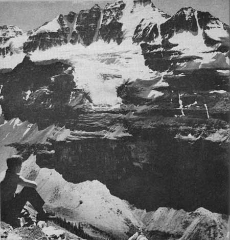
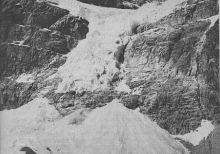 Angel Glacier, on the side of Mount Edith Cavell
in Jasper National Park, issues in this thin tongue from the snowfields
higher up. The fan-shaped deposit below the ice contains boulders and
ground up rock which the glacier has brought down from the eroding
mountains above mixed with snow and ice debris from the wastage of the
glacier itself. Pictures taken 50 years ago show the tongue of ice to
have been several times as wide as it is now and reaching well down
below its present level. The light coloured scar on the rocks shows its
former approximate outline. © D. M. Baird, 1963
Angel Glacier, on the side of Mount Edith Cavell
in Jasper National Park, issues in this thin tongue from the snowfields
higher up. The fan-shaped deposit below the ice contains boulders and
ground up rock which the glacier has brought down from the eroding
mountains above mixed with snow and ice debris from the wastage of the
glacier itself. Pictures taken 50 years ago show the tongue of ice to
have been several times as wide as it is now and reaching well down
below its present level. The light coloured scar on the rocks shows its
former approximate outline. © D. M. Baird, 1963
|
This, the important event in our scenic history, began perhaps a million years ago—no one knows exactly—but it seems to have been about that long ago. Now a million years seems like a long time to those who are not accustomed to thinking in terms of geological time or the time which has elapsed since the earth first took the independent shape it now has. At this moment we will only say that physicists, astronomers and geologists, all working from different viewpoints, generally agree that the earth is something like four to five thousands of millions of years old. Thus the geologists who say that the glacial age began about one million years ago are talking of something recent, speaking in terms of earth history.
An Icecap is Formed
About a million years ago, then, the climate in part of the world, including all of northern North America, began to get cooler very gradually. The winters became a little longer and the summers were not quite as warm as they used to be. Snow which fell in winter began to stay on the ground longer and longer each spring and it came a little earlier each fall. The climate continued to get colder. Eventually the snow stayed all year round in some sheltered spots such as steep valleys and on the north slopes of hills away from the sun. Finally, the temperature rarely went above freezing even in mid-summer, and the snow stayed on the ground, everywhere, all year.
As the seasons went by the snow continued to get deeper, at first tens of feet, then hundreds of feet. When it reached this great thickness the weight of the upper layers of snow on the lower layers caused the bottom snow to change to ice in the same way that snowballs are made by squeezing. As the great blanket got to be thousands of feet thick, the enormous weight of the upper layers squeezed the bottom icelayers so that they began to flow outward from the higher parts of the land, where accumulation was greatest, towards the edges and the sea. Finally, the whole northern part of North America, including almost all of what is now Canada and some of the northern United States, was covered with a great icecap with the snow accumulating on top, getting covered by more and more snow, and turning to ice by the pressure of its own weight. The lower layers flowed out over the country, either to the sea, where it melted or broke off and drifted away, or to warmer parts where it gradually wasted.
Just why this general refrigeration of the world should have taken place no one knows for sure. It may be that the temperature of the surface of the earth was greatly changed by variations in the sun's radiation, either because of changes in the sun itself or because of unusual amounts of volcanic dust in the air. Changes in the amount of carbon dioxide in the atmosphere may also have altered its ability to transmit the sun's heat to the earth's surface. Whatever the cause, there is no doubt that it did take place.
For many thousands of years northern North America lay beneath the icecap, an unbroken wintry scene just like that which we so often see pictured in Antarctica today. But eventually the cycle of climatic change, which brought the cold in the first place, began to swing back and the climate began to get warmer. Over the centuries the icecap began to lose a little more of its volume by melting than it gained by fresh
What the Icecap Did
The great mass of ice pushing over the face of the earth scraped everything loose before it. Soils were torn up and carried away. Great blocks of solid rock were plucked from the earth and carried off, sometimes for many miles. The bedrock was scraped clean and polished by the moving ice which was armed with boulders and debris frozen into it. Hills were rounded off and old river valleys were scoured out and steepened. Where the ice came down to the sea it scooped and wore away the inlets, deepening some, straightening others, and making new ones where there had been none before.
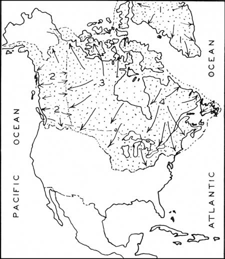 This outline map of North America shows the extent
of the great icecap which covered all of Canada and some parts of the
northern United States. The accumulation of snow was such that the ice
formed from it moved in the directions shown by the arrows from four
major centres. Greenland, (1) had a small icecap of its own which
radiated generally outward from the central ridge. The western
mountains, (2) were glaciated by a complex of mountain glaciers which
flowed westward to the sea, and eastward to meet the ice from a centre,
(3) which lay to the west of Hudson Bay. Another major centre (4) lay to
the east of Hudson Bay. One can see from this map that the scenery of
all of Canada was modified by the coming of the ice, its scraping over
the country and its leaving behind of an irregular blanket of
debris. © G.S.C., Econ. Geol. Series 1, 1947, p. 326, 1963
This outline map of North America shows the extent
of the great icecap which covered all of Canada and some parts of the
northern United States. The accumulation of snow was such that the ice
formed from it moved in the directions shown by the arrows from four
major centres. Greenland, (1) had a small icecap of its own which
radiated generally outward from the central ridge. The western
mountains, (2) were glaciated by a complex of mountain glaciers which
flowed westward to the sea, and eastward to meet the ice from a centre,
(3) which lay to the west of Hudson Bay. Another major centre (4) lay to
the east of Hudson Bay. One can see from this map that the scenery of
all of Canada was modified by the coming of the ice, its scraping over
the country and its leaving behind of an irregular blanket of
debris. © G.S.C., Econ. Geol. Series 1, 1947, p. 326, 1963
|
As the ice melted, the materials it was carrying were deposited in a scattered manner all over the country. Big boulders were left stranded on the hills. Piles of ground-up rocks and old soil were dumped here and there. Some of the debris was washed by the meltwaters into the valleys, but the hills were generally left naked.
When the ice had first come, all the plants and animals were forced to move southward to warmer parts. Some of them, however, were not able to adjust themselves and perished. After the ice had melted, trees seeded themselves back over our land and tried to get a foothold on the bare hills and stony soils, succeeding in many places but finding it impossible where there was only rock.
This is quite a story and until now we have offered no evidence to prove it. The simplest and most logical thing to do first would be to compare what we have said with what we can see now in regions where glaciers of the same kind are still active. For this we have to go either to Antarctica, far northern regions or to almost any of the very high mountain ranges of the world.
Two Kinds of Glaciers
At first glance, glaciers of today seem to be of two distinct types, ones which are confined to valleys in mountainous regions, called Alpine or valley glaciers, and those of very large spread, icecap or continental types. We find on closer inspection, however, that there is no real dividing line, for icecaps commonly reach the sea through glacial tongues in valleys which are really the same as valley glaciers and the latter sometimes join together to form ice sheets. They all, however, have two parts in common, an accumulating area or snowfield and a wasting area where solid glacial ice is melting or floating away. Perhaps high in the mountains snow is accumulating without melting. As the mass of tiny crystals gradually accumulates, the ice on the bottom becomes plastic and begins to squeeze out from under and overflows down valleys. If the lower regions are warmer than the snowfield areas, melting may overtake the ice and the glacier will disappear as a stream of cold water.
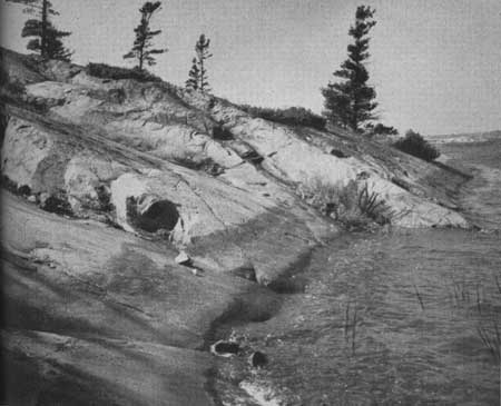
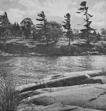 Ten thousand years after the great icecap that once covered Canada
melted the polished, scratched, and rounded rock surfaces show clear
evidence of its passing. Here in St. Lawrence Islands National Park the
pattern of the rock surfaces, the water, and the pines make an
interesting study of arrested motion. © D. M. Baird, 1963
Ten thousand years after the great icecap that once covered Canada
melted the polished, scratched, and rounded rock surfaces show clear
evidence of its passing. Here in St. Lawrence Islands National Park the
pattern of the rock surfaces, the water, and the pines make an
interesting study of arrested motion. © D. M. Baird, 1963
|
Icebergs
If the ice meets the sea, portions of it may break off and form icebergs. Most of the icebergs which come drifting down to the north and east coasts of Newfoundland each spring and summer are actually pieces of the Greenland icecap which reaches the sea in numerous valley tongues. As the ice pushes into the sea it is broken off by its own buoyancy and the pieces move slowly southward in the Labrador Current. Thus these icebergs began as snow, which fell in the interior of Greenland, perhaps hundreds of years ago, gradually turned to massive ice and then flowed down to the sea. This history explains why they are not salty, as any fisherman knows who has had a drink of the delicious, cool meltwater which comes off them in summer. Flat, tabular icebergs of great size break off the part of the icecap in Antarctica that is formed directly on the sea.
The kinds of ice in northern and southern icebergs are different, for the Antarctic ice is a little lighter because of its origin on the sea and is clean because it formed away from the rocks. The Greenland bergs, on the other hand, pushed down narrow valleys and squeezed out through rocky canyons, with the result that they are often contaminated with bits of rock and earthy debris, particularly on their bottoms. After they crack off and move slowly southward, the upper part in the sunlight melts and some of the submerged parts too. It is therefore common for the shape to change and, when this happens, the berg may eventually roll over and float in another position, perhaps revealing its load of rocks. This is a magnificent sight on a clear summer day with the dazzling white berg slowly rolling over on a blue sea and the seawater pouring off it in a thousand cascades. Occasionally they split in two with a roar like heavy gunfire. In summer icebergs are common in the sea off Terra Nova Park and you may actually see one turn over and split in two.
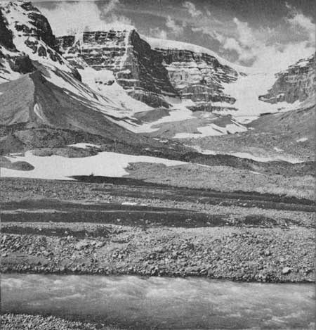 Dome Glacier in the right background comes from
the refreezing of masses of ice and snow which tumble over the cliffs
from the edge of the Columbia Icefield along the skyline. This
"reconstituted" glacier was once much larger than it is now and filled
the whole valley pushing up the sharp edged wall of debris in the left
portion of the photograph. The swift flowing stream in the foreground
is mostly meltwater from the Athabasca Glacier and the mass of boulders
and rock rubble has come largely as outwash from the melting ice. You
can see that the rocks of which the mountain bowl is made are flat lying
from the way the snow lies on the ledges made by the bedding. © D. M. Baird, 1963
Dome Glacier in the right background comes from
the refreezing of masses of ice and snow which tumble over the cliffs
from the edge of the Columbia Icefield along the skyline. This
"reconstituted" glacier was once much larger than it is now and filled
the whole valley pushing up the sharp edged wall of debris in the left
portion of the photograph. The swift flowing stream in the foreground
is mostly meltwater from the Athabasca Glacier and the mass of boulders
and rock rubble has come largely as outwash from the melting ice. You
can see that the rocks of which the mountain bowl is made are flat lying
from the way the snow lies on the ledges made by the bedding. © D. M. Baird, 1963
|
The glaciers which squeeze out of the Greenland valleys to the sea really represent the drainage of an area which is unable to rid itself in any other way of the precipitation which falls on it. Glaciers of this kind are thus truly "rivers of ice".
How Glaciers Flow
All along we have been referring to the "flow" of glaciers and have not yet remarked on the fact that ice, a solid, should be able to "flow" and thus carry precipitation from one area downhill to another. In earlier times when people had not begun to study them in detail, glaciers were looked upon as solid, inert masses of ice. Systematic studies, begun about 150 years ago, however, soon showed that ice in Alpine glaciers indeed moves, and, further, that it moves in much the way that river water moves. One of the earliest and simplest of experiments was the placing of a number of stakes or distinctively marked stones on the surface of a glacier. They were carefully surveyed from stations on the solid rock of the valley wall and then at intervals they were surveyed again. The change of position of the markers was a simple yet effective measure of the movement of the glacial ice.
The centre of the ice usually flows faster than the edges because of friction along the sides. The upper part flows faster than the bottom because of friction there. We know that valley glaciers have tributaries and that the whole glacier system looks like a river system. We know that irregularities in the bottom may cause the glacial ice to stretch and even break to form crevasses or open splits which climbers dread. In some places where the bed of the glacier valley becomes a great deal steeper in a short distance the glacier ice may split and break up into lumps which make the great icefalls familiar to all who have read of the climbing expeditions in such places as the Himalayas. Ice-falls may be seen on a modest scale in Canada's western parks at several places.
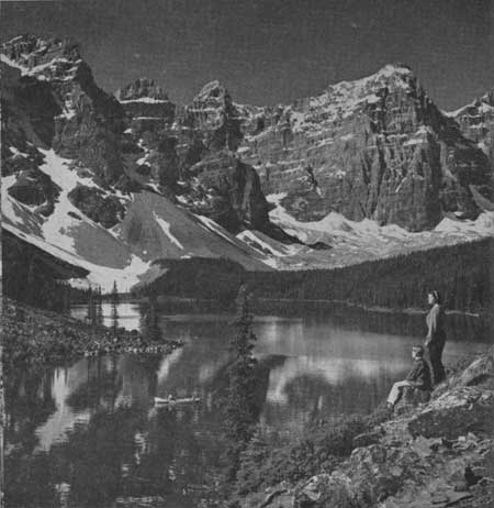 Glaciers and rivers carved these beautiful
mountains from a great mass of rocks which was earlier uplifted by
enormous forces within the earth. Here, in Banff National Park, Moraine
Lake lies in a rocky bowl which is slowly wasting away to produce the
talus slopes which you can see sloping down from the cliffs. The hollow,
which holds the lake, was made by glaciers which scooped out the basin
and partly dammed it up with masses of clay, sand and bouldery
gravel. © Canadian Government Travel Bureau, 1963
Glaciers and rivers carved these beautiful
mountains from a great mass of rocks which was earlier uplifted by
enormous forces within the earth. Here, in Banff National Park, Moraine
Lake lies in a rocky bowl which is slowly wasting away to produce the
talus slopes which you can see sloping down from the cliffs. The hollow,
which holds the lake, was made by glaciers which scooped out the basin
and partly dammed it up with masses of clay, sand and bouldery
gravel. © Canadian Government Travel Bureau, 1963
|
Not only does glacial ice flow at different rates within the same glacier but from glacier to glacier the rates differ even as in rivers, and in the same glaciers the rates may differ from year to year. One would expect that a very large snowfield with a small outlet would require a faster-flowing glacier to carry away the precipitation than a smaller snowfield with a larger outlet.
The fastest-moving glaciers, perhaps those of the margins of the Greenland icecap, may move forward 80 feet a day or about five miles a year. Moderate-sized glaciers in the Alps and other mountain regions, where snow-gathering areas are not so large in proportion to outlets, may move as slowly as 100 feet a year or as fast as 600 feet a year. Some of the huge glaciers of central Asia may reach a half-mile a year. Athabasca Glacier in Jasper National Park averages a little more than 50 feet a year.
We still have not answered the question as to how the seemingly solid glaciers 'flow'. Ice is fairly plastic near and at the melting point. This is brought about by what is known as translation-gliding in which crystals of ice are able to shear along certain directions and not come apart, or "lose mechanical cohesion", as the experts would say. Thus, under pressure of overlying or up-hill ice, the individual grains of ice are able to divide into parallel slices and these move microscopic distances past one another without the ice losing its solid structure. When all the millions of little crystals in a glacier do this the ice seems to flow forward.
Another property of ice that helps it flow like a thick liquid is its quick refreezability. If movement is such that the ice actually breaks, on a big or little scale, the broken pieces quickly freeze again into a solid mass. Both these processes are on a scale we cannot see but when they occur in millions of grains of ice in a glacier they combine to make a "plastic flow" which is visible.
The Effects of Moving Ice
This movement of ice down narrow valleys or over broader areas has a profound effect upon the ground or the rocks underneath. The pushing forward of a wall of ice many feet high acts like a snowplough, until the pile of material in front gets too much to push so the ice rides up over the top of it, carrying with it as much as it can carry and leaving what it cannot.
Wherever the ice stops, this ploughed up material will be left as a ridge to mark the farthest penetration. The fronts of glaciers all over the world are marked by these front ridges or terminal moraines. Vast terminal moraines still mark the southern limit of penetration of the great continental glacier which covered Canada and the northern United States. These extend as ragged lines across the northern and north-central States and emerge on the eastern side as ridges which together make up Long Island and Cape Cod.
If the ice were to cross the grain of the country, ridges would be heavily scraped and eroded and valleys filled with glacial rubble. Rock basins would be scoured out and perhaps deepened. Rock surfaces would be scratched by the moving ice and particularly by the boulders and debris frozen into the bottom of it. All these would be left behind as evidence of the passing of the ice. An examination of any part of Canada shows, indeed, that it is a scratched-up country, for on fresh rock outcrops scratches and traces of scour and abrasion are almost universally evident.
 Here, in Georgian Bay Islands National Park, the
waters of Lake Huron wash surfaces of ancient rock which were polished
and smoothed by the movement of the great icecap which covered northern
North America in geologically recent times. In the left foreground, and
again on the farther end, you can see channeling and scratching. You may
also see that wave erosion has made no impression at all on the hard,
resistant rocks. © National Film Board of Canada, 1963
Here, in Georgian Bay Islands National Park, the
waters of Lake Huron wash surfaces of ancient rock which were polished
and smoothed by the movement of the great icecap which covered northern
North America in geologically recent times. In the left foreground, and
again on the farther end, you can see channeling and scratching. You may
also see that wave erosion has made no impression at all on the hard,
resistant rocks. © National Film Board of Canada, 1963
|
After a glacier has passed, irregular deposits of material are to be found dumped over the country as a general cover. If you look at road cuts in many parts of Canada you will see a mixture of boulders, partly rounded and partly faceted, scratched and of various kinds, mixed with sand and rock flour, without any sign of water action. This is called glacial till. With the melting of the ice a great deal of debris, already dropped and overridden by the ice and also coming free as the ice melts will be picked up by the melting water, carried a short distance and then dropped again. The short ride in water, however, is enough to wash out the finest particles and separate the rest into layers, so that these outwash deposits, as they may collectively be called, are always banded or stratified. These too are very common all over Canada and the northern United States. Some of these water-washed glacial deposits are in the form of small steep hills or kames. Some are in the form of terraces along valley sides and others as a general blanket over the country. They are almost always the source of excellent gravels for road- and railroad-building.
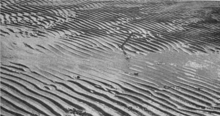
 Ripple marks are commonly formed where waves sweep
in over shallow, sandy bottoms. It sometimes happens that these surface
features are covered by later muds and sands and are preserved
throughout the process of hardening to solid rock. Thus, in some rocky
outcroppings, we can still see the ripple marks which were made hundreds
of millions of years ago by waves of seas which have long since
disappeared. © D. M. Baird, 1963
Ripple marks are commonly formed where waves sweep
in over shallow, sandy bottoms. It sometimes happens that these surface
features are covered by later muds and sands and are preserved
throughout the process of hardening to solid rock. Thus, in some rocky
outcroppings, we can still see the ripple marks which were made hundreds
of millions of years ago by waves of seas which have long since
disappeared. © D. M. Baird, 1963
|
Now we have come to know that Canada was once covered by an enormous icecap that scraped and scoured the country, filled in old valleys and dug out rocky basins, and left the country covered with an irregular blanket of glacial debris. We also know that we have only to go to Greenland, Antarctica, or high mountain regions to see the same processes at work today.
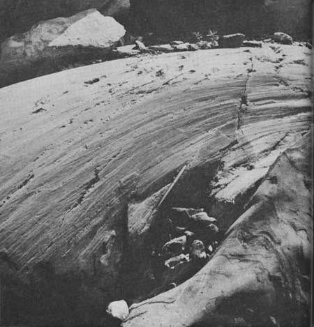
 Moving glacial ice scratches and channels rocks to produce surfaces
like this one on the side of Grand Glacier in Glacier National Park.
Now, after the ice has melted away from this spot, the scratched and
polished surface shows clearly the direction of movement of the ice. © D. M. Baird, 1963
Moving glacial ice scratches and channels rocks to produce surfaces
like this one on the side of Grand Glacier in Glacier National Park.
Now, after the ice has melted away from this spot, the scratched and
polished surface shows clearly the direction of movement of the ice. © D. M. Baird, 1963
|
Where Did Our Icecap Begin?
Before we leave glaciers let us examine a few other questions about them and their effects on the scenery. Where, for example, did the snows accumulate or, put another way, where did the ice come from? By putting all the evidence together things like the directions of scratches on the rocks, and tracing stranded boulders back to their places of origin geologists can see clearly that four major centres of snow and ice accumulation accounted for our glacial age. One was situated in the Ungava Peninsula just east of Hudson Bay, and another was situated west of the main body of Hudson Bay. The ice from these two centres joined together and covered all of Canada from the western mountains to the Atlantic, and the United States north of the Missouri and Ohio Rivers, and eastward to Long Island. The western mountains supported another icecap made up of the coalescing of what started as many individual ice fields. It eventually flowed off the mountains to the sea on the west, and eastward to join the other ice just mentioned. Remnants of this mass of ice are still to be found in the high mountains. The largest is the Columbia Ice-field, which is shared by Banff and Jasper Parks. It is interesting to note that its meltwaters pass into three oceans: through the Saskatchewan to Hudson Bay and the Atlantic; through the Athabasca to the Arctic; and through the Fraser and Columbia Rivers to the Pacific.
Great Glacial Lakes
Can you imagine what must have happened when the ice was retreating northward as the climate gradually warmed up? The southern edge of the ice must have slowly retreated northward, uncovering the country back towards the sources of supply. In Canada this process led to the formation of many large lakes as valleys and lowlands were uncovered while their outlets were still blocked either by ice or by glacial deposits. Thus one enormous lake, called, in retrospect, Lake Agassiz and larger than the combined areas of all the Great Lakes, was formed over what is now southern Manitoba and adjacent areas. Into this great lake, rivers and meltwater streams poured mud and silt which settled to blanket the bottom. After the glaciers retreated still farther, outlets to the north were uncovered and the lake gradually shrank. Lakes Winnipeg, Manitoba and Winnipegosis are remnants of it. The sediments laid down in this largely vanished lake are now the rich soils which cover much of southern Manitoba and make it one of the finest wheat-growing areas in the world.
Another of the very large lakes of this time was one which lay astride the Ontario-Quebec boundary in the latitude of Cochrane and Amos. Remnants of this one are to be found in Lakes Timiskaming and Abitibi and its passing is marked for us by the clay soils which cover several thousand square miles in that area.
Rivers and Lakes
After the glacial ice melted away the general shape of the topography had not altered very much but in detail the surface was entirely different. When the country was once again left open to ordinary climatic events, rivers tried to resume flow where they used to, but often found their old valleys blocked in places with glacial debris. Some parts of their valleys were entirely filled, but others were hardly touched. Rock basins and depressions made by glacial dams now collected water which overflowed and spilled out where it could. The result was a completely disrupted drainage pattern with only the broad outlines of the pre-glacial drainage left. Rivers wandered from lake to lake, partly in old, well-established valleys, partly in new courses which could only be described as haphazard. The drainage in some places was so erratic and so dammed-up in depressions that as much as 60 percent of the area became lake and swamp. Ever since this happened streams have been seeking to establish equilibrium again by cutting down the outlets of lakes, removing obstructions that make waterfalls and rapids, straightening out erratic courses. Thus, visitors to the Muskoka Lakes, or those in the Laurentians north of Montreal, on lakes in Nova Scotia or in Prince Albert National Park all owe the beauty of the lake scenery to the cold, white ice of thousands of years ago that dammed up streams, pushed them out of their valleys and scraped out rocky basins.
 A hiker pauses to look across a great chasm
towards Mount Stanley in Kootenay National Park. The snow patches among
the peaks and the small glacier clinging to the side are the shrunken
remnants of a great tongue of ice which carved the steep valley and made
the enormous cliffs in the lower part of the rock wall opposite. © D. M. Baird, 1963
A hiker pauses to look across a great chasm
towards Mount Stanley in Kootenay National Park. The snow patches among
the peaks and the small glacier clinging to the side are the shrunken
remnants of a great tongue of ice which carved the steep valley and made
the enormous cliffs in the lower part of the rock wall opposite. © D. M. Baird, 1963
|
Hydro-electric power developments are usually dependent on glacial history too, because it is in the glacial lakes that water is stored, and the falls that the power-plants are built on were formed where disrupted rivers fall over the sides of old valleys or off the edges of plateaus where they would not have ventured if the glaciers had not long ago changed their courses for them.
Great Lakes and the St. Lawrence
One cannot avoid talking of the Great Lakes and the St. Lawrence River when one looks into the effects of the glacial age in North America, for these enormous bodies of fresh water are direct results of the Ice Age. Prior to the amassing of an icecap, that part of North America consisted of a number of basins and valleys with drainage variously to the south and east. When the glaciers moved down over the land these basins were dug out and deepened and great piles of debris placed to the south of them. In addition, the crust of the earth in that region was actually bent downwards by the weight of the great mass of ice.
When the glacial ice had melted back to uncover the area, the basins were no longer able to drain themselves by the old routes, so filled up and found their drainage where they could. We know that at first this was different for old shorelines show that the lakes were much larger then, and we see evidence of rivers draining from Superior and Michigan southward to the Mississippi system, and from the others by various routes eastward to the Hudson River. The present topography took shape after a complicated history of alterations, as the land gradually came clear of glacial ice and as the whole area gradually came up again after the weight of the ice was removed. One of the new outlet rivers found itself flowing over a limestone cliff and formed the ancestor of Niagara Falls. During the thousands of years since then the falls have cut back to their present position, leaving behind the great gorge to mark their passing.
Summary
Glaciers are active now in all the high mountains, for even on the equator, if mountains are high enough, permanent ice is to be found modifying the scenery. Even now as we are reading about it, plastic ice is squeezing down the Greenland valleys, and giving birth to this year's crop of icebergs in the Atlantic. Rocks are being scratched, boulders are being lifted from the bedrock and carried off, piles of rock, sand and clay are being dumped at the ends of glaciers. The mountains of Antarctica are being heavily abraded by moving ice.
As we pause to look at a mountain glacier in Western Canada or polished and scratched rock surfaces in the east we must remember that we have no guarantee that the climate will continue to be as warm as it is now. Perhaps, once again, gradual refrigeration of the world climate will set in and once again an icecap will come scraping and creeping down from the north to cover all. Let us be very patient, however, for we may have to wait several thousand years to find out.
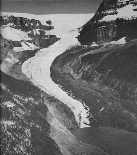 Columbia Glacier spills over from the Columbia Icefield, along the
top margin of the picture, to push down the valley where melting finally
overtakes it. Its sides are deeply covered in rock rubble which was mounded up into the steep
lateral moraines at a time when the glacier was much larger than it
is today. © D. M. Baird, 1963
Columbia Glacier spills over from the Columbia Icefield, along the
top margin of the picture, to push down the valley where melting finally
overtakes it. Its sides are deeply covered in rock rubble which was mounded up into the steep
lateral moraines at a time when the glacier was much larger than it
is today. © D. M. Baird, 1963
|