for Visitors in Canada's National Parks
LAKES
We have just been discussing the origin of islands which are bodies of land entirely surrounded by water. Let us turn to lakes for a moment, to think of them as bodies of water entirely surrounded by land, to see how they originate. We pay a lot of attention to lakes because of their scenic beauty, their use to mankind as sources of water for domestic and industrial use, their function as reservoirs for hydroelectric developments and flood control, and even for their good fishing.
Glacial Lakes
Most lakes in the world have come from the disruption of normal drainage systems by glaciation. You may recall from our section on glaciers and how they work that, when icecaps or glaciers on a large scale scrape over the country in times of general refrigeration of the climate, soil and loose rocks are picked up and carried off by the ice to be dropped again when the load gets too big or when the ice melts. Shallow rock basins may be scooped out and valleys may be much modified. When the ice age is over after the climate warms up again, rivers may find the major outlines of the country unchanged but the details very different. Valleys may be blocked off in some places and rivers forced out of their channels. Water collects in all the places that accidents of glacial deposition have left hollows and lakes are formed.
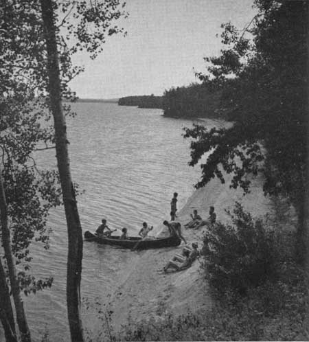 Beach scenes on lakes, like this one at Lake
Waskesiu, Prince Albert National Park, Saskatchewan, are found in many
parts of Canada. The lake was made by the glaciers which once covered
the area, scraping away the old soils, damming up the old river systems
and spreading sands and gravels widely over the region. Waves from the
lake have washed the sand clean and piled it up into ridges along the
beach.
Beach scenes on lakes, like this one at Lake
Waskesiu, Prince Albert National Park, Saskatchewan, are found in many
parts of Canada. The lake was made by the glaciers which once covered
the area, scraping away the old soils, damming up the old river systems
and spreading sands and gravels widely over the region. Waves from the
lake have washed the sand clean and piled it up into ridges along the
beach.
|
Hundreds of thousands of such lakes dot the surface of Canada. In some areas as much as 60 percent of the whole surface consists of lakes. They vary from small puddles to giants like Lake Superior which has an area of 40,000 square miles and is the largest body of fresh water in the world. They may be a thousand feet deep or they may be little more than shallowly flooded boulder fields. They may be about the same size and shape as when they were first formed, or they may be largely drained, either because of the opening of new outlets or because their outlets have been cut down below their original levels by stream erosion. We have already mentioned that vast glacial lakes were formed when the ice was retreating in the face of a warming climate and water was trapped between higher lands to the south and the ice front on the north. When the ice withdrew still farther north outlets were opened up which largely drained the Lakes. Nowadays we look at Lake Winnipeg, Lake Winnipegosis and the complex of adjacent lakes as the remnant of a much larger lake formed in this way. Old shorelines and beaches can be clearly seen many miles away from the present lake waters. The Great Lakes were much larger at one time than they are now and old beaches, beach bars and even islands are now high and dry, miles from the shoreline.
Some of the most beautiful of all glacial lakes are the small ones called tarns which nestle in "cirques" or glacially carved bowls in mountain regions. As moving ice scoops out the bowl-like cirques the waste is piled up somewhere below. It often happens that small depressions within the glacial bowls are filled with water when the glaciers retreat or disappear. These are often very beautiful with their settings in rocky bowls, almost surrounded by great cliffs, and snowfields or even glaciers above them to reflect in their waters.
Lakes Made by Landslides and Lava Flows
Rivers are occasionally dammed by landslides and lava flows to form lakes. Their size would depend on what shape the river valley is and how big a dam was made. One which was formed by a giant landslide in central Asia, is 45 miles long and 1,650 feet deep. Earthquake Lake was formed in the valley of the Madison River in Montana in August, 1959, when an earthquake set off a landslide which made a dam of rock rubble 200 to 400 feet deep. Mudslides in smaller streams on the other hand may raise the water level only a few inches and be entirely worn away in a few days. Lava flows rarely make dams in stream valleys.
Lakes Made by River Erosion
When streams flow on flat surfaces they often have very crooked and winding courses. If a looping bend or meander in a river gets tight enough the river may cut through the narrow neck of land and by-pass the loop. The two ends of the cutoff may be rapidly silted up by the main river, leaving what is called an oxbow lake. The courses of many rivers are studded with oxbow lakes.
Lakes by Interior Drainage
It occasionally happens that sections of the earth's surface are made lower than their surroundings as a result of great earth stresses which cause some areas to fold or to sink downward because their supports are removed. In some limited areas depressions may be caused by wind erosion or irregular distribution of glacial deposits. If there should be precipitation in such an area, the waters would run towards the centre of the basin and a lake would be formed. If there is enough precipitation in the area to fill the depression the water will rise until an outlet is found and a normal drainage system established for the lake.
In some areas, however, precipitation can only fill the depression partway before evaporation or seepage through the ground keeps up with the inflow of water. Since all rivers carry some salts in solution in their waters, evaporation in lakes with no outlets will leave the salts behind to form salt lakes. The Dead Sea, the Caspian Sea, Salt Lake in Utah and hundreds of small salt lakes in southern Saskatchewan and Alberta are formed this way.
Man-made Lakes
In many parts of the world the only lakes are man-made. Streams and rivers are dammed with earth, wood, concrete and steel for hydro-electric power installations, flood control, domestic water reservoirs and a great variety of other purposes.
The shapes of such man-made lakes are usually distinctive because they are usually water-filled valleys. The lakes thus formed are elongated parallel to the main river course, wider at the dam end than on the upper end, and they usually have arms which are the flooded valleys of tributary streams.
Animal-made Lakes
Small lakes are made by beavers in many parts of Canada by damming streams with sticks and mud. Some of these cover several acres and it is usual for several to be found in a series along a stream course. As the water spreads into the woods on the sides of a dammed brook the trees usually die off leaving a stub filled and rather unattractive pond or lake. If the animals are killed off or the site abandoned for any other reason it is usual for the dam to be breached quickly and the lake drained.
Volcanic and Structural Lakes
Lakes are sometimes formed in the craters of inactive volcanoes or in pits which are formed when old volcanoes collapse. Such a lake is Crater Lake in Oregon and several of this kind are known in Mexico. Small lakes are also formed when basins are formed by the subsidence of small areas because of structural weaknesses of the earth.
Sink Lakes
Limestone, gypsum and salt are materials which occur in normal sedimentary rocks in many parts of the world. These are all very soluble in ordinary underground water. If, over a period of time, large openings or caves are dissolved out of such rocks near the surface, they may be unable to support their roofs and collapse. Some of these sinks then fill with water to make small ponds and lakes. Several areas in Nova Scotia, Newfoundland and New Brunswick are pitted with sinks and sink lakes, as are some sections of northern Alberta and the western mountains. Some of these occur just outside the boundaries of Cape Breton Highlands Park.
Conclusion
Lakes are formed in many ways by damming of the natural flow of water on or near the surface of the earth. They are all temporary, however, for the outlets are constantly being cut down to drain them, silts settle out of the quiet waters to fill in the basins and vegetation spreads out from the shores to cover them.