for Visitors in Canada's National Parks
RIVERS
Rivers have played an important part in man's history from its very beginnings. His early villages were placed on river banks and he found it most convenient to use them as highways from place to place. He still places his cities on or near rivers and he still uses them extensively as routes of transportation. The history of exploration of most countries begins with stories of penetration of the interior along rivers.
Canadian history is dominated as much as that of any country by its rivers. The great St. Lawrence River system has been a main highway since the earliest quest for a northwest passage to China, and still is today, with the development of the new seaway into the heartland of North America. The names of early heroes come down to us in romantic succession as we think of the rivers of our country—Jacques Cartier in the St. Lawrence; Champlain at the mouths of the St. Croix, the Saint John, and the Annapolis before 1610; La Verendrye westward from Superior to the Assiniboine and Souris; Henday to the Saskatchewans; Samuel Hearne west and north to the Coppermine: Peter Pond and Alexander Mackenzie northward to the Arctic on the Mackenzie River, and later Mackenzie to the sea on the Peace and its tributaries.
Rivers and Valleys
We have been looking at and using rivers for a very long time. Yet it is only since about the end of the 18th century that we have enquired into their origin and their development. It was about then that people began to realize that river valleys are the result of the slow but steady cutting of the land by the rivers which occupy those valleys. The spread of this understanding started with an obscure book written and published by James Hutton, a scientific pioneer who developed his ideas while walking the shores and moorlands of Scotland. His admirer and friend, John Playfair, rewrote in a more readable form the monumental but dull work that Hutton had left, and published it in 1802. From that time to this we have looked to the processes which are operating now for the explanation of features of the landscape which we see around us. Here is an extract on the subject of rivers from Playfair's exposition of the Huttonian view. While we read it let us listen to the lovely old language which is now so rare in scientific writing.
|
"If indeed a river consisted of a single stream, without branches, running in a straight valley, it might be supposed that some great concussion, or some powerful torrent, had opened at once the channel by which its waters are conducted to the ocean; but when the usual form of a river is considered, the trunk divided into many branches which rise a great distance from one another, and these again subdivided into an infinity of smaller ramifications, it becomes strongly impressed upon the mind that all these channels have been cut by the waters themselves; that they have been slowly dug out by the washing and erosion of the land; and that it is by the repeated touches of the same instrument that this curious assemblage of lines has been engraved so deeply on the surface of the globe." |
Once this idea became accepted it meant that rivers could be investigated in the sense that they are orderly and that they have a system of development.
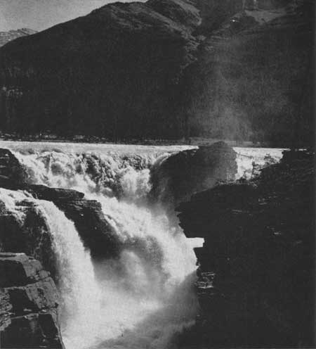 Mount Kerkeslin looms darkly in the background as the waters plunge
wildly over Athabasca Falls into the steep-walled gorge below.
Waterfalls like this one in Jasper National Park are typical of either
youthful streams or of regions in which the normal drainage has been
disrupted by glacial erosion and deposition. © Canadian Government Travel Bureau, 1963
Mount Kerkeslin looms darkly in the background as the waters plunge
wildly over Athabasca Falls into the steep-walled gorge below.
Waterfalls like this one in Jasper National Park are typical of either
youthful streams or of regions in which the normal drainage has been
disrupted by glacial erosion and deposition. © Canadian Government Travel Bureau, 1963
|
Amount of Water in Rivers
We have already seen that the water which falls on the surface of the earth may evaporate, become immobile in plants and minerals, sink into the earth to become part of the underground water system, or form part of the runoff in rivers and lakes. Water destined for the runoff system may fall directly into a river or a lake and begin at one its journey back to the sea, or it may fall on other surfaces and take a short time to get into the flow of things.
Some of the water which sinks underground comes out at the surface again and becomes part of the runoff. In some areas, in fact, it is only this supply of water which keeps rivers and streams going in times of drought. Since the pores and openings in rocks and soils are very small the water moves very slowly through them. This means that rainwater may reach the rivers a long time after it first arrives on the ground. This lag is what evens out the flow of rivers in many areas.
The matter of the volume of water in any one river and its distribution during the year is an important one. In most parts of Canada our rivers fall low during the summer, rise in late summer or autumn rains, slacken off again in winter when the precipitation stays immobilized on the ground as snow and ice, then rise sharply to their seasonal high in a springtime of rapidly melting snow. In our western mountain streams this rhythm may be altered when the snow on lower levels makes for a spring rise and then, all summer long, the snowfields, higher and higher and farther and farther back in the mountains, continue to keep the streams well supplied with water.
Visitors to the mountain parks in Western Canada in summer may note that the early morning sees a low water level in streams and that they will have to wait until past noon for the rise which comes from the increasing melt water from the morning sun. Correspondingly the tapering off of the daily increase may not take place until well after nightfall.
An interesting river in respect to its volume is the Rhine, for it rises in several different kinds of places. One set of head-waters is dominated by glacier meltwaters. These pour forth their maximum in the heat of summer. Another contributor rises in lower mountains which give their snowy melt waters in the spring, and reach a low in summer. Still a third part of its reservoir comes from a warmer lowland area where winters are marked principally by heavy rains, thus adding a load to the Rhine at exactly the minimum season of other parts of the system. The result is that the Rhine, in its lower reaches, is remarkably constant in its volume of water which comes from different places at different times.
Lakes in the courses of rivers make natural regulators of the flow by absorbing sudden increases in volume of flow and feeding it more slowly and evenly to the lower river again. Thus in almost all Canadian waterways lakes even out the spring freshets or floods. Man has emphasized the role of the lakes in many places by adding dams, with which he can further even out the flow, so that he will have a steady supply for his hydro-electric stations or for his irrigation and other projects. In some places the dams are put up for the specific purpose of preventing sudden runoffs which we call floods. The Mississippi River is getting gradually more and more under control in this respect as more and more dams hold back the sudden rush of water, particularly in tributary basins. The South Saskatchewan Dam will similarly even out the flow in that great river, as will storage dams on the Columbia.
In some areas of the world the runoff is much affected by evaporation. Evaporation takes place wherever water is exposed to the air. Surfaces of lakes and rivers, and of the sea, are always providing water-vapour to the atmosphere. In basins where evaporation is less than the precipitation some water must run off or sink into the ground, and thus may make rivers. In a few areas, however, the amount of evaporation exceeds the precipitation. Thus some parts of the world are characterized by streams which are temporary because of this. Perhaps rain falling in the mountains starts streams flowing down into dry valleys where eventually evaporation removes all the water. Perhaps a lake is formed in a valley and the water evaporates from the lake surface as fast as the rivers bring it in. Such is the Dead Sea, an inland lake where water from the Jordan River collects and evaporates at about the same rate as it comes in. Lakes like the Dead Sea, the Caspian, the Sea of Aral, Salt Lake, and others gradually become more salty as the rivers keep bringing in small amounts of dissolved materials, which are left behind as the water evaporates. Many lakes in southern Saskatchewan are rich in salts because they have no outlets and evaporation concentrates what is washed into them.
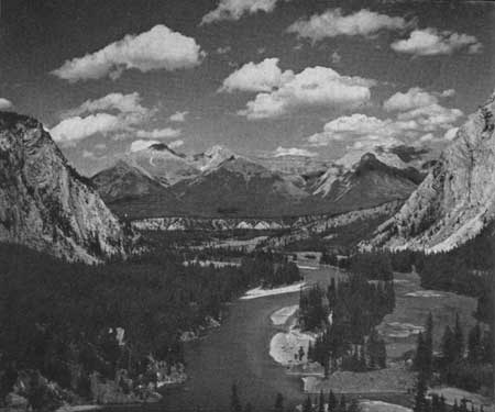 This view of the Bow River, looking toward the
Fairholme Range, is in Banff National Park. The rocks of the distant
mountains seem to be nearly horizontal but these in the foreground
seem to be dipping steeply. The river is making islands and gravel bars
out of the materials of weathering of the mountains all around. The flat
terrace in the middle distance must have been made when erosion was
controlled at a higher level than now, for the present river is cutting
into it. Where park visitors pass restful days the glaciers once slowly
ground their way. © National Film Board of Canada, 1963
This view of the Bow River, looking toward the
Fairholme Range, is in Banff National Park. The rocks of the distant
mountains seem to be nearly horizontal but these in the foreground
seem to be dipping steeply. The river is making islands and gravel bars
out of the materials of weathering of the mountains all around. The flat
terrace in the middle distance must have been made when erosion was
controlled at a higher level than now, for the present river is cutting
into it. Where park visitors pass restful days the glaciers once slowly
ground their way. © National Film Board of Canada, 1963
|
How Rivers Cut and Carry
The salts which are left behind when river water evaporates, deltas where the rivers enter the sea, the cutting into and the falling away of river banks, and muddy waters themselves, all tell us of the cutting and carrying power of rivers. Now let's see how they do it.
When rain falls on the surface it is usually nearly pure water. If the rock or soil the rain falls on contains anything that is soluble, the pure rain water will dissolve it, and when the water reaches the river the dissolved material will be carried on downstream. River waters all carry some dissolved materials.
When mud is stirred up in the water the fine grains will stay suspended in the water for long periods. Thus rivers carry, by suspension, large quantities of materials to the sea. The third method might be called hydraulic action. By this is meant the push of a moving stream of water, the same thing that makes dirt on the street fly when a hose is turned on it. On the river bottom small grains of sand and pebbles are pushed and rolled along by the force of the water itself. In rivers which flow very fast the hydraulic action is powerful enough to move great boulders as can be seen in many of the mountain streams in Canada's Parks.
These same processes help add to the river's load of material being carried to the sea by wearing into the bank or dissolving soluble materials from it. They are joined, however, by another process called abrasion. As it bumps along the bottom, a large boulder cannot help but loosen and knock off other fragments which then become part of the river's load. Even small sand grains knocking against rocks may grind them down and the ground-up rock then joins the river's load on its way to the sea.
These several processes together contribute the load to the moving water. Whether or not they will be effective and thus whether or not a stream has a large load will depend on a variety of things. The faster a stream flows the greater will be its cutting and carrying power. The more turbulent a stream is, the greater its cutting and carrying power. The bigger the amount of the water in the river, the greater the potential load will be. Differences in shape of the channel will affect it, too. The character of the materials being fed to the river will affect the load as will the kind of rocks the river is flowing over. Thus in regions underlain by sandstone, a sandy load would be expected and in regions of soluble limestones the load would be largely in solution.
Deltas
Regardless of how and why the load of the river is carried, the place where it empties into the ocean is bound to see it largely precipitated. There the current of the river is stopped so that most particles in suspension or carried by hydraulic action are deposited. There the salts in the sea precipitate most chemically precipitable materials. And, thus, deltas are born.
Deltas may be of almost any size or shape. The Mississippi River delta is estimated to be at least 30,000 feet thick, and two million tons of solid matter are carried down every day to be added to it. It is scores of miles long and very wide, and really begins miles upstream from the sea-front, for it is by deposition along the channel that the uppermost area of the delta is built up. At the lower end the river has split up into many distributaries which seem to extend themselves out into the sea, building their own little deltas.
Other classic deltas are those of the Nile at the southeast corner of the Mediterranean Sea, the Mahakam on the east coast of Borneo, and the Niger flowing into the Gulf of Guinea. Canada's largest river system, the Mackenzie, has a large delta where it empties into the Arctic Ocean. Unusual "inland deltas" are formed where some of its large tributaries enter the great northern lakes. One of these is being built on the southwest end of Lake Athabasca by the Athabasca River and another on the south shore of Great Slave Lake by the Slave River.
Some rivers have no deltas at all because of emptying into very deep water or into a part of the sea which is swept by such powerful currents that all the river's load is carried off and dispersed, away from the river-mouth. Still others have their deltas in estuaries so that one doesn't notice them. This last kind of river and delta arrangement is common on coastlines which have been submerged in the oceans so that the river valley is flooded part way. Many of the rivers in eastern and western Canada are like this.
Youthful Rivers and Waterfalls
Now we have looked at the origin of rivers in the runoff of precipitation and have seen how they cut and carry materials and what happens when rivers dump their loads. From here let us turn to see what happens to rivers themselves after they begin. New rivers and new parts of rivers, which we call youthful, tend to be fast-flowing and to flow in more or less straight lines. The areas between adjacent rivers tend to be high and wide. The dominant action of such new or youthful rivers is to cut rapidly downwards into the rocks below. This results in steep-sided valleys and streams which fill the width of the valley bottoms. Because rivers in this early stage of development are cutting rapidly downwards into their rocky beds, it is very common to find waterfalls and rapids in them, marking places where especially resistant rocklayers protrude. These interruptions in down-cutting generally mean that the rivers are slowed above them, then run rapidly or even fall over them, to be slowed again below them. The Lachine Rapids in the mighty St. Lawrence mark the head of unassisted navigation because resistant dike rocks cut into and support the limestones of the district. What a profound effect on Canadian history this interruption in the down-cutting of the St. Lawrence River has had, for without it, it is unlikely that Montreal would have grown where it did.
Western rivers are full of rapids and waterfalls. Some of these are spectacular, sheer drops and others, like the canyon of the Fraser, are stretches of wild rapids. Niagara Falls, on the other hand, is where a comparatively new river crosses layers of rock of different hardnesses which lie athwart its path and dip gently upstream, rather the same as water flowing down a shingled roof. One of these layers is especially massive and resistant but is underlain by another which is much less resistant. The softer layer gets rapidly worn away by the water, thus undercutting the hard one, resulting in the great falls with the canyon below. Not all waterfalls and rapids are the result of interruption in the downward cutting activities in youthful streams for a great many of them originate when rivers are pushed out of their courses by glaciers and flow wherever they can. If they should flow over the side of an old valley, or find their courses blocked with masses of great boulders then falls and rapids may be produced. But this aspect of erosion we will leave for the section on glaciers and their effects.
To get back to the youthful, fast-flowing streams. As rivers cut downward, their slopes or gradients are reduced. As we saw earlier the slope is one of the things that affects the cutting and carrying power of streams. Thus the river is slowed and weakened in its cutting power as it approaches some lower level. What is this level? Ultimately it is sea level, but temporarily it may be a lake level. The river obviously cannot cut below this and it is thus given the term base level. The new stream cuts rapidly downward towards its base level, and when it approaches it, its down-cutting is reduced. Small tributaries and the wash of rain and snow on the valley sides begin to eat away at the shoulders of the valley. This results in the broadening or opening up of the valley. In the valley bottom itself the river begins to wander sideways, back and forth, and gradually begins to cut a level area which it may partially fill with its own deposits.
Mature and Old Age Streams
The beginning of the valley flat marks a new stage in the life of the river which is given the name maturity. As the stream further matures, its tributary system gets more and more well developed until the whole country is covered with a branching network of streams, which are tributary to the one we have our eye on and the similar ones adjacent to it. The whole country by this time is cut up by the stream valleys and shows a marked diversity of relief or ups and downs. Streams have had time to remove most obstructions from their paths so that waterfalls and rapids are no longer common. Such mature rivers are to be found in many parts of the country.
If we follow the idea of the developing stream another step, we find our river getting more and more tired and sluggish. Sweeping bends and looping meanders develop. Enormous amounts of sediment are handed the river by its great network of tributary streams so that deposition of some of it becomes necessary and wider valley flats are covered with mud and silt. Some of the meanders may actually get so bent that the river may cut through the narrow neck of land separating two parts of a single bend, thus cutting it off, and leaving it as a stagnant lake or oxbow lake. The country around has now been completely reduced by the river and all its tributaries so that no more than a great valley flat is visible. Gone are the days of active cutting and waterfalls and narrow valleys. Old age has come. Thus the great Mississippi River is an old age river, so that the man who first sang about 'ol' man river was as scientifically sound as he was sentimental.
Why Classify Things?
Now, you might ask, what is the good of carefully classifying rivers on their development and erecting all this fancy set of stages? The answer is the same as for the systematizing of any knowledge—it helps us to think neatly instead of in large miscellaneous masses of information, and it helps us to predict what will happen in any one place if we can understand that a particular sequence is to be expected. Furthermore it establishes an ease of language in river descriptions, so that there is no more need to describe in detail all the little aspects of an old age stream than there is to describe all the details of an old age person.
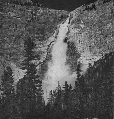 Tongues of glacial ice occupied many of the
valleys in Yoho National Park where swift-flowing mountain streams now
run between gravelly banks and dark forests. In many places they have
steepened the walls of the main valleys and left small tributary valleys
"hanging" on their sides. In this lovely place the meltwaters of Daly
glacier come tumbling over a glacially steepened wall to form this
beautiful plume. © D. M. Baird, 1963
Tongues of glacial ice occupied many of the
valleys in Yoho National Park where swift-flowing mountain streams now
run between gravelly banks and dark forests. In many places they have
steepened the walls of the main valleys and left small tributary valleys
"hanging" on their sides. In this lovely place the meltwaters of Daly
glacier come tumbling over a glacially steepened wall to form this
beautiful plume. © D. M. Baird, 1963
|
Patterns of Rivers
People who can see great tracts of country at one time are often impressed by the patterns which rivers make on the face of the land. Map makers or riders of high-flying airplanes can look at them directly but they can equally well be understood by studying maps of a country. One can readily see that if the rivers of an area are cutting into completely homogenous or even rocks, then the patterns should be predictable, on some sort of purely mathematical basis. But rocks are rarely without some differences in hardness or resistance to erosion from place to place. Thus as rivers cut down into the underlying rocks of a country softer rocks will be more rapidly worn away than harder rocks. The result is that larger valleys are usually cut into areas of softer rocks and the water is concentrated in them to increase the faster cutting. If there is a pattern to the different kinds of rocks, hard and soft, then a pattern should appear in the drainage of an area. Parallel zones of rocks of different resistances should produce parallel drainage patterns. Western Canada has many places where mountains and valleys, which are the results of rivers cutting into uplifted areas, are like parallel windrows with hard rock layers underlying the mountains and softer layers underlying the valleys.
In some areas, rocks of differing hardness are folded into complicated patterns. Drainage soon etches out the soft areas and before long the pattern of the streams will directly reflect the rock pattern beneath. On some parts of the earth's surface the rocks are jointed or broken along rectangular or parallelogram patterns. Streams in the Adirondack Mountains of New York, in several parts of the Northwest Territories, and in Quebec-Labrador, show this systematic pattern as a result of the rock pattern below.
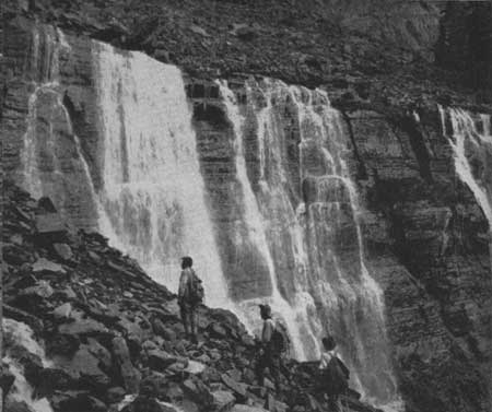 Seven Sisters Falls at Lake O'Hara, Yoho National
Park, tumble over horizontal sedimentary rocks. The accumulation of
sharp, angular boulders above and beside the falls on the left is
typical of regions which are undergoing physical breakdown with very
little chemical decay of the rocks. © Canadian Government Travel Bureau, 1963
Seven Sisters Falls at Lake O'Hara, Yoho National
Park, tumble over horizontal sedimentary rocks. The accumulation of
sharp, angular boulders above and beside the falls on the left is
typical of regions which are undergoing physical breakdown with very
little chemical decay of the rocks. © Canadian Government Travel Bureau, 1963
|
Volcanoes are usually conical mountains and the drainage from them is usually off the slope in all directions. On a map the drainage will thus be radial. We are apt to forget, however, while looking at these unusual types of drainage patterns, that the average pattern is dendritic or branching like a tree. The main river branches, or splits, and each of the branches in turn splits as we travel upstream. When we start up a river looking for the origin we very commonly have to choose between two more or less equal branches to call one of them the main stream and the other one a tributary. It is customary to call the one which is most nearly straight-flowing at the junction the main stream if there is a reasonable closeness of size, otherwise it is the larger.
Rivers that Cross Mountains
When we survey rivers in different parts of North America we find a number of rivers that have unusual relations to highland and mountain areas. The Humber River in western Newfoundland rises in an interior basin area and then plunges through the mountains to the sea at Corner Brook. The rivers of the north side of the St. Lawrence below Quebec City seem to rise in the inner part of a saucer-shaped plateau, then cut through the uplifted saucer-like rim and thence to the sea. In the northeastern United States, the Delaware and the Susquehanna Rivers rise in interior valleys and then cut directly across the mountains. In Western Canada, and adjacent parts of the United States, rivers like the Fraser and the Columbia rise on the landward side of the coastal mountains, run partly parallel to them, and then cut across them to the sea. How can rivers cut their valleys across the mountains? The answer is that the rivers were there before the mountains were made.
Mountains rise very slowly by a gradual upheaval of the earth's outer layers. If a well-established river with a deeply incised valley is flowing across the trend of a rising ridge two things may happen. If the mountain rises faster then the river can cut down through it, there must come a time when the river is dammed off by the mountain and must seek a way around it. If, on the other hand, the river is able to gnaw its way down through the rocks as fast as they rise underneath it, then eventually we may get the situation we have described, a river cutting across a mountain.
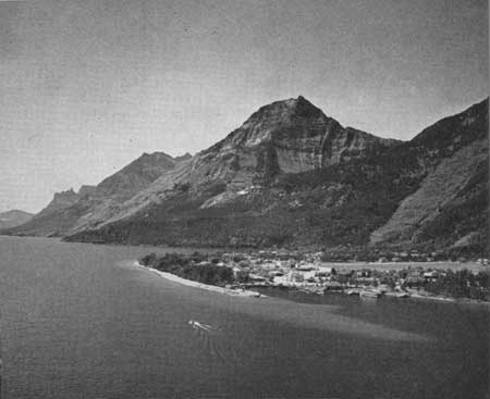 Waterton and the National Park Headquarters are
built on the delta of Cameron Creek which has been smoothed out and
reshaped by the waves of Waterton Lake. All around, the wasting
mountains are making talus slopes and feeding the streams of the area
with sedimentary material. Note how clearly the shallow water shows in
the right foreground. © National Film Board of Canada, 1963
Waterton and the National Park Headquarters are
built on the delta of Cameron Creek which has been smoothed out and
reshaped by the waves of Waterton Lake. All around, the wasting
mountains are making talus slopes and feeding the streams of the area
with sedimentary material. Note how clearly the shallow water shows in
the right foreground. © National Film Board of Canada, 1963
|
There is another way this can happen. Most people are familiar with the idea of a stencil where particular shapes, perhaps letters or designs, are cut out of something. Using this stencil as a guide, the shape can be cut into whatever it is held against. Thus a stencil, made of something soft like wood or plastic, can be held up against something hard like a polished stone and a design etched onto the hard stone with the stencil holding the instrument of cutting. It appears that sometimes in nature a layer of softer rocks overlies a series of hard and soft rocks. If a stream were to cut into the overlying soft rock and down through it into the hard rock, the shape of the valley would be held in the hard rock with the overlying soft rock acting as a stencil. The stream cuts deeply into the hard rocks below, perhaps across their grain, held in by the stencil of soft rocks above. Eventually erosion may remove all of the soft rock. Streams which are tributary to the main river now may etch out softer layers in the basement rocks and gradually form hills, which trend at steep angles to the main stream. Thus we end up with a river appearing to cut straight across the mountains. What has happened again is that the river was there before the mountains. It was stencilled across the grain of the rocks which were later to be etched out into mountain ridges. Needless to say these are not events which take place very quickly, nor are the circumstances common which allow such events to take place. Yet the rivers we have mentioned all have histories something like this.
Summary
In summation, rivers are the fraction of the precipitation which runs off the surface of the land towards the sea. They begin as swift-flowing streams full of rapids and waterfalls and go through a long but systematic cycle of development which ends with them in old age, sluggish, full of sediment, filling in their lower valleys and building large delta deposits. Some of them have unusual patterns because of the kinds of rocks they are cutting into. Some cut across mountains because they were there before the mountains came into being and others have been altered profoundly when glaciers covered the land and disrupted their old courses.
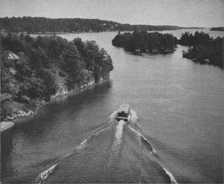 Flooding of the land by water takes place wherever
the drainage is blocked. St. Lawrence Islands National Park is a flooded
country with old hills sticking out of the water as islands and the
lower parts now making a lovely network of waterways. © Canadian Government Travel Bureau, 1963
Flooding of the land by water takes place wherever
the drainage is blocked. St. Lawrence Islands National Park is a flooded
country with old hills sticking out of the water as islands and the
lower parts now making a lovely network of waterways. © Canadian Government Travel Bureau, 1963
|
Even now as we talk of them, rivers are cutting their valleys deeper and wider. Waterfalls are being undercut, rapids being worn down. Sand and silt are being deposited in some places and being scoured out from others. Slowly by human standards of time the rivers of the world are undergoing constant changes as Nature moves on in her cycle. We can witness but a small fragment of the changes taking place but now we can understand what is happening at any one spot and its relation to the whole pattern.