for Visitors in Canada's National Parks
EARTH'S ARCHITECTURE
Sedimentary rocks are laid down on the bottom of the sea in more or less horizontal layers or strata. In places where the sea has withdrawn from the land such sedimentary rocks may be seen in their original horizontal positions. Great areas around the west side of Hudson Bay are like this as are the St. Lawrence Lowland and the Niagara Peninsula.
Rocks and Folded Rocks
On the great plains of Central and Western Canada we note that for thousands of miles the rock formations are flat-lying layers of limestone, sandstone, and shale with occasional layers of conglomerate. We know that they were laid down in ancient seas which once covered those areas, for the rocks are full of marine features, like ripple marks, and fossils or marine creatures. It would seem that the flat rocks of that area are in the same position in which they were laid down. If we travel a little westward, however, we find that the rock layers are undulating blankets which are more and more steeply undulating the farther west we go. It appears that here the rocks have been squeezed and compressed so that they have folded, in much the same way that a carpet is thrown up into wrinkles when we push our foot against it. In the Rockies themselves we can look up at the sides of great mountains and see the folded and wrinkled rock layers or strata in all sorts of contorted attitudes.
Faults
Here, too, we can see where compression became so great that the strata were no longer able to take up the slack by folding but were broken, and the broken slices pushed over one another. These breaks in rocks along which movement has taken place are known as faults. In some places the broken masses of rock can be matched with the roots from which they were torn and the amount of the movement can be worked out. It may be only a few inches or it may be several miles. There is hardly anywhere where the rocks are not broken on some scale by these faults.
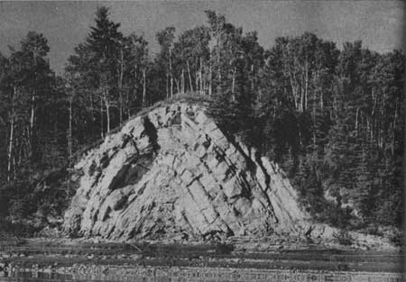  Great pressures in the outer parts of the earth's
framework buckle and fold the rock layers in much the same patterns that
you can make by pushing your foot against the carpet on a hardwood
floor. In this photograph gypsum beds opposite Peace Point in Wood
Buffalo National Park are shown pushed up into an anticline or
upfold. © Geological Survey of Canada, 1963
Great pressures in the outer parts of the earth's
framework buckle and fold the rock layers in much the same patterns that
you can make by pushing your foot against the carpet on a hardwood
floor. In this photograph gypsum beds opposite Peace Point in Wood
Buffalo National Park are shown pushed up into an anticline or
upfold. © Geological Survey of Canada, 1963
|
Some faults make conspicuous landmarks either by the actual motion of one rock wall upward to produce a great line of cliffs, or by providing a zone of weak rock along which rivers may place their valleys because of the ease with which the broken rock can be removed by the running water. The western mountains of Newfoundland end in a great series of cliffs almost 200 miles long. Here a fault system marks a line where the rocks on the eastern side have risen thousands of feet upwards to form the cliffs and to expose older rocks on that side. The mighty Sierra Nevada, in California, 75 miles wide and 400 miles long, is the result of a great tear or fault in the earth's outer layers with tilting towards the west. The long straight valley which leads southwestward from Aspy Bay in Cape Breton has a great fault wall on the northwest side. The Cabot Trail climbs up this great scarp in Cape Breton Highlands National Park. The earthquake in Montana in the summer of 1959 resulted from movement along a fault which left a freshly made cliff 15 feet high and many miles long in the valley of the Madison River.
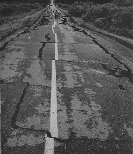 The earthquake in Montana in the summer of 1959. Movement of the
earth is graphically shown by the displacement of the pavement and the
broken centre line on this road. © Albert Moidvoy, 1963
The earthquake in Montana in the summer of 1959. Movement of the
earth is graphically shown by the displacement of the pavement and the
broken centre line on this road. © Albert Moidvoy, 1963
|
Most mountains are the result of both folding or wrinkling of the outer layers of the earth, and faulting. Fabulous contortion of the rocks took place to produce the Alps in Europe. Parts of the Appalachian Mountains are sliced blocks of twisted rocks which once lay horizontal on the floor of an ancient sea. In the Rockies and Selkirks in the National Parks of Western Canada many examples of this folding and faulting are seen.
The movement along faults is sometimes actually visible at the time of break, although it is best to be somewhere else at the time. Hundreds of people were in the vicinity of the fault in Montana mentioned just above. The California earthquake of 1906, after which a great deal of San Francisco burned, was due to horizontal movements along a 250-mile section of the San Andreas fault. One side of the fault moved horizontally past the other by a maximum of 21 feet. In other places the sudden movement along faults, really a snapping motion which suddenly releases gradually accumulating stress, has produced assorted movements of a few inches to 80 feet. Earthquakes are really the shock waves which move out from the great bang that results when the rocks break and move abruptly past one another.
All this description seems to mean that the outside layers of the rocky earth are flexible up to a point at which they break and tear. The result is that folded, twisted, and contorted strata with faults or breaks in them are common in some parts of the world. In other places the strata or layers are as flat and undisturbed as the day they were laid down on the bottom of the sea.
Igneous rocks bend and break in the same way as sedimentary rocks but one would not expect great masses of granite to do much folding. Sometimes in granite masses faults seem to be about the only visible structure.
It may seem a little difficult to think of rocks being folded because in our ordinary experience they are strong and resistant. Forces within the earth, however, are adequate to bend and break even the resistant rocks.
Kinds of Folds and Faults
The kinds of folds and faults which are produced can be classified into a few groups, and while this is a subject for the experts we can improve our appreciation of scenery and what we are looking at by learning a little about them.
If we wrinkle up a carpet on a floor we can see that two kinds of folds are produced, which we can call upfolds or arches and downfolds or troughs. Each fold has two sides. In the upfolds the two sides dip away from each other as we travel down from the crest and are called anticlines on this account. The sides or limbs of the troughs or downfolds dip toward one another and are called synclines. Anticlines and synclines are similarly produced in rocks by compression or squeezing together.
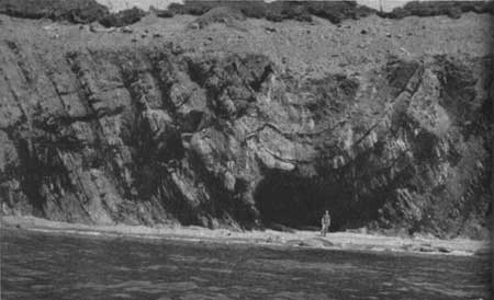
 Mountains to the east of Banff lie in that part of
the Rocky Mountain system that is characterized by great folding and
faulting. The rocks on the far wall in this view show a syncline or
downfold to the left and an upfold or anticline to the right. Waste from
the eroding mountains accumulates as scree slopes below.
Mountains to the east of Banff lie in that part of
the Rocky Mountain system that is characterized by great folding and
faulting. The rocks on the far wall in this view show a syncline or
downfold to the left and an upfold or anticline to the right. Waste from
the eroding mountains accumulates as scree slopes below.
|
Faults or breaks along which there has been some movement may be produced by compression too. Rocks may first fold and crumple when they are squeezed. If the compression gets more severe the rocks may break along irregular planes with a low dip and the upper slice may move across the lower. Such faults are called low angle thrust fault and movement along them may be as much as several miles.
Other faults are produced when rocks are stretched. Most of these are steeply dipping and, when anybody looks at one in the side of a mountain, it gives the impression that the rocks have been broken apart and one side has dropped down. When large granite masses cool they shrink a good deal and tension or stretching may cause numerous faults along their margins. If there is no movement to speak of along such breaks they are called joints. All rocks seem to be broken in this manner in some degree and in some places the joints are so closely spaced that it is difficult to get out a block of stone more than a few inches long.
Veins
When joints or cracks in rocks are filled with some material other than the surrounding rock we refer to the structure as a vein. Groundwaters percolate through adjacent rocks and may dissolve out some material such as calcium carbonate or lime and then precipitate it in openings. Waters from hot igneous masses, deep below the surface, may also fill spaces in rocks and veins. Calcite and quartz are the most common vein fillings and you may be able to identify these minerals from the Table of Minerals facing page 28.
Veins may be several feet thick and a mile long or may be paper-thin and only a few inches long. They may be filled with coarse grains of some mineral or with a fine featureless mass. When veins are not completely filled the openings in them may be lined with lovely crystals. Some veins have valuable minerals concentrated in them and are mined.
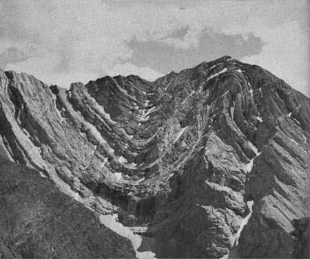
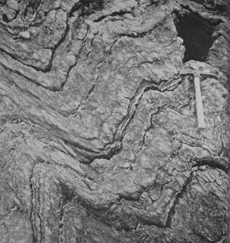 Anticlines and synclines (upfolds and downfolds) almost always occur
together. Here a rock has been folded into a wavy pattern by
compression.
Anticlines and synclines (upfolds and downfolds) almost always occur
together. Here a rock has been folded into a wavy pattern by
compression.
|
Summary
Rocks are not solid and immovable as they may seem but, instead, may be wrinkled and folded, broken and pushed about. Cracks and openings in them may be filled with secondary materials to form veins.