for Visitors in Canada's National Parks
OCEANS AND SHORELINES
For people who grow up near the coast no scenery is quite complete without the ocean. Here, great cliffs stand firm against the onslaught of rollers which have come across hundreds of miles of open sea to smash against them. Icebergs may drift slowly into view and then pass southward to their fate in warmer waters but in their transit of our shores show us beauty in their whiteness on the dark water. In times of calm, a beautiful sunset may be doubly enhanced by reflection from the mirror of the sea. For hundreds of generations men have been fascinated by the ocean, in its savagery of storm and wind, or in its peaceful and reflective calm.
For the scientist or for him who understands something of the processes at work there, the oceans are not only very beautiful but are also storehouses of fascinating phenomena. The geologist looks at the oceans and sees them as great basins in the crust of the earth which are filled to overflowing with salt water, the rugged landscapes of their bottoms being scoured by currents in some places and being covered in others with a great variety of oozes and muds. He sees the shoreline as the scene of a great struggle between the processes of erosion and deposition, of destruction and building. The geologist also wonders about the manner of distribution and deposition of the land which are brought to the sea by countless rivers and by the waves themselves. He is interested in the chemical and biological makeup of oceans for they are the parents of most sedimentary rocks.
Other scientists are apt to see other parts of the oceans. Biologists may see the oceans as the cradle of life and the place where more living things in greater diversity of kinds are to be found than in any other environment on the face of the earth. Physicists may see the oceans in terms of earth magnetism, gravity or heat transfer. The chemist sees a solution of salts of various kinds complicated in their interaction by a vast mass of living material. Mathematicians and astronomers are concerned with the oceans as they modify the shape of the earth or change its rotation because of the drag of marine tides.
Oceans Generally
A close look at a globe or a world map will show that about two-thirds of the surface of the earth is covered with oceans. We have already mentioned that continents seem to be discrete blocks which stand up above the ocean basins along fairly sharply marked boundaries. It seems, furthermore, that the ocean basins are a little more than full because some of the water encroaches on the edges of the continental masses. The areas that are thus covered with water are called continental shelves and aggregate something like 10 million square miles or about 2-1/2 times the land area of Canada. The width of them varies considerably, from a narrow rim along the Pacific coasts of the Americas to 250 miles, east and south of Newfoundland in the famous Grand Banks, and even 400 miles along the Siberian Arctic coast.
The slope on the shelf areas descends gently seaward under the water at the rate of only 10 to 20 feet a mile. Then at the outer edge the slope steepens and drops off into the ocean depths. Thus the real shape of the continent of North America would look rather different from the present shoreline map of North America that we are accustomed to, for many of the features like Hudson Bay which lies on top of the continental block would not show and things like the Grand Banks would be land areas.
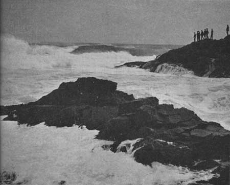 Men have always been awed by storms on the sea.
Here a granite shore resists the onslaught of great breakers which may
have come many miles across the surface of the sea to crash against it.
The force of the moving water may remove blocks bodily, bits and pieces
of rock may be hurled against the shore, solution and chemical
decomposition go on apace. © D. M. Baird, 1963
Men have always been awed by storms on the sea.
Here a granite shore resists the onslaught of great breakers which may
have come many miles across the surface of the sea to crash against it.
The force of the moving water may remove blocks bodily, bits and pieces
of rock may be hurled against the shore, solution and chemical
decomposition go on apace. © D. M. Baird, 1963
|
Ocean depths are as highly various as the places at which they are measured, for the bottom of the sea is about as irregular as any land surface. The maximum depth is nearly 40,000 feet, which means that the deepest part of the sea is much deeper than the highest part of the land is high. Parts of the ocean bottoms which lie below about 18,000 feet are called deeps. The deepest of the deeps are elongate trenches or troughs which are often near continental margins, where folded mountains are found or arcs of islands, like the Aleutians. They are thus thought to be of structural origin, that is, down-wrinkles on the bottom of the sea. The average depth of the sea is much less than its greatest deeps, of course. The Pacific Ocean is about 14,000 feet, the Indian Ocean is about 13,000 and the Atlantic about 12,900 feet. While these figures cannot be accurate to the nearest foot they do show us in a general way how thick the watery blanket of the oceans is on the surface of the earth.
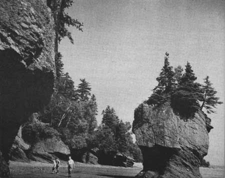 Conglomerate and sandstone dip gently toward the
sea at Hopewell Rocks, N.B. on the road which leads to Fundy National
Park from Moncton. These curious shapes result when softer parts are
worn away leaving harder parts standing isolated or as points jutting
out from the bank. Note the boulders and pebbles in the dipping
sedimentary rocks. © Canadian Government Travel Bureau, 1963
Conglomerate and sandstone dip gently toward the
sea at Hopewell Rocks, N.B. on the road which leads to Fundy National
Park from Moncton. These curious shapes result when softer parts are
worn away leaving harder parts standing isolated or as points jutting
out from the bank. Note the boulders and pebbles in the dipping
sedimentary rocks. © Canadian Government Travel Bureau, 1963
|
It is interesting to note that with the earth some 8,000 miles in diameter and the oceans about 13,000 to 14,000 feet or 2-1/2 miles deep, the water is a pretty thin film on the outside of the ball we live on. We are apt to gather a different impression from our travels on the earth's surface.
The Bottom of the Sea
What is the bottom of the sea like? In earlier times the only way to find out the depth of the water at any one spot was to stop a ship and lower a weight on the end of a rope or wire. Because of this slow and difficult method, observations of depth were very sparsely scattered over the oceans. As a consequence, ocean bottoms were pictured as very smooth, gently sloping affairs with only minor undulations over enormous areas. Only a few of the great deeps, a few of the major submarine ridges, and a few of the canyons were known. In recent years, however, a device has been invented which measures the depth by sending out a sound wave and timing its trip down to the bottom and back. Since the speed of such sound in water is known, then the depth can be accurately measured. With this device the captain of a ship needs only to push a button and read on a dial the depth of water beneath his keel. These instruments have been refined to produce an accurate, continuous record of depths over which a ship is passing so that a map of the bottom is possible by making a number of evenly spaced, parallel trips. This technique has suddenly made clear to us that the sea bottom is not the flat monotonous landscape we used to think but instead presents a great diversity of relief and topographic types. Naturally enough, the absence of streams, and wind, and desert types of erosion makes it impossible to have certain of the finer details of sculpturing of the landscape, but this is compensated for by some forms which are peculiar to the ocean bottoms.
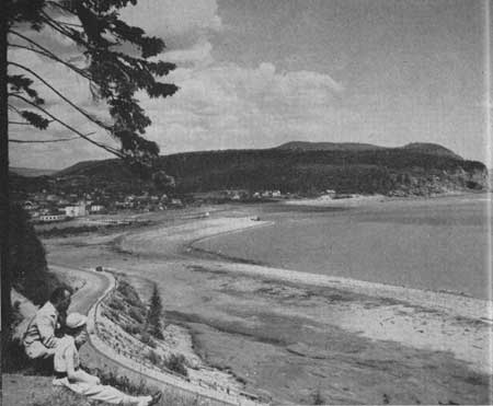 Part of this curving beach is in Fundy National
Park, near the village of Alma and Owl's Head. Waves and currents carry
the materials of erosion from the crumbling cliffs and build these
beaches. Notice how the waves have piled up a beach ridge at highest
water level. © Canadian Government Travel Bureau, 1963
Part of this curving beach is in Fundy National
Park, near the village of Alma and Owl's Head. Waves and currents carry
the materials of erosion from the crumbling cliffs and build these
beaches. Notice how the waves have piled up a beach ridge at highest
water level. © Canadian Government Travel Bureau, 1963
|
In very recent years man has found ways to go into the great depths of the sea himself and look at the bottom. Some penetration of the upper parts of the ocean was made before this by men who sealed themselves into a strong, water-proof sphere with windows in it and then dangled at the end of a long rope from the decks of a surface vessel. Since World War II penetrations to depths as much as seven miles have been made by suspending the gondolas below bags which are filled with liquids which are lighter than water. The whole apparatus is then manipulated like a balloon with ballast adjustments to make it rise or sink. A whole new world of discovery has been suddenly opened up. Now what do we find?
The sea bottom is covered with great mountain ranges like the Mid-Atlantic Ridge which runs up and down the Atlantic Ocean from end to end; valleys of great depth; rugged volcanic mountains tens of thousands of feet high, and perhaps poking a bit out of the water as islands such as Hawaii and Bermuda. Thus some island areas of the world prove to be but the tips of giant mountain masses, as large in relation to their surroundings as any we know on the surface of the land.
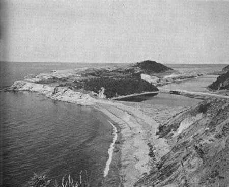 Seacoasts are constantly undergoing change as
waves and currents cut into the rocky cliffs and strew the debris from
them along the shore. This island, on the west shore of Cape Breton
Highlands National Park, has been joined to the main shore by the spit
in the foreground as waves and currents carried the debris from the
eroding cliffs across the gap. © Canadian Government Travel Bureau, 1963
Seacoasts are constantly undergoing change as
waves and currents cut into the rocky cliffs and strew the debris from
them along the shore. This island, on the west shore of Cape Breton
Highlands National Park, has been joined to the main shore by the spit
in the foreground as waves and currents carried the debris from the
eroding cliffs across the gap. © Canadian Government Travel Bureau, 1963
|
By far the most complicated relief on the sea floor is to be found around modern island chains where volcanic and earthquake activity is apparently a part of a mountain-building process in action. Such places are the Indonesian Archipelago and the West Indies. Here, basins and trenches alternate with prominent ridges, some of which stick out above the sea as the islands we know. Isolated volcanic cones, some of which protrude above the surface, appear scattered over the sea. In addition, plateaus and flat areas are found, some of them with drowned river-valley systems superimposed on them. So now we think of the bottom of the sea as an area of relief something like that we know on land, with flat areas, mountains and valleys, submerged plateaus and isolated hills.
It has been known for a very long time that the bottom of the sea is covered with different kinds of things in different places. The charts made by Captain Cook in Eastern and Western Canada in the late 18th century show where individual soundings were made and whether the bottom was sand, mud or rock. This is still important to sailors for it makes a difference where one might drop an anchor.
One would expect that near the land and in shallow waters sedimentary materials derived from the land would be most common. These would be mud and silt, sand, and, very close to shore, gravel. Once off the continental margins and into the great ocean depths, however, the sedimentary materials are very different. Bluish-grey muds of fine grain cover the sea bottoms close to the continents. They are probably derived from the lands and carried on out very slowly in fine suspension. Very fine, clay particles may take years to settle through the depths of sea water in these zones, so can stray out from shore a long distance.
In the very deep, sea regions the most widespread stuff of the bottom is red clay. It covers a quarter of the floor of the Atlantic and Indian Oceans, and about half of that of the Pacific Ocean. It varies from brick-red to brown and is very fine grained. It seems to be a combination of many things like wind blown dust from the land, volcanic ash blown out over the sea in winds, meteoric dust, and perhaps some land-sediments straying out over the depths in ocean currents.
Great numbers of microscopic organisms live in the surface waters in some parts of the ocean and secrete around themselves little skeletons of calcium carbonate or silica. When the animals die their shells sink slowly to the bottom of the sea. If muds and other masking sediments are present in large quantities it may be that the shells go unnoticed. But if little or no muds are coming into the area the tiny shells accumulate and form ooze. These oozes, of several kinds, cover vast areas of the ocean bottoms. One type alone, named globigerina ooze for the little creature which makes it, covers some 50 million square miles.
We have seen, now, enough of the overall picture of oceans and the basins they lie in to investigate the place where most of us see the ocean—at the shoreline. It is here that the waves come in procession from out beyond and crash against the land, or, in calm weather, wash gently the rocks and the beaches. It is here, too, that waves form the most effective tools of erosion at the command of the sea, tearing down cliffs and scattering the debris along the shore as beaches, bars and spits.
Waves
The movement of ocean waves produces hydraulic forces of considerable size by sheer impact of moving water. Investigators have estimated that storm waves produce pressures as high as 50 pounds per square inch. This may not sound like much until we see that it is about 3-1/2 tons per square foot and a seawall or a rocky point of a few hundred square feet would have to stand pushes of hundreds of tons as the waves come in one after another. Records of great gales are full of stories of enormous boulders of hundreds of tons being moved about by storm waves, and breakwaters of even thousands of tons being washed away. The alternating great pressures of the advancing waves and their withdrawal effectively wear away the rocks in some places. Air is forced into pore spaces of rocks and into openings and cracks under great pressure by the waves and helps in the process of destruction.
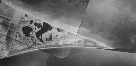 Point Pelee juts out into Lake Erie from the south side of Ontario.
In this composite picture made from several aerial photographs you can
see how the waves and currents are swirling up the water and sand on the
east side of the point and south of it into deeper water. You can also
see the marks of older shorelines on land. The neat rectangular areas
are fields under cultivation and the dark, irregular areas are boggy
ponds. © Royal Canadian Air Force, 1963
Point Pelee juts out into Lake Erie from the south side of Ontario.
In this composite picture made from several aerial photographs you can
see how the waves and currents are swirling up the water and sand on the
east side of the point and south of it into deeper water. You can also
see the marks of older shorelines on land. The neat rectangular areas
are fields under cultivation and the dark, irregular areas are boggy
ponds. © Royal Canadian Air Force, 1963
|
But the most effective way the waves work is by abrasion. You may recall that in an earlier section we mentioned James Hutton, a Scot who was among the first of the modern school of geological workers. Here is what he said about abrasion along shores undergoing active erosion:
|
"On such shores, the fragments of rock once detached become instruments of further destruction, and make a part of the powerful artillery with which the ocean assails the bulwarks of the land; they are impelled against the rocks, from which they break off other fragments, and the whole are thus ground against one another; whatever be their hardness, they are reduced to gravel, the smooth surface and round figure of which are the most certain proofs of a detritus which nothing can resist." |
No one can doubt this who has stood on the shore, as Hutton did so long ago, and watched waves sweep forward, tumbling rocks of all sizes against one another and the cliffs and then the backwash with a repeat of the tumbling and rolling action. On many beaches the backwash has a distinctive roaring sound because of the pounding of the boulders and cobbles in motion against one another. No wonder wave-worn boulders are rounded.
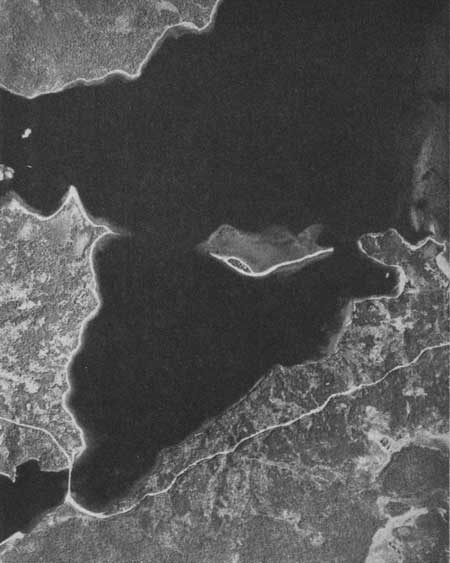 Waves and currents are tearing down an island of
sand on the north side of Terra Nova Park and stringing the sand out
into a long spit. Beaches and the curving road appear in this aerial
view as dazzling white while the sea is very dark looking because we are
actually looking down into its depths. You can see the large shoal area
around the island and the point of land to the left. © Royal Canadian Air Force, 1963
Waves and currents are tearing down an island of
sand on the north side of Terra Nova Park and stringing the sand out
into a long spit. Beaches and the curving road appear in this aerial
view as dazzling white while the sea is very dark looking because we are
actually looking down into its depths. You can see the large shoal area
around the island and the point of land to the left. © Royal Canadian Air Force, 1963
|
Sand and Mud
Now, what happens to the material that is worn away from shores and ground up by waves? It must go forward on the waves to be deposited on or near the beach or backwards towards the sea. If backwards, the waves may deposit the stuff in deep water immediately or feed it to currents which, in their turn, transport the sedimentary materials into deep water. These currents may come from large-scale ocean movements generated by the earth's rotation, the tides, the great winds in certain sections, or differences in temperature in ocean waters in different parts. Locally they are apt to be the result of the waves themselves hitting the shore obliquely.
Beaches, then, such pleasant places in fine weather, really represent destruction of cliffs or older deposits of sands and gravels. Waves break off pieces of rock and grind them against one another. Particles of sand gradually get rounded off and weaker materials get ground even finer than resistant ones. Because of this grinding and elimination of softer materials most beaches have a large proportion of particles of quartz, a commonly occurring, hard, resistant mineral. It is perhaps intriguing to think that the great mass of quartz sand on a beach has come from a much larger mass of rock by the gradual elimination of other materials.
Any handful of sand will show many other mineral fragments besides quartz such as black specks of a magnetic iron mineral, magnetite; pink, glassy garnet; green, glassy olivine; grey, pink or brown feldspar; shiny, flat flakes of mica which may be brown or silvery. In some beaches very rare minerals are concentrated by wave action and may even form valuable mineral deposits. It is always worthwhile to examine sand closely for it may be full of interesting and beautiful mineral grains.
It is interesting to note the way that water in motion, whether in waves or in currents, selects different materials from a mixture and concentrates them. Watch carefully where waves sweep onto a sandy beach and see, at the very maximum line of forward sweep of the water, a tiny little zone of light materials left behind, things like flakes of mica, or fragments of shells and wood. Areas of darker sand occur on some parts of the beach where waves have carefully selected dark mineral fragments, because of their weight or shape or size, and deposited them. Where ripple marks have formed you may note that the sand in the tops of the ripples is of various minerals in slightly different proportions from that in the troughs between them.
The sedimentary materials being sucked away from the line of waves at the shore are moved selectively too. Finer particles will be moved farther seaward and the coarser or heavier particles will be deposited on the bottom sooner or nearer shore. The farther seaward one goes, the finer the sedimentary materials so that hundreds of miles from land only the very finest of clay particles remain in suspension, and even these gradually sink to the floor of the ocean to become part of the bottom muds and oozes.
Different Kinds of Shorelines
We have seen something now of the bottom of the ocean and what it is like, about the kinds of muds and oozes which cover it, about the way waves wash in against the shore and wear it away, about beaches and sands. Now what about different kinds of shorelines? For these, after all, are what we usually see in our travels, and, further, what we usually come to appreciate as marine scenery. Why is the deeply indented shoreline of British Columbia with great fords and deep narrow inlets so very different from the smooth, straight shore of Oregon? Why is the equally spectacular fiord-land of Labrador so very different from the smooth, straight shorelines of Anticosti Island, of Gaspé? Why, indeed, are there so many islands in Notre Dame Bay and the Terra Nova National Park area on Newfoundland's north coast, and hardly any at all on the west side of Hudson Bay? Why are some shorelines so steep and rugged and others so low and flat?
To understand kinds of coastlines we must recall that oceans and continents are separate, and that the ocean basins are a little more than brim-full, so that the oceans overlap shallowly on the edges of the continents. This means that the slightest alteration of the sea-level relative to the land will mean a big change in the shoreline.
Study of the earth's past has shown that the oceans and the continents have always been in a state of adjustment, of ups and downs with consequent raising and lowering of the sea level at any one place. Thus shorelines in some places show how the sea has encroached on the land; that in others it has withdrawn from the land, so that the place where waves used to wash the rocks, is now dry land; still others are places where the sea level has been more or less stationary for very long periods of time. Here, right away, is a basis for classifying shorelines, whether they are submerged or emerged or stationary. There are lots of other ways to classify shorelines: the tourist-resort owner, wanting to expand his facilities, will classify shorelines on the presence or absence of good swimming beaches or surfing beaches, the sailor on whether good harbours are to be found there, the fisherman on the fish populations off-shore, and so on.
It makes a great difference to the shoreline of submergence or that of emergence just what kind of topography is being submerged or emerged. Thus shorelines may be classified as shorelines of plains or flat areas, and shorelines of mountainous areas.
About the most satisfactory classification for both geologist and traveller, however, is one which is based on whether or not the waves and currents are the principal causes of the shapes or configurations of the shorelines. This may seem odd but, if we remember our continental margin again with the water spilling shallowly up on its gently inclined edge, we can easily see that many shorelines would be the result of submergence of the land in the sea, because the continent has gone down a little or the sea has risen a little. If we submerge or drown a piece of landscape in the sea, the shoreline will take its shape from the land. If an irregular, hilly piece of land is submerged beneath the sea the hills may stick out of the water as islands or long headlands and the valleys, now filled with sea water, will form long bays or estuaries. The more irregular the land, the more irregular the new coastline will be when it is submerged. Thus our island-studded coastlines, be they on the east coast or the west coast, on the shores of large lakes or in the Arctic Ocean, are almost always the result of water drowning the land. Thus the shapes of some shorelines are due not to marine agencies at all but to land erosion, followed by drowning. So we find lots of different kinds of shorelines whose primary features are due to the drowning of river valleys, the drowning of areas eroded by glaciers, the submergence of areas of river deposition, glacial deposition, or even wind deposition.
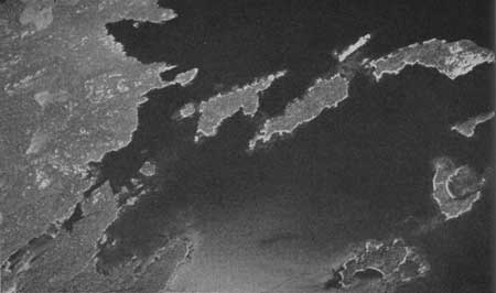 Sometimes a view from high in the air helps us
appreciate the overall pattern of the landscape which is not easily
visible when we stand in the midst of it on the ground. Here is an
aerial view, in Terra Nova National Park, which shows how drowning of a
rolling landscape produces an irregular shoreline. Former hills appear
as islands and valleys are filled with water to become inlets and
coves. © Royal Canadian Air Force, 1963
Sometimes a view from high in the air helps us
appreciate the overall pattern of the landscape which is not easily
visible when we stand in the midst of it on the ground. Here is an
aerial view, in Terra Nova National Park, which shows how drowning of a
rolling landscape produces an irregular shoreline. Former hills appear
as islands and valleys are filled with water to become inlets and
coves. © Royal Canadian Air Force, 1963
|
On Canadian shores we have a large variety of submerged landscapes forming the present coastline. In northern Labrador and in much of British Columbia we find great fiords or glacial troughs, thousands of feet deep, leading into the land. They have been deeply cut by glaciers and then invaded by the sea, although in some places the ice may have been cutting below sea level in them. Drowning of a normal, rolling topography with river valleys and ridges produced what is now the island-filled northern coast of Newfoundland. This is how the marine scenery in Terra Nova National Park was formed. A short distance toward the west, the Exploits River can be traced on the sea bottom for 40 miles beyond its present mouth, out among the islands off the shore. The same history of submergence by the sea of a rolling landscape has produced the indented shore of Nova Scotia and New Brunswick.
Other coasts and shorelines have configurations which are primarily the result of waves and currents. Here we find the great cliffed shoreline. The pictures of Perce and the great limestone cliffs of Gaspé are familiar to almost everyone. The cliffed shores along parts of Lake Huron, some of the Arctic islands, and portions of the west coast, would belong here, for the cliffs have been cut by the waves themselves. Some coasts are made more regular by the cutting off of exposed promontories and removal of islands. Others are made more irregular as waves and currents cut into soft rocks, making indentations and etching out harder rocks as points.
 The southernmost tip of mainland Canada is this
long spit of sand and gravel in Point Pelee National Park. It is made by
the sweeping of currents which are generated by winds and waves on the
north side of Lake Erie. © Canadian Government Travel Bureau, 1963
The southernmost tip of mainland Canada is this
long spit of sand and gravel in Point Pelee National Park. It is made by
the sweeping of currents which are generated by winds and waves on the
north side of Lake Erie. © Canadian Government Travel Bureau, 1963
|
Waves and currents may shape shorelines by adding beaches and bars of sand and gravel torn from eroding shores nearby. The long point of Point Pelee National Park was made by currents and waves. Thus, bays may be filled in or cut off by wave deposits, islands may be joined by bars, or irregular coastlines made smooth by the formation of long, straight off-shore bars. A glance at the map of eastern North America will show a shoreline, made straight and even in this way, which extends from Cape Cod southward to the tip of Florida, around the Gulf of Mexico and on down to Yucatan Coral islands, and shorelines which have been altered greatly by coral reefs, such as the magnificent Great Barrier Reef of Australia, belong in this class also.
Summary
When next you visit the shoreline, be it that of a small lake or the mighty Atlantic, that of a wide river or the stormy old Pacific, you will see there the meeting place of water and land. As waves lap the shore gently or come crashing in with force of untold might, grains of sand are disturbed, muds stirred up and resettled, boulders ground against one another. The ocean water off Newfoundland, today cold, filled with icebergs, teeming with cold-water fishes and micro-organisms, may in a little while find itself in the warm stagnance of the Sargasso Sea, or bathing the shores of Europe as part of the Gulf Stream, or perhaps part of the tumultuous waters of the 'roaring forties' in the southern oceans. Vancouver Harbour water may one day be part of a languid scene in the South Pacific or find its way into arctic seas.
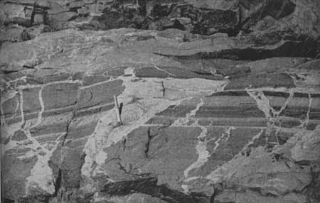 Intrusive igneous action takes place below the
surface of the earth, and the results of it are only exposed to view
after long erosion. In this exposure on the coast of Newfoundland we can
see how the dark banded rock was split apart by the intruding white
rock, which then solidified. © D. M. Baird, 1963
Intrusive igneous action takes place below the
surface of the earth, and the results of it are only exposed to view
after long erosion. In this exposure on the coast of Newfoundland we can
see how the dark banded rock was split apart by the intruding white
rock, which then solidified. © D. M. Baird, 1963
|
Where you see waves and currents cutting at cliffs and building bars and spits with the debris, or spreading it out over beaches where you walk, you may relate the processes you are observing to the constant striving for equilibrium in nature. For you are looking at a tiny fragment of a vast process of disturbance and adjustment, here something torn down and there something being built up, as Nature moves on in her cycle.