|
|
 |
Canadian Historic Sites: Occasional Papers in Archaeology and History No. 3
The Armstrong Mound on Rainy River, Ontario
by Walter A. Kenyon
Introduction
The Armstrong Mound (Royal Ontario Museum Code No.
L.S.M. — 7) is one of a group of at least 11 Indian burial mounds
scattered along the north bank of Rainy River (Fig. 1) at the Long
Sault Rapids (Fig. 2) some 32 mi. west of Fort Frances, Ontario. The
mounds are located on "Plan SM-74, being a sub-division of Long Sault
Indian Reserves Nos. 12 and 13, Chapple Township, Rainy River District,
Ontario." The mound is located specifically on the boundary between the
Chapple Township road allowance and Lot 30, 275 ft. north from Rainy
River (Fig. 3). Its geographic coordinates are N. 48° 30' 48.4" and
W. 94° 4' 22.5".

1 Location of Long Sault Rapids on Rainy River.
(click on image for a PDF version)
|
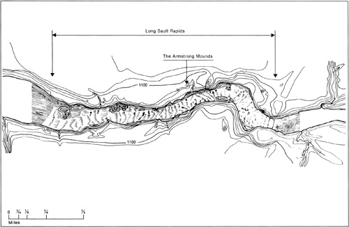
2 Location of Armstrong Mound at Long Sault Rapids.
(click on image for a PDF version)
|

3 Location of Rainy River.
(click on image for a PDF version)
|
The Armstrong Mound, with which this report is
primarily concerned, is part of a large site complex. The larger site
appears to consist of a number of separate and overlapping camp and
village sites scattered along the Ontario shore of Rainy River for a
distance of 1.5 mi. At present, it is not known whether the deposit of
cultural debris is continuous or discontinuous, as very little testing
has been done. We do know, however, that the horizontal distribution of
material is extensive, that it extends inland from the river for 300 ft.
in places, and that the eastern edge of the site is stratified, with
Blackduck overlying Laurel materials. The deepest deposit encountered in
the very limited testing that has been done does not exceed 14 in.
The most salient features of the site are the burial
mounds, which are of two basic types. A number of small low mounds can
probably be attributed to the Blackduck occupation. Although these have
not yet been adequately surveyed, it is highly improbable that any of
them exceeds 30 ft. in diameter or 30 in. in height. There are a number
of larger and relatively higher mounds which were built by the earlier
Laurel peoples. Most of these are over 50 ft. in diameter and 6 ft. in
height. The largest is 113 ft. in diameter and 24 ft. high.
The earliest material yet found at the site can be
attributed with reasonable accuracy to the Plains Archaic period, and
dated at roughly 6,000 B.C. (Kenyon and Churcher
1965). A number of bone and antler
harpoons, grooved axes and large copper implements have been picked up
along the river bank from time to time, but these cannot be assigned to
any particular occupation at present. The most recent material of
archaeological significance at the site consists of burials
dating from the fur trade period. Although we have no reason to believe
that the occupation of the site has been continuous, we do know that it
has been occupied intermittently for some 8,000 years, and we can be
fairly confident that it has been a religious and ceremonial centre for
the last 2,000 years.
In addition to these considerations, the site is
important simply because the mounds are visible. Most of Canada's
prehistoric archaeological sites have neither mounds nor other earthworks.
While these sites are important to the prehistorian, they cannot
normally be used as visual aids in an educational program. At the Long
Sault Rapids, on the other hand, the mounds stand forth boldly as
man-made structures. Their very massiveness is impressive.
The value of the Long Sault site as a unique record
of Canadian history cannot be seriously questioned — both the
length of occupation and the diversity of the cultures that
are present attest to its importance — but like a gold mine, it is
of no value unless it is worked.
|
