 |
|
Canadian Historic Sites: Occasional Papers in Archaeology and History No. 26
by Karlis Karklins IntroductionHistorical Background Although the Canadian fur trade had been expanding westward from its inception, the period of major English expansion northwest of the Great Lakes began in the 1770s (Smythe 1968: 10, 17). During this period, the Montreal pedlars began turning their attention to the country that lay to the north of the Saskatchewan River. The Frobisher brothers were the first to enter the area and had penetrated as far as Ile-à-la-Crosse by 1776 (Smythe 1968: 16). Their profitable ventures proved that the area was rich in furs, and as a result other traders followed shortly thereafter. One of the first to exploit the new territory was Peter Pond who, in 1778, established Pond's Fort on the Athabasca River, about 30 to 40 miles from its mouth. Operating as a "free trader" for the first few years, Pond became a partner in the newly formed North West Company in 1785 which thereby gained the only post in Athabasca (Chalmers 1974: 51). Pond's Fort functioned for another three years and was then abandoned for a site on Lake Athabasca since the old establishment was not in a suitable location either as a base for the exploration of the country to the north and west of the lake or to adequately trade with the Indians of the region. Further, it lacked the resources to support an establishment large enough to meet the future requirements of the Athabasca area (Smythe 1968: 249). The new post, Fort Chipewyan I, was constructed in 1788 by Roderick Mackenzie on a small peninsula on the south shore of Lake Athabasca, about 6 miles to the east of the Athabasca River delta. This location was in the centre of excellent fisheries and near the mouths of the Athabasca, Slave and Peace rivers and at the hub of a vast network of water routes. It was also about as far west as a post could be placed and still allow canoes from the fort to rendezvous at Grand Portage in the summer, exchange furs for supplies and return to the north before the rivers and lakes froze over (Chalmers 1971: 8). Although relatively little is known about this post, it was a sizeable operation, being deemed "the compleatest Inland House I have seen in the Country" and "the Grand Magazine of the Athapiscow Country" by Philip Turnor who visited the site in 1791-92 (Tyrrell 1934: 398). During the 12 years of its existence, Fort Chipewyan I served as company headquarters and as the chief trading establishment in Athabasca, as well as a base of operations for the exploration of the northwest and the subsequent expansion of the North West Company into the explored regions. The fort was also a redistribution centre for furs coming from and supplies going to the other posts in the district. In the late 1790s, the importance of Fort Chipewyan I began to decline. The tremendous expansion of the Athabasca Department during this period was at the root of the difficulty (Smythe 1968: 250). With posts westward along the Peace River and north on the Mackenzie diverting some of the concern's attention, Fort Chipewyan suffered. Consequently around 1800, the post was relocated on the lake's northwest shore in the immediate vicinity of the present settlement of Fort Chipewyan, Alberta. This locale was free of ice sooner than the old site, thereby allowing the earlier departure of the traders in the spring. It was also much closer to the Slave and Peace rivers, as well as nearer to the major fur suppliers, the Chipewyans, whose territory lay to the east and north of the lake. The move did not end the post's troubles however. At about the same time that Fort Chipewyan was relocated, Alexander Mackenzie's XY Company established a post in the immediate vicinity (Smythe and Chism 1969: 89). Further competition in the form of the Hudson's Bay Company appeared in 1802, when Peter Fidler established Nottingham House on English Island about two miles from Fort Chipewyan II. Nevertheless, the competition was short-lived. By 1806, the North West Company had absorbed Mackenzie's concern and driven the Hudson's Bay Company from the area (Smythe 1968: 246, 248). With the two companies out of the way, the Nor'Westers once again had a monopoly in the Athabasca region. It was not until 1815 that the Hudson's Bay Company reentered Athabasca to challenge the North West Company's hold on the area once again. In that year John Clarke, a former Nor'Wester, built Fort Wedderburn on Potato Island opposite Fort Chipewyan. This post was occupied until October of 1817, when it was decided that a residence on the island would not be feasible that winter because of a lack of dogs to haul fish to the fort from the outlying fisheries (Krause 1972: 28). Temporary headquarters (Fort Wedderburn II) were, therefore, erected on Old Fort Point which had always been considered an excellent fishery. However, the new location did not prove to be any better than the old one had been; by 25 March 1818, the Hudson's Bay Company men were back on Potato Island (Krause 1972: 29). Fort Wedderburn continued in existence until 1821, when the union of the North West Company and the Hudson's Bay Company brought an end to the bitter rivalry between the two establishments. Fort Wedderburn was subsequently abandoned and Fort Chipewyan II became the Hudson's Bay Company's district headquarters and principal northern depot for western Canada. Although the importance of Fort Chipewyan II declined gradually after 1821 due to the depletion of the fur resources of the area, it remained the main trading post in the Athabasca District for over a century (Smythe 1968: 247); however, as the fur trade in the district diminished, the need for the post diminished as well. Hence, in 1939-40, the buildings at the site were either torn down or moved to new locations to serve as storage facilities and a modern Hudson's Bay Company store was erected in the town that had grown up around the post over the years. Now only a stone cairn marks the site of the post that was once called the "Emporium of the North."
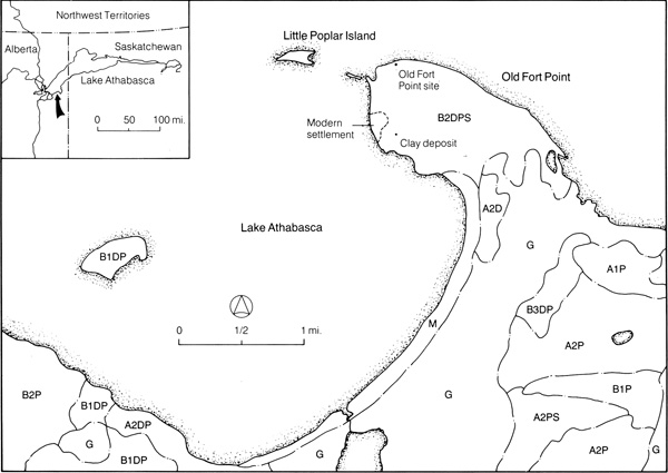
The site discussed in this report is located on Old Fort Point, a small peninsula at the west end of Lake Athabasca in the extreme northeast corner of Alberta (Fig. 1). The point is approximately 21 miles to the east-southeast of Fort Chipewyan, the nearest community, at latitude 58° 39' N. and longitude 110° 36' W.
The peninsula, approximately 0.75 miles wide and 1.75 miles long, juts northwest from the south shore of the lake approximately 6 miles to the east of the Athabasca River delta. A small, sheltered bay is located west of the point and Old Fort Bay, which is larger, is to the east. The land at the extreme northwest tip of the peninsula is very low and moist; dry land is just slightly above the level of the beach at an elevation of 701.97 ft. ASL (Canadian Engineering Services, Ltd., Bench Mark 36). From here, the land rises gradually toward the mainland, achieving an altitude of over 900 ft. ASL in a prominence about 0.75 miles east of the bench mark. The land is below 800 ft. ASL elsewhere on the peninsula. The Old Fort Point site is approximately 600 ft. east of BM 36, at an estimated elevation of 718 ft. ASL. It is on the crest of a gradual slope up from the west and 25 ft. to the south of the edge of a 15-ft-high steep bluff that forms a portion of the north side of the point (Fig. 2). The land continues to increase in elevation east of the site, while it slopes down toward a marsh to the southeast. Although the bluff is stable adjacent to the site — being overgrown with moss and trees — several old, narrow, slumped terraces indicate that erosion has taken place at some time in the past. The extent of erosional activity and its effect on the site, if any, are not known. A wide cobblestone beach extends to within 7 ft. of the bluff's base. Old Fort Point is situated in the southern fringe of the permafrost region at the transition between the Upper Mackenzie and the Athabasca South sections of the Boreal Forest Region of Canada (Rowe 1972: 44-5, 154). In the Upper Mackenzie Section, west of Old Fort Bay, white spruce (Picea glauca [Moench] Voss) and balsam poplar (Populus balsamifera L.) constitute the main forest cover on the alluvial flats bordering the rivers. Few other species occur although balsam fir (Abies balsamea [L.] Mill.) and white and Alaska birch (Betula papyrifera Marsh. and B. neoalaskana Sarg.) are prominent south of Lake Athabasca. On the benches above the flood plains an entirely different forest pattern exists. Here jack and lodgepole pine (Pinus banksiana Lamb. and P. contorta Dougl.), trembling aspen (Populus tremuloides Michx.), black spruce (Picea mariana [Mill.] B.S.P.) and tamarack (Larix laricina [Du Roi] K. Koch) predominate, while white spruce occurs only in minor quantities (Rowe 1972: 45). The soil cover in the section typically consists of deep deposits of glacial tills or more recently deposited lacustrine and alluvial materials overlying Devonian and Cretaceous bedrock. Gray luvisols and eutric brunisols are developed on well-drained sites in the Athabasca area, although immature profiles are more usual in alluvium (Rowe 1972: 45). The Athabasca South Section east of Old Fort Bay is characterized by jack pine, black spruce and tamarack. White spruce, trembling aspen and balsam poplar are uncommon except along river valleys and lake shores where there is good growth. The sandy soils are derived from the underlying sandstones (probably late Precambrian) by glacial action. Humo-ferric podzols, gleysols and organic (peat) soils are present (Rowe 1972: 44). On Old Fort Point itself, the forest cover is of medium density and consists of white spruce, jack pine, trembling aspen, balsam poplar, white birch and alder (Alnus sp.). Shrubs are represented by the common juniper (Juniperus communis L.), saskatoonberry (Amelanchier alnifolia Nutt.) and choke cherry (Prunus virginiana L.). Wild raspberries (Rubus sp.) and strawberries (Fragaria sp.) occur in scattered patches, and there are several species of flowers, including wild roses (Rosa sp.). Grass and moss grow in areas not choked with the omnipresent juniper bush. Willows (Salix sp.) and horse tails (Equisetum sp.) are common along the beach. In the vicinity of the site, the dominant growth on lower ground (to the west of the site) is trembling aspen, white birch and juniper. To the east, on higher ground, the dominant types are white spruce and birch with scattered jack pine. The site is located at an elevation where white spruce and jack pine first appear, and was probably chosen for a building location so it would be adjacent to a source of good timber. The soils are, for the most part, podzols consisting of Pleistocene and post-glacial sediments and are characterized by a distinct, leached, strongly acidic whitish or grayish Ae horizon underlain by a reddish Bf horizon in which accumulate oxides of iron and aluminum (Lindsay et al. 1962: 30, 33; Rowe 1972:164). The soil cover rests on Precambrian Athabasca Sandstone which forms a part of the Precambrian Shield (Lindsay et al. 1962: 33). The climate in the Athabasca Region is classified as dry subhumid (Rowe 1972:155). The average annual rainfall is 7.6 inches while the average annual snowfall is 44 inches. Average rainfall and snowfall are highest in July (1.8 inches) and November (9.1 inches) respectively (Canada. Department of Transport. Meteorological Division 1954: 20-21). The annual mean temperature in the area is -6.7°C. January is the coldest month with an average daily mean temperature of -23.9°C. The warmest month is July with an average daily mean temperature of 17.2°C. From November to April, the average daily mean temperature is below 0°C (Canada. Department of Transport. Meteorological Division 1954: 15). The prevailing wind in the vicinity of Old Fort Point is from the north and is frequently quite strong since there is nothing to break its force as it sweeps across the lake. Subsequently, the lake is usually choppy along the south shore and often unnavigable by small boats, swells over five feet in height not being uncommon. The area is also subject to sudden storms which can come up in a matter of minutes. On one occasion during the 1971 field season, the author witnessed the approach of a storm front from the northwest wherein the wind speed changed from perfect calm to an estimated 40 to 50 miles per hour in less than 15 minutes. Similar occurrences were also recounted by several local residents.
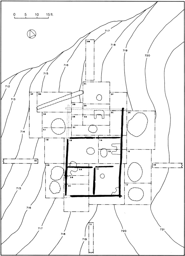
When the archaeological field party arrived, the Old Fort Point site was marked by eight depressions and three probable fireplace mounds which occupied an area approximately 45 ft. square. The area was overgrown with a dense stand of vegetation and had not been previously disturbed. After the site had been cleared, three test trenches were dug in what appeared to be strategic areas to recover a sample of artifacts which might shed light on the date and identity of the site as well as to obtain information concerning the orientation and size of the structure or structures involved. When this had been accomplished, the site was divided into horizontal units (Fig. 2) which would facilitate the recording of uncovered features and the assignment of artifacts to specific sections of the site for interpretative purposes.
Each horizontal unit was subsequently excavated stratigraphically in order to segregate recovered artifacts and structural components to determine if the site had been occupied more than once. Due to the shallowness of the overburden, the digging was performed using hand tools such as trowels, grapefruit knives and brushes from the start so that the recovery of cultural objects, faunal remains and structural features would be as complete as possible. To further facilitate the achievement of this objective, all flooring was removed after being recorded and the areas beneath were excavated to sterile subsoil. In addition, when small objects like beads and lead shot were encountered, the soil in their immediate vicinity was screened through both 1/16-inch and 1/4-inch hardware cloth to ensure the recovery of as many small items as possible. Screening of the fill at other times was not performed since the paucity of small objects during several trial periods when all soil was screened indicated that constant screening was not warranted. During excavation, all features and stratigraphic layers were recorded as they were uncovered so no information would be lost. To facilitate the comparison of the features at the Old Fort Point site with those described in historical documents and other site reports, all measurements were recorded in feet and tenths of feet. After the core area of the site (a single, large building) had been excavated, a trench was dug perpendicular to each side of the area in an effort to locate other features (Fig. 2). No evidence of any additional structures or occupation areas was uncovered in any of the trenches. The completion of these trenches marked the end of the project and the site was backfilled to return the area to as natural a state as possible.
Five major stratigraphic layers and numerous localized zones were encountered at the Old Fort Point site. The major layers were present in all or most of the excavation units; the localized zones were spatially restricted. Layer 1 Moss and decaying vegetal material (primarily juniper needles) comprised the uppermost layer which was 0.01 ft. to 0.5 ft. thick (0.14 ft. average). This detritus was deposited after the site fell into ruin and was overgrown with vegetation. Layer 2 Directly below layer 1 was a stratum of yellowish red and white sand which contained scattered charcoal, artifacts and lenses of both dark brown sandy clay and reddish brown sandy clay. This material was up to 1.65 ft. thick, averaging 0.48 ft., and originally covered the roof of the solitary building at the site. Layer 3 Under the sand was a discontinuous layer of dark brown sandy clay which contained small lenses of sand, charcoal flecks, fish remains, wood chips and birch bark. This stratum was up to 0.35 ft. thick, with an average of 0.22 ft., and constituted the material used to chink the roof of the building. This and the previous layer tapered out at a distance which varied from 4.5 ft. to 9.5 ft. to the north, east and south of the structure. To the west, where the ground sloped noticeably and erosion had washed the material downhill, the sand and clay terminated 18 ft. from the building. Layer 4 The fourth layer was a charcoal deposit up to 0.3 ft. thick (0.07 ft. average) which covered the sterile subsoil in the immediate vicinity of the building, and apparently represents overgrowth burned off prior to the construction of the structure. The charcoal tapered to a distance of 15 ft. to 25 ft. from the building on all sides, suggesting that an area only slightly larger than the structure was thoroughly cleared. Layer 5 Layer 5 was the undisturbed soil underlying the site, consisting of well-drained, white sand overlying yellowish red sand which rests on fine to coarse gravel. No clay was encountered, indicating that the clay used to chink the building was obtained elsewhere on the peninsula. The localized zones consist of pit fill and fireplace ash, and are described in the 'Description of Features' portion of this report. |
|||||||||
|
||||||||