|
Saint-Ours Canal National Historic Site
Lieu historique national du Canal-de-Saint-Ours
|
|
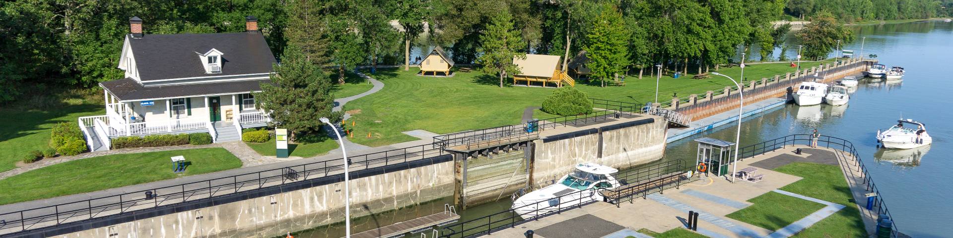 Parks Canada photo | |
|
Saint-Ours Canal National Historic Site of Canada is situated on the east bank of the Richelieu River, 52 km from Chambly and 23 km from Sorel Québec. It is located in a 5-hectare park and primarily consists of one enclosed lock between the east bank of the Richelieu River and Darvard Island, as well as a dam. The Saint-Ours canal is a place of relaxation and a resort that offers an exceptional setting as well as magnificent views of the Richelieu River. Recreational boaters, strollers and oTENTik campers flock to the site each year to take advantage of this unique setting. Le lieu historique national du Canada du Canal-de-Saint-Ours se trouve sur la rive est de la rivière Richelieu, à 52 km de Chambly et 23 km de Sorel, Québec. Situé dans un parc de 5 hectares, il est constitué principalement d’une écluse fermée entre la rive est de la rivière Richelieu et l’île Darvard, ainsi qu’un barrage. Le canal de Saint-Ours est un lieu de détente et de villégiature qui offre un cadre exceptionnel ainsi que des points de vue magnifiques sur la rivière Richelieu. Plaisanciers, promeneurs et campeurs oTENTik viennent nombreux chaque année pour profiter de cet environnement unique. Source: Parks Canada Website (2022) |
Established: 1987
For More Information Please Visit The OFFICIAL PARKS CANADA WEBSITE  Pour plus d’informations veuillez visiter LE SITE WEB OFFICIEL DE PARCS CANADA Quebec Québec |
Documents
Management Plan, Saint-Ours Canal National Historic Site of Canada / Plan directeur: Plan directeur, Lieu historique national du Canada du Canal-de-Saint-Ours (Parks Canada, 2021)
Public Consultation, Saint-Ours National Historic Site Draft Management Plan / Consultation publique, Projet de plan directeur du lieu historique national du Canada-de-Saint-Ours (Parks Canada, May 2021)
The Canals of Canada, Canadian Historic Sites: Occasional Papers in Archaeology and History No. 8 (John P. Heisler, Parks Canada, 1973)
saintours/index.htm
Last Updated: 01-Jan-2025