|
Mnjikaning Fish Weirs National Historic Site
Lieu historique national des Barrages-de-Pêche-Mnjikaning
|
|
 Parks Canada photo | |
|
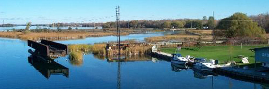
Mnjikaning Fish Weirs National Historic Site is located on portions of the bottom of the Narrows between Lakes Simcoe and Couchiching, a part of the Trent-Severn Waterway. This includes the navigable marked channel, the old channel that runs to the northeast and marshland surrounding these channels. The constriction of the Narrows allows fish to be caught as they move between the lakes, and the shallowness of the channel permits wooden weirs to be built there. The channel today is divided in two: the original channel curves to the northeast, and the navigation channel runs straight to the north. The navigation channel was first dredged in 1856-57, and dredging has also taken place in the original channel south of the junction. A linear island has been created along the eastern side of the navigation channel. A causeway for an old Canadian Pacific Railway bed runs across the north end of the narrows. Marshland lies in between these channels, and also east of the old channel. A third channel seems to have existed in the past, curving to the west of the navigation channel and it has been largely filled in by modern development. Le lieu historique national des Barrages-de-Pêche-Mnjikaning est situé sur des portions inférieures du défilé entre les lacs Simcoe et Couchiching, une partie de la voie navigable Trent-Severn. Il comprend le canal navigable balisé, l’ancien canal qui coule vers le nord-est et le marais entourant ces canaux. La constriction du défilé rend possible la prise de poissons qui se déplacent entre les lacs et la faible profondeur des canaux permet d’y enfoncer des pieux en fascines. De nos jours, le canal se divise en deux : le canal d’origine s’incurve vers le nord-est et le canal navigable file plein nord. Le canal navigable a été dragué en 1856-57, et le canal d’origine a aussi été dragué au sud de la jonction. Une île linéaire a été créée le long de la rive est du canal navigable. Une levée empierrée pour le lit d’une ancienne voie ferrée du chemin de fer Canadien Pacifique longe la portion nord du défilé. Des marécages occupent l’espace entre les canaux, de même que l’est de l’ancien canal. Un troisième canal semble avoir existé autrefois, s’incurvant vers l’ouest à partir du canal navigable et a été en grande partie comblé au fil du développement moderne. Source: Parks Canada Website (2022) |
Established: 1982
For More Information Please Visit The OFFICIAL PARKS CANADA WEBSITE  Pour plus d’informations veuillez visiter LE SITE WEB OFFICIEL DE PARCS CANADA Ontario |
Documents
Atherley Narrows Fish Weirs (R. James Ringer, extract from Underwater Cultural Heritage at Risk: Managing Natural and Human Impacts, 2006, ©ICOMOS)
The secrets of the Mnjikaning Fish Weirs (Laurie LeClair, from Anishinabek News, May 21, 2017)
The Mnjikaning Fishing Weirs — Wendy's Story 5:36 (Orillia, 2019)
mnjikaning/index.htm
Last Updated: 01-Jan-2025