Volume III
by W.F. Lothian
Chapter 6
Townsites and Subdivisions (1885-1973)
Introduction
Townsites and residential subdivisions have been an integral part of national parks in Canada since the first park unit was created. Although townsite development has been avoided in parks which have been established since 1948, the problems associated with the management of earlier urban areas still remain. The presence of townsites within national parks has frequently generated discussions about their merits, as opposed to characteristics that are undesirable in lands ostensibly intended for preservation in their natural state.
The Statement of National Park Policy adopted in 1964 regards townsites as partly, if not entirely, expendable. The policy statement reads in part:
"A townsite is an intrusion and should be permitted to develop in a park only if, by reason of the services it provides, the visitor is better able to enjoy the park for what it is.... A townsite, if required, should be developed provide the necessary services and recreations in accordance with the purposes of the park. It should not provide the extra entertainments and services common to urban living throughout Canada."1
Quite understandably, this view is not shared universally, especially by many residents and others carrying on business activities in the parks. Fundamentally, the subject remains controversial.
The reasons for the first park townsites generally were valid. Of the four established before 1915, three were on transcontinental railway lines. These were Banff and Field on the Canadian Pacific line, and Jasper, situated on both the Grand Trunk Pacific and the Canadian Northern Railways. Conversely, Waterton Lakes Townsite was miles from the nearest railway station. The townsites provided not only a base for the development of essential visitor services but also dwelling sites for those whose business activities or terms of employment required them to live in a park. Parliamentarians responsible for the establishment of Canada's first national park and townsite—Banff—had envisioned its evolution as a "spa", where the presence of thermal springs usually provided opportunities for many forms of business activity. On the other hand, Field in Yoho Park was a railway divisional point long before it was surveyed as a park townsite, and as such, it generated special problems.
Jasper Townsite was served for several years by two transcontinental railway lines. It was built around the Grand Trunk Pacific station of Fitzhugh, to which steel was laid in 1911. Two years later, the Canadian Northern Railway built a line through Jasper National Park which ran parallel to that of its competitor. Consequently, Jasper Townsite had to meet the needs of both railways and those of park visitors.
Early departmental files fail to disclose the basic reason for the survey and development of summer cottage subdivisions in the mountain parks. It does seem likely that these areas, which invariably were situated on a lake, were surveyed as attractions which would promote public use of the parks and focus attention on their scenic and recreational attractions.
Both seasonal and year-round residence in many parks was encouraged by the advertising of townsite and subdivision lots in populated centres outside park boundaries. As a result, the park townsites became resorts. However, in the intervening years, departmental policy governing residence has been changed. The privilege of leasing lots in summer cottage subdivisions was withdrawn in 1959. Furthermore, prospective residents of a park townsite must now establish, before attaining the status of citizens, a genuine need for their presence and for the services they propose to provide. In the following pages will be found an outline of existing and former townsites and subdivisions, and the circumstances of their establishment.
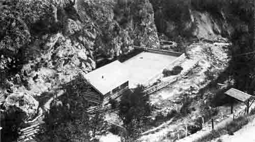
Radium Hot Springs pool after its acquisition by the National Parks Branch in 1923. The log dressing room building was replaced in 1928 by a frame building which was destroyed by fire in 1948.
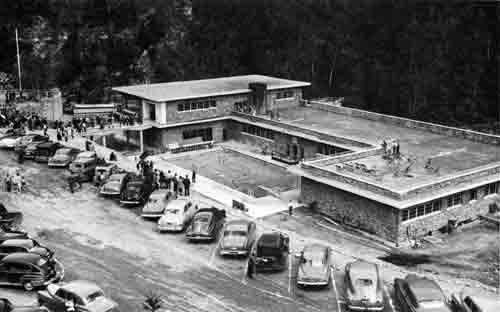
The Aquacort, opened in 1951, replaced the bath-house erected in 1928.
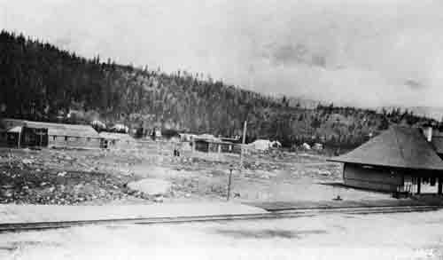
The building Townsite of Jasper in June, 1913. Prior to that year, it had been called Fitzhugh.
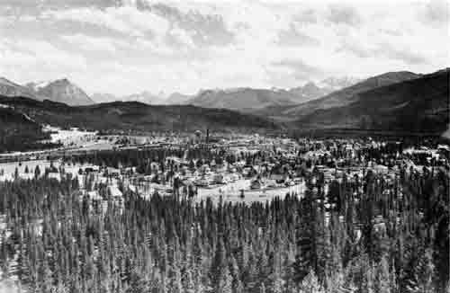
Jasper Townsite about 1963 — Fifty years after its survey.
Banff National Park
Townsite of Banff
The original settlement at Banff took form around the railway station, known as Siding 29. It was located about a mile and three-quarters east of the present station, where the road to the buffalo paddock crosses the railway. By 1885, the settlement included the Canadian Pacific Railway section house, another building providing overnight accommodation, two stores, a livery stable and several cabins or shanties occupied by squatters. David Keefe, who claimed to be the discoverer of the upper hot springs, operated a boarding house in the railway section house from 1884 to 1886.
The first survey of Banff Townsite in 1886 by George A. Stewart, D.L.S., has been mentioned in an earlier volume. The original plan of the town plot located north of the Bow River consisted of three residential blocks, A, B, and C, strung along the north bank of the river, and 19 additional blocks divided almost equally by Banff Avenue, for business and residential use. Banff Avenue had been extended easterly to provide access from the railway station, then two miles from Bow River bridge, and the settlement in the vicinity of the station had been incorporated in two blocks designated F and G.
Changes in the town plot later became necessary, mainly because a portion of the proposed townsite was leased to the Canadian Pacific Railway Company, and also to accommodate an expected growth in the local population. The C.P.R. lease had its origin in a supplementary land agreement dated March 3, 1886, between the company and the Government of Canada.2 Under the agreement, the company was entitled to select from vacant Dominion Lands as part of its land subsidy, not more than 160 acres adjacent to each of its stations located between the western limit of its land grant and the summit of the Rockies. Before the designated areas were surveyed, the Government had established Rocky Mountains Park, within which it was desired to withhold the granting of freehold titles. After negotiation, the railway company agreed to accept a long-term lease for the lands selected adjoining Banff Station. Although it was not completed until January 20, 1893, the lease covered a term of 999 years, the longest ever incorporated in a national park lease.3
Eventually, the dimensions and location of an expanded townsite were approved, and Plan "A", covering the portion of Banff north of the Bow River was approved by the Surveyor General at Ottawa on July 9, 1888. This plan incorporated the Canadian Pacific leasehold grant, which was shown thereon as Parcels A, B, and C. The villa lot section of Banff south of the Bow River was covered by two plans. One designated Sheet No. 1, dated October 24, 1888, was approved by the Surveyor General on November 6, 1888, and covered Ranges—now termed blocks—1 and 2, 12, 13, and 14, and part of Range 7. Sheet No. 2, dated June 8, 1889 and approved on October 16, 1889, incorporated the balance of the townsite between the Bow River bridge and the Upper Hot Springs. For the next 25 years, these plans formed the basis of all leasehold titles granted in Banff Townsite.
A sequel to the completion of the townsite plans, and the settlement of the Canadian Pacific Railway's current land problems, was the relocation in 1888, of Banff station to its present site adjoining the townsite. This move ended settlement around the original station at Siding 29. No titles or leases had been granted, and the squatters either moved into the surveyed town or departed for destinations outside the park.
Townsite Survey and Extensions
Difficulties in locating lot and block boundaries in Banff were being experienced by the Park Superintendent as early as 1903. This shortcoming was attributed to the surveyor's use of wooden posts, which had rotted out or disappeared. In 1912, following the establishment of the Dominion Parks Branch, Commissioner Harkin obtained authority for a resurvey of the entire townsite. By then, it was believed that few of the lots in the townsite had actually been laid out by permanent markers on the ground, although an excellent scheme of subdivision appeared on paper.4 C.M. Walker, D.L.S. was assigned to undertake the work. By 1914, Walker had completed a new plan of the townsite north of the Bow River, which was approved by the Surveyor General on July 29, 1914. The new plan extended the townsite easterly, and necessitated the opening and naming of seven new streets. In accordance with existing practice, these were given the names of Canadian animals, and gave rise to Cougar, Marmot, Antelope, Fox, Deer, Grizzly and Wolverine Streets.
In 1913, the Department engaged the services of T.W. Mawson, a noted town-planner and landscape architect, to examine Banff and make recommendations which would assist in its future development. His report, which appears as an appendix to the Commissioner's annual report for 1914, recommended townsite extensions, substantial revisions to existing street patterns and drives, and the construction of a number of new park buildings. In order to incorporate many of Mr. Mawson's recommendations, Mr. Walker's surveys were continued for several years. Later townsite additions included the Badger Addition (Blocks 36, 37 and 38 in 1915) and the St. Julien Addition in 1917. The latter incorporated 15 residential blocks on the western slopes of Tunnel Mountain, containing some very desirable dwelling sites. Much of this addition, excluding Blocks 38 and 39, is now held under lease by the University of Calgary for use by the Banff Centre for Continuing Education.
Squirrel Street Subdivision
A legal survey of a portion of the area held under lease by the railway company since 1893 had been made in 1924 to facilitate an exchange of land with the Crown. The exchange, completed in 1934, provided the park administration with a right-of-way through the railway property for the Banff-Lake Louise Highway, which had been opened in 1920. The Department also received title to what is now known as Railway Street, and to an extension of Lynx Street. In turn, the Canadian Pacific Railway obtained a freehold title to several small parcels adjoining its right-of-way for the purposes of station grounds.
Discussions between officers of the National Parks Branch and those of the Railway Company on the possibility of effecting an exchange of lands which would permit the former to regain control of the C.P.R. leasehold area were commenced in April, 1941. The completion of the Banff-Jasper Highway in 1940 was swelling tourist travel to the park, and a need for additional visitor accommodation was already indicated. In November, 1941, the Canadian Pacific offered to surrender, under certain conditions, its leasehold then containing about 120 acres, in return for a long lease covering the site of its Banff Springs Golf Course. This area had been taken over from the Crown in May, 1927 under a 20-year agreement, renewable for 10 years.
The Company's proposal was accepted in principle by the Department, but various considerations affecting the terms of a formal agreement, delayed completion of the transaction for several years. Eventually, a satisfactory basis of exchange was worked out between the Director, Lands, Parks and Forests Branch, and Railway Company's legal counsel, following discussions in Ottawa in April, 1947. The arrangements were confirmed by an exchange of letters between the Minister of Mines and Resources and the President of the Canadian Pacific Railway Company.5 Under the provisions of an order in council which authorized the exchange, the Company surrendered its leasehold on the condition that it be granted freehold title to an area of some 14 acres as an extension to its station grounds, together with a licence of occupation covering the site of the Banff Springs Golf Course for a term of 99 years. The order in council stipulated conditions affecting future use of the lands comprising Parcel A, south of the railway right of way. One condition prohibited its use as a site for visitor accommodation or recreational buildings.6
Following acquisition of title by the Department, a portion of Parcel A bounded by the railway, Lynx and Squirrel Streets, was subdivided by legal survey as Blocks 53, 54, 55 and 56. Lots in Block 55 and 56 were disposed of by public competition. Block 53 was reserved for the purposes of staff accommodation. The remaining Block 54, originally withheld from disposal, was placed at the disposal of the Banff School Board in 1956 for the erection of a new elementary school. The Board obtained a long term lease for the site in 1958.
Later Additions
Although a number of the larger lots in the townsite were re-surveyed into two or more building sites, no major additions incorporating residential sites were made to Banff from 1950 to 1964. Meanwhile, practically all lots suitable for the construction of dwellings were leased and the Department was subjected to strong representations by the Banff Advisory Council and by private individuals for the development of additional housing areas. In 1964, a subdivision survey along the north side of Cougar Street between Lynx and Fox Streets was authorized. The survey was completed in November, and the resulting Block 57 made available 26 lots. Of these three were reserved for church purposes, and the remainder were disposed of by public competition. Leases were restricted to "bona fide" citizens able to establish a need for accommodation by reason of the terms of their employment.7
An important re-survey and subdivision of lands already within the townsite, undertaken in February, 1966, is worthy of mention. The area comprised 20 lots and a small park area in Block 36, together with Block 38 and an adjoining area, which were shown on the plan of the Badger Addition of 1915. The resulting plan of the newly-created Block 63, incorporated 15 large lots ranging in size from .56 to 5.13 acres, to which access was provided by a crescent-shaped road from Cougar Street.8 Later, a Calgary landscape architectural firm — Man Taylor-Murat, was commissioned by the Department to carry out a housing study of Banff. Following a review of the consultants' report, which was received in March 1970, a further subdivision of portions of Block 63, together with Block 37, was made to facilitate the development of a housing area. The new plan gave rise to a new block 64, together with six parcels, CN, CO, CP, CQ, CR, and CS. A detailed plan for the development of the various parcels and lots in Block 64 subsequently was assembled in the office of the Director, Western Region, at Calgary.
Actual development of the new housing area was planned in three stages. The first consisted of 17 single-family detached houses in Block 64, facing on Marmot Place. The second stage envisioned a mixture of townhouses, garden courts and apartment buildings, while the third stage called for the construction of single- and two-family dwellings, detached homes, and garden court or townhouses. The 17 lots in Block 64 were released in August, 1970, and within two years were fully occupied by houses. Development of the second stage was awarded by tender to Nu-West Development Corporation Limited of Calgary. The company completed its first phase, comprising the construction of 37 townhouses and garden court units, all of which were sold. Nu-West however, backed out of the second phase of this stage, which was to provide for the construction of 55 to 60 apartment units.9 Later, the proposed development of apartment units was discarded in favour of some 30 additional townhouse and garden court units for sale or for rent. Tenders were called for early in 1973 for the right to complete a revised second phase of Stage 2. Additional development in future also was contemplated.
Storage Lots Created
The early development of Banff Townsite north of the Bow River was carried out without benefit of planning or zoning. As the population increased and original buildings were replaced by improved structures, a number of undesirable features in the form of horse stables, coal and wood yards, and ice-houses remained as incongruous relics of an earlier economy. A census and survey of the townsite undertaken by the Chief Inspector of National Parks in 1937 disclosed numerous violations of park regulations, the existence of many unauthorized storage buildings, and on some lots, property deterioration to a slum condition.
In 1938, the Park Superintendent recommended the survey of a special area for the accommodation of wood and fuel depots, stores buildings, and equipment and supplies used in construction. An industrial site between Cougar Street and the railway line west of the Badger Addition was surveyed by a park engineer as Block S. It contained 12 lots. These lots were made available to Banff businessmen under permit at a nominal rent.
An increasing demand for this type of quasi-business lot led to the expansion of the block, which, by 1951, contained 21 lots or parcels. In that year, authority was obtained from the Deputy Minister to increase lot rentals and to replace permits by licences of occupation.10 Action, however, was deferred until 1953, when a resurvey of the area was made. It provided an improved layout and made available a total of 28 lots. Short term leases, expiring in 1960, were then issued to lot-holders.
Up to 1960, services available to leaseholders were limited to an access road from Fox Street, and electricity. A need for additional services considered necessary to relocate additional business enterprises, including a milk distribution depot, prompted the Park Superintendent to recommend another expansion of Block S and the provision of water and sewer services. A longer term of occupation under lease also was suggested. These proposals were approved at departmental level and a legal survey undertaken by a Dominion Lands Surveyor resulted in an expanded block S incorporating 39 lots. The Deputy Minister authorized the granting of 21-year leases, subject to adoption of an increased scale of rentals, to be reviewed in 1970. The new leases contained terms and conditions that restricted their issue to individuals operating a business within the park, and excluded use of the premises for personal residence or for the accommodation of others.
A study of Banff undertaken in 1961 by a Vancouver town-planning consultant, Dr. H.P. Oberlander, sparked plans for redevelopment of the townsite, including provision of additional sites for residential construction. The area occupied by Block S was first recommended by Dr. Oberlander as a site for tourist rental accommodation, but later studies indicated that it was more suitable for the expansion of existing residential areas.
Consequently, the Superintendent in August, 1964, recommended the relocation of Block S to a new site east of Marmot Street, between Highway 1—A and the Canadian Pacific right-of-way. Later, the Director of National Parks accepted a recommendation of Dr. Oberlander that a site north of the railway line adjacent to the Park Industrial Compound would be preferable. A legal survey, completed in June, 1965, resulted in a well-designed area consisting of five blocks, 58 to 62 inclusive, containing a total of 72 lots.11
Subsequently, the Minister authorized the leasing of lots in the new area for terms of 21 years, at an increased rental, which would be subject to review in 1970. The Superintendent was given authority to negotiate with lease-holders desiring to relocate their business from the existing Block S to the new industrial site. Any lessee planning relocation would be eligible for compensation based on the appraised value of existing improvements, and the cost of relocating or rebuilding. By the end of 1972, more than a dozen lots had been leased for new developments, and several lease-holders were relocated. In addition, a study of the Banff and other national park industrial areas in the western region was undertaken by the Regional Director. It was expected that the study would help determine the character of and priorities for the type of operation to be located in storage and service areas.
Townsite Development
Earlier in this history, the development of Banff Townsite was briefly mentioned. In the following paragraphs, additional details of major works or buildings undertaken or erected by the National Parks administration will be recounted.
Administrative Headquarters
During the summer of 1886, George A. Stewart, the park's first superintendent, carried on his survey work from a tent located a few yards from the original railway station, Siding 29. By early 1887, a new office, constructed of hewn logs, had been opened on Bear Street—Lot 22 in Block 1. It was built by local workmen from logs transported from the Castle Mountain area. In 1888, the Superintendent shared half of the building with Banff's first school teacher, Andrew Gilmore, pending the construction that year of the embryo town's first school.12 The Bear Street office served as park headquarters until July, 1903, when the Superintendent occupied the ground floor of a new museum building erected on Banff Avenue near the north end of Bow River Bridge. The original office was sold, and after being utilized for a variety of purposes, it was demolished in 1948.
The Banff Museum building contained the park administrative offices for the next 33 years. In 1935, funds were provided under the Public Works Construction Act for a new administration building. On completion in 1936, it provided accommodation not only for the Superintendent and staff, but also for the town post office, customs office, and the Department's construction and engineering services. Built of Rundle limestone, it occupied the site of the former Bretton Hall Hotel, and commanded a view of Banff Avenue northerly to Cascade Mountain.
Although construction of a residence for the Park Superintendent was commenced in 1889, the building was never occupied for that purpose. Before completion, the Department decided to use it for a museum. In 1894, the building was moved to a site immediately south of the Bow River Bridge, and, after installation of display cases, was opened to the public in 1895. All exhibits were moved to the new museum in 1903, and the old building was sold as a dwelling. The site is now occupied by a restaurant.
Now an architectural curiosity, the Museum Building has housed mammal, bird and mineral exhibits for seventy-five years. Finished in British Columbia fir, it was a show piece more than half a century ago. It featured a public reading room where, the Superintendent's annual report related, "visitors could read the nation's daily papers and write letters on note paper emblematic of the park".13 The emblem was the embossed image of a Rocky Mountain sheep. Over the years, the displays have undergone periodical revision, and the need of a new natural history museum has long been recognized. A lack of funds for such a project however, has confined the museum operation to the 75-year old structure.
Eventually, the Park Superintendent occupied an official residence. It was built in 1912, and occupied two large lots on Buffalo Street overlooking the Bow River. In 1920, this building was dismantled and a new residence constructed, with the interior finished in fir. It served successive superintendents and other officers of the park for more than 50 years. A modern one-storey house, erected on Kootenay Avenue in 1970, provided accommodation for the Park Superintendent until 1977, when occupation of the older dwelling was resumed.
Town Streets
Early expenditures on municipal services in Banff included the clearing and grading of town streets. Until 1912, most thoroughfares were dirt roads or at best, gravelled. During 1912-13, the main route from the railway station to Banff Springs Hotel, involving a portion of Banff Avenue was improved by the installation of a surface described as "rocmac". Most likely, this was a type of the popular macadam surface, produced with the aid of a rock-crusher and a steam roller. From 1919 on, the use of asphalt as a binder was employed in surfacing streets. Between 1957 and 1961, the town's main thoroughfare, Banff Avenue, was given a "new look". Reconstruction of the roadway from Marmot Street to the Bow River Bridge was undertaken following the replacement of sewer and water lines. Power cables for street lighting were installed underground and public utility companies cooperated in the installation underground of telephone and gas services. A median strip was installed to help regulate traffic, sidewalks were replaced as required, and traffic lights installed at four key street intersections.
Reconstruction of Spray Avenue from Bow River Bridge to the Banff Springs Hotel was also carried out from 1959 to 1961. A new approach to the business section of Banff from the railway crossing west of the station to Lynx Street was opened in 1965. This improvement, involving 600 feet of paved roadway, crossed the parkette area south of Railway Street.
Water and Sewer Services
Residents of Banff first obtained their domestic water supply from wells or from dealers who delivered it in barrels from the Bow River. The first water and sewer services were installed in 1905 and 1906. The original system drew its supply from a reservoir created by the construction of a small dam on Fortymile Creek at an elevation of 315 feet above the town. The water was carried by a 12-inch wood-stave line to the townsite and distributed from a 10-inch cast iron main. A new dam was built in 1911 and enlarged again in 1913. In 1914, a new water system with new intake works was installed.
An increased demand for water necessitated the construction of a new dam on Forty Mile Creek in 1949, which increased storage capacity to 20,000,000 gallons. Chlorination of the water supply was commenced in 1947, and in 1959, an automatic chlorinator replaced the original equipment. A major water service extension was made in 1962 to the Upper Hot Springs bathhouse, with extensions to the Rimrock Hotel and the Sulphur Mountain gondola lift. A water main serving Tunnel Mountain campground was installed in 1965, and the following year, water and sewer mains were extended to the townsite industrial area north of Banff Avenue.
For years, the town sewage was discharged without treatment into the Bow River near the falls. This regrettable pollution of one of the park's main streams existed for more than 60 years. Remedial steps, however, were taken in 1971 when the treatment of sewage by lagoon aeration was commenced. Town sewage is now conveyed by mains to a sewage lagoon constructed on the south bank of Bow River at a point east of the Banff Springs golf course.
Electric Power Service
Banff residents said goodbye to kerosene lamps in 1904 when the Department of the Interior made arrangements to purchase electric power from the Canadian Pacific Railway Company. The railway company in turn drew on the power plant operated by its subsidiary, Pacific Coal Company at Bankhead, three miles northeast of Banff. The town's first street lighting was installed at this time.14
Following lengthy strikes by the miners in 1919 and 1921, the Canadian Pacific decided to close down the operations of its Pacific Coal Company. Prior notice of this action was given to the Department of the Interior, with the advice that it would not be possible to continue a supply of power to the Town of Banff. Consequently, the Department decided to develop power from water stored at Lake Minnewanka. When Calgary Power Limited was permitted in 1912 to raise the water in the lake, provision had been made in the dam for a "thimble" through which the natural overflow might be used in future if desired. Work on a power plant and accessory works was commenced in December, 1922, and during the period of construction the operation of the Bankhead plant was continued. A transmission line from the powerhouse to Bankhead was constructed, and the existing distribution system from that point to Banff was taken over by the Department.
Operation of the Cascade River power plant was continued until 1942. Under authority of the War Measures Act, Calgary Power Limited received permission to increase the water storage facilities of Lake Minnewanka and to construct a hydro-electric generating plant at Anthracite on the Calgary-Banff highway to augment existing energy for war industry in Calgary. Work on the project was commenced early in 1941, and by November, 1942, the company had completed construction of a 1900-foot earth-filled dam, a power canal from the lake to a point near Anthracite, a penstock, and a powerhouse. By arrangement, Calgary Power Limited took over the distribution system in Banff in November, 1942, and commenced full-time operation of its new powerhouse on December 1 of that year.15
Departmental Buildings
Until 1913, most of the buildings utilized in providing municipal services in Banff were of log or wood construction, old fashioned, and moderately functional. That year, additional appropriations obtained by the Commissioner of Parks permitted the construction of brick stables at Squirrel and Elk Streets, and a new stores building on Bear Street. The building boom also included a new brick detachment building for the Royal Canadian Mounted Police, adjoining the park museum on Banff Avenue. Another structure, destined to remain a landmark for many years, was a fish hatchery constructed by the Department of Fisheries on Spray Avenue, not far from the Banff Springs Hotel.
Departmental installations completed later included a garage erected on Bear Street in 1920, and a one-storey building on Cariboo Street erected in 1935 for the maintenance of the mechanical equipment used by the Engineering Service on highway construction projects. This building was turned over to the park administration in 1938 and for the next 20 years was utilized as a central garage. The building erected for stables in 1913 was converted to the storage of park warden equipment. In 1955, local telephone service was taken over by Alberta Government Telephones, on completion by the Provincial Government of a modern automatic exchange building on Beaver Street. During the year following, the Department of Public Works erected a new federal building on Buffalo Street, in which accommodation was provided for the local post office, and the staff of the Public Works Department.
Work Camp and Maintenance Compound
Steps were taken in 1949 to develop a Government work camp and maintenance compound outside the townsite, with the object of clearing townsite lots utilized for semi-industrial services. A site was selected east of the town and north of the Canadian Pacific Railway, to which access was provided from Banff Avenue by a level crossing installed at the north end of Marmot Street. A number of surplus buildings from a former prisoner of war camp at Seebe was transferred to the site and converted to the uses of bunk-houses, various trades shops, and staff quarters. A large kitchen-dining hall, with full basement, was erected in 1954 and opened for use in 1955. Recreational facilities for staff were made available in the basement.
In 1957, appropriations were obtained for the first unit of the maintenance compound, to which water, sewer and gas services had been extended in 1954. The new building—a mechanical workshop—containing complete garage facilities, was occupied in 1958. A second major unit was added in 1960-61, in the form of a service station building, which incorporated a modern vehicle paint shop. Completion of this building permitted the removal of all gasoline-dispensing services from the stores area on Bear Street. A new central stores building was erected in 1963 in the compound.
These installations led to the renovation of the former garage building on Cariboo Street which was converted to a fire hall, with integrated office and storage space. In turn, the former fire hall, originally the first public school, together with the old stores building on Bear Street, were demolished and the sites converted to public parking.
Other Building Construction
Banff's first hospital was contained in the Sanitarium Hotel complex opened in 1887 by Dr. R.H. Brett. A growing population, however, required expanded facilities, and the first Mineral Springs hospital, then called the Brett Hospital, was constructed in 1910 in Villa Block I. Operation of this institution passed to the Sisters of St. Martha, and the original buildings were replaced in 1956 by a modern structure.16
Banff's detachment of the Royal Canadian Mounted Police for many years was accommodated in what were termed 'temporary' buildings. Finally, in 1913, new barracks, constructed of brick, were opened on a site adjoining that of the Museum Building which then contained the Park Superintendent's office. This site served the Police until 1966, when a new detachment building was constructed on a site provided in the Parkette area at the corner of Lynx and Railway Streets.
The business area of Banff Townsite comprised mainly the blocks on both sides of Banff Avenue north of the Bow River Bridge to Moose Street. From the 1950's on, many of the older buildings in this section were either modernized or replaced. Other than hotel and gasoline service stations, the most notable structures erected included the bus depot of Western Canadian Greyhound Lines at Cariboo and Beaver Streets in 1948, and the Garbert Block on Banff Avenue in 1959. Banff's first super-market, operated by Safeway Stores, opened its doors on Bear Street in 1964. The first two large apartment buildings in Banff were erected in 1960-61.
Saddle-horse Concessions
In early years, visitors to Banff depended on horses for local transportation. Local sight-seeing was carried on with the aid of a large high-sprung vehicle known as a "tally-ho", which carried up to a dozen passengers. Buggies, democrats, and saddle horses also were available at the numerous liveries in town. The advent of the automobile however, reduced the number of horse-drawn vehicles gradually to zero, but the popularity of the saddle horse as a recreational adjunct remained.
The saddle-pony concession at Banff Springs Hotel was a continuing attraction for more than half a century, and its operation in later years had been carried on by members of the Brewster family. Most horse liveries in the downtown area had disappeared by the 1950's, but one on Bear Street, owned by Isaac Mills, had remained. The operation of livery stables in the Villa Lot section of the townsite, south of the Bow River, had been tolerated for many years. The Canadian Pacific Railway stables, although operated by the company until 1906, had been leased by Brewster Transport Limited. Over the years, the buildings, which incorporated a bunk-house and mess hall, had deteriorated to the nuisance stage.
Attempts by park authorities to relocate the stables went back to 1921, but not until 1957 were effective measures taken. That year Superintendent Strong, after consultation with Canadian Pacific officers and livery operators, obtained agreement to a move of all town livery operations to a site once occupied by a defunct gun club west of the Bow River. Livery lots were surveyed in 1958, and the two operators in the Villa lot section of the townsite, Claude Brewster and William Martin, were granted leases and permits to erect small corrals and buildings.
The Mills operation was continued on Bear Street until 1964 when the business was sold. The new owner, Thomas Boon, agreed to a relocation in the new livery lot area, and commenced operations there in 1965. The relocation of the saddle horse concessions had the unqualified approval of the Banff residents. The new site, served by an access road and a parking area developed by the Park Superintendent, also found favour with visitors. The old railway company stables on Spray Avenue were demolished and the site was acquired by the Crown.
Banff's Churches
Churches were among the first major buildings in Banff townsite. Superintendent Stewart recorded in his annual report for 1887 that members of both the Methodist and Roman Catholic faiths had erected churches, and that the Anglicans and Presbyterians were holding weekly services. All four denominations eventually completed church buildings in prominent locations.
In 1951, the Roman Catholic Church authorities surrendered their lease of property on Lynx Street, and obtained a new site at the corner of Lynx and Squirrel Streets. The handsome stone building erected in 1952 was enlarged in 1964. In 1925, the Methodist Church entered church union, and the building has since been known as Rundle United, after the pioneer Methodist missionary, Robert Rundle. A substantial addition was made to the Anglican Church in 1958.
A lack of suitable building sites inhibited, for many years, the erection of church buildings by members of other sects. The survey of Block 57 in 1964, however, afforded opportunities for expansion when three parcels were made available as church sites. They are now occupied by the Mormon, Park and Pentecostal churches.
The School System
The development of Banff's school system forms an interesting part of the town's history. The first permanent school building on Banff Avenue was completed in 1888, and was occupied until 1913. That year, the Department provided the local school board with a new site on Block "E" in the angle of Elk and Wolf Streets, on which a substantial brick building was built. The Superintendent took over the old school building in November, and by the Spring of 1914, had completed alterations that provided space for a fire hall, an engineering office, and after 1921, the local telephone exchange.
A growing junior population in Banff led the Banff school board to acquire the south half of Block 14 adjacent to the existing school on which a new elementary school containing six classrooms was built in 1924. The older school building was then converted to the uses of a high school. The need for a community hall and additional classroom space induced the rate-payers in Banff to approve the financing through taxes of a suitable building. This was erected in 1939 on two vacant lots on Banff Avenue adjoining the fire hall. Faced with Rundle limestone, it contained an auditorium capable of seating 500 persons, and several classrooms.
A burgeoning town population after World War 2 found school facilities inadequate. Moreover, provincial regulations called for an area of approximately six acres to meet the requirements of a new school having 12 to 14 rooms. In 1955, the only vacant site in town that met requirements was Block 54, comprising a portion of the lands acquired by the Department in 1952 from the Canadian Pacific Railway and later surveyed as a residential subdivision. After negotiation, this block, containing 16 lots, was made available to the School Board for the construction of a modern elementary school, which was completed in 1957.
The latest addition to the town's school system was made in 1962, when a composite two-storey high school was built on the site of the former elementary school in block 14. This building incorporated a combined gymnasium and lecture hall, metal and wood-working shops, and a chemical laboratory. The original high school was razed and the site used in winter for an open-air skating rink. In summer, the rink doubled as a public parking lot.
Completion of the new schools in 1962 left the School Board in possession of the Banff Avenue auditorium, which was no longer required. It was offered to the federal government, and, as it was situated within an area recommended by the Banff Urban Development plan as a civic and interpretation centre, authority for its purchase was obtained. Following its acquisition by the Department in 1966, it was rented to the Banff School of Fine Arts on a year to year basis.
Banff Archives and Library
Banff's cultural resources were broadened in 1968 following the construction of a building to house the Archives of the Canadian Rockies. Conceived and financed by a public-spirited citizen of Banff—Mrs. Catherine Robb Whyte—the development was planned to include a modern library, an archives, and an art gallery. Utilizing as a core, properties in which the Whyte family had owned a leasehold title for years, Mrs. Whyte assembled additional lots between Bow Avenue and Bear Streets for the archives development. It is controlled and managed by the Peter Whyte Foundation, with registered headquarters at Banff.
Plans and proposals for the library-archives development were discussed exhaustively in advance with officers of the National and Historic Parks Branch to ensure that they would conform to zoning and planning proposals for Banff. The actual building plans, prepared by a Calgary firm of architects, provided for a floor space of 15,000 square feet. The building, 150 feet in length, combines stone and redwood, topped by a copper roof, to present a very attractive exterior. Supervised by a qualified archivist, the archives is being developed as a repository for papers, books, photographs, records and artifacts pertaining to the Canadian Rockies and adjoining areas. Eventual extension of the existing grounds by the inclusion of additional properties controlled by the donor is contemplated. These extensions will permit strategic relocation of two small and one medium size buildings of local historic interest that presently are on the site.
Banff Centre for Continuing Education
The Banff Centre, originally established as the Banff School of Fine Arts, is one of the most interesting developments in the Townsite. Although a non-conforming institution in the park—in relation to National Parks policy adopted in 1964—the School has emerged over a period of 40 years as an outstanding attraction for visitors. It offers a variety of courses in fine arts during the summer season and a program of business management studies extended over the year. By reason of the School's location, patrons also may enjoy the numerous scenic and recreational attractions of Banff National Park.
The School was sponsored by the Extension Division of the University of Alberta, with the aid of a grant from the Carnegie Foundation, provided over a period of three years. Summer classes were initiated during 1933 under the direction of Dr. E.A. Corbett in theatre and drama, utilizing the old Bretton Hall theatre and classrooms of the Banff School Board. An art course was added in 1935 and later tuition in singing, creative writing, and instrumental music was made available.
In 1940, the School obtained the use of a new auditorium erected by the Banff School Board on Banff Avenue, where classes in weaving, ceramics, and leathercraft were conducted. Registration increased rapidly over the next 10 years and in 1944, the National Parks Branch helped meet a demand for student accommodation by leasing to the University a site on Cougar Street for the erection of temporary dormitories developed from surplus wartime buildings.
In 1945, the University sought assistance from the Department of Mines and Resources in obtaining a permanent site for the future development of the School of Fine Arts. Following an examination of potential locations, the Department in 1946 leased to the Governors of the University, part of the St. Julien subdivision on the west slope of Tunnel Mountain, and reserved additional lots for future use. With financial assistance from a resident of Calgary, Mrs. J.H. Woods, the School erected between 1947 and 1949, three large chalets containing living quarters and instructional facilities for students. The central core of a large administration building designed to accommodate an auditorium, dining room and other features was opened in 1953. Additional wings were added to the building in 1958 and 1962, and Chalet IV was built in 1960.
Accommodation and classroom space provided by the new buildings failed to meet the demands of an increasing number of applicants for courses. Consequently, the School facilities were expanded by the purchase or lease of buildings at other locations in the townsite. In 1952, a School of Advanced Management was inaugurated to provide executive training for aspiring businessmen. Courses in this field, originally given during the winter season, were expanded to provide training throughout the year. Summer sessions in fine arts also were broadened to embrace language training, photography, ballet, and several categories of musical education. Much of the success attained by the School was due to the efforts and organizing ability of Donald Cameron, who succeded Dr. Corbett at Director of the School in 1936. Dr. Cameron was called to the Senate in 1955, but continued to direct the School until 1969.
By 1960, the continuing growth of the School's facilities in the absence of any comprehensive plan for future development, coupled with evidence of inadequate facilities for adequate fire protection, was a cause of deep concern to the National Park administration. Water pressure in the campus area was well below requirements and impending construction by the School necessitated the installation of an improved water distribution system including a reservoir capable of providing sufficient pressure for present and future requirements. The director was requested to provide details of the School's future development program within the limits of the land presently held under lease. Dr. Cameron complied to the extent of submitting a tentative program of expansion for the period 1961 to 1965. This program envisioned an expenditure of about $3,000,000 on three additional residential buildings, an auditorium, studio building, gymnasium and an additional wing on the administration building.
The water supply problem was solved following the engagement of a professional consultant, who recommended installation of an elevated reservoir and a new distribution system. The governors of the University of Alberta agreed after negotiation, to share the cost of the installation, with payments extended over a five-year period. The new water system was installed in 1963, along with a sewer line intended to serve a block of seven lots made available to the Centre that year for the erection of staff dwellings. In September, 1963, the director made a formal application for an extension of the School's land holdings but action on the request was withheld until a firm long-range development program was made available to the Department.
A proposed expansion of the School's activities came to light in 1964, when Calgary newspapers carried news items indicating that a boys' preparatory school might be developed to utilize some of the buildings during the off-season. An exchange of correspondence between the Minister of Northern Affairs and Senator Cameron, the School's director, disclosed that such a proposal was indeed under consideration. It was explained by Senator Cameron that a residential school for boys, to be affiliated with one in Wales, was proposed. It would be accommodated in existing residential buildings and classrooms and would be self-supporting. Honourable Arthur Laing, the Minister, however, made it clear that a proposal of this nature was not acceptable. He explained that not only was the development of a private school in a national park objectionable, but also that encouragement of such a proposal would result in requests for similar privileges in other parks. Senator Cameron appealed to the Prime Minister for support, but Mr. Pearson's reply confirmed the stand taken by his Minister.
In August, 1964, the long-awaited long-range development plan for the Centre was submitted to the Department by Senator Cameron. It covered the period from 1964 to 1970, and called for an expenditure of $2,400,000. A site plan accompanying the submission indicated a need for additional land on which to accommodate a new residential chalet containing 200 rooms; a combined auditorium, theatre and music building; a studio building and a gymnasium incorporating a recreation hall and swimming pool.
The request for an addition to lands already held under lease was given favourable consideration. A revised site plan, developed in the National Parks Branch, was reviewed by the Park Superintendent with Senator Cameron and was accepted. A formal offer of an enlarged campus was then made by the Minister to Senator Cameron early in 1965. The offer however, required the surrender of existing leases held by the University and agreement that the enlarged area containing 41 acres would constitute the maximum land area to be made available in future.
On acceptance of the proposal by the Governors of the University, the enlarged site was re-surveyed in 1966 as two parcels, divided by a diversion of St. Julien Road. A new lease, completed on May 16, 1967, stipulated the extent to which future development would be permitted and also set out the uses to which the lands and buildings might be devoted in future.
Development of the School was continued and four staff residences were built in 1964. During the year following, Chalet "V"—since named Rundle Hall—was erected, and in 1966 a wing was added to the building. A dining-room addition was made to the Administration Building in 1967. Construction of a theatre-arts centre was commenced in 1968 and the initial phase was completed that year. In 1969 an extension to this building, planned to contain 16 studios, classrooms and conference rooms, was undertaken and completed the following year.
Pursuant to the provisions of the Universities Act of Alberta, the Banff School of Fine Arts in 1966 became a constituent part of the University of Calgary, and the new lease of the School grounds was drawn in favour of the Governors of that University. Following the resignation of Senator Cameron as Director in 1969, his associate director of operations, Donald F. Becker, carried on as acting director. A successor to Senator Cameron was appointed in 1970, in the person of Dr. David Leighton of the University of Western Ontario, who had an impressive record in the field of business administration.
A further change in the status of the Banff School of Fine Arts occurred in 1970 when an amendment to the Alberta Universities Act constituted the School as a public trust of the University of Calgary "to be exercised in pursuit of the object of providing to the public of Alberta and beyond the boundaries of the Province the opportunity of access to a broad range of learning experience with emphasis on the creative arts and recreation related to the natural environment."17
The Act also provided for the appointment of a council of 14 members by the Lieutenant Governor in Council, one member of which would be nominated by the Minister of Northern Affairs and Northern Development for Canada. Subsequently, J.I. Nicol, Director of the National and Historic Parks Branch, was nominated by The Hon. Jean Chr�tien for the appointment. The Council's prerogatives include the appointment of a Director of the School responsible to the Council; the staff of the School; and the preparation, establishment and operation of programs, workshops and seminars. The council also is responsible for development plans and related capital and operating estimates for five-year periods and for the preparation of annual budgets and annual proposals for capital expenditures.
New Development Plan
In September, 1969, the University of Calgary, through its solicitor, requested permission to subdivide a portion of the lands held under lease for the School of Fine Arts, in order to facilitate the financing of several proposed new buildings. Approval of this request, however, was withheld until the University was in a position to submit for Departmental approval, a satisfactory plan for the future development of the School. Permission, however, was granted for the construction of a new residence on the campus for the accommodation of the Director.
A plan for the development of the Centre over a five-year period was received by the Director of the National and Historic Parks Branch in February, 1972. The plan and supporting data reviewed development and achievements to date, and outlined proposed activity in the field of fine arts, management studies and as a conference centre. The plan also forecast a construction program involving improvement or extensions to existing structures and the erection of new ones, entailing capital expenditures in excess of $4,500,000.18
Although the development plan for the School for 1972-1977 was drafted as a document for discussion, its contents pointed to a distinct change of role in the future. Its goals implied a transition from a school of instruction at the introductory and advanced levels of the fine arts to an institution of wide renown in the field of continuing studies, with a very wide range in programs. The significance of this change in the role of the School was identified by a change in name from the Banff School of Fine Arts to that of the Banff Centre for Continuing Education. This change was brought to the attention of the Park Superintendent in November, 1971, by Donald Becker, the Associate Director. In advising the Superintendent that the Centre now incorporated the School of Fine Arts, School of Management Studies, and Conference Division, Mr. Becker stated that the change of name in no way inferred that the Centre's attitude to fine arts was being diminished, and that the new title more correctly described the activities under way at Banff.
Discussions between the Director, National and Historic Parks Branch, and senior officers of the Centre confirmed the concern of the Branch that the present function of the Centre might be altered to that of a management training centre—a role never contemplated when its establishment was approved. Consequently, the proposed development plan of the Centre is under careful review by Parks Canada, the federal department responsible for national park administration, Indian Affairs and Northern Development.
Banff Recreational Centre
Winter sports including skating and curling were carried on in Banff prior to the turn of the 20th century, but facilities for these pastimes eventually became obsolete. Skating was confined to an outdoor rink, and a covered curling rink constructed in 1922 had few amenities. By 1955, Banff residents were planning for a civic centre that would contain not only an indoor skating and hockey rink and a modern curling rink, but also would serve as an auditorium and convention centre. Realization of these proposals presented problems, because the Townsite of Banff was not a municipality in the accepted sense, but an integral part of Banff National Park. As land in the townsite was crown-owned and occupied under lease, normal opportunities for financing a quasi-municipal project were lacking.
Request for Assistance
Early in 1956, the Banff Chamber of Commerce solicited financial assistance from the Minister of Northern Affairs and National Resources, the Honourable Jean Lesage, in developing a suitable civic centre. In reply, the Minister indicated a sympathetic interest in the proposal, on the understanding that any development undertaken could be used to stage sporting events of national and international importance. In February, 1957, Mr. Lesage offered to approach his colleagues in the Cabinet with a proposal that the federal government finance a civic centre and assume one half the cost, provided suitable acceptable arrangements for management and maintenance could be made.
In June, 1957, a change in federal government occurred, but negotiations between a local committee and the Department of Northern Affairs continued through 1957 and 1958. In December, 1958, the Minister, now the Honourable Alvin Hamilton, submitted to the Cabinet a recommendation that the government assist the citizens of Banff in realizing their objective. As proposed by Mr. Hamilton, the estimated cost of the centre, approximately $600,000, would be met by an outright grant of $l50,000, together with a loan of 50 per cent of the cost, or $300,000, whichever was the lesser amount. As proposed, the offer would come into effect upon presentation of evidence from the management group that it had raised the balance of 25 per cent or $150,000, from private sources.19
The submission was neither approved or rejected by the Treasury Board. Support for the proposal was extended by Eldon Woolliams, M.P. for Bow River, and by Senator Donald Cameron of Banff. Eventually, in November, 1959, the Treasury Board authorized the Minister, Mr. Hamilton to enter into negotiations with the management group which had succeeded the Banff Chamber of Commerce as sponsor.20 Under arrangements proposed by Mr. Hamilton, the government would be prepared to absorb the expense of an architect's fee for the design and plans of the proposed centre, such plans to include capacity in the ice-making plant for the later addition of a skating rink. The Government also would build the curling rink portion, subject to approval of design, and on the understanding that the management group would be responsible for the provision of the ice-making and other mechanical equipment and furnishings required for the building. The government would then lease the building to the management group at an annual rate of rental sufficient to cover the amortization of the government's investment over a 20-year period, with interest calculated at the government's borrowing rate. A lease of the site for a term of 42 years was contemplated.
Curling Rink Constructed
The management group, which was incorporated in May, 1960 as Banff Recreational Centre, accepted the proposal, and indicated its desire to proceed with the construction of a curling rink accommodating eight sheets of ice. The estimated cost of such a building originally was $200,000, but was increased later to $225,000, owing to the nature of the soil in which the foundations would be laid. In December, 1961, Banff Recreational Centre entered into an agreement with the federal government, represented by the Deputy Minister of Northern Affairs and National Resources, in which the Centre undertook to meet the cost of any expenditures in excess of $225,000. The agreement also obligated the Centre to construct an access road to the curling rink and a parking area; to install ice-making equipment capable of serving both the curling rink and any skating rink erected in future; to furnish the building; and retire outstanding indebtedness with interest, over a period of 20 years.21 The site chosen for the rink adjoined the C.P.R. station grounds facing the Mount Norquay road which connects the townsite with the Trans-Canada Highway.
The curling rink was designed by a firm of Calgary architects, J.A. Cawston and Associates, whose fee of $8,000 was paid by the federal government. The contract for its erection was awarded by the Department of Northern Affairs, after a public call for tenders, to Bennett and White Construction Limited of Calgary. Construction was completed in September, 1962, although the curling area had been formally opened in March of that year by the Minister, the Honourable Walter Dinsdale. Following its completion, the building was used during the winter season for curling, and during other periods of the year was available for ice and roller skating, ice skating shows, conventions and other activities that met with the approval of the Park Superintendent.
By 1963, it became evident that the Banff Recreational Centre would not be able to meet its financial obligations set out in the agreement with the Crown. Originally, the local civic centre management group had hoped to raise $150,000, but later this objective was reduced, and contributions, including a grant of $29,280 received from the Government of Alberta, eventually totalled about $79,140. Funds derived from the operation of the curling rink were barely sufficient to cover the cost of operation with no surplus remaining to meet interest payable or to retire indebtedness. Arrears of principal and interest pyramided and the discouraged directors of the Centre resigned. This group was reconstituted with a broader representation of the community and the Federal Government provided some relief in July, 1965, by paying off the balance owed by the Recreation Centre on the ice plant amounting to $32,100, including interest.22 Outstanding interest on the principal to October, 1963, amounting to $20,300 was written off.23 A firm of consultants engaged by the Federal Government in 1964 reviewed the financial problems and advocated the operation of the rink by the Government, but the management group were given extensions in which to increase revenue.
The management group of the Centre had anticipated that Calgary's application for the right to stage the 1968 Olympic Games at Banff would be successful, and that ensuing developments would result in the construction of a full-sized hockey rink and auditorium with convention facilities. However, Calgary's bid for the 1968 Olympic Games and a second bid for the 1972 Games were rejected. In August, 1966, the Banff School Board advised the Park Superintendent of its interest in constructing a new skating arena in Banff, the cost of which would be met by taxation levied on residents under Provincial authority. As the curling rink erected in 1961 contained an ice-making plant capable of serving an additional ice skating rink, it was suggested that the proposed new rink be located adjacent to the curling club and that the ice-making plant be used under a rental arrangement. In view of the advantages that would result from operation of both rinks under a single management, negotiations for the sale of the curling rink to the Banff School Board were undertaken in September, 1966 by the Minister of Northern Affairs, the Honourable Arthur Laing. In 1967, the School Board announced that it had been offered a grant by a anonymous donor for the purchase of the curling rink, subject to the condition that the Board would finance and construct a new skating arena. A plebiscite held in November, 1967 by the School Board, resulted in the approval, by majority vote of the Banff rate-payers, of a proposal that construction of a new skating rink be financed through a debenture loan. This development cleared the way for the sale of the curling rink to the School Board. The sale was effected through Crown Assets Disposal Corporation following the cancellation, on February 26, 1968, of the agreement between Banff Recreational Centre and the Government of Canada.
Skating Rink Built
With the curling rink under the ownership of Banff School District No. 102, the Department arranged for the survey of an extension to the site, located north of the railway station grounds. The enlarged site, known as Parcel "AT", was made available to the School Board by licence of occupation covering a term of 10 years from July 1, 1968. By 1970, the School Board had completed construction of a new skating rink, immediately to the rear of the curling rink. A long term lease of the site was issued to the School District in 1977.
Conclusion
The Department's participation in the construction of the curling rink was an expensive experiment in providing recreational facilities. The capital cost of the rink and equipment was $330,234. Of this amount, $225,000 represented a loan from the Government to the Recreational Centre. The Province of Alberta contributed $29,280 as a recreational grant, and $49,860 was received from private donors. Payments made by the Department of Northern Affairs and National Resources in 1961-62 included $225,000 to the contractor, and $8,000 to the architect. Treasury Board in 1965 authorized payment by the Department of $32,100, representing the balance including interest, owing on the ice-making plant, together with a write-off of interest amounting to $20,300 owing on the loan of $225,000 to October 31, 1963. Following the sale of the curling rink to the Banff School Board for $95,000, a further write-off of $193,981.63 representing the balance of the loan, $130,000, and interest to date, $63,981.63, was authorized by Treasury Board on February 6, 1969.24
Visitor Accommodation
During the debate on the Rocky Mountains Park Act in 1887, Prime Minister Sir John A. Macdonald prophesied in the House of Commons that Banff would "become a great watering place". He also expressed concern that development of the townsite should proceed rapidly, in order that adequate accommodation would be available for visitors. In the light of annual visitations to the park which now average about 2,750,000, Sir John's forecast has been amply justified. Moreover, the progressive development of hotels, motels, bungalow camps and public campgrounds has been a very interesting phase of Banff's history, related closely to changing forms of public transportation.
Banff Springs Hotel
To the Canadian Pacific Railway Company, and the company's former medical officer, Dr. R.G. Brett, Banff owed the construction of its earliest large hotels. The Banff Springs Hotel, situated on a magnificent site overlooking the confluence of the Bow and Spray Rivers, was built by the railway company in 1887-88 and opened for use in June, 1888. Originally a three and a half-storey structure of wood, it was enlarged during the winter of 1902-03 to meet the demand for accommodation. The new wing, located southeasterly from the original hotel, was joined to the former by a low split-level passageway. The year it was opened, 1903, more than 5,000 guests were turned away from Banff, and the Banff Springs Hotel remained open a month longer than its normal season.
By 1910, the railway company was planning the enlargement or reconstruction of its well-patronized hotel. At the close of the 1911 season, the work of tearing out the existing centre part of the hotel began, and foundations were prepared for a new wing that eventually would become part of an eleven-storey centre tower. The new construction included an elaborate bathing establishment incorporating two new swimming pools and a series of bathing rooms. Construction was halted during the visitor season of 1912, and renewed in September. The completed addition, involving reinforced concrete construction faced with Rundle rock from a nearby quarry, was available for guests in May 1914. Known as the Painter Tower, after the architect, it had cost more than $2,000,000, and incorporated a new dining-room, a large rotunda, and bedrooms accommodating 300 or more guests.25
By 1925, plans for further construction were being completed. As proposed, the north and south wings would be replaced by fire-proof structures, following the architectural style of the 1912-13 centre tower. Following the close of the 1925 season, the company erected during the winter a large annex, ultimately intended for staff accommodation, to accommodate guests during periods of reconstruction. This project was barely completed in March, 1926, when the original north wing was destroyed by fire on April 6. Out of the ashes, however, emerged the existing huge stone structure which follows in outline, that of a baronial castle. The new north and south wings, and an enlarged and remodelled centre tower, all were completed for use during the 1928 season. The interior of the rebuilt hotel was lavishly designed and furnished, and included two immense lounges or halls, a large ball-room, and an expanded dining-room. The hotel, which accommodates 1,080 persons, has been operated during the winter as well as the summer season since 1969.
The Grandview Villa
The enterprising Dr. Brett, who later became Lieutenant Governor of Alberta, obtained permission in 1886 to construct the first of several hotels at the upper hot springs. Completed that year, it included an outdoor plunge pool chinked with oakum, which was fed directly with hot water from the upper spring on Sulphur Mountain. Dr. Brett sold this building, known as the Grandview Villa, to A.D. Wright who continued its operation until it burned on November 10, 1901. Dr. Brett then reacquired title to the site and built another small hotel equipped with a plunge bath. This building, also called the Grandview Villa, was operated until 1930. After a period of non-occupation, it was destroyed by fire on June 19, 1931.26 The reconstruction of the Upper Hot Springs bath-house on an alternative site was under consideration by the Department at the time, and after negotiation, title to three lots held by Dr. Brett's widow was acquired. The new bath-house and pool were completed and opened on June 27, 1932.
The Sanitarium
In 1886, Dr. Brett had also applied for, and obtained, rights to a five-acre site on which to erect a combined hotel and hospital. The first stage of the establishment, known for years as "The Sanitarium", and later as Bretton Hall Hotel, was completed in 1887. It was located on Villa Lots 1 to 5 in Range 7, facing the bridge over the Bow River, and was supplied with water from the upper hot spring. On the site, Dr. Brett also constructed a large residence and a pavilion that was used for entertainment and theatre purposes. The main building later reverted to the status of an hotel following the construction of a new hospital, the Mineral Springs, by Dr. Brett in 1910.
Bretton Hall Hotel was gutted by fire in April 1933, and the site was purchased by the Minister of the Interior in 1934 to accommodate a new park administration building. This structure was completed and occupied in 1936. The pavilion, known later as the Banff Little Theatre, was used for a few seasons by the Banff School of Fine Arts for its classes in drama, but after being condemned by park authorities as being unsafe for public use, it was demolished in 1939.
Hot Springs Hotel
Competition for Dr. Brett's first venture at the Upper Hot Springs was provided by another small hotel with bathing facilities by George Whitman and J.H. McNulty in 1886. This partnership sold their building and rights to Thomas McCaughey and Francis Beattie in 1887. In turn, Beattie obtained sole title to the property and improvements in December, 1888.27 He also obtained in 1895 a lease from the Crown for the site which was surveyed as Villa Lot 67 in Range 5. The building, listed in the Park Superintendent's annual reports as the Beattie Hotel, continued in operation until it was burned on February 5, 1898. Beattie voluntarily surrendered his lease of the site in 1899, and the property remained vacant until 1904.
Beattie's operation of the combined hotel and bathhouse was not without interest. The competition he provided evidently irked his competitor, A.D. Wright, whose Grandview Villa higher up on the mountain slope overlooked Beattie's premises, also known as the Hot Springs Hotel. Evidently both hotels catered to the fun-loving element of Banff, for in February, 1894, Wright wrote the Minister, the Honourable T. Mayne Daly, complaining about the operation of the Beattie hotel which he accused of selling liquor without a licence to the detriment of the park. Following receipt of a report from an inspector of the North West Mounted Police, the Assistant Secretary of the Department of the Interior replied to Wright's charges.
Mr. Pereira's letter stated in part that "when the house has been examined no liquor has been found in it, although it is almost certain liquor is sold there occasionally if not regularly, but it is well known that liquor has been sold at your own house ... and that no evidence can be secured which will establish your charge that the park is being injured by the Hot Springs Hotel."28
In 1904, the first government bathhouse at the Upper Hot Springs was completed and was opened to the public on January 1, 1905. John and Robert Thomson, sensing a business opportunity, obtained a lease for lot 67 and erected a new hotel. It was opened for guests under the name of the Hot Springs Hotel in January, 1905. Robert Thomson acquired sole ownership in 1908, and in December 1911, assigned his lease to Bevan Ashton. The new proprietor renamed the premises the Hot Springs Hydropathic Hotel and advertised the benefits of bathing in tubs supplied with water from the hot spring.
This hotel remained in possession of the Ashton family for 50 years. Mary Ashton, Bevan's daughter, and her husband, John Jaeggi, enlarged and improved the building between 1946 and 1950. After Jaeggi's death in 1961, the lease and improvements were sold. The purchaser, John Pawluk, obtained an extension to his leasehold from the Department, and in 1962 he erected a modern new hotel called the Rimrock. The older building was retained for the purposes of staff accommodation and for guest overflow. It has the distinction of being the oldest original hotel building remaining in Banff.
Townsite Hotels
While sites in the vicinity of the hot springs at Banff were favored for the development of visitor accommodation, several small hotels were erected on the north side of the Bow River. In his annual report for 1888, the Park Superintendent listed Moulton's, the National Park, and the British American hotels among those in operation. Moulton's occupied a site later taken over by the Department of the Interior for the erection of the Park Museum near the Bow River bridge in 1903. The British American was replaced by the King Edward, which was enlarged in 1907. The Alberta, conspicuous on Banff Avenue for many years, gave way in 1947 to the present Cascade Inn.
In 1907, a large new hotel, containing 100 rooms, was under construction and in 1908 it opened as the Mount Royal. Successive additions made it the largest hotel north of the Bow River, and under the operation of Brewster Transport Limited, it acquired a reputation as a well-operated institution. In March, 1967, the original wing of the Mount Royal was destroyed by fire, gutting its famous dining-room hung with large paintings of big game animals. The damaged portion of the hotel later was replaced by a fire-resistant building. The construction of the Timberline Hotel on the lower slopes of Mount Norquay in 1954, added an excellent hostelry to the town's accommodation. The Homestead Hotel on Lynx street, after reconstruction, has been in operation for more than 40 years.
Backyard Cabins
An interesting experiment in the provision of low cost accommodation for visitors in Banff is worthy of mention for record purposes. From earliest days, residents of the townsite have supplemented their income by renting accommodation in the form of rooms, or alternatively portions or all of their residences to visitors. This type of accommodation also was augmented during the summer by the rental of tents, most of which had wooden floors, located in backyards. From this type of shelter evolved a structure known as a shack tent. The conversion to accommodation of outbuildings and garages also was undertaken, often without authority.
In 1928, the National Parks building regulations were amended to legalize this type of accommodation. Residents were authorized to obtain a permit for a tent-house of an approved design and size. Originally, these structures, while possessing a permanent roof, were required to have canvas sides, and were restricted to lots on which dwellings were located. The owner also was obligated to furnish a supply of fresh water, and to arrange for the disposal of wash-water and refuse.
These structures later proved to be unsanitary, dilapidated, and a blemish on the townsite. The Superintendent brought existing conditions to the attention of the town's advisory council, and following discussions, recommendations for amendments to the National Parks Building Regulations were suggested. In May, 1932, the regulations were revised to permit the erection of tourist bungalow cabins of a design and standard approved by the Department and the renting of such buildings under licence during the period from May to October in any year.29
A survey and census of Banff Townsite undertaken in 1937 by departmental officers resulted in a complete inventory of all buildings on each townsite lot. The survey disclosed in many cases, a violation of park regulations, and of shacks and garages rented for visitor accommodation. Later that year, the Department at Ottawa ruled that future accommodation of this nature would be confined to strictly modern cabins equipped with water service, plumbing, showers and electricity. Construction of cabins also was subject to the wishes of other lessees in the block concerned, as expressed by a two-thirds majority vote.
By December, 1938, the Department had made available by public competition, sites for modern bungalow camps in the vicinity of Banff. The decision also was reached that the privilege of erecting additional cabins on residential townsite lots should be withdrawn. This ruling was confirmed by an amendment to the National Parks Building Regulations approved on January 26, 1939.30 Of more than 400 cabins and tent-houses in existence in 1937, a great many have since disappeared. Those remaining are required to be maintained by the owners in a condition satisfactory to the Park Superintendent. Consent to the assignment of the lease of a lot on which a backyard cabin is located is now granted only on the condition that the assignee agrees to remove the cabin or restore it to a use acceptable to the Department, prior to any future assignment.
Bungalow Camps
An increasing use of motor vehicles as a means of transportation to the mountain national parks during the late 1920's led to the construction of bungalow cabin camps for the accommodation of visiting motorists. This type of accommodation was pioneered by the Canadian Pacific Railway Company at locations along main park highways in Banff, Kootenay and Yoho National Parks. The cabins were rented on the American plan, and meals were served to guests in a central building which combined the functions of a dining-room, guest lounge and living quarters for the manager.
The development of a cabin camp on a site in Banff Townsite south of Bretton Hall hotel was approved by the Department of the Interior in 1928, but the interested parties failed to exercise their option. Following an amendment to the National Parks Building Regulations in 1932, sites for bungalow camps at Banff and Lake Louise were advertised, but financial conditions during the depression years stifled interest. In 1934, both sites were re-advertised. W. Faye Becker obtained the Banff concession in 1935, and built the first units of the Rocky Mountain Bungalows on the lower slope of Tunnel Mountain at the eastern entrance to Banff. Additional units were added in 1937, and the design and workmanship of the cabins set a high standard for future concessionnaires. In 1937, Becker acquired an adjoining site that included a number of lots in Banff Townsite, and developed Rocky Mountain Bungalow Camp No. 2. The former Becker cabins, after a change in ownership, were modernized and expanded, and operated under the name of the Swiss Village. Like many of those contained in later developments, the Becker cabins provided housekeeping facilities.
Another site on Tunnel Mountain, overlooking Banff, was advertised in 1940 by public competition for the construction of low-rental cabins. The successful applicant, A.C. Scratch, constructed 19 cabins by 1942 and added two more in 1944. By 1949, his camp was completed, and contained 49 rental units in single and double cabins. Sanitary conveniences were provided for the lower rental cabins by service buildings containing wash-room, shower, and toilet facilities. Under the terms of the competition, rates for the accommodation provided was not to exceed $2 for two persons, $3 for four persons, and $4 for six persons.31 Later, increases in rates were authorized, and by 1975, the minimum rate for two persons was $9.35. The development is now called Hidden Ridge.
The construction of tourist accommodation waned during World War 2, but in 1946, a new building boom involving private enterprise began. Three bungalow campsites on Tunnel Mountain were advertised by the National Parks Service, and were awarded to Banff residents who had war veterans' preference. The new camps, known as Mountview, Pinewoods, and Fairholme, were developed respectively by Norman Tabuteau and Nicholas Vanzant, R.W. Walls and Sylvia Walls, and G.W. Staple and R.W. Kelly. All three concessions have since undergone improvement and expansion, and the former Fairholme development is now named Douglas Fir Chalets.
Conversion of Housing
The period following World War 2 found Banff short of housing, accentuated by the return of discharged armed services personnel and their dependants. The National Parks Service met the emergency by erecting in Tunnel Mountain Campground, 20 small housing units. In 1948, 18 former prisoner of war buildings from outside the park were added to the veterans' housing. After vacant building lots in the townsite were opened for the exclusive use of veterans, the temporary buildings became vacant. Following a call for tenders, the emergency shelter buildings were leased to a partnership of already-established bungalow camp owners for operation as low-rental concession known as Rundle Cabins. Additional tourist accommodation in the form of tent-houses was operated by a concessionnaire from 1946 to 1953. Both these concessions, which were authorized as an emergency measure, were discontinued at the close of the 1956 visitor season.
Other Accommodation
Elsewhere in the park, and particularly on the Banff Lake Louise road, additional camps came into being. Included were the Castle-Eisenhower Bungalows, Baker Creek Bungalows, and Johnston Canyon Bungalows. Num-ti-jah Lodge at Bow Lake, and Saskatchewan River Bungalows, also built in the nineteen-forties, provided needed accommodation along the Banff-Jasper Highway. Lake Louise Ski Lodge, erected by the Ski Club of the Canadian Rockies Limited at Lake Louise Station, later was absorbed by the Post Hotel. Paradise Bungalow Camp at Upper Lake Louise, has continued in operation since it was opened in 1935.
Motel Construction
By 1955, the cabin court type of accommodation in the western national parks was being superceded by the motel. Many of the early motels in Banff were developed on sites acquired by the owners through the assignment of existing leaseholds. One of the first motels was built by Jack and Merle Brewster on Banff Avenue in Block 17. The first units were erected in 1948 and the development was completed in 1952. The lots originally had been leased to John Brewster, one of Banff's pioneer residents, as a dwelling site. In 1974, the buildings were razed to make was for a new three-storey structure, the Travelers Motel.
Earl Gammon erected one of the largest motels in the townsite in 1955 on Lynx Street. The nucleus of the Cedar Court was built in 1952. The Alpine and Kenric Motels were commenced in 1953 and 1955 as Wiebe's and Gehman's motels. Several sites for motel development were made available by the National Parks Service and disposed of by calls for tenders. Competition was keen, and on one Banff Avenue site advertised in 1960, the Spruce Grove Motel was constructed. In December, 1962, two choice motel sites, flanking the Spruce Grove, also were advertised. The successful bidders paid the largest bonuses received to that date by the Department for the privilege of leasing visitor accommodation sites in Banff. On these properties, the Banffshire Inn and the Voyageur Motel were erected in 1964, both setting a high standard in motel accommodation. Beyond the limits of the townsite, additional motels were built. The Archway and Bel Plaza Motels were constructed in 1956 and 1957 on sites made available on Lake Minnewanka Road.
Additional motel accommodation resulted from the redevelopment of former residential lots. Between 1960 and 1972, Irwin's Motor Inn and the Red Carpet Inn came into operation on Banff Avenue. Undeveloped land in Block 37, also off Banff Avenue, provided a site for the Bighorn Inn, occupied in 1971. Charlton's Cedar Court, one of the earlier establishments in Block 28, was redeveloped in 1976, and together with Charlton's Evergreen Court in Block 19, provided accommodation for nearly 300 persons.
Redeveloped properties included Bow View Motor Lodge, converted from an apartment building in 1964, and the Homestead Hotel, rebuilt in 1974, but retaining its original dining-room. Other smaller but adequate hostelries completed were the Arrow Motor Inn, Aspen Lodge, the Banff Motel, and Rundle Manor.
Campgrounds
With the development of motor travel to Banff National Park came official recognition of the camper. Early visitors came from points in western Alberta by wagon, camping along the way. Others arrived by train, and camped in the wild. In 1914, a campground existed near the Banff railway station at the junction of Echo Creek and the Bow River. This, however was closed that year and camping was permitted at points approved by the Chief Park Warden. An area at the confluence of the Spray and Bow Rivers became a focal point for camping, and the site was selected in 1916 for development as the first large campground in the park. Known as Rundle Campground, the area was extended and improved in 1922, when additional shelters and other amenities were provided. Permits issued for the site increased from 73 in 1917 to 3,439 in 1925. Small campgrounds also were laid out at Lake Louise, at Lake Agnes, and on the Alpine Club leasehold at Banff.
By 1927, the Rundle Campground not only had become obsolete, but was incapable of accommodating an increasing number of campers. Reconstruction of the park golf course which had been taken over by the Canadian Pacific Railway Company from the National Parks Branch, had utilized all space on which a campground extension might have been located. Clearing of a new site on Tunnel Mountain was commenced that year, after a site at the rear of Bretton Hall Hotel had been rejected. The new camping area was in operation in 1928. It contained four service buildings, three more in the course of construction, 20 kitchen shelters, and a caretaker's cottage. On July 15, 1928, a new record for the site was established when 685 automobiles and 2,940 campers were accommodated. Facilities for camping also were extended that year to Castle Mountain, Johnston Canyon, Lake Louise, Moraine Lake, and Lake Minnewanka.
A flood of campers to the park in the years following World War 2 eventually necessitated redevelopment of the Tunnel Mountain campground. In 1952, three new kitchen shelters equipped with wood stoves, tables, benches and running water were constructed. In 1955, development of a new trailer park was commenced. It consisted of three sections, each equipped with modern service or toilet buildings, providing hot and cold water showers, and laundry facilities. The first block was opened in 1959, the second in 1960, and the third in 1962, making available space for 300 house trailers and accompanying automobiles. In 1959, a new entrance to the enlarged Tunnel Mountain campground was developed, and kiosks were erected to facilitate registration of campers. During the period from 1950 to 1960, patronage by campers more than quadrupled and following the provision of additional amenities, the number of campers registered in 1967 reached a total of 197,065.
Late in 1967, development of a new campground on Tunnel Mountain east of the trailer park was commenced. On completion, it provided 300 additional camping sites. Now one of the largest in Canada's national park system, the campground contains three main sections. Tunnel Mountain tent-trailer camp contains 246 individual camping sites; Tunnel Mountain Village has 622 sites; and the trailer park will accommodate 322 trailers and accompanying vehicles.32
Anthracite and Bankhead Townsites
The discovery of large deposits of coal on the Cascade River about four miles east of Banff in 1883 resulted in the development of coal mines and the creation of the townsite of Anthracite. The Cascade Coal District was established by order in council in 1884 on the recommendation of the Minister of the Interior. It contained 23,040 acres including the sites of the future townsites of Banff and Anthracite. Coal mining was commenced at Anthracite about 1886, after promising areas had been sold to McLeod Stewart and associates of Ottawa, Ontario, who incorporated as the Canadian Anthracite Coal Company. By 1887, the first section of Anthracite Townsite, a company town, had been surveyed. An addition was laid out in 1888. That year, 200 men were given employment at the mine and coal was shipped as far distant as San Francisco.33 A substantial settlement developed, and a major mining operation was carried on for the next 15 years.
Coal also was known to exist at the base of Cascade Mountain about three miles northwest of Anthracite. Exploration carried on by the Canadian Pacific Railway Company in 1903 disclosed large deposits of high grade coal. The company incorporated its coal mining operation as the Pacific Coal Company, which obtained leases from the Department of the Interior. Development was commenced in 1904 when two 1600-foot tunnels were driven to mine Seams 1 and 2.34 A company townsite known as Bankhead, contained 123 houses in 1906, as well as two large boarding houses, a camp mess hall, and a school. Water was obtained in summer from a small nearby lake, and in winter was pumped from the Cascade River. All homes had plumbing, and electricity was made available later from the company's electric plant, operated by steam.
In 1907, the company extended its operation by constructing a briquetting plant, to utilize slack coal which was combined with pitch obtained from Pennsylvania. By 1908, the plant was turning out 600 tons of briquettes a day. This product was used extensively in the operation of locomotives on the Pacific division of the Canadian Pacific Railway. The coal company, reincorporated as Bankhead Mines, Limited, later experienced serious labour trouble, and following lengthy strikes in 1919 and 1921, its officers decided to close down the operation. Leases were surrendered, the plant dismantled, and most of the larger houses were sold and moved by their owners to the Townsite of Banff. The electric generating plant was kept in operation by the railway company to serve Banff until a new park generating plant, located in the gorge of the Cascade River, was brought into operation in 1923.
Most of the miners at Anthracite had moved to Bankhead in 1904, but a small operation was maintained at Anthracite to meet a local demand for fuel at Banff. This operation, carried on by the Wheatley family, was closed out following the introduction of natural gas in Banff in 1951. All lots within Anthracite Townsite, and privately-owned lands in the vicinity, later were purchased or expropriated by the Crown for national park purposes.
Canmore and Exshaw Townsites
Situated about 15 miles east of Banff, Canmore was an early base of supplies for the Canadian Pacific Railway during its construction through the eastern Rockies. Coal mining operations in the vicinity got underway about 1886. Land grants were made in 1889 to Thorpe and Stewart, and in 1891 to the Canadian Anthracite Coal Company and the Canadian Pacific Railway Company. In his annual report for 1910, the Park Superintendent observed that the combined output of the Bankhead Mine and that operated at Canmore by H.W. McNeill Company, totalled 555,040 tons of coal.
It was not until 1902 that Canmore was incorporated within Banff National Park.35 Although the original townsite was a company town, an extension surveyed later came under the national park administration. New park boundaries established by the National Parks Act, 1930, excluded Canmore from Banff Park, and thereafter townsite affairs fell under provincial jurisdiction.
In 1904, a field party representing the Canada Cement Company at Hull, Quebec, located an extensive formation of limestone and other minerals suitable for the manufacture of cement within Banff National Park at Lac des Arcs, about 11 miles east of Canmore. Leases were obtained from the Crown in 1905, and the Western Canada Cement and Coal Company was incorporated to work the deposits. Construction of a mill having a capacity of 1800 barrels of cement was commenced in 1906 and completed in 1907. Power was generated by steam turbines fired by local coal. A company town called Exshaw—served by water, sewer and electrical systems, provided a domicile for 500 residents. By 1908, the capacity of the mill had been increased to 2600 barrels of cement daily, and the park road from Banff to Canmore had been extended to Exshaw. In February, 1911, the operation of the cement plant was taken over by the Canada Cement Company, and it has since been a continued source of cement for western Canada. In fact, the company, now known as Canada Cement Lafarge Limited, announced in January, 1972, that an expansion and modernization of its plant at Exshaw would be undertaken at an estimated cost of $30,000,000.36 The change made in the park boundary in 1930 also excluded Exshaw from Banff National Park.
Townsite of Silverton (Silver City)
The brief but spectacular mining boom that created Silver City about 19 miles west of Banff was reviewed in an earlier chapter. The rush of prospectors, lured by reports of silver and copper discoveries on the slopes of the adjacent mountains, occurred in 1883, more than two years before the Banff Hot Springs reservation was made. Miners and entrepreneurs erected numerous log buildings which accommodated stores, hotels (so called), restaurants and other enterprises common to mining camps, as well as dwelling sites.
A survey of the townsite was undertaken in 1884 by G.W. Vaughan D.L.S. of the Surveyor General's staff. Apparently this survey had not been completed for in August 1885, P.R.A. Belanger, D.L.S. arrived at the site to complete the plan of Silverton. Mr. Belanger reported to the Surveyor General that additional land was included in the final plan of survey. "According to your subsequent instructions, I also extended the survey of the town southerly, from the Canadian Pacific right-of-way to the Bow River, making in all 38 blocks subdivided into 514 lots, of which the regular ones measure 50 feet wide by 100 feet deep."37
While there, Mr. Belanger observed that a copper mine was being worked, and another claim, believed to contain gold, was in a state of suspension while the owners, Messrs. Lacombe and Smith, were trying to attract capital to finance the operation. By 1885, however, the boom was practically over. As Mr. Belanger stated, "The population of the town at the time of the great boom in 1883 must have numbered many hundreds, judging by the number of lots taken up and of houses already built, but it now numbers only about 20 souls, mostly Canadian Pacific Railway employees".
Many of the buildings in the townsite were dismantled and the logs used for building purposes at Banff and elsewhere. One building brought to Banff was intended for re-erection as an hotel at the Cave and Basin Springs. This proposal never materialized, as the government reserved the site of the springs in 1885 and compensated the owner, D.B. Woodworth, M.P., for his outlay.
The last resident, "Joe" Smith, lived on in the deserted "city" for more than half a century. During this period, he eked out a precarious living by hunting and prospecting, activities which were overlooked by a considerate park administration. In 1937, Smith, then 86, was persuaded by friends to leave the homestead on which he had squatted for 54 years. Sad to relate, he survived for barely a month at his new residence, the Lacombe Home at Midnapore, Alberta. The last of the old buildings, including those occupied by Smith, were razed by the Park Superintendent in 1938 when the site was cleared.
Lake Minnewanka Subdivision
Superintendent George Stewart surveyed a small subdivision of six lots at the western end of Lake Minnewanka in Banff National Park in 1894.38 This was the first of a number of summer cottage subdivisions laid out in the national parks during the following 50 years. A revised plan of the subdivision was compiled in 1909 by the Surveyor General to incorporate five additional blocks surveyed in 1908 by A.C. Talbot, D.L.S. Park records indicate that all six lots in the Stewart subdivision, Range II, were occupied in 1909 by B.G. Way, who had operated one of the boat liveries at the lake since 1894. The first cottages in the enlarged subdivision were erected between 1909 and 1912.
In 1912, the Department permitted Calgary Power Limited to install a control dam at the western end of Lake Minnewanka to regulate the stream flow of the Cascade River, a tributary of the Bow, on which the company operated power plants outside the park. The dam raised the water level sufficiently to flood two blocks of the Minnewanka subdivision, and leaseholders affected were compensated by the power company. A resurvey of the site by W.M. Edwards, D.L.S., in 1912, resulted in the compilation of a new plan of nine blocks containing 87 lots. After displaced leaseholders had been accommodated, the balance of the lots in the subdivision were opened in June, 1913, to the public by advertisements printed in Edmonton, Calgary and Lethbridge newspapers. The annual rental ranged from $8 to $10, and the erection of a building having a value of $300 entitled the owner to a lease.39 Eventually 23 lots were leased.
In 1940, Calgary Power Limited obtained permission by Order in Council, under authority of the War Measures Act, to exploit the waters of Lake Minnewanka for the purposes of a hydro-electric development. A dam, 1900 feet in length, constructed across the western end of the lake, completely inundated the Minnewanka subdivision. All outstanding leases were acquired by the power company, and later they were surrendered to the Crown. Lands later were leased at Lake Minnewanka for the operation of a boat livery and a tea-room, and a picnic ground was developed by the Superintendent for public use. No lots, however were made available in the vicinity for the erection of cottages.
Lake Louise Townsite
Although Lake Louise was discovered by Tom Wilson in 1882, it was not until 1892 that a surrounding area of 51 square miles was reserved as a forest park. Two years earlier, in 1890, the Canadian Pacific Railway Company, conscious of the lake's possibilities as an outstanding vacation area, had built a small chalet at its eastern end and provided access from Lake Louise Station by a wagon road. The chalet, destroyed by fire in 1892, was replaced in 1893 by a larger building. In turn, this structure was extended and improved between 1905 and 1913. By 1909 it had 120 bedrooms renting at $3 to $5 per day, American plan.40
The Lake Louise park reserve was incorporated in Banff National Park in 1902, and between 1903 and 1905 Superintendent Douglas built a new carriage road to the lake. Easier access led to increased visitor traffic, which in turn attracted entrepreneurs. Norman Luxton of Banff applied in 1905 to the Department for a site near Lake Louise on which to build a curio store. A review of this application disclosed that no lease covering the site of the C.P.R. chalet existed either in Ottawa or in the company's offices in Montreal. The Company's secretary reported that he thought a form of lease actually had been signed and returned to Ottawa, but the relevant correspondence could not be located.41
The company's solicitor in Ottawa was requested to supply a description of the land required for hotel purposes, and in November, 1906 the company submitted a plan of survey by P. Burnet, D.L.S. which incorporated an area of 160 acres. An examination of the plan by Park Superintendent Douglas revealed that the railway company contemplated retention under lease of the entire accessible lake front and all available land within half a mile of its shores.
This proposal was rejected by the Department, and instructions for another survey by a member of the Surveyor-General's staff were issued. The survey was undertaken by A.S. Talbot, D.L.S., in 1908. The new plan, approved by the Surveyor General in February, 1909, set out the location of the access road from the station, eight blocks or parcels of land occupied in part by the chalet and staff buildings, and an adjoining area of 45 acres requested by the company for grazing grounds. On the basis of this plan, the Canadian Pacific Railway Company was granted three leases. One lease, covering the hotel site, Block F, although dated July 1, 1911, had effect from January 1, 1903, for a term of 42 years. Two additional leases, effective January 1, 1911, covered the hotel grounds, additional sites for buildings, and the 45-acre grazing area. The plan of survey had made no provision for public access to the lakeshore directly in front of the Chalet, although a park regulation established in 1909 provided for a reservation for the public of 100 feet in width along the shore of any lake or stream in the park. As the company had landscaped a substantial part of the hotel grounds facing the lake, a compromise was reached, and a shore-line reservation of 16 feet only was provided for in the lease of Block F, under authority of an order in council.42
Although numerous applications for the use of land at Lake Louise were made by prospective businessmen prior to and after the granting of the Canadian Pacific hotel leases, the company was able, with Departmental approval, to maintain its monopoly in the area. Finally, in 1920, when the completion of a motor road from Banff to Lake Louise was imminent, the Department relented. Three applications for hotel sites had been received from citizens of Banff, one of whom offered to make an expenditure of $160,000 on a modern medium-rate hostelry.
The Minister, The Honourable Arthur Meighen, ruled that if plans satisfactory to the Commissioner of Parks and the Deputy Minister were presented, development might proceed.43 After a personal examination of sites by Commissioner Harkin in August, 1920, a decision was reached whereby Block "C" and "D" as shown on the original plan of subdivision, would be resurveyed as Blocks 3, 4 and 5. The work was carried out by C.M. Walker, D.L.S., late in 1921, and the plan of survey, approved by the Surveyor General on February 6, 1922, made available 31 lots. The subdivision was posted for entry at Lake Louise and sites were granted for three hotels, later known as Deer Lodge, Triangle Inn and Inglenook Lodge. Lots also were leased for the purposes of a tea room and a service station.
During the summer of 1924, a disastrous fire destroyed much of Chateau Lake Louise. Steps were taken immediately for its replacement. Construction was commenced in the autumn and the existing Chateau was opened to the public in 1925. Later developments in the vicinity were the opening of another service station at the junction of the Lake Louise-Field road in 1926, and the construction of a service garage in Lake Louise townsite in 1940. The first bungalow cabin camp, the Paradise, was erected and opened in 1935. During the intervening years some of the early buildings in the townsite have been replaced by more functional structures. Prominent among these was the Inglenook Cafeteria opened in 1958. Deer Lodge, operated for many years by Mrs. L.S. Crosby, was remodelled and enlarged several times, the latest addition dating from 1964.
Lake Louise Tram Line
A long-forgotten development associated with Lake Louise was the construction in 1912 by the Canadian Pacific Railway Company of a tram line between Lake Louise Station and its hotel, Chateau Lake Louise. Over this line, the company operated for 20 years, several tram cars which met the trains at the station and transported guests up a long winding grade to a terminus behind the hotel. The trains were powered by 100-horse power gasoline engines. Each car had a capacity of 50 passengers who were seated on laterally-installed seats accommodating six persons abreast.
Although the proposed installation was cleared by railway officials with the Chief Superintendent of Parks at Edmonton, he failed to notify the Commissioner at Ottawa before the line was practically completed. A voluminous correspondence subsequently developed between the Commissioner and the Railway Company over the latter's application for title to the right-of-way. Company officials held the view that construction of the line was permissible under the branch line powers of their charter, while the Department of the Interior was of the opinion that a narrow-gauge line, not connected with the main line, required a lease or a licence covering right-of-way privileges over park lands.
Although approval for the location and construction of the tram-line had been obtained by the company from the Board of Railway Commissioners, the Board had not been advised that a narrow-gauge line was contemplated. Eventually in December 1925, the Board of Transport Commissioners ruled, in reply to a submission by the Commissioner of Parks, that "this line must be regarded as legally and in fact a branch of the Canadian Pacific Railway Company."44
Company officers then renewed their application for a freehold title to the lands occupied, but agreed, after discussion, that the matter be referred to the Department of Justice. In August, 1926, the Deputy Minister of Justice ruled that the line in question was not a branch line within the meaning of the Government's contract with the railway company.45 After receiving this opinion, the Department offered the Canadian Pacific a title to the right-of-way in exchange for lands at Banff Station held under a 999-year lease. Before negotiations on this proposal were completed, the Company decided to abandon the operation of its tram-line. The rails were lifted on the conclusion of the 1932 operating season. Portions of the abandoned right-of-way are now incorporated in the park trail system.
Developments at Lake Louise Station
Following the completion of the Canadian Pacific Railway much of the land in the immediate vicinity of the Lake Louise Station was under the control of the company, by virtue of its supplementary land grant of 1886. A partial subdivision of railway land into small parcels had resulted in the development of a small community, which in 1940 included dwellings of railway employees, a store, gasoline service station and a small hotel, the Mountain Inn.
Construction of the Banff-Jasper Highway was completed late in 1939. This new scenic highway branched from the existing Trans-Canada route a few hundred yards northwest of Lake Louise Station, and its unofficial opening in June 1940 was followed by a local real estate boom. Between 1939 and 1941, James Boyce of Lake Louise, with the financial support of Alfred Cooper and James L. Boyle, had negotiated the purchase of approximately 60 acres of vacant freehold land from the Canadian Pacific Railway Company.46 A partial division of the property between the parties concerned was made, and the balance was retained in the name of Lake Louise Ski Lodge Limited, incorporated by the owners as a holding company. In 1940, Boyce had constructed a small tourist development known as Lake Louise Ski Lodge, consisting of a chalet and eight cabins. This later was assigned to the company. Also in 1940, a bungalow camp, later to be known as Motel Lake Louise, was erected by Emil Skarin on park land a short distance east of Lake Louise station on the Banff-Lake Louise Highway. A gasoline service station was erected directly across the highway from this bungalow camp in 1942.
Although the Trans-Canada Highway Act was passed in 1949, work on the new road through Banff National Park was not commenced until 1952. By 1955, the route through the Lake Louise area had been located and confirmed and, in 1956 the Department commenced negotiations with Cooper, Boyle, and Lake Louise Ski Lodge Limited for the purchase of right-of-way requirements through their lands. The owners demanded compensation at a rate which was considered exorbitant and it became apparent that the parcels required would have to be acquired by expropriation. This action was taken in August, 1956, and the lands acquired included not only the right-of-way required for the highway but also much of the remaining areas of undeveloped privately-owned land in the vicinity, other than railway land. This decision was based on a desire to ensure that undesirable developments along the new highway would not occur.
Later, the land acquired by expropriation formed a core area for the development of a visitor services centre. Negotiations relating to the payment of compensation for the lands expropriated dragged on for a period of several years, in which several appraisals were undertaken by professional valuators for the Crown. Finally, compensation due the former owners was fixed by a Justice of the Exchequer Court of Canada at a hearing held in Calgary in April, 1967.
Lake Louise Ski Developments
For many years, the scenic and recreational attractions of Lake Louise were available to visitors only during the summer months, as most hotels closed in September. By 1930, however, the possibilities of winter recreation had been realized. A group of skiers in Banff had organized the Mount Norquay Ski Club in 1928, and stimulated participation in the sport in the vicinity of Banff. In 1930, the club obtained licences of occupation from the National Parks Branch covering the sites of ski lodges north of Lake Louise in Ptarmigan and Skoki Valleys. These lodges were acquired in 1935 by the Ski Club of the Canadian Rockies, Limited, a company headed by Sir Norman Watson of Abesters, Surrey, England. This company also purchased Lake Louise Ski Lodge at Lake Louise Station from Boyce and associates. During 1938-39, the company extended its lodge system by the construction of Mount Temple Lodge on Corral Creek, five miles northeast of Lake Louise Station.
Following Great War 2, the company was reorganized and, with Departmental approval, undertook a program of expansion. A ski lift was installed in the vicinity of Mount Temple Lodge in 1954. In 1958, officers of the Ski Club of the Canadian Rockies obtained the right to erect a sedan lift on the slopes of Mount Whitehorn, which overlooked the Bow River and Pipestone River Valleys from the northwest. A new company, Lake Louise Lifts Limited, was formed to undertake its construction and operation.
The first stage of the lift was completed and opened in December, 1959, with its lower terminal located a few hundred yards north the Trans-Canada Highway. In 1959 and 1960 the National Parks administration carried out extensive clearing of ski runs on the slopes of Mount Whitehorn. These, with extensions, formed the nucleus of an expanded alpine ski area.47
A reorganization of Lake Louise Lifts Limited in 1966 resulted in a new directorate, an infusion of capital, and additional development. The company that year also acquired most of the facilities of the Ski Club of the Canadian Rockies Limited, including ski lifts and lodges. Excluded from the sale however, were the former Lake Louise Ski Lodge, since renamed the Post Hotel, and an adjoining motel, Pipestone Lodge, which was built in 1965.
The reorganized company erected day lodges at the lower and upper terminals of the sedan lift, a double chair lift from Temple Lodge to Eagle Ridge of Mount Whitehorn, and a chair lift to the top of a newly developed Olympic downhill run. The National Parks Service assisted substantially in the development of the Whitehorn-Temple ski area by improving the fire road to Temple Lodge, and by constructing a motor road from the Trans-Canada Highway to the foot of the Olympic downhill run on Whitehorn. The last-named road terminated at a large parking lot capable of accommodating 1500 automobiles, which also was built by the National Parks Service in 1968.
Redevelopment Proposals
The creation in 1957 of a Planning Section of the National Parks Branch heralded many changes in the Lake Louise area. Following its initial task of compiling a development inventory for all national parks, the new section—later to become a division—commenced studies which would permit the redevelopment of certain key areas affected by visitor traffic. Lake Louise and vicinity, for many years, had been a focal point for visitors to the Canadian west. World-wide publicity undertaken by the Canadian Pacific Railway Company had created an image and appeal that had made the lake a premier attraction for any visitor tour of the Canadian Rockies. Visitor traffic to the Lake Louise region had increased in direct proportion to the large increase in the number of visitors to Banff National Park. The impending completion of a new Trans-Canada Highway focussed attention on the need for an extensive development program that would not only provide necessary visitor services but also improve or eliminate undesirable existing developments.
In accordance with recommended national park policy developed by the Planning Section and a guidance committee on long-range planning, a new concept for the accommodation of park visitors was adopted in 1958. Instead of permitting the location of amenities such as motels, bungalow camps and filling stations at random points along park highways as had been done in the past, it was decided to concentrate such services in future in one area. On this basis, the development of a visitor services centre in the vicinity of Lake Louise appeared logical. Specific areas selected for development included one in the immediate vicinity of Chateau Lake Louise, and another near Lake Louise Station on the route of the new highway.
Much of the development which had occurred in the past, with the exception of the Chateau Lake Louise, presented a poor appearance. In addition, both the Upper and Lower Lake Louise areas urgently required improved water, sewage disposal and electrical power services. In April, 1959, a preliminary planning report covering both areas was prepared as a basis of discussion with officers of the Canadian Pacific Railway Company and other interested parties.
Improvements envisioned for the area surrounding Chateau Lake Louise and the adjacent townsite embraced several fields of redevelopment. Prominent among these were improved traffic circulation, expansion of parking areas, improved highway access, relocation or removal of obtrusive buildings and works, improvement of water and sanitary services, and better visitor accommodation. Planning for the area in the vicinity of Lake Louise Station, designated Lower Lake Louise, provided for five distinct zones. As proposed, these zones would incorporate (a) a visitor services centre containing stores, a restaurant, service station, and an information and interpretation centre; (b) year round visitor accommodation; (c) a works compound, residential and staff accommodation; (d) campground and picnic areas; and (e) an industrial area serving the needs of the railway company.48
Lake Louise Townsite Area
The development plan for Lake Louise Townsite area prepared by officers of the Planning Division in collaboration with the Engineering Services Division of the National Parks Branch called for substantial redevelopment of the area held under lease by the Canadian Pacific Railway Company. Discussions between officers of the Branch and those of the railway company were instituted on November 30, 1960, and were continued in Ottawa and at Montreal for several years. Representatives of the company, while in agreement with many of the proposals, were less than enthusiastic about items which required the relocation or disappearance of buildings providing auxiliary services to the hotel. On the basis of discussions, the Department in September, 1964, engaged the services of John Lantzius and Associates, landscape architects of Vancouver, to prepare a master plan of redevelopment. It was submitted to the Director, National and Historic Parks Branch in January 1965, and recommended a wide range of improvements.49 Among these were a new highway access to the area, expanded parking areas, a new bus terminal, new staff accommodation, and removal of several existing buildings.
Meanwhile, appropriations required to implement the plan have not been provided. Some progress has been made in the improvement of existing services. Parking for hotel guests and for the public has been expanded, an agreement covering the extension of the Chateau Lake Louise water supply to concessions in the townsite was renewed in 1967, facilities for sewage disposal were improved, and a new source of electric power for the area was obtained in 1965 by the extension of the Calgary Power Limited transmission line from Lower Lake Louise. Implementation of the consultant's report will require additional study before an approach to the design stage can be made.
Lake Louise Visitor Services Centre
Early plans for the development of the Lake Louise Visitor Services Centre were prepared by the Planning Division of the National Parks Branch, in collaboration with the Branch Engineering Services Division. In February, 1963, the services of a consultant, Project Planning Associates Limited of Toronto, were engaged to make a study and prepare a master site development plan for the visitor services area. The consultant's report, received by the Director, National Parks Branch in July, 1963, incorporated substantial changes in the original planning concept.50 It made provision for a commercial core, located east instead of west of the Pipestone River, hotel and motel accommodation, an administrative area, a park maintenance compound, residential areas for permanent and temporary staff of both government and private enterprise, and camping, trailer park and day use areas.
Approval for the first stage of a phased development of the visitor services centre was authorized by Treasury Board in September 1962. Early work included the clearing of rights-of-way for water and sewer services, electric power installations, roadways and camping and picnic areas. Access to the land situated east of the Pipestone River was contemplated by the construction of two bridges spanning the river channels. By the end of 1964, most of the utility services had been installed. Construction of the bridges was completed in 1965 and sections of the public camping area were opened to visitors in 1967.
The master development plan had been based on the use of land acquired by expropriation in 1956 from Lake Louise Ski Lodge Limited and from several individual property-owners, together with some 46 acres owned by the Canadian Pacific Railway Company in the vicinity of Lake Louise Station. A portion of the railway company's land had been leased for some years to the Crown for the purposes of a national park highway work camp, but the balance was largely undeveloped. In discussions with the Director of National Parks related to the development of the visitor services centre, railway company officers had expressed an interest in obtaining, as partial compensation for the company's land, a lease of one of the proposed motel sites. Later, however, the railway company withdrew its proposal. After lengthy but futile negotiations and an appraisal of the land, the Crown instituted expropriation proceedings against the company. Title to the Canadian Pacific lands required for development was obtained early in 1968.
Early Plans
In its planning for the development of the visitor services centre, the National Parks Branch envisioned the construction of visitor accommodation by private enterprise. Conversely, buildings comprising the commercial or shopping area would be built by the Department and leased to operators. With a view to ensuring acceptable yet modern structures, the Department in July, 1964, engaged a firm of consulting architects, Cohos de la Salle and Associates of Calgary, to undertake a building design study and recommend measures of control for buildings forming the commercial core and visitor accommodation, and for construction undertaken by the National Parks Service.51
By December, 1964, the need for an economic assessment of the problems associated with the development of a commercial core in the visitor services centre had become apparent. The Minister concurred in a recommendation by the Director of National Parks that a professional consultant be retained to provide expert advice and guidance. Consequently, on April 2, 1965, Alfred N. Miller Corporation of Montreal was retained under contract to study and report on the economic feasibility of the proposed commercial core within the area defined in the report of Project Planning Associates, Limited.52 The Miller report, accompanied by relevant plans, was received by the Director in June, 1965. The consultant recommended that the construction of the commercial core be undertaken with public funds by the Department, which would act as its own "shopping centre manager". One-storey buildings were recommended for the commercial core—designed to accommodate some 25 or more retail outlets. Development of the shopping centre would be phased, the first section to be completed by 1967 and the second by 1972. If necessary, accelerated construction would be permissable. The report also contained recommendations for parking accommodation, control of traffic, the appointment of an administrator, and provision of staff accommodation. The cost was estimated at approximately $1,300,000. The Miller Study also disclosed that the economic feasibility of the shopping centre depended on the completion of the hotel and motel accommodation and the camping facilities recommended for the visitor services centre.53
Motel Development
A public call for tenders covering the right to develop motel site No. 3 in the visitor services centre was advertised in Canadian newspapers in September, 1965. Although the date for the reception of tenders was extended to February 28, 1966, no bids were received. Later in the Spring of 1966, another call for tenders was issued, advertising Motel Sites 2, 3, 4, and 5. Again, no tenders had been received when tenders closed on July 15, 1966.
Fortunately, public response to the Department's advertising of motel sites was not entirely negative. In July, 1967, Louis Biro of Lake Louise submitted an offer to develop Motel Site No. 5 by the construction of 100 units in a three-stage program. Following negotiation, a lease was issued in March, 1968, to Mr. Biro and two associates, incorporated as Mountaineer Motel Company Limited. The first phase of the Mountaineer Motel comprising 32 units, a coffee shop, dining room and cocktail lounge was completed and opened in 1968. Plans for the development of a second stage of the motel were approved in 1972.
Some years earlier Mr. Biro had acquired title to the Mountain Inn opposite Lake Louise railway station. He had extended visitor accommodation by the addition of a small motel and renamed his development the Arrowhead Motel. In planning the visitor services centre, the Department had envisioned the acquisition of all available freehold land in the vicinity. A formal offer, based on an appraisal, was made in 1965 for the Biro holdings. At the same time Mr. Biro was informed of the Department's plan to advertise motel sites. Although the Department's original offer for the Arrowhead Motel property was not accepted, a satisfactory purchase agreement was reached after the Mountaineer Motel as brought into operation. Title to the Arrowhead Motel was obtained by the Crown in September, 1969.
Negotiations for the development of a second motel site in the Lake Louise visitor services centre were initiated in October, 1967, by T.J. Hopwood, representing a group of Calgary businessmen. Although the group's first interest was in Site No. 4, discussions led to agreement in March, 1968, on Site No. 2. The applicants, later incorporated as the King's Domain Hotels Limited, filed plans for a 104-unit motel to be constructed in three stages. To aid financing, the company was issued with an interim lease which was replaced on October 22, 1969, with by a long term lease. Motel construction was commenced in the Spring of 1969 and the first 38 units were opened in December that year. A second stage of 33 units was completed in 1972.
Development Proposals Approved
An evaluation of the report submitted by Alfred N. Miller Corporation emphasized the need for authority to carry out a long range program involving development of the visitor services centre at Lake Louise. On April 28, 1966, the Minister, Arthur Laing, submitted to Treasury Board for approval, a program phased over a five-year period, at a cost of approximately $5,916,000. This figure included expenditures totalling $1,091,100 already made between 1962 and 1966, and an item of $75,000 required for consultant services related to the development of the commercial core. As proposed, final development would be completed during the fiscal year 1970-71 by which time the shopping centre complex, staff residence, industrial and services buildings, public utility services, and general site development would have been completed.
Although approval of the program as presented was granted by Treasury Board on June 9, 1966, construction of a commercial core by the Department was deferred.54 The Department altered it's position and decided that it would be preferable to have this feature, as well as visitor accommodation, developed by private enterprise. The contemplated establishment of a National Parks Lease hold Corporation, described in a previous chapter may have influenced the decision.
Meanwhile, development in the visitor services centre had been under way. In 1965, a housing area had been surveyed on a bench of land, known as Harry's Hill, northwest of the site of the commercial core. Access to the area was provided by a paved extension of the loop service road, and by 1969, six dwellings had been constructed for the use of Departmental staff, R.C.M.P., and staff of local businessmen in the Lower Lake Louise area. Electric power requirements of the visitor services centre had been assured in 1962 when Calgary Power Limited extended its transmission line from Banff to Lake Louise. Later in 1969, sites for a Royal Canadian Mounted Police detachment and for an Alberta Government Telephones exchange were surveyed in 1969. Pending the construction of permanent buildings, temporary accommodation for these services was provided.
During 1967 and 1968, interest in the development of additional motel sites, and also in a shopping centre, was shown by several groups from Calgary, Alberta. One of the most interesting proposals was submitted in February, 1968 by E.H. Davis and Associates. It called for the construction of a shopping centre over a six-year period, during which an expenditure of about $1,600,000 was contemplated. However, following a careful evaluation by the Department's economists, the proposal was found unacceptable.
Consultant Engaged
In October, 1968, the Department engaged the Alfred Miller Corporation as a consultant in locating an entrepreneur capable of developing the commercial area within the visitor services centre. The consultant placed advertisements in selected Canadian newspapers and assembled a dossier of relevant information for distribution to interested parties. The first advertisement attracted a substantial number of inquiries. These were followed up by letters from the Director of National Parks Branch outlining the development opportunities in the centre.
Interest in the development of visitor services at Lake Louise induced by the Department's solicitations led to the holding of briefing sessions at which prospective developers might obtain more detailed information. These conferences were held at Calgary on February 18 and 19, and at Ottawa on February 24 and 25, 1969. The briefing teams were headed by the Director of the National and Historic Parks Branch, John I. Nicol, supported by members of the head office and field staffs of the Branch. During the discussions, representatives of the companies interested in development were acquainted with the Department's requirements and were advised that proposals would be received up to April 30, 1969. Representatives of twelve groups or companies attended the sessions. Of these, eight were interested in the commercial core, two in motel development, and two in the overall development of visitor accommodation, a shopping centre, and required staff accommodation.
The briefing sessions attracted two definite proposals for the development of the shopping centre. After careful analysis by the Department and its consultant, neither proposal was considered acceptable. It was then decided to invite proposals for the overall development of both commercial and required visitor accommodation from five groups which had shown demonstrated interest.55 Letters mailed on May 30, 1969, solicited proposals within a period of 45 days.
Only one bid was received. It came from consortium of two Canadian companies, Lake Louise Lifts Limited, which operated all ski developments in the vicinity of Lake Louise, and Imperial Oil Limited of Canada. Representatives of these companies met with the Director, National Parks Branch, in Ottawa on June 19, and outlined plans for a development to be undertaken by a company incorporated for the purpose. Initial forecasts placed the estimated expenditure at more than $6,000,000 for the first phase of the development, and eventually, an overall expenditure of up to $30,000,000.56
Village Lake Louise
During the next six months, a series of meetings between representatives of Lake Louise Lifts Limited, Imperial Oil Limited, and officers of the Department was held. During this period, Village Lake Louise Limited, was incorporated under the laws of Alberta. The sponsoring companies held half-shares. Officers of the new company included Victor S. Emery, R.W.S. Reid and W.S. Robertson, Q.C. of Lake Louise Lifts Limited. Imperial Oil Limited was represented on the board of directors of Village Lake Louise Limited by R.S. Ritchie as president, G. William Bahen as vice-president and managing director, and D.H.S. Sellers.
By mid-November, 1969, negotiations had reached a stage where Village Lake Louise was prepared to contract the preparation of a master development plan, taking in an area along the southern base of Mount Whitehorn, in addition to the site of the visitor services centre designated in the development plan prepared for the Department in 1963 by Project Planning Associates. Agreement on a variety of matters affecting planning and development was confirmed on March 25, 1970, when a Memorandum of Intention between Her Majesty the Queen and Village Lake Louise, Limited was signed by authorized officers. The memorandum set out in detail the extent of the area in which development might be undertaken, the terms of relevant leases, the rental payable, the obligations of the parties to the agreement and a commitment by the developer to undertake a feasibility study and submit a master development plan for the approval of the Minister of Indian Affairs and Northern Development. A joint announcement of the scheme was issued through the press on April 10, 1970, by the Minister of Indian Affairs and Northern Development, the Honourable Jean Chr�tien; the Federal Minister of Agriculture, the Honourable H.A. Olson, from Alberta; and the chairman of Village Lake Louise Limited, W.S. Robertson, Q.C.57
Numerous discussions involving the Director of National Parks, his staff, and representatives of Village Lake Louise followed, in which plans of the visitor services centre were reviewed. The sale of Lake Louise Lifts Limited, including its right to facilities in the Whitehorn-Lake Louise area, to Village Lake Louise Limited on April 15, 1971, was announced by the latter. By December, 1971, the concept of the development plan had reached definite form, and revealed that a greater emphasis on winter activity than originally had been planned for the area now was contemplated. The revised concept emphasized development on a bench above the Pipestone River in close proximity to the Whitehorn ski area, presently a parking area for skiers using the Olympic Chairlift. In turn, this concept visualized a lesser development on the floor of the Bow River Valley, originally the prime site of the visitor services centre. Subsequent discussions led to a modification of plans and the elimination of several undesirable features including a golf course and a helicopter port.
Skiing Potential Study
In developing its plan for Village Lake Louise, which anticipated year-round use of its facilities, the company had retained the services of a consultant in February, 1971 to investigate the ski development potential of the area. The purpose of the study was to evaluate the existing Whitehorn-Temple Lodge ski area, to determine its ultimate skier capacity, and to outline in overall terms the phasing of any future development. In addition, areas adjacent to or in the vicinity of the existing Whitehorn-Temple Ski complex were to be investigated to determine their suitability for future expansion of skiing facilities. A summary of the study, which estimated the capacity of the Whitehorn-Temple Lodge area, in final development stage, at 10,000 skiers daily, was made available to the Director of National Parks.58
Public Hearings on Development
The Honourable Jean Chr�tien, federal Minister responsible for National Parks, had announced by press release of October 10, 1968, that provisional master plans for future development of all national parks in Canada would be presented at public hearings in or near the park concerned. At these hearings citizens at large would have the opportunity of discussing detailed proposals for the location and development of visitor service areas relative to strictly preserved wilderness and transition zones. The first of these hearings, held at Halifax, Nova Scotia, on April 1, 1970, reviewed plans for Kejimkujik National Park. Later, hearings involving Cape Breton Highlands Park in Nova Scotia and Fundy National Park in New Brunswick were held respectively at Sydney on June 24, 1970, and at Moncton on October 29, 1970. Significant changes in the proposed plans for these parks had resulted from public discussion and a review of briefs submitted by those attending the hearings.
The Minister's announcement of April 10, 1970, concerning the development proposed by Village Lake Louise Limited had generated both interest and apprehension among groups and individuals concerned with the preservation of the environment and the ecology in the national parks. Although provisional master plans for Banff, Jasper, Yoho and Kootenay National Parks had been prepared and given a selected distribution, plans for public hearings had not yet been announced. Letters received by the Minister and by the editors of Western Canadian newspapers indicated definite opposition to any plan or scheme for the Lake Louise area which would further scar the landscape, affect environment, or greatly increase its public use. Officers and members of western chapters of the National and Provincial Parks Association of Canada were prominent among those voicing disapproval of the development proposals. One letter writer alleged that "the crux of the problem lies in the upper management echelon itself... nowhere in our national parks system are ecologists or environmental specialists employed in influential decision-making positions". Sensitive to public criticism and to the environmental problems ahead, the directors of Village Lake Louise Limited had engaged the services of an outstanding Canadian biologist, Dr. Ian MacTaggart Cowan, dean of graduate studies at the University of British Columbia, Vancouver, as an ecological consultant.
Individuals making representations to the Department were advised that in developing its master plan, Village Lake Louise Limited indeed was concerned with land use and ecological considerations together with architectural, engineering and other important planning aspects. Correspondents also were notified that opportunities for discussion and the presentation of briefs would be available at public hearings relating to the development of four western parks in April, 1971, and at a public hearing on the Lake Louise development proposal at a later date.
Advertisements calling attention to proposed hearings on provisional master plans for Banff, Jasper, Yoho and Kootenay National Parks appeared in a number of daily and weekly newspapers in western Canada during late November and early December, 1970. Interested groups or individuals were invited to submit briefs or alternatively to give notice of a desire to speak at hearings. Copies of the proposed plans also were offered at a nominal charge. The hearings were convened in Calgary on April 19 and 20, in Edmonton on April 22 and 23, and in Vancouver on April 26, 1971. John H. Gordon, Senior Assistant Deputy Minister (Conservation) of the Department of Indian Affairs and Northern Development, presided at the hearings over a panel of departmental officers fully conversant with the proposals. The subject of new road construction in wilderness areas emerged as a matter of major concern. Consequently, planning for three proposed road projects in Banff National Park were discarded. In addition, the major part of expressed opinion favoured restraint on any plan that would affect remaining legitimate wilderness areas. Special concern about development in the Lake Louise area was evident, and Mr. Gordon committed the Department to a separate hearing on the Lake Louise development proposal at a later date. As a result of public representations at the hearings, a major change in planning proposals was the decision to eliminate proposed visitor services centres at Saskatchewan Crossing in Banff Park and at Poboktan and Pocahontas in Jasper Park.
Development Plan Completed
By January, 1972, Village Lake Louise Limited had completed its development plan and the National Parks Branch had prepared a position paper for public release in advance of the proposed public hearing. A kit incorporating a printed copy of the development proposal, the department's statement, and relevant supporting material including maps, was made available by the National Parks Branch to inquirers at a nominal charge. The Company's development proposal, produced in illustrated form, revealed that accommodation was planned for the ultimate accommodation of 3,000 persons at the Upper Village, and for 500 at the Lower Village. Additional accommodation to be provided by other enterpreneurs at the Lower Village would raise the total accommodation to 1,300. Provision for the accommodation of essential staff also was included.
As proposed, the Lower Village would function essentially as a vehicle services centre, closely related to the Trans-Canada Highway. It would provide gasoline and automobile service, dining facilities, domestic supplies, tourist information, picnic areas and motor hotel accommodation. A central road, utilizing most of the existing loop road, would connect at both ends with the Trans-Canada Highway. Access to the Upper Village would be facilitated by an overpass crossing the Trans-Canada Highway, and Lake Louise would be accessible by the existing road from an underpass beneath the Canadian Pacific Railway line.
The development plan for the Upper Village called for the construction of a composite Alpine village consisting of multi-storied buildings, providing a variety of services. Accommodation would be divided into major categories—visitor and staff. Visitor accommodation as planned would provide variety in the degree of type and luxury in the categories of motor hotels, ski lodges, and managed units (condominiums). Numerous auxiliary services would include automobile service, bus drop-off, clinic, chapel, dining and entertainment, day lodge and sports centre, nature interpretation centre, swimming pool, shops, school, skating rink, tennis courts and tourist information. Controlled motor vehicle movement and parking also was envisioned.
Actual development of the Upper and Lower Villages, in three separate stages or phases, would be dependent on approval of the master development proposal, and, if forthcoming, on approval of all working plans and specifications of the development components by the Director, National and Historic Parks Branch.
The Public Hearing
The public hearing on the Village Lake Louise proposal for the development of the visitors service centre was held in Calgary, Alberta, on March 9 and 10, 1972. J.H. Gordon, Senior Assistant Deputy Minister of the Department of Indian Affairs and Northern Development again presided. Nearly 200 personal representations were made, and in excess of 2,000 individual letters or briefs were received by the Department at Ottawa.
Following a careful review and evaluation of the written briefs and statements received, the Minister, Honourable Jean Chr�tien, decided that the proposal of Village Lake Louise Limited should not be approved. He announced his decision in Calgary on July 12, 1972, and in a press release explained his reasons for rejecting the development plan. "It is our judgement that the project as planned is too large and could result in an undue concentration of visitors and residents in this area .... It has not been established to our satisfaction that a project of this nature would be consistent with an acceptable level of environmental impairment".59 Mr. Chr�tien went on to state that the company sponsoring the plan had proposed several changes that went a long way to meet many of the valid criticisms of this project, and deserved commendation for the quality of its design and planning. He also observed that with the help of the information obtained from the public hearings, the National Parks Branch had under consideration what long term development might be possible within the Lake Louise area.
References
1 National Parks Policy, Townsite Growth, p. 15. Parks Canada, Ottawa
2 National Parks Branch File B 17 CP-1, Vol. 1. Letter A.M. Burgess to C. Drinkwater, Secretary, C.P.R., March 6, 1886.
3 Ibid. Agreement dated Jan. 20, 1893.
4 National Parks Branch File B.19, Vol. 1. Memorandum, Commissioner Harkin to Deputy Minister, May 27, 1912.
5 National Parks Branch File B.17, CP-1, Vol. 3, Letters, May 29 and June 18, 1947.
6 Order in Council P.C. 2200, May 18, 1948.
7 National Parks Branch File B.21, Vols. 25-26.
8 Plan No. 53130, Canada Land Surveys Records, Dept. of Energy, Mines and Resources, Ottawa.
9 National Parks Branch File 62/5L2.l, CP and CS, July 28, 1972.
10 National Parks Branch File B.21-S, 1951.
11 Canada Lands Surveys Records Plan No. 52744.
12 National Parks Branch File B21-1-22, Memorandum Superintendent, Banff to Controller, April 18, 1945.
13 Annual Report, Department of the Interior, Canada, 1904-05, Part V, p. 7.
14 Ibid. p. 6.
15 Annual Report, Department of Mines and Resources, 1943, p. 82.
16 National Parks Branch File B.21, IVL 1 to 3.
17 Universities Act (Alberta) Chap. 378, 1970, Section 77(1).
18 National Parks Branch File 62/5L2.1-A and B, Vol. 3.
19 Parks Canada File B.56-67 (Vol. 2). Memorandum to the Cabinet, Dec. 1, 1958.
20 Ibid. Memorandum R.G. MacNeill, Treasury Board to R.G. Robertson, Deputy Minister of Northern Affairs and Natural Resources, Nov. 16, 1959.
21 Parks Canada document File B. 56-67. Agreement of December 11, 1961, between Banff Recreational Centre and Her Majesty the Queen. (Authorized by Order in Council P.C. 1961—26/1522 of Oct. 26, 1961. T.B. Minute 586887.
22 Treasury Board Minute 641171, July 12, 1965.
23 Ibid.
24 Treasury Board Minute 685460, Feb. 7, 1969.
25 Robinson, Bart. Banff Springs, the Story of a Hotel. Summerthought, Banff, Alberta, 1973.
26 National Parks Branch File B. 21-6VL-65.
27 National Parks Branch File B. 21-5VL-67 (Vol. I). Letter, G.A. Stewart to the Secretary of the Interior, Aug. 23, 1889.
28 Ibid. Letter, Lynwode Pereira to A.D. Wright, April 27, 1894.
29 Order in Council, P.C. 1034, May 9, 1932.
30 Order in Council, P.C. 188, Jan. 26, 1939.
31 National Parks Branch File B.16-l 12-6 (Vol. I). Memorandum, James Smart to R.A. Gibson, Nov. 18, 1941.
32 Information Canada, Ottawa, 1975. Accommodation — Canada's National Parks (Western Canada)
33 Annual Report, Department of the Interior, 1888, Part 1, page 12.
34 Annual Report, Department of the Interior, 1904, Part V, page 10.
35 Rocky Mountains Park (Amendment) Act, 1902. 2 Edward VII, Chap. 31.
36 Banff Crag and Canyon, Jan. 12, 1972.
37 Annual Report, Department of the Interior. 1885, Part II, p. 18.
38 National Parks Branch File B.23, Vol. 1.
39 Ibid. June 16, 1913.
40 Wilcox, W.B., Guide Book to the Lake Louise Region. Judd and Detweiler, Washington, 1909.
41 National Parks Branch File B.24-F. Exchange of letters, March 26 and April 6, 1906, C.P.R. Solicitor and Deputy Minister of the Interior.
42 Order in Council P.C. 524, March 21, 1911.
43 National Parks Branch File B.24, Vol. 1, Memorandum, Commissioner Harkin to Deputy Minister June 2, 1920.
44 National Parks Branch File B.16-134. Letter, Dec. 30, 1925, A.G. Blair, Board of Railway Commissioners to Commissioner Harkin.
45 Ibid. Letter August 13, 1926, Deputy Minister of Justice to Deputy Minister of the Interior.
46 National Parks Branch File B.16.-C.P.-23, Memorandum, Jan. 13, 1942.
47 Superintendent's Annual Report, 1959-1960. National Parks Branch File B. 16-112, Vol. 3.
48 National Parks Branch File B.24. First Planning Report, July 8, 1959.
49 National Parks Branch File B.25, Feb. 5, 1965.
50 Ibid. Letter July 19, 1963.
51 Contract No. 2164, July 20, 1964. File B.25, Vol. 2.
52 Contract April 5, 1965, File B. 25, Vol. 3.
53 File B.25, Vol. 4. Memorandum July 2, 1965.
54 Treasury Board Minute 655828, National Parks Branch File B. 25, Vol. 5.
55 Parks Canada File 62/5L.4, Vol. 5. Memorandum, May 22, 1969.
56 Ibid. Vol. 7. Letter V. Emery to Honourable Jean Chr�tien.
57 Ibid. Vol. 8. Department of Indian Affairs press release, April 10, 1970.
58 Ibid. Vol. 11. Letter, W. Bahen, Village Lake Louise, to J.I. Nicol.
59 Department of Indian Affairs press release, July 12, 1972.
Yoho National Park
Townsite of Field
Construction of the main transcontinental line of the Canadian Pacific Railway Company through the Canadian Rockies led to the establishment of the Townsite of Field. The earliest settlement occurred in 1883, as the company and its contractors prepared to advance the railway line from Lake Louise Station over the Kicking Horse Pass and down the valley of the Kicking Horse River to the Columbia. A provision of the Company's contract with the Canadian Government restricted the maximum gradient of the railway to 2.2 per cent. However, the stretch from Hector Station, west of the pass, to Field Station was built for reasons of economy, with Government approval, to a gradient of 4.4 per cent.1 This deviation from the terms of the contract, then termed "temporary", was to continue for 25 years, and railway transportation up and down the "Big Hill" as it was called, encountered many problems. East bound trains from Field required four engines to drag the coaches and box-cars up the steep grade. Conversely, west bound trains at times slid under full brakes down a steep incline, gathering speed each mile. Safety switches, which detoured trains onto short uphill spurs, were employed to control excessive speed. The problem was finally solved by cutting spiral tunnels into Mount Ogden and Cathedral Mountain on opposite sides of the Kicking Horse Valley. These tunnels, which were opened in 1909, reduced the gradient to manageable proportions. The need for powerful locomotives and other essential railway equipment in the vicinity led to the designation of Field as a divisional point, and railway activities provided much of the employment there for the next 60 years.
The railway station and a mountain nearby, were given the name of Field in 1884 by railway officials, after Cyrus West Field, the promoter of the first trans-Atlantic cable, who visited the site that year.2 The earliest buildings, other than those erected by the Canadian Pacific Railway, sprawled on the slopes of the Kicking Horse Valley north and south of the river and the railway. The Canadian Pacific received its first land grant of 28 acres for road-bed and station grounds in 1890, but long before that date it had completed construction of not only its railway station, bunk-houses and maintenance buildings, but also a large hotel which was opened in 1887.
Townsite Surveys
The Canadian Pacific Railway Company had hoped to control all available land in the vicinity of Field at the base of Mount Stephen, so that squatters on lands adjacent to its station grounds could be removed as desired.3 Its early land grants received prior to 1905, were restricted to about 32 acres. By 1905, the area owned for right of way and station grounds in the vicinity of Field totalled 71 acres. In 1898, the railway company had made formal protests to the Canadian Government about the presence and activities of squatters at Field.4 The following year, the Minister of the Interior authorized the survey of some of the public land occupied by squatters into town lots, for which leases would be available. The plan of the first survey undertaken was unsatisfactory to the Surveyor General at Ottawa, and it was not until 1904 that an acceptable survey was completed by J.E. Ross, D.L.S. The plan of that survey was approved in 1905, and made provision for seven blocks containing a total of 69 lots.5 The survey plan also disclosed that at least 18 of the lots were occupied by dwellings at the time of survey, and that some lots contained more than one building.
Meanwhile, the Canadian Pacific Railway Company had undertaken a sub-division survey of a portion of its station grounds east and south of its large hotel, the Mount Stephen House. A plan of the survey dated March 21, 1905, and filed in the office of the Division Engineer at Vancouver as S.21, outlined a layout of seven blocks containing a total of 64 lots. Although these lots were occupied mainly by dwellings of railway employees, one accommodated the town post office, another a company boarding-house, and a third provided a site for the office of the Park Superintendent.
Leases Deferred
In 1905, the Legal Officer of the Department of the Interior, Thomas G. Rothwell, was appointed a commissioner to review the claims of squatters on public lands, and confirm or reject their right to a lease in the new government subdivision. Commissioner Rothwell, who deferred the submission of his report until 1907, described the new townsite in terms that were anything but glowing.
"This townsite was surveyed by Mr. Ross — no doubt in obedience to his instructions — precisely as if the small area of land it covers was level, unoccupied prairie, instead of parts of uneven foothills of a large mountain, upon which buildings and improvements had been made prior to survey. The consequence is that some of the buildings and improvements are now situated on what is now a street, and if the townsite is to be improved and its streets graded as I have recommended in this report, these buildings will have to be removed and should be paid for."6
Mr. Rothwell went on to state that the improvements upon most of the lots consisted of a small dwelling house, a water closet and a cesspool; that there was no drainage except natural drainage; no side-walks except one leading to a small church; and that the streets had not been cleared and were full of stumps, hollows and boulders. This situation, however, was partially relieved following Mr. Rothwell's visit. In his annual report for the year ending June 30, 1906, Superintendent Howard Douglas of Banff Park, who also had the responsibilities of Yoho Park, reported that "in the village of Field, the streets have been thoroughly cleared and graded and as a consequence, the appearance of the town has been much improved .... A handsome office building for my assistant has been erected at Field". This structure, however, was located in the Canadian Pacific subdivision adjacent to the station platform.
Although Mr. Rothwell had recommended that leases be issued to individuals whose names appeared on a list forming an appendix to his report, further delay in the proposed leasing of lots occurred. In 1907, the Canadian Pacific applied for more land as an addition to its station grounds at Field, including the western half of Block 3 of the government townsite surveyed by J.E. Ross in 1904. Agreement was reached between the Department of the Interior and the railway company whereby Stephen Avenue in the C.P.R. subdivision would be extended southerly through Block 3, and the portion of this block west of the street extension, together with additional land adjacent to the existing right of way, would be granted to the company. In exchange, the railway company would transfer to the Crown, the land covered by Kicking Horse Avenue, the main thoroughfare dividing the government and the C.P.R. townsites.7 A survey of the extension to Stephen Avenue was made in 1907 by R.E. Young, D.L.S., but his plan was not completed until 1911. Although the railway company proceeded with the occupation of the discarded portion of Block 3, a formal exchange of lands was not effected for several years.
Leases are Issued
Early in 1908, the administration of the national parks and reserves was entrusted to the Forestry Branch by the Minister of the Interior. This transfer of authority included all matters affecting Yoho and Glacier Parks, except those dealing with land, which were to be administered by the Railway Lands Branch. This arrangement probably contributed to the delay in the issue of leases for lots in Field Townsite, for in May, 1910, the Minister concurred in a recommendation that land matters in parks located within the Railway Belt of British Columbia should be administered by park authorities.8 This ruling permitted the residents of Field to obtain their long overdue leases. A modified form of the lease used for the Townsite of Banff was issued to individuals and groups who had been included in Mr. Rothwell's list of eligible lessees.
Most of the outstanding leases were issued in 1910 and 1911, and in some cases were made effective from 1909. The form of lease provided for a fixed rental throughout the term of 42 years, at nominal rates of $8.00 and $9.50 per annum. A land slide which swept down the slopes of Mount Burgess on the north side of the Kicking Horse River in 1909, destroyed or damaged a number of dwellings and other buildings occupied by squatters. No doubt this local catastrophe contributed to the occupation of lots in the new government townsite, for a local historian recalls that the north side of the river was abandoned thereafter as a dwelling site. In December, 1912, the Park Superintendent reported to the Commissioner of Parks that the only squatter's claim in the vicinity remaining to be settled related to a parcel of land located a mile west of the townsite.
Station Grounds Extension
Responsibility for the administration of national parks, including the Townsite of Field, passed to the recently-created National Parks Branch in 1911. In January, 1912, the proposed transfer of lands to the Canadian Pacific Railway Company in exchange for Kicking Horse Avenue and a small portion of Stephen Avenue was authorized by Order in Council.9 The exchange, however was delayed, as the company had withdrawn its application after a plan of survey it had submitted had been found unsatisfactory by the Surveyor General. In May, 1914, the Canadian Pacific submitted a new plan indicating that an additional acreage was desired. This request prompted the new Commissioner of Parks, J.B. Harkin, to obtain a report from the Park Superintendent on the use of the lands included in the grant obtained by the Company in 1890 for station grounds. After being advised that much of this land was being used for residential and business purposes, Commissioner Harkin opened negotiations with the company in July, 1914, for the return to the Crown of land not being used for railway purposes.
Extensive correspondence led to a joint examination of the Government and the Canadian Pacific townsites at Field by Mr. Harkin and P. McPherson, right-of-way agent of the company. A tentative agreement, signed at Field on July 24, 1916, outlined new proposals.10 In return for an addition to its station grounds, the railway company agreed to surrender to the Crown, portions of its 1890 grant. Included were Stephen and Kicking Horse Avenues, Blocks 2, 3, and 6 of its subdivision lying between these streets, and a new road allowance to be surveyed through blocks 4 and 5 of the company's subdivision which would permit construction of a new access from Stephen Avenue to the bridge crossing the Kicking Horse River. The proposal was concurred in by the Deputy Minister and approved by the Minister.
Exchange Delayed
Further postponement occurred in the proposed land exchange. In 1919, the Canadian Pacific applied for additional lands it wished to use in the construction of a wye. The company also objected to the inclusion in its land grant of restrictions required by the Dominion Forest Reserves and Parks Act which were not contained in the original grant of 1890. Eventually, agreement was reached on the various matters of concern. The company surrendered to the Crown in August, 1925, title to the lands required for the extension of the government townsite at Field. In turn, the issue of patent to the Canadian Pacific Railway Company for the additional right-of-way and station grounds applied for was authorized by the Governor in Council on October 21, 1925.11
Unfortunately, when descriptions for the railway land grant were being prepared, discrepancies were discovered between the boundaries of lands to be granted to the railway company, and the boundaries of adjoining lands which had been granted to it at various times between 1890 and 1918. This situation had arisen from the fact that the original titles had been issued to the company before the boundaries of the lands to be patented had been marked on the ground. In order to overcome the difficulty, the Canadian Pacific Railway Company surrendered its title to all the remaining lands it held under former grants. A new patent or title, authorized by Order in Council, was subsequently issued on March 7, 1932, covering all the lands to which the company was entitled.12 These lands were shown on a revised plan of survey, of record in the Department of the Interior and in the Land Registry Office of British Columbia at Nelson, British Columbia.
Townsite Expanded
By 1921, negotiations between the C.P.R. and the Commissioner of National Parks concerning a land exchange at Field had reached the stage that warranted a re-survey of the railway subdivision between Stephen and Kicking Horse Avenues. This was undertaken in August, 1921, by J.R. Vicars, D.L.S. The plan of survey, which also incorporated Crown land facing First Avenue, was approved by the Surveyor General on June 30, 1922, and added to the original townsite, Blocks 8 to 13 inclusive.13 The proposed land exchange included two parcels on which the Canadian Pacific maintained water lines to its hotel and other installations. One of the parcels crossed part of the new subdivision, and by formal agreement, the Department of the Interior undertook to relocate the company's water services beneath surveyed street allowances. The agreement also permitted the company access to its water services for maintenance or repair. Completion of the new installations permitted the opening in 1925 of additional lots for lease in the townsite, and 24 new leases were granted during the next two years.
Re-survey of Townsite
In 1949, funds were provided in the park estimates to cover the construction of new water and sewer systems in Field Townsite. The park engineer experienced difficulty in locating survey monuments marking street and lot lines. G.C. Tassie, D.L.S., of Vernon, B.C., was engaged by the Surveyor General to carry out a retracement and restoration survey of the townsite as shown on the 1911 and 1925 plans. The resultant plan, on which the location of existing improvements was plotted by Park engineer W. Robinson, disclosed many undesirable features. The travelled portions of Stephen and Kicking Horse Avenues encroached on adjacent lot boundaries, and improvements on some lots extended into adjoining lots, or onto the street allowances. In one instance, the greater part of an ancient hotel and an entire dwelling occupied a surveyed street allowance. It was obvious that some of the encroachments which had existed when the townsite was first surveyed in 1904, had never been rectified. After consultation by the Park superintendent with the lessees or occupants of the lots concerned, the problem was solved by having a resurvey of the townsite made by Mr. Tassie.
The relocation of the boundaries of several blocks along Stephen and Kicking Horse Avenues cleared the encroachments on the road allowances, and the relocation of interior lot boundaries placed primary buildings within lot lines. The lessees of the lots affected by the resurvey, agreed in writing to surrender existing leases and accept new leases describing their properties according to the revised plan. By a coincidence, most of the earlier leases issued in Field expired in 1950 and 1951, and their renewal was facilitated by approval of the new consolidated plan of survey on October 30. 1952.14 Redefinition of street and lot boundaries in the townsite permitted the Park Superintendent to inaugurate a townsite "cleanup", during which residents improved and painted their dwellings, and removed or relocated and improved unsightly secondary buildings. Two major encroachments on First Avenue were demolished after titles to the relevant lots were purchased by the Crown.
Latest Townsite Addition
The latest addition to Field Townsite was made in 1965, when a legal survey of Block 14, situated at the western end of Stephen Avenue, was made by E.J.G. Kenmuir, D.L.S.15 An unofficial survey of this parcel had been carried out in the mid-1940's by an engineer of the Department's Engineering and Construction Service at Banff. Lots 3 and 4 later were utilized as a site for a duplex residence constructed in 1958 for the use of the park staff. The resurveyed block consists of nine lots.
Departmental Buildings
The first park administration building in Field was erected in 1906 for the use of the assistant Superintendent, O.D. Hoar. It was located on Lot 4, Block 4 in the C.P.R. subdivision, at the eastern end of the railway platform. A lease for the site was obtained from the railway company at a rental of $1 per year.16 The site was selected for its central location, and also because little had been done to develop the Government townsite surveyed in 1904. By 1932, the building was inadequate for park requirements, and the department purchased a building, also located on C.P.R. land, on Stephen Avenue at Wall Street. This structure had been occupied by the Imperial Bank and was no longer required. The lease of the original office site was surrendered and the building turned over to the Canadian Pacific Railway. It was subsequently occupied as an office by Brewster Transport Limited for many years. The new office building was renovated and enlarged in 1955, and again in 1967. The latest addition required a larger site and a new lease was obtained from the railway company at a greatly increased rental.
The present Superintendent's residence was constructed in 1930. Prior to that date, it is presumed that the Superintendent rented premises. In 1907, the Superintendent, Mr. Hoar, had submitted plans and estimates for an official residence, the cost of which was estimated at $5,000. This proposal was turned down by the Deputy Minister in accordance with a departmental ruling which restricted the provision of Departmental housing to superintendents receiving a salary not exceeding $1,200 a year.17
Until 1950, most park employees in Field, except the Superintendent, either owned their own homes or lived in rented premises. In 1951, the Department purchased the leasehold interest in several houses in Field, which were converted to staff accommodation. A residence for the park engineer was erected in the townsite in 1954, followed by a duplex staff residence in 1958 and a Chief Park Warden's house in 1960.
Mounted Police Barracks
During its early days, Field enjoyed police protection from two sources. The Canadian Pacific Railway maintained its own railway police force for more than half a century. The last member of this local force turned in his badge in 1961, when the company withdrew its police from Field. Ambiguities in the field of jurisdiction in national parks between federal and provincial authorities persuaded park administrators to rely mainly on the provincial police of British Columbia for civil law enforcement.18 Following the completion of the Banff-Windermere Highway Agreement in 1919 by Canada and British Columbia, the services of the Royal Canadian Mounted Police were engaged. A detachment was assigned to Field in 1920, and the first barracks were accommodated in a building located in the C.P.R. subdivision on Kicking Horse Avenue at Second Street East. In 1932, the R.C.M.P. moved uphill to a new detachment building at the south end of First Street East.
This building incorporated a cell block, which previously had been located in a separate building on Stephen Avenue. By 1960, the need for a more central location, providing adequate space for expanded activity, had become evident. The National Parks Branch in 1957 had acquired the leasehold interest in two large lots on Stephen Avenue at Wall Street formerly occupied by the oldest store in town. This site was made available that year to the police for a new building, accommodating an office, garage, cell block and living quarters. It was completed and occupied in November, 1963.
New Industrial Compound
The park work compound, incorporating equipment repair buildings and trades shops, occupied unsurveyed land adjoining the townsite west and south of the Park Superintendent's residence. The original bunk-house and dining hall for seasonal maintenance staff was situated on the river flat north of the Kicking Horse River. These structures, which included a number of log structures, had long become obsolete when work on a new industrial compound commenced in 1957. By 1960, a modern garage, stores buildings and work-shops located off the Ottertail Road west of Field had been completed and occupied. Construction of a modern building combining the functions of a kitchen and dining hall, bunk-house and recreation room, was commenced in 1961 and completed in 1962. A park information bureau erected at the north end of the Field bridge was built in 1951 on Highway No. 1. It was relocated on the Trans Canada Highway at the west boundary of the park in 1961, following the construction of a new registration building there in 1960.
Visitor Accommodation
A landmark in Field for more than half a century was the Mount Stephen House, a large hotel erected by the C.P.R. in 1886 within a few hundred feet of its railway station. It was one of a chain of hotels developed along the railway line to provide meal stops for passengers. Constructed of wood, the hotel was enlarged in 1902, and was operated by the railway until 1918, when the building was turned over to the railway organization of the Y.M.C.A. In 1954, the original part of the building was dismantled concurrent with the construction of a new station incorporating a restaurant, and in 1963, the remaining wing was demolished to make way for a new staff quarters (bunk-house) building. In its early days, the hotel was the focal point from which visitors set out in horse-drawn vehicles to view the wonders of the Yoho Valley and Emerald Lake. It also accommodated many of the early visitors to the region.
Two small hotels existed near the railway station when the first park townsite was surveyed in 1904. These were the Strand and the Monarch Hotels. The site of the Strand Hotel, which encroached on the street allowance of Kicking Horse Avenue, was acquired in 1958 by the Department and the building later was demolished. The Monarch Hotel however, still remained in service in 1973, and contained the only licenced tavern in town.
The Railway Stations
Recollections of early buildings at Field should include mention of the Canadian Pacific railway stations. According to local tradition, the first station at Field had the appearance and dimensions of a box car. This phase of the railway operation was changed with the construction of a substantial depot painted in the habitual dark red favoured by the company which was situated west of the company's hotel, the Mount Stephen House. A railway platform stretched from the depot easterly for more than 700 feet along the front of the hotel grounds. Visitors alighting from trains found themselves literally at the door of the hotel. By 1953, the station had outlived its usefulness, and that year plans for a modern building were submitted to the Park Superintendent for Departmental approval. Completed in 1954, the new station had a length of 128 feet, and its exterior was finished in cedar siding with stone trim. In addition to various offices, baggage and waiting rooms, it contained a modern lunch room. Unfortunately, the building had a comparatively short life as a station, for all customer services including the ticket office, were closed out by the company in 1970.
The Post Office
The Field post office has occupied space in a variety of settings. For many years it was located in a large store on Stephen Avenue within the Canadian Pacific Railway subdivision. Later, quarters were obtained in a building at the corner of Kicking Horse Avenue and Wall Street. In 1943, the post office was moved to a building in Block 10, where the lessees of the property also operated a gasoline filling station. Fire destroyed this building in November, 1960, and temporary accommodation was made available for postal services in the old park industrial compound south of Kicking Horse Avenue. In order to obtain a permanent location, the Post Office Department purchased the leasehold interest in a lot on Stephen Avenue just west of Wall Street, and a new post office building was opened there in 1962.
The Schools
Field has enjoyed good educational facilities for many years. The first school occupied a site in Block 1 at the eastern end of Kicking Horse Avenue. Following the transfer of land from the C.P.R. to the Crown in 1925, the School District obtained a lease covering six lots in the newly surveyed Block 9 on Stephen Avenue, where a new school was built in 1927. Later, in 1954, the Board acquired a large building adjoining the existing elementary school for the purpose of a high school. The building, together with one at the rear on Kicking Horse Avenue, had been built by the Calgary Y.M.C.A. and operated as the Blue Triangle Inn. Later, it had been sold and converted to a rooming house. By 1960, existing school buildings had become obsolete, and that year the School Board erected on its site, a modern building containing accommodation for both elementary and high school classes. At the same time, a new teacherage was erected on Lot 5 in the same block. During a resurvey of the townsite in 1965, the School Board's property in Block 9, with the exception of Lot 5, was grouped as a single leasehold, and designated as Lot 15.
Service Stations
Gasoline service stations in Field Townsite have been few in number. The last one to be located within the townsite was destroyed in the fire that gutted the post office in 1960. The existing gasoline outlet for the public is situated adjacent to the Trans Canada Highway at the north end of the bridge providing access to Field. This modern service station, together with a staff quarters, was constructed in 1963 by Brewster Transport Limited on land acquired by the Crown from the Canadian Pacific Railway in 1958 to facilitate the construction of the highway. The new service station replaced an earlier one which had been constructed in 1938. The site was originally occupied under lease from the C.P.R. by the Brewster stables, which were erected in 1911.
Facilities for Recreation
Residents of Field, along with park visitors, have enjoyed many opportunities for outdoor recreation. These include angling, hiking, motoring and alpine climbing. Other recreational needs have been met largely by the efforts of the community. In the early 1930's, a group of citizens laid out a short golf course on the flats north of the Kicking Horse River, on land leased from the C.P.R. The site was included in land acquired by the Crown in 1958, and the former club-house was relocated in the townsite for other uses. Part of the vacated course was converted to the uses of a recreation ground, which incorporated a ball diamond.
The facilities afforded by the railway Y.M.C.A. in the former Mount Stephen House served the needs for a community hall, but following its partial demolition in 1954, residents had to rely on the Canadian Legion hall. Winter sports enthusiasts erected a two-sheet curling rink on railway company property adjoining Stephen Avenue in the mid-thirties. The Field Recreation Commission developed a ski hill on a mountain slope west of the townsite which was cleared of trees. Facilities for skating and hockey are provided by a community rink. Residents also may participate in the park interpretation program carried on during the summer tourist season by the Park Naturalist.
Public Utilities
The original water system at Field was installed by the Canadian Pacific Railway Company. Water was obtained from a creek having its source on the western slope of Mount Stephen, under authority of a water grant obtained by the company from the Province of British Columbia on July 5, 1905. The water was carried from a reservoir by an iron pipeline to the Mount Stephen Hotel and the railway station over a right of way for which title was obtained by the company that year. Later the company increased the volume of its water supply by installing weirs which conveyed the flow of additional springs to its reservoir.19
In 1913, the company obtained permission from the Department of the Interior to construct a 200,000 gallon reservoir south of the townsite on the slopes of Mount Dennis. This reservoir also was fed by springs, and the water collected was piped down Centre Street to the company's station grounds, where it was used for industrial purposes.20 The use of this reservoir was discontinued about 1930. Some residents of the townsite depended on wells or springs for a domestic water supply, but the majority tapped the company's water line. When the Department acquired from the railway company, the townsite addition between Stephen and Kicking Horse Avenues, part of the company's water line which crossed the area was relaid under the terms of an agreement by the Park Superintendent, along surveyed street allowances. The railway company's water system was unreliable in periods of low precipitation and in winter, when the water supply was supplemented by pumping directly from the Kicking Horse River. By 1947, the need for a new water system and a sewer system in Field was accepted by the park administration and the railway company.
Studies were undertaken that year and the year following by engineers of the Department. Appropriations provided in departmental estimates for the fiscal years 1949-50 to 1951-52 permitted the construction of a concrete-lined reservoir having a capacity of 700,000 gallons, on the slopes of Mount Stephen. This was complemented by a distribution system serving the townsite and the requirements of the railway company. During 1951, a new sewer system also was installed to serve the park townsite. The Canadian Pacific Railway Company made a substantial cash contribution to the capital cost of the water system and also agreed to pay half the cost of maintaining the main supply line and a chlorinator. In 1967, major repairs were made to the water reservoir to overcome leakage, by the installation of an asphaltic membrane lining. Concurrently, excessive water pressure previously experienced was overcome by the installation of a pressure-reducing station.
Electrical Energy
Electric power for park buildings and other installations in Field and vicinity was supplied for many years by the C.P.R. The company had operated a steam-driven generating plant which in 1947 and 1949 had been replaced by diesel-driven generators having a combined capacity of 225 KVA. In November, 1956, the Park Superintendent was notified by the divisional superintendent of the railway that the company could not supply additional power required for a duplex park residence, construction of which was planned for the following year.
Representations were made by the Minister of Northern Affairs to the President of the C.P.R., inquiring if company policy respecting the sale of power had been changed. President N.R. Crump replied to the effect that the railway company and its employees were using less than half of the energy generated at Field, and that the increasing demand for power could no longer be met. He suggested that the supply of energy in the vicinity be taken over by a public body or utility, and inquired if the National Parks Branch would assume responsibility for an adequate supply.21 The Park Superintendent ascertained that the British Columbia Power Commission had turned down a request by the railway company that the Commission undertake to supply Field and vicinity with power. Following further representations by the Department, President Crump agreed to meet park requirements until late 1959, but again recommended that the park administration consider the provision of all electric power required at Field, including that consumed by the railway company.
With the development of a new park industrial compound under way, an increased demand for electric energy appeared inevitable. Rather than budget for the cost of building and maintaining an electric generating plant, the Director of National Parks, with departmental approval, opened negotiations with the Northern Canada Power Commission, which operated both hydro-electric and thermal generating plants in western Canada. The commission agreed to construct a generating plant at Field, and undertook studies necessary to establish the capacity and requirements of the installation. Authority was obtained in April, 1959, from the Governor in Council for an expenditure of $200,000, covering the cost of constructing a generating plant, the associated distribution system and transmission lines, and staff accommodation.22
A site for the generating plant and staff housing was provided by the park administration at the western end of Field Townsite and work got under way in July, 1959. Clearing for a transmission line to the park compound area was undertaken by the Park Superintendent on a repayment basis. The power plant and associated developments were completed in November, and the plant came into operation in December, 1959. An initial capacity of 300 k.v. provided by two generating units was supplemented in 1960 by the installation of a third unit capable of generating 100 kv. The output was increased in 1970 to 650 K.V. by the installation of a fourth generating unit. The community now enjoys the advantages of a modern electric distribution system, street lighting, and a supply of power at the lowest rates possible commensurate with the financial outlay involved.
Economic Decline
Situated in the shadow of Mounts Stephen and Dennis, which tower to a height of more than a mile above the townsite, Field enjoys little sunlight except in late afternoon. It is located on an alluvial fan formed by mountain streams and erosion, and the unstable soil has caused difficulties in maintaining buildings and the town water system. The scenic setting of the townsite also was marred for years by installations required for the operation of a railway subdivision, and the use of coal in locomotives and dwellings subjected residents to clouds of black smoke and ash. A change-over from the use of steam-driven locomotives to diesel-powered ones in 1954 affected both the company and the appearance of the townsite. Man-power requirements for the maintenance of diesel-driven engines were reduced to less than half of the former needs. The change-over from coal to oil however, resulted in a cleaner town and induced residents to take more interest and pride in the appearance of their properties. The closing down of operations at the Monarch mine by Base Metals Mining Corporation in 1952, and subsequent changes in the railway operation resulted in a declining employment situation in Field. It also resulted in some vacant dwellings. Discussions in 1970 between park officers and officials of the Canadian Pacific Railway Company about future park planning, revealed that additional curtailments in railway activity might be forthcoming. If implemented, these changes would result in the transfer of maintnance and mechanical staff westward to Golden, British Columbia. Later that year, the company closed out its station customers services at Field, and consolidated its former agent and accounting services at Revelstoke, B.C.23
Concurrently, the National and Historic Sites Parks Branch was giving consideration to an eventual phasing out of Field Townsite as an administrative centre, partly because of major non-park use resulting from railway operations, and also because of the town's unsatisfactory physical location. Consequently, it was decided that, as dwellings of former townsite residents became vacant, an effort would be made to recapture the leasehold interest by purchase. Between 1969 and 1973, a total of 16 leaseholds were acquired. This action had the effect of allaying undue hardship on lessees desiring to dispose of their properties, and also ensured that such properties would not be leased to persons lacking essential qualifications for residence within the park.
References
1 Berton, Pierre, The National Dream. MaClelland and Stewart, Toronto, p. 293
2 Geographic Board of Canada, Department of the Interior. 18th Annual Report. Kings Printer, Ottawa, 1924
3 National Parks Branch File Y. 20, Vol. 1. Memorandum June 15, 1907, T.G. Rothwell to Hon. Frank Oliver
4 Ibid.
5 Canada Lands Surveys Records, Dept. of Energy, Mines and Resources, Ottawa. Plan 11,138 (Townsite of Field, 1905)
6 Rothwell, T.G. Memorandum of June 15, 1907
7 National Parks Branch File Y. 20. Memorandum June 13, 1911, F.H. Byshe to R.H. Campbell, Superintendent of Forestry
8 Ibid. Memorandum, Jan. 11, 1912. F.H. Byshe to E.F. Drake, Railway Lands Branch
9 National Parks Branch File Y. 17 CP 1, Vol. 1. Order in Council P.C. 52, Jan. 11, 1912.
10 Ibid. Agreement of July 24, 1916 (Harkin and McPherson)
11 Ibid. (Vol. 2) Order in Council P.C. 1876, Oct. 21, 1925
12 Ibid. (Vol. 3) Order in Council P.C. 327, Feb. 15, 1932
13 Canada Lands Surveys Records. Plan 31,577
14 Ibid. Plan 41,585
15 Ibid. Plan 52,883
16 National Parks Branch File Y. 17 CP 14
17 National Parks Branch File Y.2, Vol. 1. Memorandum April 1, 1908
18 National Parks Branch File Y.2, Vol. 1. Letter from the Secretary, Department of the Interior, to the Superintendent, Rocky Mountains Park
19 National Parks Branch File Y. 17 CP 3, Vol. 1. Memorandum, J.B. Challies, Supt. Water Power Branch to J.B. Harkin, Commissioner of Dominion Parks, April 29, 1915
20 Ibid. Memorandum, Chief Supt. of Dominion Parks to Commissioner, Dec. 23, 1913
21 National Parks Branch File Y. 67 (Vol. 2). Letter, N.R. Crump to Hon. Alvin Hamilton, June 6, 1958.
22 Ibid. Order in Council P.C. 1959-392, April 2, 1959
23 National Parks Branch File 70/5—RI. Memorandum from Regional Director, Western Region, to Director, National Parks, March 25, 1970
Waterton Lakes National Park
Waterton Park Townsite
The forest park surrounding the Waterton or Kootenay Lakes in the southwestern part of the Northwest Territories—later Alberta—had been in existence for 14 years before the survey of Waterton Park Townsite was contemplated. Established in 1895, the forest park in 1906 was designated by the Forest Reserves Act as the Ko1tenay Lakes Forest Reserve, and consequently came under the supervision of the Forestry Branch of the Department of the Interior.1 In November, 1909, R.H. Campbell, Superintendent of Forestry, who since 1908 also was responsible for the administration of the national parks, concluded that the Waterton area was miscast as a forest reserve. It had become a popular camping and recreational resort for residents of the Pincher Creek, Cardston and Lethbridge districts, although nothing had been provided to facilitate these activities.
Mr. Campbell had received representations from John Herron, Member of Parliament for Macleod, that the area should be placed under local supervision, in order to protect game and other natural resources. In a submission to the Deputy Minister, Campbell recommended that the reserve be treated as a park and placed under the direction of the Commissioner of Parks at Edmonton, Howard Douglas. He also endorsed Herron's suggestion that John George Brown, a pioneer resident of the region be named as officer in charge. Brown for several years had been functioning as a federal government fishery inspector and a provincial game guardian.2
These recommendations were approved by the Minister, the Honourable Frank Oliver. Steps were taken early in 1910 to have the Kootenay Lakes Forest Reserve withdrawn from the operation of regulations approved in May, 1909, which governed the occupation of lands in forest reserves for camping purposes. This action was confirmed in 1910 by Order in Council, which also established distinctive regulations for the reserve.3 Patterned after those effective in Banff and other mountain parks, the Kootenay Lakes Reserve regulations made provision for the survey of building lots and the issue of leases for terms of 42 years with the right of renewal. John Brown known locally as "Kootenai", was appointed Forest Ranger on April 1, 1910, and was notified that he would work under the direction of Park Commissioner Douglas.
A further change in responsibility for the administration of the reserve occurred in May, 1911, when the Dominion Forest Reserves and Parks Act received royal assent. Provisions of the new act led to the proclamation of the former forest reserve as a national park, and its name, Waterton Lakes, was confirmed by Order in Council on June 8, 1911.4 The Dominion Parks Branch, formed later in the summer, became responsible for the administration of all parks proclaimed under the new act, and a brighter future lay in store for the magnificent scenic area surrounding the Waterton Lakes.
In November, 1910, Howard Douglas met Dominion Land Surveyor W.F. O'Hara at the park to complete arrangements for the survey of "villa lots". In retrospect, their choice of sites was not entirely wise, as circumstances later would confirm. O'Hara carried out his survey in three separate areas. One plan of survey, approved in 1911, incorporated Blocks 1 to 5, situated along the western shore of Upper Waterton Lake. It contained 73 lots which today form the core of Waterton Park Townsite. The subdivision also extended for a mile along the shore of Middle Waterton Lake northerly and easterly from a point east of Lake Linnet.5 A third group of lots shown on a separate plan was surveyed along the south shore of Lower Waterton Lake.6 Altogether, the subdivision was made up of 25 blocks containing 273 lots.
Lots Advertised
Residents of southern Alberta learned through the columns of their newspapers that applications for leases of villa lots would be received by the Park Ranger at Waterton Mills, Alberta. A public notice issued over the name of P.G. Keyes, Secretary, Department of the Interior, appeared in the Lethbridge Herald, Cardston Globe and Macleod Advertiser on August 25, 1911. Lot rentals were set at $15 annually for water-front lots and $10 for rear lots. In order to qualify for leases, applicants were required to complete an agreement which obligated them to erect within a year, a dwelling or building having a value of not less than $300.
Of the lots advertised, only those facing on the Upper Lake found favour. Of the early agreements which were issued, nine were cancelled for non-performance of covenants, and the lots were re-advertised in May, 1913. The first commercial enterprise was sponsored by J.F. Hazzard, who built a small hotel in Block 4 in 1911. This building formed the nucleus of an expanded enterprise, known as Waterton Lakes Hotel and Chalets, and still later as Lakeshore Village. Another small hotel was built by C.F. Jensen on a site overlooking Linnet Lake in Block 6. The prime cottage sites were those situated in Block 3 facing Emerald Bay on the Upper Lake.
Park Administration
The supervision of the new park was carried on by "Kootenai" Brown as forest ranger from his residence in the vicinity of Waterton Mills, where the local post office was located. This small settlement, situated at the north end of the Lower Lake, was named from a sawmill which was operated during the early days of the 20th century. Brown carried out his patrols personally, and supervised early development. This consisted mainly of clearing streets in the townsite, developing trails, and improving the townsite access road from a point north of Lake Linnet to Cameron Falls. Brown also obtained an appropriation which permitted the construction of a bridge over Pass Creek on the road from Waterton Mills, which previously had to be forded.
On his appointment in 1910, Brown was 70 years of age. Gradually his physical resources became unequal to the responsibilities of his position of acting superintendent. Following an inspection of the park in August, 1914, by Chief Superintendent Bernard-Harvey, Brown was relieved of his duties. His successor, Robert Cooper, was named full-time Superintendent of the park effective September 1, 1914.
Following Cooper's appointment, the administrative headquarters of the park were moved from Waterton Mills to a site incorporating parts of Blocks 7 and 19, a few hundred yards north of Lake Linnet. Here temporary office and living quarters were provided. The park reorganization also included the appointment of a chief park warden and three assistants. Cooper retained the services of Kootenai Brown as an assistant warden for more than a year, until declining strength forced Brown to retire permanently.
A final word about Kootenai Brown, a legendary figure in Waterton Park history, seems appropriate. In February 1913, Brown made an application to lease Lot 10 in Block 7, just west of park headquarters. He purchased from H.F. Jensen, the main and accessory buildings forming the latter's so-called hotel on Linnet Lake, moved them to the new site, and remodelled the main building to a condition which he claimed "made it the best looking dwelling in the park."7 Here Brown lived with his wife until his death on July 18, 1916.
Enlargement of the Townsite
In April, 1918, Superintendent Cooper reported to Ottawa that he considered the layout of the townsite to be most unsatisfactory. Although all suitable lots in the subdivision on the Upper Lake were held under lease or agreement to lease, those which lined the eastern shores of the Middle and Lower lakes were not attractive, some having been surveyed over muskeg and creek bottom. Cooper ventured the opinion that "these lots will never be taken up within the next fifty years, no matter how prosperous the park may become. They are, in addition, more than a mile from the main townsite and the business section."8 This prophecy was almost, if not entirely justified. Of the 141 lots in this section of the townsite, only four ever were leased. Two lots provided sites for ice-houses, since removed, and the other two accommodated a local saddle-horse concession.
Superintendent Cooper recommended that the townsite be extended westerly from Block 2 towards Cameron Falls. Later in 1918, Commissioner Harkin arranged through the Surveyor General for the necessary survey. This was carried out in July, 1919 by E.S. Martindale, D.L.S. Martindale's plan, approved in September of that year, expanded the townsite by five blocks containing 90 lots. The latest subdivision extended westerly from Emerald Bay on both sides of what is now Evergreen Avenue to Cameron Falls, and southerly along what became known as Cameron Falls Drive. Lots along the west side of Fountain Avenue also were included in the survey.9
Disposal of the lots in the townsite addition was withheld until early in 1921. An irrigation scheme designed to overcome extreme drought conditions in southern Alberta which had been proposed by the Reclamation Service of Canada, threatened not only the townsite but also lands along the entire Upper Waterton Lake. The scheme involved the construction of a dam at the narrows between the Upper and Middle Waterton lakes, which would have flooded the townsite out of existence. The scheme finally was abandoned, mainly because of the international character of the Upper Lake and objections from United States authorities. The Park Superintendent received permission in February, 1921, to accept applications for leases in the townsite extension.
Departmental Reservation
Before lots in the 1919 extension to Waterton Lakes Townsite were opened to leasing, the Park Superintendent, with head office approval, had reserved Lots 1 to 9 in Block 26 for departmental purposes. Later in the year, an official residence for the Superintendent was erected on Lot 8. This building, with several extensions and renovations, functioned for 36 years before it was replaced by a modern building in 1956. Block 26 extended westerly from the end of Emerald Bay to Cameron Falls, a distance of half a mile. It occupies a low bench below the road to Cameron Lake, and provided a choice site for summer homes.
The western end of the block had an historic association with the early days of the park, as it incorporated the site of one of the attempts to locate oil in the area. Drilling in the vicinity of Cameron Falls was commenced in 1904 and carried on for the next three years. In 1905, a flow of one barrel a day was obtained but the wall of the drill hole collapsed, and after additional holes proved to be dry, the drilling program was abandoned. Surveyor O'Hara's townsite plan of 1911 indicated the location of the well to be on or near Lot 27.
By 1923, the popularity of Waterton Park as a summer resort and cottage community had increased to the extent that lots in the area facing the Upper Lake were in short supply. Prior to the survey of the 1919 townsite addition, a topographical survey of the entire area between Cameron Falls and the lake had been made. This survey permitted the projection of additional townsite extensions and in September, 1923, C.M. Walker, D.L.S. of Banff, was instructed to survey two additional blocks and also to extend Blocks 1 and 2. Before Mr. Walker had completed his assignment, he received instructions to complete the townsite survey. The work was carried on into 1924, and by July, Mr. Walker had surveyed Blocks 31 to 45. A consolidated plan incorporating part of the 1911 survey and the 1919 survey was approved by the Surveyor General in April 1926.10 With some revisions, it has remained the basic plan of the townsite. In 1930, the Surveyor General was requested by the Commissioner of National Parks to withhold the distribution of the 1911 plans as further leasing of lots in the Middle and Lower lake subdivisions was no longer contemplated.
Government Buildings
A permanent site on lot 14, block 3, was selected in 1919 for the Park Superintendent's office, and an attractive building, constructed of peeled logs, was completed that year.11 Extensions made in 1925 and in 1928 provided additional space for staff and for a Park Information Bureau. A large wing added in 1936 almost doubled the space previously available for an increasing administrative staff. This addition, finished in stucco, faced on Mount View Road. It continued to accommodate the park information service until 1958, when an attractive new information bureau was built on the main entrance road opposite the entrance to the Prince of Wales Hotel.
Staff Quarters
The provision of living quarters for permanent administrative staff of the park was undertaken in 1947, when a residence for the park accountant was erected on Cameron Falls Drive in the townsite. Additional houses were built in 1948 and 1949. Two years later, the chief park warden was accommodated in a new dwelling in the townsite, and housing was built for the headquarters warden and the storeman in the compound area. Additional staff housing was constructed in 1953, 1959 and 1960.
The Park Superintendent's residence erected in 1919 was maintained in liveable condition over the years by substantial revisions and additions. Its obsolescence was recognized in 1956, when an appropriation was provided for a new dwelling. That year, a modern bungalow with attached garage, was erected north of the original residence. Attractively landscaped, it commands a view of Upper Waterton Lake across Emerald Bay.
Work Compound
Development of a parks operations headquarters or work compound was inaugurated in 1920, when a garage and workshop, together with bunk-house and kitchen-dining hall, were erected on a bench overlooking Block 7 north of Linnet Lake. Presumably a stable for horses was added later, for in 1927, new construction in the compound included a wagon shed, blacksmith shop and a storehouse. Modest additions were made to the bunk-house in 1931, and to the garage in 1935. Practically all of the early buildings in the compound were constructed of native peeled logs, stained a reddish brown. A sawmill, operated by parks forces, guaranteed a supply of rough lumber.
Little expansion was possible during the war years, but in 1951 a new bunk-house for the works staff was completed. The following year, a water system was installed in the headquarters area and the wardens' warehouse was enlarged to accommodate a powered vehicle and additional fire-fighting equipment. In 1953, a carpenter shop and paint shop were built, and an addition was made to the bunk-house.
A major improvement to the compound area was made in 1960, when a modern, well-equipped garage building was erected to replace that in service for more than 40 years. A new general stores building was completed in 1961, together with a wardens' equipment building. A permanent water and sewer system serving the work compound area also was installed in 1961. The latest addition to the compound or operations area—a modern kitchen dining hall building—was erected in 1967.
Municipal Services
Prior to the successive surveys which established Waterton Park Townsite, the large alluvial fan on which it was built comprised an undulating area divided by Cameron Creek. The central portion was a grass-covered flat, fringed along the lake and the stream with growths of poplar and pine. Following the surveys, streets were cleared, graded and gravelled. The application of oil to street surfaces was instituted in 1925. The results justified continuation of the practice: not only was the dust held down on streets subject to high winds, but a firm roadtop also resulted. In 1951, two miles of the main streets in the townsite were hard-surfaced, and later were seal-topped with asphalt. Construction of concrete side-walks along both sides of Mountview Avenue was undertaken in 1951, and continued on other streets in 1952. The townsite water system was installed in 1924 as a summer service. The water supply was drawn from Cameron Creek at a point about 500 feet above Cameron Falls, and distribution was made to buildings from mains installed below grade. Water pressure was increased in 1935 when a new six-inch intake replaced the original three-inch installation. Construction of an all-season water system and a sewer system was undertaken in 1952, and completed in 1953. These systems included facilities for the chlorination of both water and sewage.
Electrical Energy
Prior to 1942, much of the electrical energy supplied to residents and used for municipal purposes in the townsite was purchased from the Glacier Park Company which operated a power-house in connection with the Prince of Wales Hotel. Early in 1942, a severe shortage of fuel oil developed throughout Canada and the hotel's plant faced a shut-down. The Minister of Mines and Resources made representations to the Minister of Munitions and Supply on behalf of the hotel company, calling attention to the dependence of the park administration for its power supply on the continued operation of the hotel plant. The application for the waiving of restrictions was refused, and the hotel was forced to close down its operations until 1946.12
With the aid of rented generating equipment, the Park Superintendent met minimum requirements for two years. In 1945, new generators were purchased and installed in the headquarters garage building. This action solved current electric requirements for the next two years, but an increasing demand for energy prompted the Department to negotiate the sale of its distribution system to Calgary Power Limited, and have that company supply all power required in the townsite and vicinity. The sale was completed in 1947, and in 1948 a franchise agreement between the Department and Calgary Power Limited was completed. The franchise gave the company the sole right to sell electrical energy in the park and ensured an adequate supply for departmental and private requirements.
Other Public Services
For more than half a century, the Park Superintendent has had the assistance of the Royal Canadian Mounted Police in maintaining law and order. In 1920, the 'Macleod' division assigned a Corporal and an assistant to the park for the summer season. In 1928, a permanent barracks for the police was erected on Cameron Falls Drive at Waterton Avenue, and year-round police protection has since been maintained.
Telephone service with Pincher Creek and other outside points was instituted in 1919 with the co-operation of the Provincial Government. Later, Alberta Government Telephones took over the local telephone service in the park, and in 1961 erected a new exchange building in Block 26 of the townsite. A town fire-hall was built on Waterton Avenue in 1952 and a townsite fire-alarm system was installed in 1964.
The need for a community hall in which townsite residents might hold meetings, entertainments, and other gatherings was recognized by the local Lions Club in 1950. That year, the club purchased a surplus recreational building from an Alberta air training centre. The building was moved to the townsite and installed on a lot adjoining the Roman Catholic Church on Fountain Avenue. With later improvements, it has provided a valuable service to the community.
Information Services
Mention has been made of the Park Information Bureau that occupied space in the Administration Building from 1929 to 1958. Originally, the park information officers also assumed responsibility for providing information on available visitor accommodation in the park. Later, this service was taken over by the Alberta Motor Association, which was allocated space in the information bureau. In 1958 an appropriation was obtained for the construction of a new park information bureau. This was erected in a more advantageous location on the park entrance road opposite the entrance to the Prince of Wales Hotel. The move led the Alberta Motor Association to seek new quarters, and in 1959 this body obtained a lease of a lot on Cameron Falls Drive near the Royal Canadian Mounted Police barracks. Here the Association erected a building suited to its requirements, which was opened for use in 1960.
Churches
Although a small community, Waterton Park Townsite is well served by churches. The first church building was erected in 1928 by the Anglican Church of Canada. It stands on Windflower Avenue, one block from the public school. Two years later, the Roman Catholic Bishop of the Diocese of Calgary was granted a lease of a lot at the corner of Windflower Avenue and Harebell Road on which a church building was erected. In 1948, the lease was surrendered to the Crown to facilitate the development of visitor accommodation on the church property and two adjoining lots. Although this development did not materialize for several years, the church authorities were granted another site on Fountain Avenue. Here a new church came into service in 1951. Alterations made to the building in 1960 expanded its seating capacity.
In 1961, a lot on Clematis Avenue was made available to the United Church of Canada for the erection of a church. The new building, attractively finished in cedar shakes with stone trim, was completed in 1962. Another modern church building was erected in the same block by the Mormon Church or Church of Jesus Christ of Latter Day Saints in 1963. It stands on the corner of Clematis and Windflower Avenues.
Schools
The Waterton Park elementary school was built in 1925. It occupies a site consisting of 16 lots in Block 42 between Fountain and Clematis Avenues. Alterations and additions made in 1928 and 1943 increased the school's class-room capacity. A residence for teachers was erected on the school grounds in 1954, and a gymnasium was added in 1962.
Visitor Accommodation
Following the creation of Waterton Lakes National Park, many visitors provided their own accommodation in the form of tents for camping. Others, however were accommodated in small hotels and in rooms or cottages rented by local residents. Mention has been made of the Waterton Lakes Hotel opened in 1911 by John Hazzard. This development, with subsequent additions, eventually became the largest hotel within the townsite. Kilmorey Lodge, which opened in 1928, and Kootenai Lodge in 1938, provided additional accommodation. The first bungalow cabin camp in the townsite was erected in 1933 on Block 32 near the mouth of Cameron Creek by Eric Hagglund. Harry Reeves built the first units of a second bungahow camp development in 1953 on Block 37. Later, motel development in the townsite was sanctioned, and the Franklin and El Cortez motels erected in Block 2 were among the first providing this form of accommodation. The latest motel, the Emerald Bay, was constructed in 1961.
Waterton Park's largest hotel, the Prince of Wales, was built in 1927 on the rocky promontory north of Emerald Bay that forms the western portion of the Narrows separating the Upper and Middle Waterton Lakes. It was planned by the Glacier Park Hotel Company, a subsidiary of the Great Northern Railway Company, which operated hotels in neighboring Glacier National Park, Montana. The company applied in 1925 for a lease of a ten-acre site to accommodate a Canadian extension to its hotel system. Two years later, the sponsoring company, reincorporated as the Canadian Rockies Hotel Company, Limited, opened its hotel to visitors. Constructed in the style of a large Swiss chalet, the building accommodates 220 guests on its four floors. Four wings radiate from a large central lobby which extends to the ceiling, and contain a dining room, a kitchen, souvenir shop and other amenities common to a first class hotel. Its commanding location, situated 150 feet above the level of the water, provides a magnificent view of the entire length of Upper Waterton Lake, a distance of nearly seven miles. The hotel establishment also incorporates three large staff residences, and several other accessory buildings.
Public Camping
Camping was an attraction at the Waterton Lakes before the national park was established. Visitors apparently selected their own sites at will for many years, but by 1917, one in the vicinity of Cameron Falls was favoured. In his annual report for that year, the Park Superintendent reported it to be an ideal camping ground, having everything essential, including water, trees and a view.13
Following the legal surveys of 1923 and 1924, which completed the subdivision of the area now comprising the townsite, four large blocks east of Cameron Creek and south of Vimy Avenue were reserved for the purposes of a public campground. In 1924, development of the area was undertaken, including the erection of shelters, and the provision of tables, benches and concrete stoves. Firewood then was provided free of charge, although a camping fee was payable. A large community shelter was erected in 1926 and enlarged in 1929. During 1932, many improvements to the campground were undertaken as part of the unemployment relief program sponsored by the federal government. This work included the erection of sanitary buildings with facilities for sewage disposal. A new campground community building erected in 1936 found favour with campers, as did the provision of electric lighting in all campground buildings.
In 1951, the increasing use of camping trailers necessitated the construction of a trailer park within the main campground. The first phase was completed in 1952, but increased use led to an extension in 1956. In 1957, the development of a new trailer park was commenced, and the work was carried to completion in the next two years.
Recreation
Both residents and visitors to Waterton Park Townsite have a choice of many forms of outdoor recreation. Passenger boats have been operated on Upper Waterton Lake since the townsite was first developed, and sport fishing has been a feature of the park since its inception. Saddle horse concessions have been operated for many years, and numerous park trails offer scenic routes for riding. Facilities for group sports were introduced in 1916, when a ball diamond was laid out on the large undeveloped area in the townsite now occupied by a swimming pool. Two clay tennis courts also were built in 1916. Two additional courts were added in 1924, and hard-surfacing of all courts in 1957 made them available for play shortly after rain storms.
Fishing
The stocking of lakes and streams with trout fry and fingerlings extended the field for sport fishing in Waterton Lakes Park. Early stocking was made with fry obtained from Glacier National Park, Montana, but in 1927 a small fish hatchery was established on the park entrance road. Following its extension in 1931, many small lakes previously barren of fish were stocked with various species of trout. Fish rearing ponds were built in Block 35 in 1938, and provided an outstanding attraction for visitors. Hatchery operations were transferred to Jasper Park in 1960 and the local hatchery was closed. The operation of the rearing ponds in the townsite, however, was continued. In the main Upper Waterton Lake, which has a maximum depth of 405 feet, the native lake trout is the dominant species, and many remarkable catches have been made. The largest fish ever caught in the park was a lake trout taken from this lake by Mrs. C. Hunter of Lethbridge, Alberta, on July 8, 1920. It weighed 51 pounds.14
Bathing and Swimming
The low temperature of the Waterton Lakes prohibits their use for swimming. Lake Linnet, a small tarn located half a mile north of the townsite, contained reasonably warm water in summer, and in 1924, a bathing beach was developed there. A building containing dressing-rooms for men and women was erected that year on the site of a former hotel. A shallow area was reserved for the use of children, and summer life-guard service provided.
Construction of a covered swimming pool in the townsite was undertaken by Isaac Allred in 1924. It was acquired in 1931 by D.H. Ellison. Known as the Crystal Pool, it functioned for more than 20 years, permitting patrons to bathe in water heated by a steam plant. Difficulties, however, were experienced by the owner in the operation of the building, particularly in the maintenance of antiquated equipment in the boiler room, and in complying with the requirements of provincial and park sanitary regulations. Operation of the pool was discontinued after the 1948 season, and later, parts of the roof collapsed from excessive snow loads. The owner surrendered his interest in the property to the Crown in 1956, and following a resurvey of the property, building sites were made available for the erection of a provincial liquor store and a motor association travel bureau.
Modern Pool Constructed
Continued representations to the Department by residents and visitors to Waterton Park for the erection of a modern bathing establishment were successful when an appropriation for more than $400,000 was included in the park estimates for 1959-60. Consultants were engaged to draw acceptable plans, and a contract for the construction of a swimming pool and complementary building was awarded in March, 1959, following a call for tenders.
The bathing complex, including a large outdoor pool, lined with tile, dressing and locker rooms for men and women, and caretaker's quarters, was completed early in 1960. Later that year, landscaping of the grounds surrounding the pool and building was carried out, and a paved parking lot installed. The bathing establishment was formally opened on June 18, 1960 by the Minister of Northern Affairs and National Resources, the Honourable Alvin Hamilton.
Golf
Although not located within the townsite, the Waterton Lakes Park golf course is worthy of mention. It has been one of the most popular of many recreational features in the park and over the years was developed to a high standard. In 1920, William Thomson, professional at the Banff Springs course, laid out the first nine holes of the Waterton course on a bench east of Crandell Mountain, two miles from the townsite. The course overlooked Lonesome Lake, and from the higher fairways, glimpses of the main lakes were visible. Lacking a water supply in its early years, the course depended on rain for moisture, and in common with many courses in western Canada, its greens were surfaced with oiled sand.
By 1926, the course was attracting golfers from other areas as a site for invitation tournaments, and in 1928, an addition was made to the modest clubhouse. Unemployment relief projects undertaken in 1931 in the park included one for lengthening the course to 18 holes. By the Spring of 1936, the extension had been completed, and a water system, including a pumphouse, had been installed. Preliminary steps leading to the conversion of the greens from sand to turf were undertaken in 1939, but wartime restrictions on expenditures delayed completion of this desirable change.
Commencing in 1951, a special appropriation was provided for several years to improve the golf course. Following the conclusion of the war, the Department had retained a golf course consultant, Stanley Thompson of Toronto, to recommend improvements to several of the park courses, including that at Waterton Lakes. Thompson's recommendations led to revisions in some of the fairways, reconstruction of tees, and the installation of a watering system which permitted the maintenance of grass instead of oiled sand greens. An unexpected loss occurred in 1953 when the clubhouse accidently burned to the ground. Funds for its replacement were provided in 1954, and a modern new building containing dining facilities and a professional shop was opened to public use in 1955.
Boating
The three inter-connected Waterton Lakes have provided boating enthusiasts with nearly 15 miles of navigable water on which to operate powered and other boats. The first passenger boat in the park was put into service in 1917, by John Hazzard, the hotel owner. Later Mr. Hazzard replaced this craft with a larger power boat, and also inaugurated a boat livery for fishermen. A steam-driven boat was launched on the lake in 1915, but after operating for a few years, it sank in Emerald Bay, where it still remains.
In 1928, one year after the Prince of Wales Hotel was opened for business, its owner, Canadian Rockies Hotels Limited, brought a large passenger boat into the park for use on Upper Waterton Lake. Named the International, it was assembled in sections and later operated from Waterton Park Townsite up the lake to Goathaunt Landing in Glacier National Park, Montana. Powered by diesel-driven engines, this double-decked boat accommodating 250 passengers, completed 45 years of service in 1973. During this period, thousands of park visitors were provided with remarkable views of this unique international lake.
Over the years, the Department made substantial expenditures in constructing and maintaining docks and wharves to meet the demands of an expanding boating fraternity. Major extensions to the townsite wharves were made in 1934, 1938, 1950 and 1951. A large public shelter was erected on the main wharf in 1934, and in 1960, a concrete ramp was installed to facilitate the launching of boats brought into the park by visitors. The International and other large passenger boats operated by concessionaires have been accommodated at special wharves maintained by the owners on lands leased from the Department.
Townsite Threatened
Waterton Park Townsite escaped complete inundation in the early 1920's. An irrigation project sponsored in 1919 by the Reclamation Service of Canada, a branch of the Department of the Interior, called for the construction of a dam 50 feet in height across the narrows between Upper and Middle Waterton Lakes.15 Its purpose was the creation of one of several reservoirs which would supply water for the relief of drought-stricken lands in southeastern Alberta, under the Lethbridge Southeast project. The proposal was bitterly opposed by the Commissioner of National Parks, who enlisted the services of the Park Superintendent in attracting support from civic leaders in cities and larger towns of southern Alberta. Eventually, the proposal to construct a dam within the park was abandoned, mainly for lack of support from United States park and conservation authorities, who opposed the raising of the water level of Upper Waterton Lake within Glacier National Park.16
The 1964 Flood
More than forty years later, the townsite suffered severe damage from flooding caused by unusual precipitation. On June 7 and 8, 1964, torrential rains accompanied by a very strong north east wind, deluged the park. Over the weekend, more than 10 inches of rain fell. Cameron Creek, swollen by the run off, overflowed its banks and flooded portions of the townsite and the main park campground south of Cameron Falls Drive. Melting snow on the mountains and in the valleys increased the volume of flood water and the level of Upper Waterton Lake rose 7.3 feet above the highest level recorded since 1950.17
Most of the damage to the townsite and campground was caused by rocks, stumps, and entire trees that were swept down Cameron Creek and over the falls by the raging waters. One house in the path of the torrent was torn from its foundation. The Park Superintendent, F.C. Browning, invoked emergency measures. Visitors were requested to leave the park because the bridge over Pass Creek on the only entrance road to the townsite was threatened by flood water. All permanent residents and the operators of some businesses, together with staff members, were moved to the Prince of Wales Hotel.
The rain stopped late on June 8, and clean-up operations were commenced by the Park Superintendent and staff the following morning. Communication with outside points, which had been restricted to the Royal Canadian Mounted Police radio, was restored promptly. Water and sewer systems were badly damaged and temporary sanitary facilities were installed in the townsite. A temporary water service also was provided. Security patrols were undertaken by the Park warden service and the R.C.M.P.
The toll of the storm was extensive. Part of the townsite's oldest hotel, Waterton Lakes Chalets, was damaged beyond repair. Three dwellings required extensive renovation, and Section "A" of the trailer park was littered with boulders and debris. Damage also occurred beyond the townsite. Stretches of the Akamina Highway along Cameron Creek were washed out, and the construction of a new campground at Crandell Lake was seriously delayed. By June 15, the town sewer system was back in operation, and the permanent water supply was restored on June 16. Business establishments opened on the day following, and by June 22, most park services were in operation. Some time elapsed, however, before all roads, trails and telephone lines in the park were restored to normal conditions.
Land Use Restrictions
Although Waterton Park Townsite was created to serve the requirements of a summer resort, the leases issued to property-holders contained no restrictions on year-round residence. Only a few residents, other than park employees, found it necessary to remain in the park during the winter. During the summer, when the limited accommodation was taxed to capacity, many residents made a practice of renting their cottages, or alternatively rooms in their homes.
In 1933, a change in departmental policy respecting leases was made. Two years earlier, the Department of the Interior had obtained appropriations for the relief of unemployed persons, and in 1931 and 1932, special projects undertaken had provided employment for residents and for transients. During a visit of the Minister, Thomas G. Murphy, to the park in July, 1932, he was informed by the Superintendent that a number of residents were planning to rent their cottages during the coming winter months to persons whom, it was expected, would require support from the Federal Government in some form of relief work. Later, that year, the Superintendent announced that no park work could be carried on economically during the coming winter, and that all work projects would be closed down in October. On February 15, 1933, the Minister approved a recommendation from his Deputy that future leases for lots in the townsite should restrict residence to the period from April 1 to October 31 in each year.18 This condition had been applied to leases issued for lots in Prince Albert and Riding Mountain Parks since their establishment.
An exception was made in 1952, when a Waterton Park resident, who planned to accommodate the local post office in his dwelling, was issued with a lease permitting year round occupancy. The lease, however, provided that should the post office be located elsewhere, the restricted period of residence would apply.
In January, 1961, the restricted residence rule was amended. Representations had been made to the Minister, Walter Dinsdale, that some holders of leases containing the restricted residence clause, wished to use their dwellings for the enjoyment of winter sports, or for the purpose of carrying out repairs during the off-season. As a majority of the townsite leases in force contained no restrictions on winter residence, the Minister authorized the acceptance of a surrender of the restricted type of lease, and the issue of a new lease permitting year-round residence.19 Only a few lessees changed their leases, as the latest form of lease contained no provision for perpetual renewal.
Townsite Zoning
In the absence of zoning regulations, the development of Waterton Park Townsite was carried on for many years without the benefit of specific guidelines. Fortunately, the Park Superintendents exercised good judgement in allocating lots for lease, and commercial activities were concentrated along Mount View and Waterton Avenues. Outside these limits, business was restricted to visitor accommodation, which was confined to areas where its intrusion presented no problems.
The first attempt at zoning the townsite was made in April, 1952, when the Superintendent was instructed to treat a selected group of lots in Blocks 2, 3 and 4 as a business zone. The balance of the townsite was to be regarded as a residential zone. These instructions were modified in June 1956. The Superintendent was then notified that the business zone should include all lots in Block 2, Lots 1 and 2 and 15 to 19 inclusive in Block 3, and all lots in Block 4 with the exception of lot 9.
A study undertaken in August, 1966, by an officer of the National Parks Planning Division permitted the preparation of a General Land Use and Master Plan for the townsite.20 This document was intended as a general guide for development of the townsite rather than a detailed plan for the future. The plan recommended the enactment of land use and zoning regulations for the townsite to control the type of buildings desired, as well as their height and location. Also recommended were the confinement of all new overnight accommodation in the park, including motels and cabins, to the townsite where services were available; and the redevelopment of the visitor accommodation area indicated on the development plan.
The plan also called for the redesigning of the townsite campground, the expansion of existing marina facilities in the boat-docking area; the acquisition and removal of dwellings on leasehold property in the vicinity of the park compound; and the investigation of a site suitable for an urgently required museum-park interpretation area. The need for a study of traffic circulation problems in the townsite also was stressed.
In 1969, the Department engaged a consultant, Underwood, McLellan and Associates Limited, of Calgary, Alberta, to undertake a detailed study of the townsite problems and prepare a comprehensive development plan for the long range improvement of Waterton Park Townsite. The consultant was instructed to include in his study, an examination of visitor growth in relation to the proximity of the park to Glacier National Park in Montana; an assessment of existing land use in the townsite; and an assessment of the problems caused by the existence of summer cottages in the townsite. Another requirement was the preparation of a future land use plan indicating the location and extent of existing forms of development, and the preparation of a zoning concept plan. A study of traffic patterns in the townsite together with a recommendation for their improvement, also was solicited.21
The consultant's plan was completed early in 1970, and was presented by its authors to a group representing the various divisions of the National Parks Branch. The consultant's proposals were accepted in principle, and steps were taken by the Planning Division to complete a provisional master plan for presentation to the citizens of the park at a public hearing. Some administrative difficulties delayed the completion of this plan, but it was hoped to have it available for presentation in 1974.
Townsite of Oil City
The Townsite of Oil City, long since disappeared, owed its existence to an oil boom that existed for several years in the valley of Oil Creek, now known as Cameron Brook. Knowledge of oil seepages in the vicinity reached "Kootenai" Brown about 1888. It is recorded that he used crude oil as a lubricant on his homestead, and an employee, William Aldridge, collected oil from seepage pits and sold it. The Fort Macleod Gazette in October, 1889, reported a meeting of holders of oil claims, and in 1890 the formation of the Alberta Petroleum and Prospecting Company to exploit the area. By the end of 1891, the venture had collapsed owing to a lack of interest on the part of investors.22
In the closing years of the 19th century, a new interest in exploration for petroleum in the Alberta District of the Northwest Territories induced the Department of the Interior to establish regulations governing this activity. Proclaimed in August, 1898, the regulations permitted the reservation by an applicant of areas not exceeding 640 acres for a period of six months, and if oil was discovered in paying quantities, the sale of such parcels at $1 per acre.23 In 1904, the regulations were amended to extend the area of such reserves to 1,920 acres, and also permit the purchase of oil producing land at the rate of $1 for the first 640 acres, and $3 for the remaining 1280 acres.24
First Oil Well
John Lineham, a merchant of Okotoks, N.W.T., reserved land for petroleum prospecting on Oil Creek in 1897,25 and in 1901 organized the Rocky Mountain Development Company to exploit the area. Drilling was commenced that year in November and in September, 1902, oil was encountered at a depth of 1,020 feet.26 The flow was reported to be 300 barrels daily, but after the drilling tools jammed in the casing, the flow rapidly subsided. The crude petroleum was then recovered by pumping and stored in tanks. Lineham later reported that altogether 8,000 barrels of oil were obtained, of which 700 barrels were sold. By 1904, the oil flow from the discovery well was negligible, but both Lineham and the Rocky Mountain Development Company undertook the drilling of three additional wells between 1903 and 1907, all of which were dry.
In December, 1903, another group interested in oil exploration, Western Oil and Coal Company, commenced drilling on a site below Cameron Falls, now incorporated in Waterton Park Townsite. In May, 1906, Chief Forest Ranger W.I. Margach of the Department of the Interior, visited the site and reported that an oil flow of one barrel daily had been encountered in October, 1905.27 The wall of the well, however had caved in and only pockets of oil had been discovered later. Additional drilling in the vicinity was continued until 1907 without success.
Although Lineham and the Rocky Mountain Development Company discontinued drilling operations on Cameron Creek in 1907, the search for oil was carried on sporadically by others. In 1919, William Livingston began drilling on one of Lineham's abandoned holes but abandoned the site three years later. L.R. Patrick and W.F. Spence of Calgary formed a syndicate in November, 1929, to explore the Lineham property. A lease was obtained from Lineham's heirs, which was assigned to Patrick Oils Limited the following month. In 1932, Patrick and Miss Theo Grewer of Vancouver formed Oil City Royalties Limited, and obtained authority from Patrick Oils Limited to carry on exploration in the vicinity of Lineham's successful well.28 Drilling was commenced in October, 1932, and was carried on until early in 1936, when a depth of nearly 2,500 feet had been reached. No oil in quantity was encountered and the operation was abandoned.
In the course of their operations, John Lineham and his associates at one time had an interest in 3,840 acres of land having oil potential. Originally, these land holdings were situated outside the boundaries of Waterton Lakes National Park, but an extension to the park area in 1914 had encompassed the land acquired for petroleum exploration and development. Consequently, there remained as freehold land within the new park boundaries an area of about 1,540 acres for which Lineham and his company had received outright grants in 1907 and 1911.
In 1902, John Lineham arranged for a survey of a townsite designated Oil City, on a bench above Cameron Creek. The survey was made by A.P. Patrick, Dominion Topographical Surveyor, and a director of Rocky Mountain Development Company. His plan, which eventually was registered in the Land Titles Office at Calgary on February 19, 1908, shows 450 lots situated within 16 blocks.29 Apparently, very modest dwellings were anticipated by the surveyor, for although the lots measured 120 feet in length, they were only 25 feet wide. A number of lots were sold before the oil boom subsided, and the townsite, together with other holdings became on Lineham's death part of his estate.
Oil City originally was reached by a wagon road which wound up Pass Creek and crossed a low pass west of Crandell Mountain to Cameron Creek Valley. In 1921, the National Parks Service commenced construction of a new road from Waterton Park Townsite to Akamina Pass and Cameron Lake. Known as the Akamina Highway, the road as originally conceived was meant to link up with an extension to be constructed by the Province of British Columbia westerly from Akamina Pass on the interprovincial boundary to the Flathead Valley. By 1926, the park road had been constructed as far as the site of Oil City, and was open to Cameron Lake two years later. The British Columbia extension, however, never was built.
As the highway right-of-way crossed the Lineham property, and ran the length of a special road allowance through Oil City, a survey of the highway through the privately-owned land was made in 1926 by C.M. Walker, D.L.S. Subsequently the Crown, represented by the Minister of the Interior, obtained title to the road allowances through the Lineham property. The Akamina Highway was improved between 1948 and 1952 by reconstruction and hard-surfacing.
Property Rights Extinguished
A renewed interest in oil exploration in the vicinity of Waterton Lakes Park was reported by the Park Superintendent in 1958. The possibility of renewed exploration and drilling within the park on the Lineham property led the Director of National Parks to recommend to the Minister that the entire freehold, including petroleum rights, be acquired by purchase. A search of titles revealed that a few lots in the Oil City subdivision remained in private hands, and that the remainder of the townsite lots, together with more than 1,500 acres in the vicinity, was owned by two daughters of John Lineham, one resident in Okotoks, Alberta, and the other in Vancouver, B.C. Following appraisals of both the surface and the petroleum rights by competent valuators, agreement was reached with all known owners on a satisfactory purchase price. Title to the lands owned by the heirs of John Lineham was obtained in 1966, and by 1969, ownership to all remaining lots in the former townsite of Oil City had been extinguished by purchase or expropriation.30
For several years after the latest drilling operations in the vicinity of Oil City had subsided, the site of operations was littered by discarded equipment and the remains of buildings. A substantial cleanup eventually was accomplished by the Park Superintendent in 1942, during a wartime scrap-metal drive. Subsequently, only a few traces of earlier drilling activity remained. The townsite was overgrown with forest, a discarded bull-wheel from a derrick and a quantity of steel cable were partially hidden by bushes, and the casing of the discovery well projected from a pool of oil-streaked water. A small sign nearby on the highway called attention to the site of Oil City.
Periodically, communications were received by the National Parks Branch recommending that the site be declared of national importance and suitably marked. The Historic Sites and Monuments Board of Canada considered these representations in 1955 and 1961. No action was made until 1965 when the Board approved the marking of the Lineham discovery well which produced oil in 1902. On October 10, 1968, Honourable Jean Chr�tien, Minister of Indian Affairs and Northern Development, unveiled tablets commemorating the first oil well in Western Canada. Due to unfavourable weather, the ceremony was held in Waterton Park Townsite, but the tablets later were installed on a monument which had been erected over the well earlier in the year. The monument, constructed of concrete, took the form of a derrick of the type utilized around the turn of the 20th century. The area surrounding the monument has been landscaped and parking provided nearby.
References
1 Dominion Forest Reserves Act. Chap. 14, 6 Edward VII
2 National Parks Branch File W. 46, Vol. 1, Memorandum, R.H. Campbell to Deputy Minister, Nov. 25, 1909
3 Order in Council P.C. 682, April 15, 1910
4 Order in Council P.C. 1338, June 8, 1911
5 Canada Lands Surveys Records, Department of Energy, Mines and Resources, Ottawa, Plan 17933.
6 Canada Lands Surveys Records, Plan 17523
7 National Parks Branch File W.21-7-10. Letter, Dec. 20, 1915
8 National Parks Branch File W.20, Memorandum, April 17, 1918
9 Canada Lands Surveys Records, Plan 21935
10 Canada Lands Surveys Records, Plan 34485
11 Annual Report, Commissioner of National Parks, Department of the Interior, 1920
12 National Parks Branch File W.16-8. Letter, C.D. Howe to T.A. Crerar, June 11, 1942
13 Annual Report, Commissioner of National Parks, 1917-18, p. 32
14 Annual Report, Commissioner of National Parks, 1921, p. 60
15 Annual Report, Department of the Interior, 1922, p. 191
16 Ian Getty. A History of Human Settlement at Waterton Lakes National Park, 1800-1937. National Parks Branch, Department of Indian Affairs and Northern Development, Ottawa, 1971
17 Gladstone, Leonard. Waterton Park Flood. Intercom, Summer, 1964. National Parks Branch File W. 12, Vol. 2
18 National Parks Branch File W.21, Vol. 2. Memorandum, H.H. Rowatt to Thomas G. Murphy
19 Ibid. Vol. 5. Memorandum, J.R.B. Coleman to Deputy Minister
20 Waterton Park Townsite—General Land Use Master Plan. National Parks Planning Service Report No. 59, April, 1967
21 Parks Canada File 69/7-P2.5, Vol. I
22 William Rodney. Kootenai Brown, His Life and Times. Gray Publishing, Sidney, B.C. P.60
23 Order in Council P.C. 1822, Aug. 6, 1898
24 Order in Council P.C. 513, March 23, 1904
25 Order in Council P.C. 2068, July 15, 1897
26 Fraser, W.B. The First Oil Well in Canada. Parks Canada File No. 85/1 (First Oil Well)
27 National Parks Branch File No. W.2, Vol. 1. Letter, W.I. Margach to Secretary, Department of the Interior, May 6, 1906
28 Fraser, W.B. The First Oil Well in Canada
29 Alberta Lands Titles Office, Calgary, Alberta. Plan 4399-S
30 National Parks Branch File W.2 9-1, Vol. 3
Jasper National Park
Townsite of Jasper
Although the Jasper Forest Park of Canada was established in September, 1907, nearly three years passed before any move was made by the Department of the Interior to appoint an administrator and undertake its development. The delay was understandable, for the park was in a very remote location, and lacked any facilities for either transportation or communication. Contracts for the construction of the Grand Trunk Pacific Railway were signed in 1909 and 1910, and the anticipated railway construction spurred the responsible government agency at Ottawa—the Forestry Branch—to consider the appointment of a park superintendent and a staff to protect the forests and the wild life.
The first inspection of the park was made in September, 1909, by R.H. Campbell, Superintendent of Forestry, who was accompanied by Howard Douglas, Commissioner of Parks at Edmonton.1 The trip was made by pack train from Banff. Apparently, the park was approached from the east by the Athabaska River Valley, because the day after Campbell and Douglas crossed the park boundary, they arrived at the original site of Jasper House on Brule Lake, built by the North West Company about 1813. During the journey upstream, Douglas noted the presence in the park of a number of squatters who were living off the land. The party also visited the hot springs, and took a sample of water which was analyzed at the Central Experimental Farm in Ottawa in December, 1909.
Acting Superintendent Named
A sequel to the visit of Campbell and Douglas to the park was the appointment, later in the year, of J.W. McLaggan as acting superintendent. McLaggan had been appointed the year previous as chief forest ranger in charge of patrols instituted by the Forestry Branch along the line of the Grand Trunk Pacific west of Edmonton. A park administrative headquarters was established by McLaggan at Mile 113 on the railway right of way, where the Grand Trunk engineering staff had constructed an office and living quarters.2 The park headquarters consisted of a log house and stable accommodation for four horses. Early in 1910, McLaggan negotiated settlements with six of the seven squatters in the Park who, by March 1, 1911, had left the vicinity. The remaining squatter, Lewis Swift, later obtained title to his homestead, where he remained until 1937. He then moved to Jasper Townsite.
By 1910, the railway contractors, Foley, Welch and Stewart, had completed a tote road along the proposed railway grade through the park, and traffic associated with construction work developed rapidly. In his first annual report for the year ending March 31, 1911, McLaggan stated that it had been necessary to permit the establishment of stopping places along the tote road where the travelling public could obtain meals and overnight accommodation, and stabling for their horses. Eight stopping places were authorized and licensed, as well as three blacksmith shops, three stores, and one veterinary's office. During 1910, McLaggan also supervised the construction of a pack trail upstream from the mouth of Fiddle River to the hot springs.
Station Site Selected
By mid-November, 1910, the Grand Trunk Pacific Railway had decided to establish a station and divisional point at Mile 112, on a low plateau in the angle formed by the Miette and Athabaska Rivers. The station was called Fitzhugh, after a vice-president of the railway. Also, in that month, the land commissioner for the railway company applied to the Superintendent of Forestry for a grant of land totalling 1,760 acres in the vicinity of the station on which to develop a townsite. Mr. Campbell took the position that any townsite created in the park should be developed and administered by the Department and recommended to the Deputy Minister that the proposal be rejected. The matter was then referred to the Minister, Frank Oliver, who ruled that the Department would develop the townsite, but would locate it on a site acceptable to the railway.3
Steel Reaches Fitzhugh
Meanwhile, the railway contractors were pushing the line westward, and steel reached Fitzhugh station in August, 1911. The line, however, was not opened to public use until April, 1912. The Grand Trunk Pacific built a commodious station with dining facilities in 1911, together with a 12-stall roundhouse and a coal chute for loading locomotive tenders. The company also obtained a water supply by constructing a small dam at Cabin Lake and conveying the water to the station and yards through a steel pipeline.4
The Grand Trunk Pacific made another attempt in April, 1911, to obtain a substantial land grant at Fitzhugh for station grounds. The area applied for, comprising nearly 327 acres, included most of the land between the right of way and the Athabaska River, on which the Department was considering the location of the park townsite. This application also was turned down, mainly because it included the potential right of way of the Canadian Northern Railway which also planned to locate its line through the park. After negotiation, the Grand Trunk Railway's requirements were scaled to down to 63.80 acres, and a grant for that area was approved in June, 1914.5
Development Planned
On April 1, 1911, Acting Superintendent McLaggan left the park service and Howard Douglas took over the administration of Jasper Park. In August, Douglas discussed the development of the proposed townsite with the Minister, Frank Oliver, in Edmonton. During the discussion the Minister requested that a contour survey be undertaken at Fitzhugh. Later, the Surveyor General disclosed that a survey had been made by the railway company, and in October 1911, he submitted a sketch plan of a subdivision to the Deputy Minister. This plan proposed inclusion in the townsite of land on each side of the railway, extending easterly to the Athabaska River. Action on a survey, however, had to be deferred until the requirements of the Canadian Northern Alberta Railway at Fitzhugh were known.
Changes in Departmental personnel in 1911 and 1912 resulted in new park administrators. In September, 1911, J.B. Harkin became Commissioner of National Parks at Ottawa, and in July, 1912, Howard Douglas was retired from his existing position of Chief Superintendent of Parks. He was replaced at Edmonton by P.B. Bernard-Harvey, who, following his first inspection, made a strong recommendation for development of a townsite at Fitzhugh. The transient population, now swollen by railway construction, was being accommodated in tents and shacks. Only one canvas restaurant, Stevenson's Place, was available in the vicinity of the station, and unauthorized connections were being made by residents to the local water line.
Townsite Survey
The survey of a townsite at Fitzhugh finally was authorized by Deputy Minister Cory in March, 1913, and Hugh Matheson, D.L.S. was assigned to carry it out.6 The Surveyor General had suggested that William Bernhard, a Chicago landscape architect be engaged to produce an artistic plan. Bernhard had recently won a prize in a competition for modern townsite design. The proposal was referred to the Deputy Minister for consideration, but was not approved as instructions from the Minister's office called for only a partial subdivision of the proposed townsite.
The original townsite design had been prepared in the Surveyor's General's office. Later it was revised to meet objections raised by the Chief Superintendent at Edmonton. In a memorandum to the Commissioner of Parks, the Surveyor General observed that "the new plan is just a common gridiron pattern of the real estate man, made to face on 95 acres of railway yards. It is devoid of any characteristic or attractive feature and ignores every principle of town planning".7 The plan finally adopted for the partial subdivision of about 200 lots apparently was prepared in the office of the Commissioner of Parks, based on an earlier design submitted by the Surveyor General. The survey was carried out by Mr. Matheson in June, 1913, and the plan received formal approval from the Surveyor General on June 5, 1914.
Permanent Superintendent Appointed
Prior to the retirement of Howard Douglas as Chief Superintendent of Parks on July 31, 1912, Byron Burton of Edmonton had been appointed Superintendent of Jasper Park. His term of office, however, was brief, for in October he was discharged. His successor was Lieut. Col. S. Maynard Rogers of Ottawa, who commenced his duties at Jasper in March, 1913. Rogers supervised the early development of the townsite, including the erection of a combined office and residence for the Superintendent. It was built in a small park laid out in the angle formed by the eastern ends of Pyramid and Miette Avenues. The building was designed by an architect, A.M. Calderon, and erected by day labour under a foreman. Finished on the exterior with small boulders, it presented a very attractive appearance, and housed the offices of the Park Superintendent and staff until August 1, 1972. Since then, it has accommmodated the park information, interpretation, and warden services. Construction in 1913 also included a large stable, a store house, a carpenter shop and a blacksmith shop.
While the survey of the townsite was in progress, its name was changed from Fitzhugh to Jasper. In August, 1913, the Surveyor General asked the Superintendent to suggest names for the town streets. The suggestions received covered a wide field, including the names of the reigning sovereigns, that of the Governor General, names of local topographical features, and the names of indigenous trees. Consequently, the approved plan of the townsite included streets named Connaught Drive, Patricia and Geikie Streets, Pyramid and Miette Avenues, and Larch, Hazel, Fir, Cedar, Balsam and Aspen Avenues. The north-south street pattern followed the curve of the Grand Trunk railway line, and the grid pattern was broken by Pyramid and Miette Avenues which diverged in a "V" pattern from a point on Connaught Avenue opposite the railway station. At the close of the year 1914, a total of 46 lots had been leased in the townsite to private enterprise and several stores, a school, two churches, and a number of dwellings had been erected.8
Early Development
The outbreak of World War 1 in 1914 seriously affected the development of Jasper. Although a fireball had been built that year, and a volunteer fire brigade organized to operate the Department's chemical fire truck, building construction declined. Superintendent Rogers left Jasper for Ottawa in August, 1914, to assume command of a regiment destined for overseas service, and departmental appropriations were reduced to little more than maintenance level. Park development outside the townsite, essential to the local economy, was limited mainly to road and trail construction.
The first trail to the Miette Hot Springs had been built in 1910 from Pocahontas, where a coal mine was in operation. In 1913, this trail was relocated and improved, providing access for many who found the hot waters effective in relieving rheumatic complaints. The spectacular Maligne Canyon was made accessible by a trail opened in 1914 to Medicine Lake. The same year, Jasper was connected by carriage road with Pyramid Lake, where a summer cottage subdivision was surveyed. Corral lots also were surveyed adjoining the townsite and a several were leased to outfitters renting saddle-horses. Among the earliest of these entrepreneurs were Otto Brothers, Donald (Curly) Phillips, and Brewster and Moore of Banff. During 1914, the trail to Maligne Canyon was improved to the status of a secondary road, and following the construction of a pile bridge over the Athabaska River, carriage traffic was possible. A start was made in 1916 on a road connecting Jasper Townsite with Mount Edith Cavell, but reductions in appropriations curtailed completion of the project until 1924.
Railways Amalgamated
Construction of a second railway line through Jasper Park connecting Edmonton with Port Mann, British Columbia, was commenced in 1911 by the Canadian Northern Railway Company. By 1913 most of the track had been laid through the park to Lucerne, B.C., on Yellowhead Lake. The Canadian National Railway station was located about a mile west of the Grand Trunk station, on a bench above the Miette River. Owing to delay in the construction of essential bridges and trestles, the official opening of the line from Edmonton was delayed until 1915.9
Residents of Jasper enjoyed dual railway service for a comparatively short time only, for in 1916 consolidation of tracks of the two companies was begun. In 1917, miles of rails were lifted on both the Grand Trunk Pacific and the Canadian Northern lines and shipped to Europe for wartime use. The Canadian Northern railway was taken over by the Government of Canada under agreement in 1917, and merged in 1922 with the Canadian Government Railways as the Canadian National Railway Company. In 1920, the Government also acquired the stock of the Grand Trunk Pacific Railway and in 1923 the company's lines were incorporated in the Canadian National Railway system. Also in 1923 the former Canadian National divisional point at Lucerne, British Columbia, was moved to Jasper, and freight and passenger traffic were consolidated in the former Grand Trunk Pacific station and yards.10
Townsite Extensions
By 1919, most of the lots in Jasper Townsite had been leased or reserved, and in January that year Superintendent Rogers requested the survey of an addition to the townsite. Rogers favoured a site on the slopes and summit of a hill west of the corral lots surveyed in 1913. Commissioner Harkin thought that technical advice on future townsite extensions should be sought, and arrangements were made later to have the area inspected by Thomas Adams, a town planner with Commission of Conservation at Ottawa. Adams visited Jasper in April, 1920, and on May 7, submitted his report. It recommended a number of amendments to the existing plan of the townsite, the designation of certain lots for business purposes, and the preparation of a contoured survey plan of the area before townsite additions were decided on. Mr. Adams also stressed the urgent need for a hotel, preferably situated near the railway station.11
In November, 1920, T.A. Davies, D.L.S., carried out a survey of two new blocks, 13 and 14, and a partial survey of blocks 17 and 18. The year following, S.D. Fawcett, D.L.S. undertook the survey of another addition to the townsite. His work resulted in an enlarged Block "A" in which horse livery sites were accommodated, together with blocks 15 to 19 inclusive. Although all surveys were undertaken under the supervision of the Surveyor General, Thomas Adams was consulted on the design of the extensions.
In 1922, instructions were issued for additional surveys that would greatly enlarge the townsite. The work was carried out in 1922 and 1923 by C.M. Walker, D.L.S. and resulted in Blocks 20 to 35. The last-named block included eight lots designated as "garden" lots, and the remaining five were reserved for corral lot purposes.
An additional block 36 was surveyed in August, 1930, by R.H. Knight, D.L.S., and a consolidated plan of all townsite surveys to date was printed by the Surveyor General in November, 1930.12 This plan, which was to form the basis of all lease transactions in the townsite for the next 24 years, made provision for a number of park reserves, an athletic field, and two large recreation parks. The area surrounding the administration building was designated "Athabaska Park" and most of the park services and trades buildings were located in the main corral block area.
Railway Grounds Expanded
The amalgamation of the Grand Trunk Pacific and the Canadian Northern railway lines through Jasper National Park led to the expansion of the Grand Trunk station grounds opposite Jasper Townsite. In September, 1916, the Minister of the Interior had authorized an addition of about 32 acres to the Grand Trunk property.13 Part of this area was already in use for the purposes of a Y, but some years would elapse before a formal title was issued to Canadian National Railways.
In March, 1923, Superintendent Rogers wrote to the Commissioner of National Parks reviewing discussions he had with local railway authorities about improving the appearance of some of the installations in the station grounds, which constituted an eyesore. Canadian National Railways by now had plans for a new station and a freight shed to replace the original buildings. Following an exchange of correspondence between Commissioner Harkin and Vice-president Hungerford of the C.N.R., the company promised its co-operation in improving the view from the main street of Jasper.14
Destruction of the railway station by fire on December 14, 1924, cleared the way for a new outlook. The company agreed to relocate its main line and station nearer to Connaught Drive, replace the unsightly coal tipple, and to erect its new buildings on sites approved by the Commissioner. The new station was erected in 1926 but on completion was found to extend beyond the property line. In order to cover the encroachment, the company applied for the use of two of the narrow park reserves that bordered the eastern boundary of Connaught Drive.
In January, 1930, the company's legal counsel made formal application for title to an extension of the existing station grounds and also for title to the abandoned rights-of-way formerly occupied by the Grand Trunk and the Canadian Northern Railways. The Department indicated its willingness to issue patent for lands to be used for station grounds, but took the position that no authority existed for granting title to abandoned railway grades.
Negotiations between the Department and the Railway company were suspended during World War II, but post-war planning led to a solution of the problem. In 1944, the Minister of Mines and Resources was authorized to engage the services of C.S. Burgess of Edmonton, an architect with town-planning experience, to examine the townsites of Banff and Jasper and make recommendations for their improvement and future development. After consultations with the Superintendent of Jasper Park and a representative of the Canadian National Railways, Mr. Burgess included in his report a recommendation that some of the railway installations at Jasper be relocated, that landscaping be carried out to screen the railway yards from Connaught Drive, and that park industrial buildings be moved to an industrial area to be developed adjacent to and south of the station grounds.15
The railway company in turn, reopened negotiations for an addition to its station grounds. Eventually, the railway agreed to surrender a portion of its holdings and relocate some buildings and installations on condition that it be granted title to additional lands in the vicinity to accommodate its traffic. A plan of survey of the enlarged station grounds submitted by the railway was approved by the Department. The plan indicated an increase in area from 63.80 acres to 141.38 acres. The company surrendered its original title and, under authority of the Governor in Council, the Department granted a new title for the expanded area.16 Completion of the property transactions permitted the relocation of several unprepossessing structures bordering Connaught Drive, the survey of a block of industrial lots west of the railway for lease by entrepreneurs in the townsite, and the development of a new park industrial compound.
Station Lands Surrendered
Extensive improvements to the highways providing access to Jasper National Park coupled with a dramatic increase of "tourism" in North America resulted in a fantastic increase in visitor travel in the area. Reconstruction of the Banff-Jasper or Icefields Highway was completed in 1967, and a new highway over Yellowhead Pass from British Columbia was opened in 1968. These developments greatly improved the economy of Jasper Townsite but also generated problems. Visitor services and accommodation were expanded by private enterprise, and as a result, shortages occurred in residential housing and accommodation for staff engaged in visitor services activities.
Discussions between officers of the Canadian National Railways and those of the National Parks Branch in 1967 relating to a proposed expansion of railway traffic installations in Jasper National Park led to the surrender of a portion of the Canadian National station grounds at Jasper. Resource development in northern Alberta and in Saskatchewan were expected to produce large tonnages of coal and potash which would be transported by rail through Jasper Park to the Pacific coast. Consequently, construction of a second or twin track across the park seemed probable, but the resulting traffic would in turn generate problems in providing accommodation required by railway staff in Jasper, site of the divisional headquarters.
Meanwhile park officers had become aware of the need for a new industrial area in which park equipment and service buildings might be installed. The area in use, situated south of the railway station grounds, had been designated by the Jasper Townsite Zoning Regulations as a suitable site for the expansion of a semi-industrial area which had been developed for use by private individuals conducting business in Jasper. In turn, an area located in the southeastern corner of the station grounds had been considered as a suitable site for a new park maintenance compound.
By January, 1969, negotiations had progressed to a point where agreement was reached on an exchange of land. Canadian National Railways agreed to surrender to the Crown an area of about 15 acres in the station grounds for a new park compound, together with a half-acre parcel in front of the station building which was required to complete the widening and landscaping of Connaught Drive. In return, the Department agreed to make available in the Townsite of Jasper, sufficient land to meet requirements for the accommodation of railway employees.17 The railway company undertook a legal survey of the parcels to be conveyed to the Department and the latter assumed the cost. A formal transfer of the railway lands, Parcels BT and CB, was received by the Department in January, 1971, and subsequently, the Department leased to the Canadian National Railways, Lots 5 to 11 in Block 31 of Jasper Townsite.
Canadian Northern Station
After the two railway systems were amalgamated, passenger and freight services at Jasper were consolidated at the former Grand Trunk Pacific station adjoining the townsite. The Canadian National Railways, however, continued to use the former Canadian Northern Station at Sleepy Hollow, about a mile west of Jasper Station, for the purpose of a section house. Formal title to the station grounds at this point had never been granted, and as a condition to granting title to the consolidated right-of-way remaining in operation, the Department required Canadian National Railways to submit a quit claim to all abandoned station grounds and rights of way. As continued use of the former Canadian Northern station and a small surrounding area was desired, the Department issued a licence of occupation to Canadian National Railways for a term of seven years from October 1, 1953.18 This document—a form of short term lease—was later renewed, and the term extended to October 1, 1974. Letters patent covering the railway rights of way remaining in operation were issued in favour of the Grand Trunk Pacific and the Canadian Northern Alberta Railways in May, 1955.
Townsite Development
The development of Jasper Townsite following World War I was carried on slowly but steadily. Building construction was stimulated by the transfer of the former Canadian Northern Railway subdivision from Lucerne, British Columbia to Jasper in 1923. This merging of services brought a number of railway employees and their families to Jasper, thereby creating a need for additional housing and commercial outlets. Lots for the erection of dwellings and business buildings were made available by the Park Superintendent and a brief building boom followed. During this period, lots along Patricia Street and the southern end of Connaught Drive were designated as business zones.
The National Parks Service enlarged facilities at its maintenance area in Block "A" by the construction of a concrete garage in 1922. An imposing residence for the Park Superintendent was completed in 1936, together with a new town fire hall. Later in 1949, the fire hall, situated on Patricia Street behind the administration building, was renovated and enlarged. Quarters for the Royal Canadian Mounted Police detachment were erected in 1925 in Block 36. Four years later, additional accommodation for police personnel was provided. In 1972, a site for a new R.C.M.P. detachment building was made available on Pyramid Lake Road, incorporating lot 6 in Block "A" and an adjoining area. The new detachment building was completed in 1973. Later, the vacated building was made available in 1974 under lease to the Jasper Municipal Library Board for the purpose of a public library. The basement contains the archives of the Jasper-Yellowhead Historical Society.
A program inaugurated in 1948 and continued for several years resulted in the development of streets and sidewalks serving new residential areas. The program included the installation of sewer and water services and the provision of street lighting. Sidewalks were surfaced with asphalt and gravelled streets received dust-reduction treatment. Parts of the main thoroughfares, Patricia Street and Connaught Drive, were paved in 1954.
A timely street improvement program undertaken between 1965 and 1969 resulted in substantial improvements, including the widening of Connaught Drive and the provision of a median throughout much of its length. The project entailed considerable landscaping along Connaught Drive. This was accomplished with the co-operation of the Canadian National Railway Company which surrendered a strip of adjoining property.
Park Maintenance Compound
Relocation of government work-shops and the park garage from Block "A" on Pyramid Lake Road to a new site was commenced by the Park Superintendent in 1948. This move had been recommended by C.S. Burgess, a town-planning consultant engaged by the Department three years earlier to advise on post-war development. The new park maintenance compound occupied a site southeast of the Canadian National Railways station grounds to which access was provided from the original Banff-Jasper Highway. A large quonset steel building erected in 1948 was adapted for use as a combined mechanical workshop and garage. Three buildings of the same type were constructed in 1949, and were used as a general stores buildings, a wardens equipment building, and a laundry. Water and sewer services were extended to the area in 1950. Several smaller buildings were added during the following year for the storage of oil, grease and paint. Pumps for dispensing gasoline and diesel fuel also were installed.19
In 1952, a town work camp was developed on a site west of the work compound. The camp consisted of a large building combining the requirements of a kitchen and dining hall, a large bunkhouse in incorporating two wings joined by a corridor, and a few small accessory buildings.
The successful outcome of negotiations between the Department and Canadian National Railways for a surrender of a portion of the Jasper Station grounds permitted the long-contemplated relocation of the park maintenance compound. In August 1971, the Department let a contract for the construction of a comprehensive maintenance and stores building in the new area north of Block "S". Construction was completed in October, 1972, and the buildings were occupied later in the year. Buildings in the vacated compound were razed in 1973, permitting resurvey of the area as an extension to Block "S ".
Semi-Industrial Area
During the early years of development, Blocks 35 and "A" of Jasper Townsite were utilized to accommodate horse liveries, corrals, wood-yards and other enterprises requiring generous storage space. A site for a lumber yard located south of the townsite adjoining the Banff-Jasper Highway was made available under licence of occupation in 1947, but by 1949, the need for a new area to contain other semi-industrial business developments was apparent. The Park Superintendent was authorized to survey a group of storage lots, designated Block "S", on a site south of the Canadian National Railways adjoining the park maintenance compound. The original plan of survey, compiled in August, 1950, provided for seven lots, but the plan was revised in 1952 to incorporate an area occupied by the electric generating plant serving the townsite. Applicants for sites in new blocks, now containing 10 lots, were issued with leases for terms expiring in 1960. In addition to the power-house, the block provided accommodation for the storage and repair of motor vehicles, the storage of industrial gas, contractors' work-shops, a concrete-mix plant, and miscellaneous storage buildings.
In 1955, the block was expanded in the course of a legal survey which increased the number of lots to 16. By 1963, most of the remaining lots had been leased, and the balance were incapable of providing the accommodation required by qualified applicants. The report of a town-planning consultant engaged to provide assistance in the future development of the townsite, recommended the relocation of both the park maintenance compound and the Block "S" to a new site north of the townsite between the station grounds and the Jasper-Edmonton Highway. This proposal was seriously considered but later discarded. A plan for the rezoning of Jasper Townsite developed by the Planning Division of the National Parks Branch recommended the re-location of the park maintenance compound and the extension of Block "S" to the area vacated by the compound. As outlined in previous paragraphs, an area in the station grounds was obtained by agreement from Canadian National Railways in 1969, and the new compound was a reality by October, 1972. In turn, this development permitted the resurvey of Block "S" which was carried out by T.C. Swanby, D.L.S. in July, 1973. The new survey plan increased the number of lots available for lease from 16 to 52, and incorporated a new road which gives ready access to all lots in the block.20
During the period in which relocation of the park compound was under review, a site urgently required by a public transportation company was made available adjoining Block "S". Following a legal survey, an area of more than half an acre was leased to Brewster Transport Company Limited in 1967 for the storage and maintenance of motor vehicles, garage supplies, and equipment. In 1972, the boundaries of the parcel were resurveyed to conform to with those of the enlarged Block "S" as projected.
Staff Housing
Prior to 1952, members of the park headquarters staff, with the exception of the Park Superintendent, were required to provide their own accommodation. Unmarried and seasonal employees engaged in maintenance work were accommodated in the town work camp, but others had to rent or buy living quarters. This deficiency in accommodation caused difficulty in recruiting staff and in 1952 a start was made in the construction of staff housing for which rental was charged.
Two single dwellings were erected on Maligne Avenue in Block 21, for the use of the supervising park engineer and the resident engineer. Four additional single dwellings were built in the same block between 1954 and 1961. In 1957, a four-suite apartment block was constructed on Turret Street in Block 32. A duplex was added in 1965 and another four suite building was built in 1968 in the same block. Four single dwellings for staff use were erected in Block 31 between 1965 and 1973. Additional housing for staff was provided by the purchase of several leaseholds in the townsite on which dwellings were located. In addition to staff housing situated in the townsite, houses, cabins and apartments were constructed at outlying administrative points. At the close of 1973, staff housing in the park included 29 single dwellings, two duplex and two four-suite apartment buildings, six cabins and two apartment units.21
The exchange of land in 1971 between the Department and the Canadian National Railway Company, from which the Department obtained a new site for its park maintenance compound, also resulted in the development of accommodation for railway employees. The Department leased to the railway company a group of seven lots in Block 31, extending northerly from Willow Street along Geikie Street. In turn, the company advertised a call for tenders covering the right to construct a block of apartments, together with parking for each unit developed. A tender from a group of employees which incorporated as a limited company, was accepted. The railway company, with the consent of the Minister, subleased its site to the development company. In 1972, the latter completed the erection of a building containing 35 apartment suites, which were occupied entirely by railway employees.22
Fort Point Lodge
A proposal to alleviate the chronic shortage of seasonal and single staff accommodation in Jasper was received by the Park Superintendent in May, 1970. A Vancouver businessman with commercial interests in Jasper, Kenneth G. Hole, indicated that he was prepared to develop a staff accommodation complex in the townsite, which ultimately would accommodate up to 550 persons. In order to ensure the viability of the operation, Mr. Hole canvassed all employers in Jasper to determine their seasonal staff requirements and obtain a commitment from each employer on the number of units or beds he was prepared to sublease on a year-round basis. The proposal was approved in principle by the Director of National Parks, and after a review of possible sites, the Department agreed to lease an area of nearly five acres at the north end of Geikie Street.
The area was surveyed in 1970 as Parcel CF. The proposed development was favoured strongly by the Department for two reasons. First, the acute housing problem for seasonal employees of visitor service facilities would be relieved. Second, the Department would be able to close its work camp and, by leasing sufficient space for its own staff needs, provide its employees with better accommodation at lower public cost. Treasury Board subsequently approved a 15-year agreement covering the sublease by the Department of 30 units housing up to four persons each.
Mr. Hole obtained mortgage funds from Central Mortgage and Housing Corporation, and formed a company, Fort Point Investments Limited, to complete the project. A lease of Parcel CF was issued to the company in January, 1971, calling for payment of a very low rental based on a percentage of gross receipts. Plans prepared by a West Vancouver architect were approved in November, 1970, and provided for the construction of a three-storey building containing 161 suites, each containing a small kitchen and a bathroom. The plans also made provision for a manager's quarters, an indoor swimming pool and sauna rooms, recreation room, laundry and cafeteria. Outdoor parking for the occupants also was provided.23
Operation of the lodge was commenced early in July, 1971, but the Department did not occupy its 30 suites until December due to a delay in the completion of the cafeteria. The Canadian National Railway Company also leased accommodation for some of its staff, but all the other employers in Jasper, with one exception, failed to honour their commitments to enter into contracts for accommodation. Instead, these employers referred their staff directly to the lodge management. As a result, the company enjoyed full occupation of its suites during the summer visitor season, but during the balance of the year had a surplus of vacant units.
As originally proposed, accommodation in the lodge was to be limited to single occupants, with sections of available suites allocated to male and to female residents. In an effort to assist the management in its financial operation, the Department agreed to changes in the operation of the building by permitting the lease of units to married staff; to an increase in unit rental charges; to the use of the swimming pool and sauna room by the public, and by amending its lease of accommodation to provide for escalating costs of heating, lighting and telephone services. Studies are being continued to help develop means by which the economic operation of Fort Point Lodge can be facilitated.
Jasper Recreational Centre
Although residents of Jasper enjoyed the opportunities for recreation provided in winter by a community skating rink and a small curling rink, few amenities were available in summer. The need for an outdoor swimming pool was recognized in 1948, when funds were included in park appropriations for the development of a large recreational centre on Park Reserves 3 and 4 of the townsite, west of Colin Crescent. As originally proposed, the recreational complex would consist of a large outdoor swimming pool, a skating rink, curling rink, community hall, tennis courts, bowling green and a children's playground. Later the program was modified, and on July 9, 1950, the swimming pool, 165 feet in length and equipped with commodious dressing-rooms, was formally opened to public use by the Minister of Resources and Development, the Honourable Robert H. Winters.24 The complex also included six hard-surfaced tennis courts, a sports field and playground. The recreational centre was completed by the provision of a large parking area and by extensive landscaping around the bath-house and pool. Continued opportunity for curling was ensured by moving the existing Jasper Curling Club building from the recreational area to a new site in Block "A" on Pyramid Lake Road, where it had since remained.
The Jasper Arena
For many years, Jasper's outdoor skating rink was operated as a community enterprise, first by a group organized as the Jasper Community Skating Rink, and later by the Kiwanis Club of Jasper. By 1959, local citizens had decided that a permanent indoor rink was desirable, and less than two years later their ambitions were realized when the Jasper Gynnasium-Arena was formally opened on February 24, 1961. Located in Park Reserve 3, just north of the town swimming pool, the new building functions in winter as a skating rink, and during other portions of the year serves as a gymnasium, concert hall and community centre.
Its development followed representations made by residents to the Government of Alberta, seeking financial assistance through the Jasper Park School District. The Provincial Government authorized a debenture loan to the School District by the Board of Public Utility Commissioners, which was sanctioned by a plebiscite vote of the town rate-payers. The School Board also received a recreational grant from the Alberta Government. The Jasper Recreation Commission, incorporated to manage the arena site, obtained a lease from the National Parks Branch for the arena site, and also secured a loan of more than $40,000 from the Federal Government. The loan, including accrued interest was written off by the federal Treasury Board in 1965.25 Additional assistance in the construction of the building was obtained through an arrangement between the Province of Alberta and the federal Department of Labour, whereby half of the pay roll costs during the winter of 1960-61 were paid by the federal government under the municipal winter works incentive program. Although the Jasper Recreational Commission assigned its leasehold interest in the site of the arena to the Jasper Park School District in April, 1965, it continued the operation and management of the building.
Trans Mountain Oil Pipe Line
The construction of an oil pipeline from a point near Edmonton, Alberta, through Jasper National Park to the Pacific Coast in 1952-53, had an influence on the economy and development of Jasper Townsite.
In December, 1951, Trans Mountain Oil Pipe Line Company of Edmonton, in competition with four other companies, obtained permission from the Board of Transport Commissioners of Canada to build the line along a route which followed generally the valleys of the Athabaska, Miette, North Thompson and Fraser Rivers. The National Parks Branch facilitated construction of the pipeline through Jasper Park by granting the company an easement for a surveyed right of way shown on a plan prepared by the company and approved by the Surveyor General of Canada. The easement authorized the use of the land for as long as it was required for the conveyance of oil. It also provided for the payment of an annual rental, and for the observance of relevant park regulations and special conditions designed to protect and preserve, as far as possible, the forests and the landscape of the area traversed.26
A site for a construction and work camp was made available by the Park Superintendent at a former highway construction camp near Jasper Townsite. This site was supplemented by another one leased by the company at the Wilby—now the Palisades—Ranch, then privately owned. Clearing of the right of way, which was followed by trenching and pipe-laying, got under way in April, 1952, and by November 9, 1952, installation of the pipeline through the park had been completed.27
Normally, the welded lengths of 24-inch pipe were laid at a depth of 30 inches, after being coated with a coal-tar enamel, and wrapped by machine with glass fibre matting and asbestos felt. Special care was taken by the company in crossing rivers and major streams, where pipe one-half inch in thickness was installed. The right-of-way in the park, which in forested areas was cleared to a width of 50 feet, later was seeded grass over much of its length by park personnel. The cost of this work was borne by the company.
Pumping stations at suitable intervals, and scraper traps about 125 miles apart, are requirements in pipeline construction. The scraper traps permit the removal of wax from the interior of the line by means of a scraper or "pig", which is pushed forward by the pressure of the oil. The Trans Mountain company was granted a lease for a 47-acre site at a point adjacent to the Canadian National Railways line about 3.5 miles north of Jasper Townsite. Here a temporary pumping station and scraper trap were constructed late in the summer of 1956. The installation was destroyed by fire in November that year but was replaced in 1957 by a larger permanent installation on which construction had begun in December, 1956.
Trans Mountain Housing
In anticipation of permanent staff requirements, the Trans Mountain company requested permission to develop as an addition to Jasper Townsite, an area at its northern end between Geikie Street and Connaught Drive. A formal proposal to develop two blocks of lots providing about 30 building sites was approved by the Deputy Minister in 1953, and later confirmed by the Governor in Council. This concession was made as a desirable alternative to a plan first proposed by the company, which called for the survey of a company townsite on the privately-owned Wilby Ranch situated seven miles to the north. Under the arrangements agreed upon, the company undertook to survey and subdivide the townsite addition according to the requirements of the Department. Instead of paying an upset price for the privilege of leasing the property, the company agreed to meet the cost of installing utility services including water and sewer mains, roads and sidewalks, together with essential landscaping. After the details of the subdivision survey were finalized, authority for the inclusion in the townsite of the proposed addition of eight acres was granted by the Governor in Council.
The original leases issued for Blocks 101 and 102, effective from June, 1953, were replaced by revised leases for each block, following approval of subdivision plans which showed the location and dimensions of each lot within each block.28 In June, 1953, the company let a contract for the erection of 10 houses in Block 101, and in December 1953, for the erection of a double garage on an undeveloped lot. The development of Block 102 was deferred until 1957, when six additional houses were constructed. By 1968, it was evident that the company's requirements for staff accommodation were less than had been anticipated, and in consideration of a cash payment, the company surrendered to the Crown its leasehold interest in Lots 2 to 8 in Block 102. Later these lots were leased by the Minister to bona fide residents of Jasper in need of home sites.
In 1967, the company also surrendered its lease for Lot 10, and in 1969 its lease for Lot 9, both in Block 101. On these lots, dwellings had been erected in 1953, and consequently, the Department paid compensation for the lands and buildings acquired, following appraisal and negotiation. These houses later were utilized as staff housing for park employees.
In August, 1974, the Trans Mountain Oil Pipe Line Company still retained under lease 12 lots in Block 101 and 7 lots in Block 102. Of these lots, 15 had improvements on them. Surrounded by a white board fence constructed in a style known as "Kentucky", and suitably landscaped, the Trans Mountain subdivision has, over the years, formed a creditable addition to Jasper Townsite.
Water Services
The source of Jasper's domestic water supply is Cabin Lake, one of a group of small lakes situated on a bench west of the townsite. The original headworks, consisting of a dam and spillway on Cabin Creek below the outlet of the lake, were constructed in 1911 by the Grand Trunk Pacific Railway in collaboration with the Department of the Interior. Water was conducted from an elevation of 102 feet above that of the townsite by an eight-inch supply line to the settlement and the railway station.29 An agreement, completed in January, 1912, between the Department and the railway company, set out the terms of joint ownership, the sharing of the cost of maintenance and extensions, and the quantity of water to which each party was entitled. Following the survey of Jasper Townsite in 1913, construction of the town distribution system was initiated and expanded later as circumstances warranted.
By 1925, the town's water supply was insufficient to meet the needs of a growing population, which had been swelled by the transfer of railway employees in 1923 from the former Canadian National Railway divisional point at Lucerne, B.C. A new agreement completed in 1925 between the Department and the railway company provided for the replacement of the existing dam on Cabin Creek. A new dam built that year at an elevation of 217 feet above the town enlarged the capacity of the reservoir and increased the water pressure. The cost of the installation, made by the Department, was shared jointly by the railway company.30 In 1926, the townsite water distribution system was extended by the installation of one and a half miles of new water mains. The following year, the storage capacity of Cabin Lake was increased by the construction of a dam which raised its level by three feet.
The maintenance of a continuous water supply in the townsite mains during the winter season had been difficult over the years. Owing to the nature of the soil, which was heavily studded with boulders, water services had been laid at a shallower depth than was normally acceptable, and in severe weather freezing of mains caused interruptions of service. In the mid-1940's a heating plant, operated by steam, was constructed in the townsite to raise the temperature of the water as it passed through the mains. Bleeding of mains also was carried on to promote water circulation.
The water supply agreement with the railway company was renewed in 1945 for an additional 20 years, but in 1951, the National Parks Service found it necessary to extend the town distribution system and to install a chlorination plant. These developments led to the completion in 1955 of a new agreement, under which the railway company was entitled to 30 per cent of the water supply, instead of 25 per cent as previously provided for. In addition, maintenance costs were to be shared in future on a 30-70 per cent basis. Ten years later, the Canadian National Railway Company requested cancellation of its water agreement with the Department. By then (1965) the steam-driven locomotives used by the railway on its transcontinental line had been replaced by diesel driven engines, and the change in operation had greatly reduced the company's consumption of water. Consequently, under the terms of a new agreement completed in November, 1965, under authority of the Governor in Council, the Department purchased the company's equity in the water system and undertook to supply water to the company in future on the basis of a flat rate.31
Plans for additional improvements to the Jasper Townsite water system were approved in 1970, following a study undertaken by a consultant. These included the replacement of the supply line from Cabin Lake to the reservoir downstream; changes in valving and piping at the reservoir; and construction of a new supply line from the reservoir to the heating plant. In order to improve water circulation during periods of low temperature, loop mains were installed and modifications made to the water system which permitted the use of the boiler at the townsite swimming pool to raise the temperature of the water in the mains during severe weather. The construction, under contract, of a new supply line from Cabin Lake to the reservoir was completed in November, 1971. A second contract, covering the installation of a new water supply line from the reservoir to the heating plant, and the installation of loop mains tied in with new water-heating facilities, was completed in November, 1972.
Sewer System
The installation of Jasper's sewer system was commenced in 1928, and carried on through 1929 and 1930. Some extensions to the town's mains were made in 1934 and 1935 with funds provided for unemployment relief projects. In 1950, the sewer system again was extended concurrently with the expansion of water services in the southwestern part of the townsite. Periodical extensions were made both to the water and sewer systems in later years as additions to the townsite were surveyed and opened to development.
Sewage disposal at Jasper for many years involved pollution of the Athabasca River into which raw sewage was discharged from the main town outfall line as well as from the outfall sewer serving the Canadian National Railway station and grounds. A similar problem had existed for years at Banff where untreated sewage was discharged into the Bow River Falls. Remedial measures at both Banff and Jasper were decided upon in 1969, and a program of improvements was announced by the Minister, Jean Chr�tien, in the House of Commons on March 4, 1969. Following the engagement of professional consultants, plans for an improved method of sewage disposal at Jasper were received in May, 1970. After a review of proposals, including alternative sites for a sewage treatment plant, a program incorporating the construction of an new outfall sewer discharging into an anaerobic lagoon located on the bank of the Athabasca River below the Pines Bungalow Camp was adopted. The program also called for the extension eastward of the new outfall to intercept the outfall line of the Canadian National Railways. A contract was awarded for the construction work which was commenced in August, 1971. The new outfall line and the lagoons came into operation in December, 1972.
Electric Power
Prior to 1943, the electric power requirements of Jasper Townsite were met by small plants operated by the Park Superintendent, and later by the steam-powered generating plant of the Canadian National Railway Company. Power was purchased from the railway company by the Department and retailed to private consumers through a townsite distribution system constructed by the Department in 1925. In 1942, the railway company gave notice that it could no longer supply local power requirements, and in 1943, an offer received by the Department from Dominion Electric Power Limited of Estevan, Saskatchewan, to install and operate a diesel-driven generating plant, was accepted.
The company was granted a site for a power-house adjoining the railway at the southern end of the station grounds, which later was surveyed as Lots 9 and 10 in Block "S" of the townsite. The power company built a generating plant, rented the existing distribution system from the Department, and began the sale of electric power on October 21, 1943, under the terms of a franchise agreement dated April 21 of the same year.32 In September, 1945, Dominion Electric Power Limited assigned its interest in the power plant and the franchise agreement to Northland Utilities Limited of Edmonton, Alberta.
By 1948, an increasing demand for power led the Department to consider the construction of a small hydro-electric development that would permit the sale of electricity at a relatively low price. Potential power sites had been investigated by park engineers as early as 1937, and in 1948, a site on the Astoria River about eight miles south of Jasper Townsite was selected as the most suitable. As the National Parks Act of 1930 made no provision for the development of hydro-electric power in national parks by private enterprise, an arrangement was entered into with Northland Utilities which solved the problem. Under the authority of the Governor in Council, an agreement was made whereby Northland Utilities would construct for the Department at an estimated cost of $60,000, a dam, penstock and power-house on the Astoria River. The agreement stipulated that the company would pay rental for the use of the power-house at a rate based on its estimated cost; would purchase and maintain the Jasper Townsite distribution system; and would erect and maintain such other transmission and distribution lines that might be required.33
In line with existing policy that the Department should avoid, where possible, responsibility for providing certain utility services in national park townsites such as electricity, natural gas, telephone and telegraph, the Minister in 1953 sponsored amendments to the National Parks Act which would permit the Governor-General in Council to authorize agreements with a province or any other person to provide such services in a park. These amendments became law on December 16, 1953.34
By 1955, it was apparent that the capacity of the Astoria River power plant was insufficient to meet increasing power needs of the Department and the townsite, and that the installation of a second generating unit was desirable. As the Department wished to avoid the expense of installing the additional unit, it obtained authority from Treasury Board to enter into an agreement with Northland Utilities Limited for the sale of the hydro-electric plant and appurtenances to the company for an amount equal to its appraised value. The company already had an equity in the development which had cost nearly $20,000 more than the sum contributed by the Department to its cost. In 1956, Northland Utilities Limited installed a second generating unit in the Astoria River power-house, and in 1958 purchased the power development on a phased arrangement authorized by the Governor in Council.35 The company then was entitled to a final licence from the Minister, pursuant to the Dominion Water Power Act, to develop power for sale within the park. The licence was issued on September 3, 1958. Subsequently, on October 1, 1958, the company and the Department completed a new franchise agreement covering the distribution and sale of power in the Jasper area, including the rates payable by consumers.
When the Astoria River power plant was completed in 1949, the power-house in the townsite was retained on a standby basis. Later, the generating capacity of the hydro-electric plant proved unequal to meeting the demand of an expanding townsite, and in 1954, the diesel-driven units in the townsite power-house were replaced by larger ones. Structural additions made to this power house in 1957, 1958, and 1966 to accommodate additional generators increased the electrical output. Although the earlier units installed were powered by diesel engines, later installations were powered by natural gas.
In 1972, the assets and franchise of Northland Utilities Limited, including its two generaing stations, were acquired by Alberta Power Limited. A continuing demand for more power in Jasper and vicinity prompted Alberta Power Limited in 1973 to seek permission for the increase its power-generating facilities in the townsite, as the Astoria River plant was incapable of accommodating additional units. Officers of the Western Regional headquarters of Parks Canada were reluctant to permit further additions to the power-house in Block "S", which had features and characteristics which were objectionable in a park townsite. Studies were undertaken with a view to locating a suitable site for a new generating station outside the townsite, but before a decision was reached, the townsite power-house was gutted by fire in February, 1974. Temporary installations made promptly, permitted a resumption of electrical service.
By July, 1974, agreement had been reached by Alberta Power Limited with Trans Mountain Oil Pipe Line Limited for a site on land held under lease by the latter a few miles north of the townsite. This site was approved by the Provincial Energy Resources Conservation Board, following a hearing at which an alternative plan of transmitting power to Jasper by a pole-mounted line from the provincial power grid was considered but rejected.36 Negotiations between Alberta Power Limited and Transmountain Oil Pipe Line Limited for the surrender of a portion of the latter's leasehold were concluded, and formal approval for the occupation of a new site was obtained from Parks Canada. Construction of a new power-house by Alberta Power Limited was then undertaken. The new generating plant has a capacity of 8,400 kilo-watts generated by gas-powered units.
Natural Gas
In 1959, a new utility service was made available to the residents of Jasper, when Northland Utilities Limited applied for and was granted a franchise to supply a natural gas service in the Jasper area. The franchise agreement, completed on August 29, 1959, under the authority of the Governor in Council, entitled the company to construct a transmission line from the northeastern boundary of the park to the townsite, and to install, operate and maintain a gas service within the townsite and vicinity for a period of 21 years from May 1, 1959.37 The gas service was brought into operation that year.
Jasper's Church Buildings
The first church buildings in Jasper Townsite were erected in 1914. Applications for sites were filed with the Park Superintendent on April first that year by two groups, one representing a union of the Methodists and the Presbyterians, and the other by supporters of the Church of England, better known as the Anglican Church. The lease for the Union Church, covering three lots between Patricia and Geikie Streets at Balsam, was issued in the name of the Methodist Church.38 The choice of the original name, 'Union', was prophetic, for in accordance with the provisions of the United Church of Canada Act, 1924, the church building in 1925 became the property of the United Church of Canada. Also in 1925, the congregation erected a manse behind the church on the corner of Geikie and Balsam Streets. In 1948, the Church board made a substantial addition to the church, which provided accommodation for the choir, Sunday School and church groups.
United Church
In 1965, representatives of Jasper United Church applied for a site on Park Reserve 9, also known as Pine Grove Park, on which to erect a new church. This area had been designated in the Jasper Urban Development Plan of 1963 for church purposes. The United Church plans included the sale of their existing church building to the Baptist Union of Western Canada. The exchange of sites was approved by the Minister and in 1967, the congregation let a contract for the construction of the first section of a new church, since named the McCready Christian Education Centre. Construction of a new church sanctuary, envisaged in the overall development plan, was deferred. The lease covering the site of the original church building and the manse was surrendered to the Crown in 1966, and in exchange the United Church of Canada was granted a new lease for the site of the manse, which was retained for use by the church pastor.
Anglican Church
The original Anglican Church or Church of England in Jasper was built in 1914 on Geikie Street opposite what later was designated Park Reserve 9. Constructed of cedar logs obtained from the Grand Trunk Railway Company which were cut in British Columbia, the picturesque structure occupied Lot 3 on a site comprising lots1 to 3, Block 12.39 In 1923, the Department reserved for the use of the Anglican Church, the northern part of Park Reserve 9, on the understanding that when it was developed, the parish would surrender part of its leasehold on Geikie Street. That year, a resident rector had been appointed to the parish of St. Mary's, and the church was permitted to construct a rectory on the southwestern part of their reserved area. Lots 1 and 2 in Block 12 were surrendered in 1926.
In 1927, a parish hall was constructed at the rear of the log church on Geikie Street. This addition, however, was finished on the exterior with shingles topped by bevelled siding. The following year, the church rector advised the Park Superintendent that an unnamed benefactress, resident in England, was prepared to donate the funds required to erect a new church. Plans drawn by a firm of Edmonton architects were submitted to and approved by the Department, and construction of a new church on Park Reserve 9 was commenced.
It was completed, with the exception of the tower, in 1929. Its attractive exterior was finished in a combination of stone and stucco. The church tower was added in 1932, and in June of the year, concurrent with the dedication service, the parish was renamed St. Mary and St. George.40
Meanwhile, the boundaries of the church property in Reserve 9 had never been formally defined by survey, nor had a lease of the site been issued to the church authorities. On the basis of a sketch submitted by the rector with his application for the site in 1923, the Department had assumed that the southern boundary of the parcel constituted a projection westerly of the northern boundary of Hazel street. When the Superintendent commenced the opening up of a street allowance in 1929, preparatory to the installation of water and sewer services, strong objections were made by church officers who claimed that their church site should include the land proposed for the new roadway. Eventually, when the leasehold was legally surveyed in 1930 as Lot "C" of Reserve 9, the Hazel Street extension through the reserve was deflected in a curve to provide an adequate setback between the street line and the rectory. A lease for Lot "C" was issued in 1937, retroactive to October 1, 1923.
By 1958, the original log church which had functioned since 1929 as part of the parish hall, had deteriorated, and permission was granted by the Department for its demolition. At the same time, approval was granted for the relocation of the parish hall on Lot "C". On the new site, a program of modernization was undertaken by the parish, which resulted in accommodation for a large hall, a meeting room, dining-room, kitchen, and modern washrooms. The lease for Lot 3 in Block 12, on which the original church and parish hall were located, was surrendered to the Crown in 1964.
By 1973, an ecumenical union had been effected between the Anglican parish of St. Mary and St. George, and the congregation of the United Church of Canada. Church services were held in the Anglican Church and Christian educational activities were carried on in the nearby McCready Centre. In 1974, it was decided to discontinue the union. Anglican services are now held in that church, and United Church services in the McCready Centre.
Roman Catholic Church
Representation of a third religious denomination in Jasper was assured in 1924, when the Roman Catholic Archbishop of Edmonton applied to the Park Superintendent for a church site on Lot 14, Block 18, at the corner of Pyramid Avenue and Geikie Street. This site replaced one on Patricia Street in Block 10 which, although held under lease since 1918, had not been built on. An agreement to lease the new site was issued to La Corporation Archepiscopale d'Edmonton in 1924. Plans for a substantial church building, prepared by an Edmonton architect, later were approved with modifications recommended by the Department, and by the end of the year, the church had been completed. The design incorporated a shingled tower, boulder foundation, and brick exterior walls. In November, 1926, the church authorities commenced construction of a rectory on the northern portion of the lot, facing Geikie Street. On completion of this building in 1927, a long term lease covering the combined site was issued.41
By 1965, the church building was considered inadequate to meet the requirements of a growing congregation, swelled in summer by many park visitors. After discussions with the Park Superintendent, the church building committee was offered a site in Block 35 at the corner of Pyramid Lake Road and Bonhomme Street, but a preference for Lot 1 in Block "A", few hundred feet to the south, was expressed. The wishes of the committee later were met by the Minister, Arthur Laing, who authorized the granting of a lease to the Catholic Diocese of Edmonton, on condition that the original church site was surrendered to the Crown.42
A lease for the new site, effective from January 1, 1966, called for the construction of a building within a period of two years. Plans for the church of Our Lady of Lourdes were approved in August, 1966. The new edifice, completed in 1968, incorporated a church sanctuary, a parish hall, and a rectory. Attractively finished in stone and wood siding, the building combined modern architecture with functional planning. Adequate facilities for off-street parking within the church site were provided.
Baptist Church
Following the surrender in 1966 by the United Church of the leasehold title to its 42 year-old church, the Baptist Union of Western Canada was granted a long-term lease for the site on Patricia Street. The new lessee, which had purchased the United Church building, then submitted plans for major structural improvements which were approved by the Department. On completion, the building had a remodelled front entrance, an enlarged foyer, and a corridor along the north side of the building that provided access to meeting rooms at the rear. A new entrance to the basement also was constructed.
Lutheran Church
During negotiations between the Department and authorities of the Jasper Roman Catholic Church, Our Lady of Lourdes, the Minister, Arthur Laing, advised the secretary of the church building committee in August, 1965 that the Department would have no objection to the sale of the improvements on Lot 14, Block 18, to another religious group for church purposes. After the Church decided to accept the Department's offer of a new site in Block "A" on Pyramid Lake Road, the Roman Catholic Archdiocese of Edmonton assigned its lease covering the site of the church and rectory to the Jasper Lutheran Church. Departmental consent to the assignment was granted in September, 1967. Following receipt of a formal surrender of the existing lease, which would expire in 1969, the Jasper Lutheran Church was granted a long-term lease for its church site on October 25, 1967.
The School System
Jasper's first school was erected in 1914 on a site comprising six lots in Block 3 at the corner of Patricia and Balsam Streets. The accommodation provided by a modest building was augmented in August, 1921, when a second building containing one classroom was built. Meanwhile, consideration was being given by the Department to the provision of a new site that would accommodate future increases in school attendance. The influx of railway employees and their families from Lucerne, B.C. in 1923 made the construction of a new school mandatory, and in August that year, the Commissioner of Parks authorized the granting of a new site comprising the south half of Block 19.43 Construction of a four-room school with full basement was completed early in 1925, and a lease was issued for the site. A second storey, containing four classrooms, was added to the building in 1928, and provided accommodation for 225 pupils receiving both primary and high school instruction. A further extension made at the rear of the school in 1942, provided a gymnasium, two classrooms, and a library.
In May, 1950, the Jasper School Board resigned after a proposal to borrow funds with which to erect a new high school was defeated. The proposal, however, was reactivated by a new Board, and after lengthy negotiation, the Department in 1951 granted the School Board a lease covering an additional site in the northwest part of Block 19, comprising six lots. As the plans for the new high school called for an encroachment on the lane dividing the block, under which the town sewer had been laid, the portion of the lane affected was formally closed by the Department and leased to the Board. At the time, the School Board agreed to assume the cost of relocating the sewer. The new high school, constructed of masonry and brick, was completed in April, 1953, at a cost of $185,000.
An increasing school attendance prompted the Jasper School Board in 1957 to apply for another addition to its leasehold. This area was sought in order to accommodate junior high school classes. The Department met the request by granting a lease for Lots 1 to 7 in Block 19, together with the balance of the lane through the block. The proposed extension to the high school was completed in 1958, and provided additional classrooms, a gymnasium, library, and workshops. The latest property extension brought the entire block under lease to the School Board, and a new lease consolidating its holdings was issued in February, 1960.
By May, 1962, the Board was considering the erection of a new elementary school to replace that originally built in 1925 and subsequently expanded. Although in possession of an area of nearly five acres, the Board endeavoured to obtain the use of a portion of Park Reserve 5, which lay south of the town's recreational complex which incorporated tennis courts and a swimming pool. The Department took the position that the school area should be confined to one location, and compromised by agreeing to lease property adjoining Block 19. This included an undeveloped street allowance known as Robson Street, and Park Reserves 1 and 2 to the east of Block 19. The new elementary school, two stories in height and incorporating 16 class rooms, was completed in August, 1963, at a cost of $460,000.
An inspection of the Jasper School District undertaken in February, 1965, by officers of the Provincial Department of Education resulted in recommendations by them for the expansion of existing school facilities. In May, 1965, the School Board notified the Park Superintendent of a proposed addition to the Junior-Senior High School building. After plans were approved by the Department, the Superintendent issued a building permit in January 1966, authorizing renovations and additions estimated to cost $379,000. A small addition to the same building, which resulted in more administrative space, was made early in 1970.
Meanwhile, the encroachment of the new elementary school on Robson Street and Park Reserves 1 and 2 had not been formally sanctioned by the issue of a lease. This ommission was rectified on November 2, 1971, when a new lease covering all property occupied by the Board of Trustees of Jasper School District No. 3063 was issued. This action followed the formal closing of Robson Street by the Minister, and the surrender by the Board of the lease it had received in 1960.
Jasper's Hospitals
The completion of Jasper's first hospital in 1930 climaxed the co-operative efforts of Sir Henry Thornton, president of Canadian National Railways from 1922 to 1932, and the Roman Catholic Archbishop of Edmonton, Most Reverend Henry J. O'Leary. During an inspection of railway and hotel properties in Western Canada during the mid-twenties, Sir Henry realized the need for hospital facilities in Jasper. Its year-round population, composed predominantly of railway employees, was swelled in summer by an increasing number of guests at Jasper Park Lodge, and the nearest hospital services were located at Edmonton, more than 230 miles away.
A search instituted by Sir Henry for an organization that would erect and operate a hospital ended in 1929, when the Archbishop of Edmonton agreed to undertake the task, on assurance of a substantial grant from the railway company. The Department of the Interior, responsible for townsite land administration, made available under lease to La Corporation Archepiscopale d'Edmonton at a nominal rental, ten lots in Block 36 west of Robson Street.44 The railway company's chief architect, John Schofield, assisted in the design and preparation of plans of the building, for which a Spanish style of architecture was adopted. Construction was commenced in May, 1929 by the contractor, Charles Gordon of Vegreville, and the building was occupied in January, 1930. The operation of the hospital was entrusted by the Corporation to the Sisters of Charity of St. Vincent de Paul, Halifax, Nova Scotia.
In 1953, the Corporation assigned its leasehold interest in the hospital and grounds to the Sisters of Charity. The following year, the Sisters undertook the construction of a nurses residence which was joined to the main building by a covered passageway. This improvement required a small addition to the leasehold, which was authorized by a new lease. Originally known as St. Martha's, the name of the hospital was changed to the Seton Hospital, after Mother Elizabeth Ann Seton, founder of the Sisters of Charity. A second addition to the hospital was made by the sisters in 1964. This extension, at the north end of the building, provided improved kitchen facilities, a new staff dining room, and storage space on the basement level. On the ground floor were added a new operating room, x-ray quarters, and improved services for out-patients including a waiting-room. Another step taken by the Sisters in 1964 was the incorporation of the Seton Hospital under an act of the provincial legislature. In 1965, the Sisters obtained a new lease of the hospital site which was assigned the following year to the new corporate body, Seton Hospital.
By 1969, the administrators of Seton Hospital were experiencing difficulties in its operation. Then 40 years old, the building in many respects was obsolete, and the cost of maintenance and repairs was exceeding current revenues. The impossibility of meeting the needs of an expanding population and increasing numbers of visiting tourists led the hospital advisory board to solicit the assistance of the Provincial Minister of Health in the provision of a new hospital facility for Jasper. The board also solicited financial assistance from the Minister of Indian and Northern Affairs in meeting its objective.
In December, 1970, the Provincial Superior of the Sisters of Charity gave formal notice to the hospital advisory board, the Provincial Minister of Health, and the national park authorities of the Sisters' decision to discontinue operation of the hospital. Consequently the Province established a local hospital authority, the Jasper General Hospital District No. 87, which acquired ownership of the hospital on April 1, 1971. A newly-formed hospital board then began planning for the construction of a new hospital with assistance from the Alberta Hospital Services Commission. A firm of Edmonton architects was commissioned to prepare plans for a modern one-storey structure together with a new staff residence. The plans, subsequently approved by the Province and by Parks Canada, called for an extension to the existing hospital site. On surrender of its lease, the Hospital District was granted a new lease in September, 1972, incorporating altogether, 19 lots and a portion of the public lane in Block 36.
Construction of the new hospital began in September, 1972, and judicious siting permitted the use of the original building pending completion of the new one. The new building was completed in May, 1974, and was formally opened on June 29, 1974, with representatives of the federal and provincial governments, the Canadian National Railways, and Jasper residents present.45 The new building was erected at a cost of more than $1,600,000, of which the Province of Alberta contributed the greater part. A substantial grant also was made by the federal Department of Indian and Northern Affairs towards the cost of relocating of municipal services, landscaping, and additional costs sustained in meeting national parks standards of construction and design. Local citizens also contributed to the cost of the hospital through the local taxing authority.
Medical Clinic
Within the hospital area is a medical building in which a clinic is operated by a partnership of local medical doctors. By agreement with the Jasper General Hospital District, the building was connected with the new hospital, and the doctors forming the medical group have the use of the hospital's diagnostic services and equipment, thereby concentrating in the hospital building, all diagnostic equipment required. A public health clinic also was incorporated in the new hospital.
Visitor Accommodation
Accommodation for visitors to Jasper Townsite was quite limited for more than a decade after the railway construction crews departed. The early board and canvas accommodations dubbed 'hotels' by the owners had been demolished, and a few dwellings were licensed as rooming or boarding-houses. These, however, were sometimes unable to meet overnight requirements. After Thomas Adams visited Jasper in 1920 as a town-planning consultant, he stressed the need for a hotel in his formal report. His own experience was recorded as follows:
"When Mr. Dalzell and myself arrived at Jasper, we found that the rooms which Superintendent Rogers had previously reserved for us in a small boarding house had been entered and were being slept in by uninvited travellers. At least that is the explanation given by the landlady. We had to sit up in Col. Roger's sitting room from 3.00 A.M. till breakfast".46
The first hotel, the Athabasca, originally was licensed as a rooming house in 1916, and in 1921 was expanded to incorporate an adjoining building and assumed hotel status. It was replaced in 1928 by the nucleus of the present three-storey structure. The Pyramid Hotel had its beginning in 1923, and the Astoria Hotel, now the Astoria Motor Inn, was opened in 1927. The Andrew Motor lodge was erected in 1956, and the Pyramid Hotel was demolished and replaced by The Whistlers Motor Hotel in 1964.
The first tourist accommodation in the vicinity of Jasper took the form of a tent camp which was established in 1915 on the shore of Lac Beauvert by an Edmonton businessman, Robert Kenneth. In its first year of operation it was host to 260 guests. In 1919, the camp was acquired by Jack Brewster, who improved the accommodation by constructing several frame buildings. In 1922, Brewster sold his lease to the Canadian National Railway Company which, that year, commenced the development of Jasper Park Lodge. The first new cabin accommodation, supplemented by temporary dining and lounge facilities, was opened in June, 1922. An annual program of development expanded the lodge accommodation to include a large central building incorporating rooms, lounge, dining room and ball-room. More than 50 cabin units of various size eventually were built to accommodate 650 persons, and the lodge acquired an international reputation as a resort. In July, 1952, the central lodge building was destroyed by fire, but the hotel continued the season's operation with temporary dining and office quarters.
A palatial new central building was erected for use during the 1953 season at a cost of two million dollars. In 1963, the railway company commenced a modernization program, which, during the four years following, resulted in renovation or replacement of all cabin accommodation. The latest addition to the complex, a golf and ski club-house, was completed in 1968. A tent camp established by the Edmonton Y.M.C.A. in 1916 on Lake Edith for its members was improved over the years into public accommodation provided by cabins.
The development of bungalow camp accommodation began in 1936, when T.J. Walkeden built the Pine Bungalows on the Athabasca river just east of Jasper Townsite. This form of accommodation was rapidly expanded in subsequent years, to include a development at Miette Hot Springs, and many others along the Banff-Jasper Highway. The first units of a cabin development on Bonhomme Street opposite Block 15 of the townsite were built in 1948. The first motels in Jasper, the Mount Robson and the Diamond, were constructed in 1958, following a call for tenders on two sites within the townsite. More recent developments within the townsite are described in subsequent paragraphs dealing with townsite expansion.
Planning and Zoning
During the sixty-odd years of its existence, the Townsite of Jasper has undergone many changes. Most of the extensions and changes in street patterns made have been influenced by town-planning proposals. It was not until 1968, however, that firm zoning regulations were approved by the Governor in Council.
Mention has been made earlier in this chapter of the townsite study made by Thomas Adams of the Commission of Conservation in 1920. The recommendations contained in the Adams reported were observed when surveyed additions to the townsite were made between 1921 and 1930. In anticipation of considerable post-war development, the Department in 1944 engaged the services of C.S. Burgess of Edmonton, Alberta, to undertake a study and prepare a plan for the improvement and future development of Jasper Townsite. Mr. Burgess, a consulting architect, had previously been a professor of architecture at the University of Alberta. The president of Canadian National Railways was invited to nominate a representative to be associated with Mr. Burgess during his study. The invitation was accepted and the chief architect of the railway company was appointed.
The Burgess town-planning report, completed in August, 1945, contained many useful recommendations, several of which were implemented later.47 Mr. Burgess advocated the relocation of the Park Administration Building to a new site at the head of Elm Avenue; the extension of the area allocated to the Jasper School Board for educational purposes; the use of Park Reserves 4 and 5 for the development of public recreational facilities; and the relocation of park works buildings from Block "A" on Pyramid Lake Road. In keeping with the last named recommendation, Mr. Burgess suggested the survey and development of an area at the southern end of the townsite to accommodate a government garage, workshops, equipment buildings and vehicle storage. The report was accompanied by a plan on which redevelopment proposals were indicated. Later in 1946, Mr. Burgess submitted a draft of proposed zoning regulations, which provided for eight separate districts of land use.48 The draft also proposed maximum heights for buildings, appropriate set-backs from property lines, and special rules for building construction in the commercial district.
The Oberlander Plan
The Crawford report of 1960 dealing with the administration of Banff, Jasper and Waterton Park Townsites had recommended the engagement of town planning consultants to make recommendations for the future use and development of land in these townsites. Consequently, in July, 1962, Community Planning Consultants, Limited of Vancouver, B.C., headed by Dr. H.P. Oberlander, was engaged under contract to prepare a comprehensive program for the long term development of Jasper Townsite as a national park administrative centre. After preliminary studies, Dr. Oberlander submitted a choice of three proposals governing the manner in which the study should be conducted. A decision made at Departmental level directed that the study be based on the relocation of the Canadian National Railways station and yards to the westerly extremity of the townsite, below the Pyramid Hill escarpment.49
Dr. Oberlander's report was received in April, 1964, and the main recommendations for redevelopment of the townsite were predicated on the relocation of the railway. Concurrent studies undertaken by railway officials revealed that the cost of relocating its tracks and installations would be in excess of $6,000,000. Although implementation of the plan would have provided the Department with about 140 acres of choice land for townsite redevelopment, the magnitude of the cost made the recommendations unacceptable. Consequently, Dr. Oberlander was requested to prepare a revised plan which he submitted in September, 1964, as an appendix to his original report.
The amended report confirmed a Departmental proposal to construct a new highway entrance to the townsite from the south and west; proposed relocation of the park work compound and an adjoining block of semi-industrial lots; recommended the development of sites for visitor accommodation on the former compound area, and centralization of the townsite commercial core in its existing location. The amended plan was unveiled by the Minister, Arthur Laing, at a public meeting held in Jasper on October 19, 1964.
Although the revised Urban Development Plan for Jasper was not formally adopted, it provided a very useful guide for further planning and for the orderly development of the townsite. Subsequent studies undertaken by the Planning Division of Parks Canada led to the development of new residential subdivisions, new sites for gasoline service stations, sites for the relocation of churches, and for riding concessions, improvement of traffic patterns, and improved facilities for public vehicle parking. A townsite land use code incorporating zoning regulations was completed in May, 1967, and with some modifications was approved under authority of the Governor in Council on March 28, 1968.50 Some of the developments which were completed after the adoption of the zoning plan have already been reviewed, and others are described in pages following.
Additional Townsite Extensions
No significant changes in the composition of Jasper Townsite occurred between 1954, when Blocks 101 and 102 were surveyed to accommodate employees of Trans Mountain Oil Pipe Line Limited, and 1965. A few lots had been resurveyed to facilitate development, but these changes did not entail additions to the townsite. Meanwhile, improvements to main park highways, a general upsurge in vacation travel in Canada, and increased railway traffic through the C.N.R. Jasper subdivision, resulted in a public demand both for additional visitor accommodation and sites for the erection of homes for an expanding population.
Four new motel sites, situated north and west of Blocks 101 and 102, were surveyed in 1965, and later were leased following a public call for tenders. The development of these properties resulted in the creation of the Tonquin Motel and the Lobstick Motor Lodge. The need for permanent housing was met temporarily by the opening for lease and development of 24 vacant lots in the townsite. Of these, 16 were located in Block 34 on Willow Street. Concurrently, two sites for the construction of apartment blocks also were leased following a call for tenders.
By 1966, most lots available for lease had been allocated, and in 1967, the resurvey of a portion of Block 35 in the north-western part of the townsite was authorized. Originally laid out in the form of garden lots and horse-corral lots, this block had been designated by a proposed zoning plan for the development of housing. Its resurvey resulted in the creation of 26 new lots facing a crescent-shaped extension of Aspen Avenue.51 These lots were leased in 1968 for the construction of single dwellings, following a drawing conducted by the Park Superintendent for applications submitted by qualified residents.
The townsite was extended again in 1967 by the survey of eight parcels contiguous to those occupied by the Tonquin Motel and Lobstick Motor Lodge. This survey provided sites for the construction of the Jasper Inn, Marmot Motor Lodge, and for an extension to the Lobstick Motor Lodge.52 In 1970, the townsite again was extended northerly on the west side of Connaught Drive by the survey of Parcels CD, CE, CF, CG, and CH.53 The largest site, Parcel F, provided a site for Fort Point Lodge, a staff accommodation development. A new gasoline service station with restaurant facilities was erected on Parcel CD, for operation by Brewster Transport Limited.
Garden Homes Development
Faced with a continuing demand for dwelling sites, the Department in 1969 engaged the services of a consultant to study and make recommendations for future housing development. Following the receipt of the consultant's report, the Department adopted a policy of encouraging the construction of high density housing, including garden home layouts where units might be sold or rented by the developer to townsite residents. In November, 1971, the Minister's Parliamentary Secretary, Allan Sulatycky, M.P., announced that a call for tenders was being issued for the right to develop a garden home complex within an area bounded by Aspen Crescent and Pyramid Lake Road. Of four proposals submitted covering the development of the 6.5 acre area, the Department accepted the tender of Trijon Planning and Development Limited of Edmonton as the most acceptable.54
An agreement made between this company and the Department early in 1973 called for the construction of 12 garden homes for sale to qualified residents, and for the construction of from 38 to 42 rental units. The initial development was carried out on an area surveyed by the developer as Parcels CM 1 to CM 17.55 Of these parcels or lots, twelve would be developed as sites for homes, and the remaining parcels would be common property on which landscaping and parking space would be provided. The master agreement between the developer and the Department also called for the incorporation of a co-operative association made up of property owners, who would be responsible for the control and management of common property within the subdivision.
The balance of the area made available for development, which included portions of Townsite Block 35, and an abandoned section of Pyramid Lake Road which had been relocated, was resurveyed as Parcels CN, CO, and CP.56 On this area, Trijon built 42 multiple housing units for rental. The entire development, consisting of 54 garden homes, was completed and occupied by March, 1974.
Mobile Home Sites
With an objective of relieving the prevailing shortage of housing accommodation, the Department in 1973 developed a mobile home park southwest of Jasper Townsite which was accessible from Pyramid Lake Road.57 The area contained 89 sites for mobile homes, all provided with water, sewer and electrical services. Individual sites were made available both to permanent and seasonal residents of Jasper in possession of mobile homes. Trailer sites in the former Cottonwood Creek campground also were offered to Jasper employers of seasonal help, who were prepared to house their employees in dormitory-type trailers.
Railway Relocation Study
As Jean Chr�tien, Minister of Indian and Northern Affairs observed in a letter to a correspondent about housing problems in Jasper, "a railway subdivision point inside a national park is an historic anomaly".58 In the case of Jasper, however, the presence of the railway was anticipated. Before Jasper Forest Park was established in 1907, plans for the construction of a second transcontinental railway line across the Canadian Rockies were well advanced. It was unfortunate that the site selected by the railway authorities for the development of a subdivisional point also happened to be the most logical one for the creation of the park headquarters and townsite.
Originally, the low plateau within the angle of the Miette and Athabasca Rivers was comfortably shared by the budding Townsite of Jasper and the railway installations including station, round-house and yards. The railways—first the Grand Trunk Pacific and later the Canadian Northern—carried all the freight and most of the visitors to and from Jasper. The latter function, which initiated the park's early tourist travel, has since been taken over largely by motor vehicle services, divided between privately-owned automobiles and commercial carriers.
During the period from 1911 to 1922, the few modest additions made to the Townsite of Jasper were capable of accommodating its slowly increasing population. The Grand Trunk Pacific divisional point handled a modeate traffic generated by trains made up for the long haul across Yellowhead Pass to Prince Rupert. The Canadian Northern station was merely a passenger and freight stop between divisional points located east and west of the park. Amalgamation of the lines and services of the Grand Trunk Pacific with those of the Canadian Northern Railway after 1917, led to the relocation of the Canadian National divisional point from Lucerne, British Columbia, to Jasper in 1923. From that year, Jasper served as a marshalling point for trains destined alternatively for Vancouver via Kamloops, and for Prince Rupert via Prince George. Although the immediate increase in population resulting from the divisional point merger was accommodated within available townsite lots, the move led to a major expansion of Jasper Townsite.
The amalgamation of services within the newly-structured Canadian National Railways system was brought about by the Government of Canada, but the transfer of the Lucerne divisional point to Jasper was not. In fact, the Canadian National Railway Company had made formal application through its solicitor to the Board of Railway Commissioners for Canada in June, 1922, for permission to close its divisional point at Jasper, and consolidate it with the existing terminal facilities at Lucerne, 23 miles to the west.59 Strong representations made at the Board hearing by citizens of Lucerne, including firemen, influenced the Board's decision handed down on March 23, 1923. Board Order No. 33402 rejected the company's application and ordered that the divisional point be relocated and consolidated at Jasper. The Board's order also required the railway company to reimburse any financial loss sustained by its employees in the course of their removal from Lucerne.68
Since January, 1921, Canadian National Railway Company officials had been negotiating with the Park Superintendent for a site where a housing scheme for its employees might be developed. Later that year, the Commissioner of Parks authorized the reservation of 46 townsite lots in Block 13 and 14 for the use of the company. The construction of staff houses was not commenced until March, 1924, when the railway company obtained a permit for the erection of 15 houses which were sold to the occupants. Many other railway employees chose to erect their own homes on lots in other sections of the townsite, for which leases were obtained.
During the next 30 years, the population of Jasper increased as the economy was broadened. Travel to the park by automobile eventually replaced that by train, as provincial highways were extended and park roads reconstructed or improved. In turn, visitor accommodation and services were augmented to meet increasing requirements. Gradually but inexorably, vacant land within the townsite allocated for development was occupied.
More Railway Activity
Completion of a new highway access to Jasper from British Columbia in 1958; the improvement of existing highways from Edmonton and from Banff; greatly-expanded railway operations; and a fantastic increase in visitor travel to the national parks in the Canadian Rockies, all combined to exert pressure on national park personnel concerned with planning the use and development of available land within Jasper Townsite.
Increased railway activity within the park was forecast in October, 1967, when a vice-president of Canadian National Railways informed the Minister of the company's intention to establish a doubleline track between Solomon Junction, southern terminus of the Alberta Resources Railway, and Red Pass Junction, B.C. where traffic diverges to destinations in Vancouver and Prince Rupert.61 This proposal was predicated on the completion of the Alberta Resources line in 1969, after which voluminous shipments of coal from northern Alberta to the Pacific coast were expected. Additional traffic involving the shipment of fertilizer from Saskatchewan also was anticipated.
By 1970, an increase in railway activity at the Jasper divisional point was imminent. Discussions between park officers and those of the railway company were undertaken with a view to providing additional housing at Jasper in which railway employees might be accommodated. Exchanges of land between the Department and the railway company led to the construction of a large apartment block for the exclusive accommodation of railway employees, the construction by private enterprise of an additional building offering rental accommodation for staff, and the opening of additional townsite lots for the construction of dwellings by bona fide residents, and by development companies following calls for tenders.
Railway Requirements
Correspondence between the Deputy Minister of Indian Affairs and the President of Canadian National Railways in March and April, 1970, led to discussions between officers of the Department and the railway company about current and expected volume of railway traffic through Jasper Park, and its influence on future staff requirements. These talks also covered the possibility of relocating the railway subdivision point to a new site outside the park boundaries. In June, 1972, the Park Superintendent reported to the Director of Parks Canada that the existing railway company staff at Jasper engaged in railway, telecommunciation and hotel activities, numbered 475, but was expected to increase by 1977 to nearly 700.62 By December, 1972, Departmental officers had concluded that in order to accommodate any additional railway facility or expansion, the townsite would have to be expanded, or alternatively, relocation of the railway division facilities would be necessary. Subsequently, the Minister of Indian Affairs informed the Minister of Transport on January 4, 1973 of the alternatives facing the Department in its administration of Jasper Townsite. He suggested a joint study by representatives of the Department and those of the railway company, of the implications of railway division relocation. The assistance of the Ministry of Transport in the initiation of the study also was solicited. Jean Marchand, Minister of Transport agreed that discussions were desirable and offered the co-operation of his department in making the necessary arrangements.
The possibility of finding a new home for the railway's divisional point at Jasper was forecast by Jean Chr�tien, the Minister, in an appearance before the Standing Committee on Indian Affairs and Northern Development, when housing problems in Jasper Townsite were discussed.63 In a press statement issued later in the month, which outlined steps being taken alleviate the housing shortage, the Minister stated that "the continuing growth of railway staff and activity, which is incompatible with the values of a National Park, cannot be accommodated indefinitely within Jasper Townsite".
Study Inaugurated
Plans for the proposed study were developed following a meeting of representatives from Parks Canada, Canadian National Railways, and the Ministry of Transport held at Edmonton on September 6, 1973. As proposed, the purpose of the study was to "examine and evaluate the alternatives to continuing Jasper, in whole or in part, as a CNR divisional point, with the objective of relieving current and anticipated demands for additional staff accommodation resulting from this activity. The study will identify the practical options that are available, together with their associated benefits and costs, including physical, social and economic factors".
A steering committee, composed of officers of Parks Canada, Canadian National Railways, and the Ministry of Transport was established to provide overall direction to the conduct of the study. A study group made up of members from the three participating agencies, was appointed to conduct the study. In addition, a group of Canadian National Railways employees from Jasper was selected to serve in a consulting capacity to both the study group and the steering committee.
Individual responsibility for the study was allocated as follows: Parks Canada undertook to explore the physical, social, economic and environmental aspects relative to community development. Canadian National Railways accepted the responsibility for exploring the operational and facility aspects of the study, including the cost of developing new physical facilities, and that of relocating Canadian National employees. Ministry of Transport agreed to provide overall guidance in terms of rail transportation standards and requirements and to assist in projecting future rail needs.
Authority was obtained by the Minister of Northern Affairs from the Federal Treasury Board in March, 1974, for letting contracts to consultants for the preparation of reports covering (a) planning and engineering aspects; (b) a social impact analysis; and (c) an economic impact analysis. Authority for a contribution to Canadian National Railways to cover the cost of its portion of the study also was granted.64 Parks Canada assumed responsibility for the environment study, in which the assistance of the Canadian Wildlife Service was obtained.
By early summer of 1974, all studies were under way, and in September, 1975, the steering committee had compiled a consolidated report, subject to minor additions and amendments. The completed report was delivered to the Minister, the Honourable Judd Buchanan, in January, 1976. It identified two alternative sites as possible relocation points for the railway divisional point—one at Valemount, British Columbia, 72 miles west of Jasper, and the other at Swan Landing, Alberta, 35 miles east of Jasper. Mr. Buchanan announced that the report was being made public, and that views of Jasper residents, who would be most directly affected by any change, had been requested.
After a careful examination of the report by the Minister and members of his staff, and following advice from the Jasper Townsite Committee that it unanimously endorsed retention of the railway facilities in their present location, Mr. Buchanan announced on February 24, 1976 that Parks Canada would not require Canadian National Railways to move its divisional point from Jasper. The decisions, he stated, was taken to avoid causing serious disruption to the social fabric of the Jasper community, which included 501 railway employees and their families, and also because of the estimated cost of any relocation, which ranged upward to $200 million.
Patricia Lake Subdivision
Summer cottage subdivisions were surveyed at Patricia and Pyramid Lakes in Jasper National Park in October, 1913, by Hugh Matheson, D.L.S., who, four months earlier had laid out the Townsite of Jasper. These lakes, situated two miles northwest of Jasper Townsite, occupy a bench below the lower slopes of Cairngorm and Pyramid Mountains. The philosophy governing the creation of these subdivisions is not clearly explained in existing departmental records, but it appears to have been inspired by a desire to restrict summer residence in the park to areas outside Jasper Townsite. A letter addressed by Superintendent Rogers in July, 1913 to an Edmonton resident interested in obtaining a cottage site, partially explains the existing policy.
"In answer to your application for lots in Jasper, I would say that in my estimation the Townsite of Jasper will not be suitable for summer homes, but I expect to have a survey made shortly of suitable sites on the shores of Pyramid Lake and Lake Patricia, two most beauiful places with good fishing and bathing, and within a short drive or ride of the station. As soon as this is done I will notify you so (that) you, and your friends, may come out and see for themselves".65
The Plan of Survey of Patricia Lake subdivision was approved on December 4, 1914, and made provision for 80 lots, approximately 100 by 150 feet in size.66 The survey was confined to the eastern, northern and southern shorelines, resulting in a subdivision that took the form of a horsehoe nearly half a mile in length. The subdivision was to be served by a road built to Pyramid Lake in July, 1913, but subsequently, disposal of the lots on Patricia Lake was withheld. Consequently, for the next 20 years, the subdivision existed only on paper, and the covering forest, mainly aspen, formed a screen between the road and the lake.
Early in 1933, when unemployment relief projects were being planned for Jasper National Park, Patricia Lake was selected as a site for an "automobile campsite" or what is now known as a public campground. On March 11, 1933, Commisioner Harkin requested the Surveyor General to have the plan of the subdivision at Patricia Lake cancelled.67 However, the Registrar of Land Titles at Edmonton refused to surrender his copy without a court order. The Surveyor General then suggested to the Commissioner that he withhold the plan from use and order the destruction of all copies remaining in the offices of the Park Superintendents.
Development of Patricia Lake campground began in 1933, when a site of 36 acres was cleared. Four blocks of camping lots were laid out, short streets cleared on each side of the blocks, and access to the campground from the Pyramid Lake road was provided by construction of a new road 2,500 feet in length. By the end of the 1934 work season, four kitchen shelters and four toilet buildings had been erected. The level of the water in Patricia Lake was raised by diverting water from nearby Pyra mid Lake; water and sewer mains were laid to the campground buildings, and a water storage tank constructed. The campground was opened to public use in 1935, following the construction of a pump-house at the lake shore, and the installation of an electrically-driven pump.68 The camp buildings also were provided with electric service.
Although Patricia Lake campground enjoyed a modest patronage for several years, its location some distance from a main highway influenced its low popularity among park campers. A concession covering the right to rent tent cabins at the site was granted about 1950, but by 1952 the operation had proven unsatisfactory to the Superintendent. A growing need for additional bungalow camp accommodation at reasonable rates influenced the Director of the National Parks Branch to recommend to the Minister, the use of the campground site for the development of bungalow camp accommodation at a low rate. The suggestion was approved and in April, 1953, a call for tenders covering the right to develop that type of concession was advertised. The call for tenders required the successful bidder to purchase five of the buildings existing on a site of 2.5 acres, and also to pay rates authorized by park regulations for the use of the water and sewer services.69
The concession was awarded to C.V. Cunningham and T.H. Haug of Edmonton, who later incorporated as Patricia Lake Cabins Limited. Under the terms of their lease the concessionnaires erected 20 cabins and an administrative building. Patrons had the use of the adjoining service buildings. In 1960, the site was extended in area to more than five acres, to permit the erection of two double and four quadruple cabins. These additions were equipped with modern plumbing and later the original cabins were improved by the installation of utility services. The development now accommodates 126 persons.
Before the former campground site was converted to the uses of a bungalow camp, the Director, National Parks Branch, was successful in having the official survey plan of the subdivision cancelled in the records of the Alberta Land Registration District at Edmonton.70 This action obviated possible complications affecting the leasehold title to the site of the camp.
Pyramid Lake Subdivision
The survey of a summer cottage subdivision at Pyramid Lake, which was carried out concurrently with that at Patricia Lake in October 1913, resulted in a plan of survey incorporating 70 lots located along the southern and eastern shorelines.71 The original access road, built in 1913 and improved the following year, ended at Lot 62, opposite a small island in the lake, which later formed a popular picnic site. Interest in these cottage sites seems to have been casual, for between 1922, when the first application was received, and 1928, when the last lease was issued, only eight lots were disposed of. Presumably, the survey of another subdivision at Lake Edith on the opposite side of the Athabaska River Valley provided a counter attraction, and in 1933, the remaining vacant lots at Pyramid Lake were withdrawn from entry.72
Most of the leases issued covered lots along the southern shore of the lake, and the cottages erected on them were occupied by their owners or assigns for the next 40 years. In 1964, the Department initiated a program of acquiring the leasehold interest in these properties, in keeping with national park policy announced that year by the Minister, Arthur Laing. By 1967, all existing leases covering cottage lots at the lake had been acquired by purchase, following appraisal and negotiation with the lessees. The sites of the cottages were then cleared, and the area converted to picnic and day use.
Two lots located on the eastern shore of the lake—28 and 29, had a more interesting history. Lot 28 was leased in 1923 to Dorrell Shovar of Jasper, who built a log cottage on the site. Shovar sold his interest in the lease to Nellie Jones in 1936, who then operated the cottage as a rooming-house. In 1940, Mrs. Jones was given permission to extend the accommodation by the construction of a wing containing six bedrooms. Although the cottage was located within a residential subdivision, a building permit was issued because of the prevailing shortage of visitor accommodation in Jasper and vicinity.73
Lot 29, separated from Lot 28 by a surveyed street allowance, was leased in 1924 to Thomas Keays, a local painter, who obtained a permit to erect a building combining the uses of a dance hall and a tea room. Evidently Keays had little capital, as four years elapsed before he qualified for a long term lease by completing construction of the building at the cost of $3,200. In 1938, Keays was declared a bankrupt by the Trusteee in Bankruptcy, and his interest in the lease was sold in September of that year by the Trustee to Wynona Jones: Miss Jones, who had taken over the operation of the rooming house owned by her mother, applied in 1945 for permission to erect a 30-room chalet on the site of the rooming house and dance pavilion. Although plans prepared by an Edmonton architect were examined and found satisfactory, Miss Jones was unable to obtain a building permit owing to existing wartime regulations affecting new construction.
Wynona Jones acquired the leasehold title to Lot 28 from her mother in 1946, and continued operation of the lodging house and the dance hall on Lot 29, for several years. During this period, the physical condition of these buildings deteriorated, and although undertakings to make the necessary repairs were furnished by the lessee, little was done to comply with park requirements. In June, 1955 an examination of the properties was made by a National Park officer from Ottawa in company of the Superintendent, in order to assess a proposal made by Miss Jones that she be permitted to raze the existing buildings on Lots 28 and 29, and redevelop the site by the construction of cabin accommodation for visitors. Such action would require the cancellation of a portion of the subdivision plan, the surrender of existing leases, and the issue of a new lease following a legal survey of a parcel an area capable of accommodating the development planned.
The proposal was approved by the Deputy Minister in November, 1955, and consent to the assignment of Miss Jones' leases to D.G. Fraser and Henry Bokenfohr was granted in January, 1956. Fraser later dropped his partnership, and Mrs. Bokenfohr later replaced him as a joint tenant. The Bokenfohrs made substantial improvements to the dance hall and operated as a joint enterprise, the provision of recreation and accommodation for the next two years.
Early in 1957, Mr. Bokenfohr advised the Park Superintendent that he was prepared to proceed with the construction of cabin accommodation and requested that an extension to the land held under lease be provided. After formal surrenders of the existing leases were received by the Department, authority was obtained from the Governor in Council for the alteration in the records of the Surveyor General of the plan of survey of the Pyramid Lake Subdivision. This was accomplished by deleting from the plan, lots 16 to 70, together with the street allowances intersecting these lots. As a result, the lots and street allowances so deleted, reverted to the status of public lands.74
Meanwhile, Bokenfohr obtained approval for the construction of five double cabins providing ten units of accommodation, and was issued with a licence of occupation covering an area of nearly three acres which encompassed the cabins, dance hall and lodging house. In 1961, the area was enlarged by legal survey to an area of 3.24 acres, in order to accommodate the site of a water tank.75 The survey also permitted the issue in 1962 of a lease in favour of Mr. and Mrs. Bokenfohr for a term of 42 years.
Henry Bokenfohr died in April, 1964, and the surviving lessee, Wilma Bokenfohr, later applied for another extension to her leasehold, in order to construct a two-storey visitors lodge, a double cabin, and a combined dining-room and staff quarters. The proposed development was approved, subject to the withdrawal from the leasehold of the land on which the dance hall and lodging house was located.
The staff quarters building was erected in 1965, and in 1966 the existing plan of survey of the site, Parcel "U", was amended by revision of the boundaries as agreed on by the Park Superintendent and the lessee.76 The original buildings erected on the site, the dance hall and the lodging house, were demolished in 1966. Although architectural plans for a two-storey visitors lodge were approved by the Department in January, 1966, its construction was not proceeded with.
Mrs. Bokenfohr remarried in 1968, and in January, 1969, as Wilma Jane Braeckman, she assigned her interest in the leasehold to K.R. and Anne M. McIlmoyle. Consent to the assignment was granted by the Minister contingent on the surrender of the existing lease and acceptance by the assignee of the standard form of commercial lease, in accordance with current leasehold policy. The new lease, issued in April, 1970, for a term of 42 years, provided for the payment of rental on the basis of a percentage of the market value of the land. The development, which has a maximum accommodation of 40 persons, is now operated under the name of the Pyramid Lake Motel.
Lake Edith Subdivision
Lake Edith Subdivision in Jasper National Park has an unusual historic background. It was the outgrowth of a writers' and artists' colony promoted by Agnes C. Laut, a Canadian who, while resident in the United States, gained considerable fame as an author of books descriptive of the fur trade and the exploration of the Canadian Northwest. The subdivision also had the distinction of having been the only one in the national park system of Canada to be reopened and expanded after having been closed to leasing for 10 years. Lake Edith is one of several small but very attractive lakes which lie east of Jasper Townsite and the Athabaska River below the northwest slopes of Signal Mountain. It was named after Edith McColl, wife of H.A. McColl, a former superintendent of construction for the Grand Trunk Pacific Railway Company.77
Miss Laut's proposal for the founding of a colony of the arts at Lake Edith had as prototypes, a writers' colony at Mount Carmel, California, and an artists' colony at Santa Fe, New Mexico. Following an on-the-ground discussion at Jasper with Park Superintendent Rogers and interviews later in Ottawa with the Minister, Arthur Meighen, and the Commissioner of Dominion Parks, J.B. Harkin, Miss Laut obtained approval for her scheme. Under the arrangements recommended by Commissioner Harkin and approved by Deputy Minister Cory in December, 1920, an area not exceeding 10 acres would be reserved at the north end of Lake Edith for the erection of summer homes.78 Applications for individual sites would be accepted by the Department only on the recommendation of Miss Laut, and following a formal survey of lots on compliance with the park building requirements. The form of lease issued called for the observance of all relevant Park regulations, and also for payment of rental annually on a scale comparable to that charged in the townsite of Jasper. The area made available to Miss Laut for disposal comprised two parcels divided by a low ravine, which were legally surveyed by C.M. Walker, D.L.S., under instructions from the Surveyor General in 1923, as Blocks 8 and 9, Lake Edith Subdivision.
Miss Laut had as active partners in the scheme, Miss Clara Shepard of Calgary, Alberta, a teacher, and Miss Julia Follett of New York City, a supervisor of education. In 1921, a preliminary plan of survey of a proposed subdivision was prepared by the park engineer. This plan was later discarded, but applications for cottage sites shown on the plan were accepted from some of Miss Laut's prot�g�s who did not wish to locate within the so-called 'colony'. These lots were incorporated in the final plan of survey of Blocks 1 to 4, compiled from a survey also made in 1923 by C.M. Walker. Lots in these blocks were available for lease by the public.
In order to keep the artists' colony separate and distinct from any future subdivisions, and also to ensure that the lake would not be entirely closed in by survey, a special park reservation was established on the recommendation of Commissioner Harkin. The enacting order in council, approved on December 9, 1924, designated two areas—one southwest of Block 9 and the other southeast of Block 8—as reserves on which neither building or camping privileges would be granted.79
By November, 1921, four dwellings had been erected at Lake Edith. Of these, one owned by Miss Laut and one by Miss Shepard, were in the area reserved for the colony. The other two buildings, owned by Miss Follett, were located on the eastern shore of the lake in what later became Block 2. All four were of log cabin design, containing a living room and two bedrooms. A fireplace and chimney constructed of boulders provided a means of heating. The erection of additional cottages followed in 1923, but the work involved in the preparation and approval of official plans of survey delayed the issue of leases. Eventually, in January, 1924, leases, retroactive to October 1, 1923, had been issued to Miss Laut and her associates covering five lots in Block 8 and one in Block 9. Later in 1924, four more leases were issued for lots in Blocks 1 and 2, and in 1925, another lease in Block 1 was granted.
Miss Laut's hopes for a thriving colony of artists and writers never materialized. Of the early lessees, none was an artist and Miss Laut seems to have been the only writer. Although leasing of lots in Blocks 1 to 4 was available to the public, interest in Lake Edith was scant for a number of years. At the end of 1932, 14 lots in all had been leased, and three additional lots were held under agreement to lease. In September, 1932, the Park Superintendent was notified by the Commissioner that no further applications for lots in the Lake Edith Subdivision were to be accepted, pending further instructions from Ottawa. In December, 1935, the Superintendent reported that Miss Laut for several years, had displayed no interest in the disposal of lots within the area designated as an artists' colony, and also that she had made a gift of her two leases and the improvements on the lots to the Y.M.C.A. of Edmonton, Alberta. On receipt of this information, Commissioner Harkin advised Miss Laut that he believed the special arrangement with her should no longer be continued. In reply, Miss Laut confirmed the disposal of her leaseholds, and stated that, for health reasons, she no longer was able to visit Jasper Park. Formal termination of the Department's arrangement with Miss Laut was confirmed by letter to her on February 21, 1936.80 Later that year she died at her home at Wassaic, New York, but the formal transfer of her leasehold titles at Lake Edith to the Edmonton Y.M.C.A. was not completed until 1939. The leasing of remaining lots in the Lake Edith Subdivision was discontinued in October, 1938, by order of the Director.81
Cottage Rental Activity
An exception to the no-leasing policy in force at Lake Edith was made in 1940, when J.H. McKibbon of Edmonton was granted a lease for Lot 6 in Block 1. Mr. McKibbon and his family had occupied a cottage overlooking Lake Mildred, on a site which adjoined the grounds of Jasper Park Lodge.82 This cottage, which had been planned as a unit in a visitor accommodation development which had not materialized, was acquired in October, 1929 by Mr. McKibbon from the Estate of Maud Pearson. At the request of the Lodge management, the relocation of the cottage was arranged by the Department following negotiation, in order to permit the inclusion of the cottage site in an extension to the hotel property. This relocation created considerable discord among the lessees of lots adjoining that occupied by the McKibbon cottage in Block 1, and involved the Park Superintendent and the Department in a controversy that extended over a period of years.
In 1938, Mrs. McKibbon had acquired by assignment, the leases of two lots in Block 8, which had formed part of the former artists' colony. Two years later, she added two more lots with cottages to her holdings, one of them containing the first cabin erected by Miss Laut. Mrs. McKibbon rented her four cottages in Block 8, and used the relocated cottage in Block 1 as a combined dwelling, dining-room, and headquarters for her rental operation. Neighbouring lessees complained to the Park Superintendent and to the Controller of the National Parks Bureau at Ottawa that Mrs. McKibbon was in effect, operating a bungalow camp; that the automobile traffic along the rear of the lots resulting from the rental of cottages was offensive and noisy; and that the quiet occupation of their own cottages was impaired by the volume of inquiries made at their doors by individuals seeking accommodation. Mrs. McKibbon also laundered the linen used in her rental operation, and consequently an almost continuous display of washing on lines behind her own cottage offended the families of lessees on adjoining lots.
Unfortunately, vehicle access to the lots on the east side of Lake Edith in Blocks 1 and 2 was provided by a trail that ran along the rear of the lots which faced the lake, and not on the surveyed street allowances shown on the plan of survey, which had never been opened. Some relief from the local traffic problem was provided by the Superintendent who straightened a portion of the secondary access road and relocated it some distance from the rear of the McKibbon and other lots. In respect of other complaints, the Superintendent found it difficult to prohibit the alleged business activities of Mrs. McKibbon, in the absence of firm evidence that infractions of the park regulations were being made. An officer of the Department who investigated the complaints reported that "I understand that the officer of the Royal Canadian Mounted Police detachment at Jasper expressed the opinion that the leaseholders in this subdivision have little to complain of, and that they are really carrying on the same practice in regard to renting their properties as in the case with the McKibbon leasehold, except that they rent for periods of a month or so, while the McKibbons give shorter terms to park visitors".83
Although several solutions to the problem were offered and discussed, including the construction of a new road to serve the northern part of the subdivision and the Government fish hatchery, no final decision was reached. As the Director explained the situation to the acting Deputy Minister, "The fundamental difficulty in regard to this whole matter is that the very people who are complaining against Mrs. McKibbon are themselves renting their homes part of the season. No one can prove that Mrs. McKibbon is doing more than this, although her neighbours, the Royal Canadian Mounted Police, and the Park Superintendent have been endeavouring to obtain evidence that would be sufficient to establish the contention that Mrs. McKibbon is really running what is in effect a bungalow camp or boarding-house and perhaps using her car to drive her guests around on sight-seeing trips. Possibly the situation will rectify itself somewhat this year on account of the restrictions (war time) of one kind and another that are applying to all travel".84
Apparently the controversy subsided without further Departmental interference, and the source of the complaints disappeared a few years later. In 1946, Mrs. McKibbon assigned the leashold interest in four of her lots to different parties, and in 1951 disposed of her remaining property at Lake Edith.
New Applications for Lots
One of the solutions proposed to overcome the problems which had arisen at Lake Edith over the rental of cottages to transients had been a resurvey of Blocks 1 to 4. As proposed, the resurvey would have enlarged some of the lots, created a few new ones in a reserve dividing Blocks 1 and 2, and made provision for a new access road at the rear of the resurveyed portion of the subdivision. The proposal was referred to the lease-holders for comment, but only a few indicated their approval. Although it became necessary for the Department to curtail any new work in the area owing to a drastic wartime reduction in appropriations, the proposal apparently stimulated a new interest in Lake Edith as a site for future summer homes.
By 1945, officers of the Lands, Parks and Forests Branch of the Department of Mines and Resources were considering the reopening of Lake Edith Subdivision. In July, 1946, the Park Superintendent reported to the Controller of the National Parks Bureau at Ottawa that he had received nearly two dozen letters from individuals stating that they were interested in the erection of a cottage at Lake Edith. The existing layout of the lots on the eastern side of the lake had obvious disadvantages and the Superintendent submitted a tentative plan for a new subdivision on the western side of the lake. Consideration of this proposal prompted the Assistant Controller, J.E. Spero, to raise objections which he incorporated in a memorandum to the Controller.85 Mr. Spero called attention to the restraints imposed by the National Parks Act not only on the alteration of subdivisions, but also to their expansion. He also recalled that the Act, in force since 1930, only permitted the granting of leases of lots in townsites for the purposes of residence and trade, and the granting of licences of occupation for lands outside townsites for the entertainment of persons visiting the parks.
The Assistant Controller then went on to explain the reasons for his opposition to the proposed survey:
"This restriction in the Act was put in to stop the very thing we are attempting to do now at Lake Edith. Previous to 1930, the date of the passing of the present National Parks Act, the Department was prevailed upon to provide numerous subdivisions among a number of important park lakes such as Edith, Pyramid, Patricia, Minnewanka, Louise, etc. It was seen that in a very short time all the best lakes would be tied up and spoiled from a public point of view with these subdivisions. The public generally would be deprived of the enjoyment and benefit to be derived from same. It was for this reason that the restriction in the National Parks Act was provided. Later, the lots in many of the small subdivisions were withdrawn from disposal, the intention being to cancel the subdivision as soon as same could be arranged."
"To lay out and lease the proposed string of lots along the shore of Lake Edith would, in my mind, be an infraction of the National Parks Act. I do not think any subdivision should be approved in a National Park except one which would constitute a bona fide townsite where lots could be leased for residence and trade".
"It would be possible to extend the present small subdivision to make it comply with the requirements of a townsite, but this is not considered desirable. This whole proposal is being forced by a few people in Edmonton and I think the national interest in Jasper Park should supercede any claims from Edmonton residents which are of a purely selfish nature".
This information apparently surprised the Director of the Branch, R.A. Gibson, who referred the memorandum to the Department's legal adviser for an opinion. The legal adviser replied that "I do not think that any subdivision should be approved in a national park except one which would constitute a bona fide townsite where lots could be leased for residence and trade".86 Mr. Nason went on to add that he also was inclined to the opinion that no new townsite could be established under the provisions of the National Parks Act.
The Director then requested an opinion from the Deputy Minister of Justice respecting the right of the Minister of Mines and Resources to issue leases or licences of occupation to persons wishing to build summer homes in a national park. The Deputy Minister replied that:
(a) the Department of Mines and Resources had no right to issue a lease for any of the vacant lots in the small subdivisions that were laid out prior to the coming into force of the National Parks Act in 1930 for summer homes, unless the subdivisions formed part of a townsite.
(b) the Minister had no authority to enlarge existing townsites or to create new ones. However, the surveys of lots in a townsite could be altered.
(c) the Minister had no authority to issue a licence of occupation for a summer cottage in a subdivision laid out prior to 1930 or in any new subdivision, unless the summer cottage was to be used for the entertainment of persons visiting the park.87
Parks Act Amended
It must be assumed that the applicants for lots at Lake Edith had substantial political influence, for during the 1947 session of Parliament the National Parks Act was amended to provided for the granting of leases of lots in townsites for the purposes of residence and trade, and for lots in other subdivisions for the purposes of residence during the summer months.88 The bill, which also authorized changes in the boundaries of several parks, was piloted through the House of Commons by C.D. Howe, the Acting Minister. Although the proposed changes in park boundaries sparked considerable debate, the amendments to the Act which opened up choice areas in the national parks to leasing for summer cottages purposes, were approved without comment or objection.
Subsequently the Surveyor General was requested to issue instructions for a legal survey of lots along the west shore of the lake following a layout compiled in the office of the Controller. The work was completed in December, 1947, and the plan was approved in April, 1948.89 The plan of survey added 65 lots to the existing subdivision, 25 of which were located along the shore of the lake. Lots in Blocks 20, 21, 22, and 23, together with vacant lots in the earlier subdivisions were made available for lease by a call for tenders, subject to upset prices ranging from $25 to $500 per lot, according to location. Lots comprising the balance of the new subdivision, including the lakeshore lots, were offered to the public on the basis of a drawing to establish priority of choice, and subject to the payment of an upset price ranging from $25 to $200 for lakeshore lots. The initial call for tenders and the drawing brought a response of seven tenders and five applications in the drawing. Leases were issued to successful applicants providing for terms of 42 years with provision for renewal in perpetuity. Vacant lakeshore lots subsequently were disposed of by successive calls for tenders. Little interest was shown in leasing the remaining undeveloped lots—all of which are located away from the lakeshore—between 1954 and 1959, when the leasing of summer cottage lots in all national parks was discontinued. At present, all 50 lots facing the lake shore remain under lease, while 77 in less favorable locations remain vacant.
The leases issued by the Department for lots in the original portions of the Lake Edith subdivision contained no restrictions on the period of the year in which the cottages might be occupied. After 1931, lessees were permitted under the terms of their leases to occupy their buildings only during the period from April 1 to October 31 in any year. In 1955, some of the lessees requested permission to occupy their cottages in winter, although the terms of the leases, and the National Parks Act as amended in 1947, prevented such action. One lessee circulated among other property-holders a form of letter addressed to the Minister requesting action to have the subdivision declared a townsite under the Act, and thereby permit year round occupation. Of the 50 lessees to whom the letters were sent, 14 advised the Minister that they were in favour of such action, 12 stated that they were against the proposal, and 24 failed to reply.
After assessing the implications of the proposal, officers of the Department concluded that all-year water and sewer systems would have to be installed throughout sections of the subdivision on which buildings had been erected. An investigation undertaken by park engineers revealed that the estimated cost of providing water and sewer services throughout the subdivision would cost between $186,000 and $204,800, depending on the method used to dispose of sewage. Consequently, the Deputy Minister advised two of the lessees who were sponsoring the change of status that the cost of providing a year round water and sewer system would exceed $200,000 and that as the Department could not be expected to share in the cost of the installations, the net per capita cost would be prohibitive to those interested in participating in the proposal. It also was explained that deep wells and septic tanks could not be employed the year around because the porous nature of the soil would contaminate both the land comprising the subdivision and the water of the lake. Most of the lessees draw their water supply from the lake by electrically driven pumps installed under permit. Sewage disposal is made through septic tank installations.
The moratorium on the leasing of lots in Lake Edith and other subdivisions enacted in 1959 was confirmed by the Minister, Arthur Laing, in March, 1964.90 It is unfortunate, however, that existing National Park Policy, which proscribes the granting of further leases covering sites for permanent summer dwellings, was not adopted long before 1964, when it was approved by the Federal Cabinet and announced in the House of Commons.
Townsite of Pocahontas
Coal mining operations that resulted in the development of small townsites in Banff National Park in the last half of the 19th century, were extended later to Jasper Park. Five miles inside the eastern boundary of Jasper Park, near the junction of Highway 16 with the road to Miette Hot Springs, may be found visible evidence of the former Townsite of Pocahontas and a flourishing colliery that was operated from 1911 to 1921. On a bench which overlooks the park highway, and is now heavily strewn with coal dust and carbonaceous shale, are scattered remnants of the mining plant that produced a total of 840,000 tons of coal. At the rear of the bench, where it intersects the rocky slope of Roche Miette, is the sealed entrance to the mine. The site of the upper townsite, long since returned to forest, lies half a mile to the east, adjoining the road to the hot springs, while a few hundred yards beyond is Pocahontas cemetery, final resting place of more than two dozen miners.
The name "Pocahontas" was given in 1911 to the Grand Trunk railway station, the local post office and the townsite, at the request of the American directors of Jasper Park Colleries Limited. It was taken from the mining town of Pocahontas, located in a well known bituminous coal-field in Virginia.91
Discovery of Coal
Coal was discovered on the lower northeastern slope of Roche Miette and on the north bank of the Athabaska River in 1908 by Frank Villeneuve and Alfred Lamoreau.92 In October of that year, the discoverers staked out two claims, each a mile wide and four miles long. One claim extended from an initial post on the north bank of the Athabaska southeastwards across the river up Mountain Creek, and the other claim extended northwesterward up Moosehorn Creek. Villeneuve succeeded in obtaining financial support from Canadian and American financiers, permitting the organization of Jasper Park Colleries Limited. Intensive prospecting by the company resulted in an expansion of its coal lands and eventually an area of 28.75 square miles was held under eight coal mining leases from the federal Department of the Interior. These were issued under the provisions of coal mining regulations established pursuant to the Dominion Lands Act for locations in unsurveyed territory. After land subdivision surveys were made in Jasper Park in 1909, the company's holdings were consolidated under five leases which covered an area of 12.45 square miles.
Development of the coal mine in Roche Miette was undertaken in 1910, and intensive efforts were made to have coal available for shipment when the Grand Trunk Railway line reached Pocahontas. The situation on March 25, 1911 was described by Howard Douglas, then Commissioner of Parks, following a visit to the Jasper Forest Park of Canada.
"At the Jasper Park Colleries, where we spent the night of March 25, a large amount of development work had been done, considering the fact that the company started operations only about a year ago. At the time of my visit, a tunnel had been run 900 feet and was in a solid face of coal. Twenty-five men were employed and development work along different lines is being pushed ahead pending the laying of the steel of the Grand Trunk Pacific to this point. The mouth of the present tunnel is 27 feet above the railway line and it is the intention of the company to drive another tunnel lower down and only a few feet above the track. The claim consists of 1,080 acres of coal lands on which three seams of 14 feet, 13 feet and five and a half feet in thickness have been explored for their entire length. The company has built excellent quarters for their employees and I found everything in first class condition. They are at present engaged in the construction of a tramway from the tunnel mouth to the railway track and a tipple for loading cars".93
Steel was laid to Fitzhugh, now Jasper, in August, 1911, and the first car-load of coal was delivered during the last week of September 1911. This coal came from a seam which extended in a steep westerly-dipping direction for over 2,000 feet. By 1912, the colliery was in full operation with the daily output running from 300 to 500 tons of coal. The mine then was providing work for 150 men, with the expectation of additional employment following the installation later in the year of new equipment driven by electricity. In 1913, the work force numbered 250.
A small townsite was surveyed by the company on a bench just east of Punchbowl Falls on Mountain Creek. It consisted of eight blocks of lots, and was served by water and electrical systems. Howard Douglas reported on April 1, 1912, that thirty frame houses had been erected and ten more were in the course of construction.94 Another group of buildings referred to in correspondence as the "lower" townsite, included the post office, a store, the mine office and the residence of the mine manager. These buildings were located about 300 yards east of the railway station.
A small cemetery was laid out by the company prior to 1915 on a bench north of the residential subdivision which overlooked the Athabaska Valley. At the request of the company, the cemetery was resurveyed and enlarged in 1918 under the direction of the Surveyor General of Canada. Its administration was then placed under the supervision of the Park Superintendent.95
Competitive Mines
The construction of the Canadian Northern Railway along the north side of the Athabaska River in 1914 offered an additional market for coal and resulted in the opening up by Jasper Park Colleries Limited of another mine near Bedson (now Miette) Station. Here a spur line was installed which led to the mine located about half a mile west of Ronde Creek. Both railways continued in operation until 1916, when a consolidation of the parallel tracks of the Grand Trunk Pacific and the Canadian Northern Railways through the park had been undertaken. The Grand Trunk tracks south and east of the Athabaska River were abandoned in 1917. Rails east of Pocahontas were shipped to France that year to meet military requirements, and as a result, coal from the Pocahontas colliery had to be shipped westwards to Jasper for re-distribution. Another conflicting factor was the opening in 1916 of the "Blue Diamond" coal mine near Brule Lake, to which the Canadian Northern Railway had built a spur line. Early in 1917, this mine was producing 700 to 800 tons of coal daily, which was being utilized by the railway company.96
With access to its eastern market impaired, Jasper Park Colleries Limited claimed it could no longer operate its coal mine at Pocahontas at a profit. Consequently, in August, 1921, operations were closed down. The company applied for compensation from the Government-sponsored Canadian National Railway Company, and relinquished all leases with the exception of a 10-acre site on which its buildings and machinery were located. This lease was surrendered on April 11, 1932, and most of the salvageable equipment was subsequently removed.
Whether or not the Pocahontas mine was a viable enterprise remains open to doubt. In his interesting paper "Pocahontas-Moosehorn Creek Coal Basin, Jasper Park, Alberta" prepared for the Fifth Annual Field Conference of the Alberta Society of Petroleum Geologists held at Jasper in September, 1955, Dr. B.R. Mackay, retired senior geologist of the Geological Survey of Canada, had this to say:
"It is questionable whether the removal of the Grand Trunk Pacific railway line east of Pocahontas was the real cause of the coal mine at Pocahontas being closed down. The real reason appears to have been a combination of adverse factors. Among these was the severe folding and thrust faulting to which the coal measures and their contained coal seams had been subjected, which resulted in a large percentage of the coal mine output being in a pulverized condition, and thus restricted in its market. Furthermore, much of the coal was in a weathered condition due to the shallow over-burden, and mining in depth was hampered by thrust faults. Another serious factor was that in places, the coal seams contained soft coal and carbonaceous shale, locally designated as "black jack", which is high in ash and is difficult to distinguish from coal, but must be removed by careful mining and picking in order to reduce the ash content of the commercial product to the allowable percentage. The loss of the eastern market through the removal of the Grand Trunk Pacific Railway tracks was the last straw that broke the camel's back".97
Few traces of the once-thriving settlement at Pocahontas remain. The former townsite is hidden by the regenerated forest, and the site of the colliery buildings and equipment has been cleared. The post office, one of the last of the original buildings to survive, was closed and removed about 1934. New developments, however have taken their place. Improvements made to the Miette Hot Springs road in the mid-1930's, followed by the opening of a public campground and a bathing establishment at Miette Hot springs, brought many visiting motorists past the site of Pocahontas. In 1937, a service station was opened at the junction of the Edmonton-Jasper Highway and the road to the hot springs. Construction of a tea room followed in 1939. The relocation and reconstruction of the main park highway (No. 16) in 1959 required the demolition of these buildings, but they were replaced by a modern service station and restaurant. A bungalow cabin camp erected in 1957 at the northwest corner of the highway intersection, provides the only visitor accommodation in the immediate vicinity.
References
1 Annual Report, Commissioner of Dominion Parks, year ending March 31, 1910, pp. 35-36. (Department of the Interior, Ottawa)
2 Ibid. Year ending March 31, 1911, p. 54.
3 Memorandum, Frank Oliver to R.H. Campbell, Nov. 19, 1910. National Parks Branch File J. 17 GTP 7 (Vol. 1)
4 Annual Report, Commissioner of Dominion Parks, year ending March 31, 1912, p. 24.
5 Order in Council P.C. 1442, June 5, 1914.
6 Memorandum, J.B. Harkin to W.W. Cory, March 5, 1913, National Parks Branch File J. 19 (Vol. 1).
7 Memorandum, E. Deville to J.B. Harkin, April 12, 1913. National Park Branch File J. 19, (Vol. 1).
8 Annual Report, Commissioner of Dominion Parks, year ending March 31, 1915. p. 66
9 G.R. Stevens. Canadian National Railways. Clarke Irwin, Toronto, 1962, p. 95
10 Annual Report, Commissioner of National Parks, 1923-24, p. 22
11 Report of Thomas Adams on Jasper Townsite. National Parks Branch File J. 19, Vol. 1.
12 Canada Lands Surveys Records Plan No. 37651, Nov. 15, 1930
13 Memorandum, J.B. Harkin to W.W. Cory, Sep. 11, 1916. National Parks Branch File J. 17 GTP 7 (Vol. 1).
14 Letter, S.J. Hungerford to J.B. Harkin, Jan. 23, 1924, National Parks Branch File J. 17 CNR 7 Vol. 2
15 Report of C.S. Burgess on Jasper Townsite. National Parks Branch File J. 18, (Vol. 1).
16 Order in Council P.C. 1080, March 3, 1950.
17 Letter J.H. Tilley, Canadian National Railways, Edmonton, to W. McKim, Regional Director, Parks Canada, Calgary, Jan. 8, 1969. Parks Canada File 62/5 R1.
18 National Parks Branch File J. 16-141.
19 Annual Reports, National Parks Branch, Department of Mines and Resources and Resources and Development, 1949-1952.
20 Canada Lands Surveys Records Plan No. 58361.
21 Annual Report, Superintendent of Jasper National Park, year ending March 31, 1974.
22 Parks Canada File 65/5-L2. 31, 5 to 11.
23 Parks Canada File No. 65/5-L2.1CF.
24 Annual Report, National Parks Branch, 1950-51.
25 Treasury Board Minute No. 641171, July 12, 1965.
26 National Parks Branch File J. 29-1 (Vol. 1).
27 Ibid. (Vol.2) Letter S.M. Blair to B. Waugh, Surveyor General. Nov. 9, 1952.
28 National Parks Branch File J.21-101 & 102.
29 Annual Report, Commissioner of National Parks, Year 1911-12, p. 24.
30 National Parks File J. 80, Agreement dated Dec. 15, 1925.
31 Order in Council P.C. 1965-23/1778, Oct. 4, 1965.
32 Parks Canada File J. 67-3.
33 Ibid. Agreement dated Oct. 1, 1948.
34 Statutes of Canada, 2-3 Elizabeth II, Chap. 6.
35 Order in Council P.C. 1958-1039, July 24, 1958.
36 Parks Canada File 65/5-W1. 2.
37 Order in Council P.C. 1959-1077, Aug. 20, 1959.
38 Parks Canada File J.21-4/2, 19, 20.
39 Parks Canada File J.21-12-1, 2, 3.
40 Parks Canada File J.21-R.9-C, Vol. 1.
41 Parks Canada File J.21-18-14.
42 Parks Canada File 65/5L2.1-A1. Letter Aug. 15, 1965.
43 Memorandum, Commissioner to Park Superintendent, Aug. 29, 1923. National Parks File J.21-19-8 to 23
44 Letter, Commissioner to Park Superintendent, December 28, 1929. National Parks File J.21-36-9 to 13 and 20 to 24, Vol. I.
45 Parks Canada File 65/5L2.1/36-6 to 17 and 20 to 24, Vol. 4
46 Report of Thomas Adams, May 5, 1920. National Parks File J. 19, Vol. I
47 National Parks File J. 18, Vol. I, Sep. 5, 1945
48 Ibid. Letter Feb. 28, 1946.
49 Memorandum L. Brooks to W.W. Mair, Dec. 18, 1963. N.P. File J. 18, Vol. 2
50 Order in Council P.C. 1968-602, March 28, 1968
51 Canada Land Surveys Records Plan No. 73709 (1967)
52 Ibid. Plan No. 53714 (1967)
53 Ibid. Plan No. 56321 (1970)
54 Memorandum, J.I. Nicol to J.H. Gordon, May 31, 1972. Park Canada File 65/5L2.1/35-6 to 11
55 Canada Lands Surveys Records Plan No. 57782 (1972)
56 Ibid. Plan No. 57750 (1972)
57 Departmental Press Release 1-739, April 18, 1973. Parks Canada File 65/1 A-3
58 Letter Jean Chr�tien to J. Clark, M.P., April 19, 1973. Parks Canada File 65/5-L2, Vol. 2
59 Board of Transport Commissioners file 28025. Letter A. Fraser, CNR Solicitor, to Board, June 7, 1922.
60 Board of Transport Commissioners Order No. 33402, March 3, 1923. National Parks Branch File J.21, CNR
61 Parks Canada File 65/5 R1, Vol. 1. Letter G.R. Graham to Arthur Laing, Oct. 18, 1967.
62 Ibid. (Vol. 2) Letter Regional director, Western Region, to Director, Parks Canada, June 22, 1972.
63 Report of the Standing Committe on Indian Affairs and Northern Development. Issue No. 13, April 12, 1973.
64 Report of Study Group Meeting, Jasper, April 24, 1974. Parks Canada File 65/5 R1 (Vol. 3).
65 Letter Superintendent Rogers to Capt. R.B. Alexander, Edmonton, July 28, 1913, National Parks Branch File J20-1, Vol. 1.
66 Canada Lands Surveys Records Plan No. 22106.
67 Memorandum, J.B. Harkin to F.H. Peters, March 11, 1933.
68 Annual Report of the Commissioner of National Parks, March 31, 1933.
69 Call for Tenders 27/4/33. National Parks Branch File J. 16-112-11, April 27, 1953.
70 Letter, Jan. 27, 1953, B.W. Waugh, Surveyor General, to James Smart, Director, National Parks Branch. File J. 19-1.
71 Canada Lands Surveys Records Plan No. 22108
72 Letter September 14, 1933, Commissioner Harkin to the Superintendent, Jasper National Park. National Parks Branch File J.24.
73 Memorandum, April 17, 1940, J.E. Spero to Controller, National Parks Bureau. National Parks Branch File J.24-28 (Vol. 1).
74 Order in Council P.C. 1958-1689, 17th Dec., 1958. Parks Branch, File J.24-28, (Vol. 2)
75 Canada Lands Surveys Records Plan No. 50937, File J.16-112-14
76 C.L.S.R. Plan No. 52821, File 65/5—T3.1
77 Williams, M.B. Jasper National Park, King's Printer, Ottawa, P. 150.
78 Memorandum, Parks Commissioner Harkin to W.W. Cory, December 28, 1920. National Parks Branch File J.25, (Vol. 1)
79 Order in Council P.C. 2133, Dec. 9, 1924.
80 Letter February 21, 1936, J.B. Harkin to Agnes C. Laut. Parks Branch File J. 25, (Vol. 2)
81 Ibid. Memorandum, R.A. Gibson to F.H.H. Williamson, Oct. 7, 1938.
82 National Parks Branch, File J. 16-43.
83 Memorandum G.E.B. Sinclair to James Smart, July 29, 1941. File J.25, (Vol. 2)
84 Memorandum R.A. Gibson to C.W. Jackson, May 30, 1942, File J.25, (Vol. 3)
85 Ibid. Memorandum, J.E. Spero to James Smart, Oct. 10, 1946.
86 Ibid. Memorandum, W. Nason to R.A. Gibson, Oct. 24, 1946.
87 Ibid. Letter, Deputy Minister of Justice to the Director, Lands, Parks and Forests Branch, Nov. 21, 1946.
88 11 George VI, Chapter 66, July 17, 1947.
89 Canada Lands Surveys Record Plan No. 40413.
90 Memorandum J.R.B. Coleman to Deputy Minister, March 23, 1964, File 65/5L2.6, (Vol. 1)
91 Geographic Board of Canada. Eighteenth Report, containing all decisions to 31 March, 1924. King's Printer, Ottawa, 1924.
92 MacKay, B.R. Pocahontas-Moosehorn Creek Coal Basin, Jasper Park, Alberta. Paper presented at the Fifth Annual Field Conference, Alberta Society of Petroleum Geologists, Jasper, Alberta, Sep. 15-17, 1955. Geological Survey of Canada Library, Ottawa.
93 Annual Report of the Commissioner of Dominion Parks, (Department of the Interior) for year ending March 31, 1912, P. 24.
94 Annual Report, Department of the Interior, Chief Superintendent of Dominion Parks, (Department of the Interior, year ending March 31, 1912, Ottawa, p. 24.)
95 Canada Lands Surveys Records Plan No. 28231. National Parks Branch, File J. 37-2.
96 Annual Report of Commissioner of Dominion Parks, March 31, 1917.
97 MacKay, B.R.
Kootenay National Park
Radium Hot Springs Townsite
Radium Hot Springs Townsite is located in the southwestern corner of Kootenay National Park. It occupies a bench and hillside in the gorge of Sinclair Creek opposite Redstreak Mountain, out of which issue the hot mineral hot springs that gave the townsite its name. The townsite came into existence in 1923, and since has formed the administrative core of the park. It also functions as a visitor services centre for the thousands of visitors who enter the mountain national parks over the Banff-Windermere Highway, the first motor road completed through the central Canadian Rockies.
In an earlier chapter of this history, the events which led to the construction of the highway and the establishment of Kootenay Park in 1920 were outlined. Nearly a decade earlier, the first steps were taken by private enterprise to develop and exploit the Sinclair Hot Springs, as they were originally known. The springs and a surrounding area of 160 acres had been crown-granted by the Province of British Columbia in 1890.1 Although a right of way for a highway had been reserved from the grant, Lot 149 after 1920 formed a privately owned block surrounded by lands comprising the newly established park. Consequently, it was realized by the officers of the Department of the Interior that if adequate development of visitor services in the vicinity was to be undertaken by park administrators, the acquisition of Lot 149 would be necessary.
The Hot Springs
Title to the land surrounding Sinclair Hot Springs—renamed Radium Hot Springs in 1915, was acquired in 1890 by Roland Stuart and A.M. Pearse, young Englishmen who were prot�g�s of the Duke of Argyll. Stuart later acquired the interest of Pearse, but owing to the remote location of the property, made no attempt to undertake its development. Improved access to the area, however, appeared imminent in 1911, when construction of the Kootenay Central Railway from Golden to Cranbrook, B.C. was commenced. Also in 1911, the Province of British Columbia, in co-operation with the Government of Canada, undertook development of a highway that would link the Windermere District west of the hot springs with the Townsite of Banff. That year, Stuart purchased an additional 455 acres of land in the vicinity of the springs, and in 1912 began the promotion of a syndicate, Radium Natural Springs Ltd., in Great Britain through which he hoped to raise the capital necessary to develop his properties.2
An analysis of the water from the springs made for Stuart at McGill University in 1914, disclosed that it was radio-active, and that the radium emanation exceeded that of the famous springs at Bath, England. That year, Stuart obtained financial backing from St. John Harmsworth of London, a director of the syndicate, who owned the Perrier mineral water enterprise at Nimes, France. Harmsworth accompanied Stuart to British Columbia, and advanced the funds required to construct a concrete bathing pool, a log bath-house, a small store and a dwelling for the caretaker. A small rock-faced basin, known as the Siwash pool, also was built for the use of Indians visiting the area. By this time, the springs were accessible by a wagon road build from the Columbia River Valley. Since 1912, the area also had been served by the Kootenay Central Railway. On the outbreak of war in August, 1914, Harmsworth departed for England, and two years later terminated his association with Stuart. The springs were left in charge of a manager appointed by Harmsworth. The manager in turn hired a caretaker to operate the pool, dressing-rooms and the store concession. Between 1914 and January, 1921, five separate individuals were employed as caretakers. They were James Duncan, Peter McInnes, Allan Wallace, Robert Elliott and Captain John Blakley. The total receipts during this period were $5,225.10.3
Government Acquires Springs
Following the establishment of Kootenay National Park in April, 1920, the Commissioner of Parks tried to negotiate the purchase of the Springs. Stuart's holdings were examined by J.M. Wardle, Chief Engineer of the national park system, who placed a valuation of $20,000 on them. In the course of his investigation, Wardle had obtained a copy of a letter dated September 27, 1909, in which Stuart had offered to sell the springs, then undeveloped, to the Canadian Pacific Railway Company for $3,000. He also learned that in September, 1920, Stuart's agent at Golden, B.C., E.J. Scovil, had received an offer of $18,000 for Stuart's properties, then consisting of 615 acres.4 The Department's offer of $20,000 was conveyed by cable in February, 1921 to Stuart in London through Scovil, but no reply was received. Later that month, the Commissioner of Parks learned that Stuart had placed a valuation of $250,000 on his holdings.
In the belief that the springs, an outstanding natural attraction, were a desirable asset in the development of the new park, the Minister of the Interior obtained authority from the Governor in Council to expropriate Lot 149 containing the springs, together with the additional 455 acres in the vicinity owned by Stuart. The expropriation was registered at Nelson, B.C. on April 3, 1922, by an agent of the Minister of Justice. After Stuart's agent refused to recognize the Department's rights of expropriation, possession of the springs and land was obtained by court order in January, 1923.
Settlement of claims arising out of the expropriation involved two references to the Exchequer Court of Canada and an appeal by Stuart to the Supreme Court of Canada. After hearings were held at Victoria, Vancouver and Banff in the autumn of 1924, the Exchequer Court awarded Stuart compensation in the amount of $24,200 with accrued interest of approximately $500.5 During the court hearings, Stuart had valued his holdings at half a million dollars, and later he filed an appeal with the Supreme Court of Canada. This action arose from the fact that the Department, in order to obtain a satisfactory title to the expropriated lands, had paid off a mortgage given by Stuart on Lots 9011, 9565, 9565A and 9566, which had been purchased for resort development. The Supreme Court sustained Stuart's appeal in February, 1926, and directed the Exchequer Court to determine the compensation payable in respect of Lot 149 on which the springs were situated.6 In June 1928, Stuart was awarded an additional sum of $15,000 by the Court, with interest from 1922, which amounted to $3,922.7 A further claim submitted by Stuart for compensation resulting from the loss of chattels left on the expropriated premises was settled out of court in January, 1932, for the sum of $2,691.75.
Park Headquarters Established
For the first three years of its existence, Kootenay Park was administered from Banff by R.S. Stronach, the Superintendent. In 1923, J.R. Warren, Chief Park Warden at Banff, undertook and carried on the administration of Kootenay Park, until Howard E. Sibbald was appointed resident acting Superintendent in 1925. Later, in 1928 Sibbald was confirmed as Superintendent. Completion of the Banff-Windermere Highway was expected by 1923 and that year funds were provided in the park estimates for a combined administration and gateway building. The site was that occupied by a store and small dwelling built by Harmsworth in 1914 and later occupied by John Blakley as pool caretaker. These buildings, which sat on either side of the new roadway directly above the swimming pool, were relocated. The new building comprised two wings connected by a gabled archway which permitted the passage of two-way motor traffic. One wing was devoted to park administration offices and the other wing accommodated a park registration and information office. Washrooms for the use of visitors adjoined the registration office. Small suites on the second floor served as staff quarters for the Chief Park Warden and other staff. Completed in 1923, the building presented an a very attractive appearance. It was finished in log siding stained brown, and the facia of the arch bore the inscription "The Mountains shall bring Peace to the People".
Subdivision Survey
Early in 1923, applications were being received by the Commissioner of Parks at Ottawa for building sites, on which prospective entrepreneurs wished to erect tea rooms, visitor accommodation, stores, and a gasoline filling station. In May, 1923, a subdivision consisting of 10 lots and a government reserve was surveyed on the bench above the north bank of Sinclair Creek just west the Park gateway. The survey was undertaken by C.M. Walker, D.L.S. of Banff and A.I. Robertson, B.C.L.S. of Victoria. Amendments to the plan of survey later were made to permit its registration in the Land Registry Office at Nelson, B.C. Although in its final form, it bore the title "Plan of Subdivision of part of Lot 149, Kootenay District", it was, in effect, the official plan of Radium Hot Springs Townsite.8 In the course of a retracement of lot boundaries in 1957 by B.C. Affleck, B.C.L.S., Lot 7 was increased in size to incorporate an encroachment of an hotel building over the original boundary. A new lot, 7A was created to provide a site for a dwelling moved from Lot 6, and the government reserve was designed Lot 7B.
Early Development
The first commercial building in the townsite was a tea room with visitor accommodation erected by John Blakley on Lot 10 in 1923. It was destroyed by fire in 1925, and was reconstructed as the Radium Hot Springs Hotel. Prior to the townsite survey, the Canadian Pacific Railway Company had applied for a site on which to extend its bungalow camp system, and it was allocated Lots 1, 2 and 3, the largest lots in the subdivision. Here the company built, between 1923 and 1926, the nucleus of Radium Hot Springs Lodge, incorporating a central building providing dining and lounge facilities, together with nine rustic cabins spotted over the steeply sloping site. In 1930 the company requested and was granted a lease in 1931 for lot 4 and an additional area of about 1.5 acres at the rear, on which more cabins were erected. Lot 7, close to the gateway building, was leased to Mrs. M.V. Robertson, who in 1928 completed the construction of a building combining a tea-room, a small store, and visitor accommodation. Her leasehold interest was acquired in 1930 by H.C. Oliver, who added another storey, and later operated the premises as Oliver's Gateway Lodge.
Of the remaining lots in the townsite, 5 and 6 were leased to two employees of the Department at Radium Hot Springs for the erection of dwellings. Later, the owners obtained rooming-house licences from the Superintendent for the accommodation of park visitors. Lots 8 and 9, east of the government reserve, were not well located for development and consequently were not leased.
Gasoline Outlets
In 1926, John Blakley obtained a licence of occupation for a area adjoining the highway a few hundred yards west of Lot 10, on which he built a combined store, garage, and filling station. This building housed the local post office from 1935 to 1965. Another outlet for the sale of gasoline was built in 1931 by H.C. Oliver and L.C. Orr. The building from which sales were made, occupied a site over a steep bank of the highway, about half a mile west of the park gateway building. To facilitate highway improvement, the site was acquired by the Department in 1955 and the building was then dismantled.
A residence for the Park Superintendent, Howard Sibbald, together with an adjoining garage, was constructed in 1929 on the government reserve between lots 7 and 8. Access to the building, situated well above the highway level, was provided by a road constructed from the highway, which passed through the grounds of the C.P.R. bungalow camp. In 1931, a detachment building for the use of the Royal Canadian Mounted Police was built near the Superintendent's residence. In addition to living quarters and an office for police personnel, the building also contained detention cells for persons held for infractions of the law.
Improvements to Hot Springs
After possession of the hot springs was obtained by the Department in 1923, the Park Superintendent rehabilitated the log bath-house or dressing room building and relocated the caretaker's quarters. Easier access from a parking area developed above the pool also was provided by construction of a stairway. The operation of the log bath-house was continued until 1927, when construction of a new building was undertaken. This structure, located at the north end of the swimming pool consisted of two storeys, and afforded more commodious accommodation. Women's washrooms and dressing rooms were situated on the top floor, and those for men on the ground floor. The building was opened to public use on June 1, 1928. In October of that year, the swimming pool was improved and extended by 30 feet to a length of 110 feet.9
The operation of this building was continued until February 20, 1948, when it was completely destroyed by fire. Temporary facilities permitting continued use of the pool were provided, and a temporary bathhouse was constructed in 1949. Plans also were made that year to replace the former structure with a much larger and more attractive bathing establishment. Prior to the fire, the pool and dressing rooms had received an amazing increase in patronage. The number of paid entries to the pool had risen from 5,955 in 1923 to 18,095 in 1934, and later to 53,543 in 1946-47. During the last fiscal year in which the old bathhouse functioned—1947-48, the recorded attendance was nearly 59,000 persons.
The Aquacourt
The construction of a new bathing complex, later named the Aquacourt, was initiated late in 1949 under contract, and was completed in 1951. It incorporated the original or 'hot' pool, a new larger swimming area known as the 'cool' pool, and the main structure or bath-house. The latter, fabricated of concrete and steel, consisted of two stories and a basement, containing dressing-rooms for men and women, massage and steam rooms, hot plunge baths, administrative offices, medical office and first aid rooms, elevator and a small coffee shop. A large sun deck over-looked the cool pool, which was enclosed on three sides by the building, and faced the parking area across Sinclair Creek to the west. Since its inception, the water in the cool pool has been maintained at approximately 80 degrees F., about 20 degrees below than that prevailing in the hot pool.
Access from the parking area was facilitated by a concrete stairway and bridge to the second storey rotunda and registration desk. The Aquacourt was completed at a total cost of $958,653,10 and was formally opened to public use on May 19, 1951 by the Minister of Agriculture, James G. Gardiner. Extensive landscaping of the grounds surrounding pools and building was completed in 1955.
Prior to the completion of the Aquacourt, negotiations were carried on with a British Columbia physiotherapy association, which was offered space and facilities in the building for the operation of a concession affording therapeutic treatment. After lengthy correspondence failed to attract an operator, a massage concession in the building was advertised and the successful applicant was licensed. This concession was carried on for more than 15 years. The operation of the coffee shop by a concessionnaire, following a call for tenders, was also commenced in 1951.
New Restaurant Facilities
In March, 1966, the Department let a contract for the renovation of the top floor of the Aquacourt, which involved the cancellation of the coffee shop concession, and the construction of new dining facilities. This took the form of a modern restaurant, located at the western end of the roof deck, with facilities for outdoor dining. The new concession, which included the privilege of operating a souvenir shop, also was licensed after a call for tenders, and was opened for public use on May 12, 1967.
Hot Pool Reconstruction
Deterioration of the original hot pool at the Aquacourt together with overcrowding, influenced the inclusion of funds in the 1967-68 appropriations to construct a new bathing facility. The major portion of this pool had been in use since 1914, and obsolesence necessitated temporary closing for repairs at frequent intervals. The pool was closed for the last time on November 27, 1967, and later demolished. Construction of a new asymetric pool was commenced under contract early in 1968 and completed in August. The new facility was formally opened to public use on September 9, 1968 by the Minister, Jean Chr�tien. Construction was delayed by a sloughing of the natural rock wall overlooking the pool due to the effects of fire which had burned off all vegetation on May 3, 1967. In turn, the fire was caused by a tanker truck which left the highway a short distance east of the Aquacourt and plunged into Sinclair Creek. The damaged vehicle released 6,000 gallons of gasoline which ignited and swept down the creek, passing through culverts to emerge on the east and south sides of the Aquacourt. In addition to igniting shrubbery and vegetation on the hill side, the flames damaged the walls of the hot pool, and destroyed numerous windows along the outside walls of the Aquacourt before the fire was brought under control.
When the original hot pool was built in 1914, the hot spring water rose from three fissures at the base of the mountain into a bow-shaped basin 50 feet in length and from three to four feet in depth, which lay between the pool and the rocky hillside. The water then flowed over the east wall of the pool into the bathing area.11 The overflow emptied over a weir at the end of the pool into Sinclair Creek. It had a pale green colour, and unlike the waters of the Banff hot springs, it gave off no odour of hydrogen sulphide. In 1928, when the pool was lengthened and improved, the overflow was conducted by gutters to the south end of the pool for discharge. A sump and valve installed in the floor permitted complete drainage of the pool for cleaning or repairs.
When the new hot pool was constructed in 1968, the adjoining basin was eliminated. The hillside was sealed with concrete and masonry, and the hot spring water was collected and conveyed below the floor to a sump in the centre of the pool. From there, the water was pumped through conduits for release from jets along the inside walls of the pool. This arrangement permitted the maintenance of a more uniform water temperature throughout the bathing area. Water issuing from the jets ranges from 108F to 114F., and the overall temperature of the pool is normally between 98 and 100F. Surplus spring water is also conveyed to the cool pool by pipeline as required.
Increased Patronage
Internal alternations made to the Aquacourt building in 1968 facilitated access by patrons from the entrance rotunda to the dressing-rooms and pools. These alternations preceded the introduction of a new method of checking clothing and valuables owned by those using the bathing pools and baths. The new system, which required the use of baskets, proved to be unpopular with those making use of the dressing-rooms, and it was discarded later in favour of coin-operated lockers.
The popularity of the Aquacourt as a visitor attraction has been reflected by an accelerating patronage. During the first full year of operation after its opening in 1951, the facilities were utilized by 152,440 persons. At the end of the fiscal year ending March 31, 1963, the figure had increased to 329,335. The combined improvements made to the building and pools in 1966, 1967 and 1968, helped swell public use of the amenities and during the fiscal year ending March 31, 1974, the total attendance was 490,952.12
Camping Accommodation
Camping was encouraged in Kootenay park after the formal opening of the Banff-Windermere Highway on June 30, 1923. A chain of small camping and picnic sites was developed by the Park Superintendent at strategic points along the highway. Although equipped with shelters, camp-stoves, firewood and a supply of drinking water, these campsites would be classed as primitive by today's standards. A campground situated east of Sinclair Creek just above the hot springs, accommodated many of the visitors who patronized the bathing pool. Over the years it was extended to meet an increasing use, and a community shelter building erected in 1935 provided a site for relaxation and community entertainment.
An ever-increasing use of Red Rock Campground at Radium Hot Springs eventually resulted in congestion, and by 1956, it was evident that this popular overnight stopping place would have to be relocated. Not only did the site lack space for further expansion, but a proposed realignment of the highway would make access for automobiles quite difficult. Field surveys made in 1957 and 1958 indicated that a bench area accessible from Provincial Highway No. 95 overlooking the Columbia River Valley had the best potential for a large campground which would adequately serve the Radium Hot Springs area.
Construction of an access road from Highway No. 95 to the new campground—to be known as Redstreak—got under way in October, 1958. Work on the campground was continued during the following three years, and on July 14, 1962, and first section comprising 110 camping lots was opened to the public. Red Rock campground, which had served visitors for more than 35 years, was closed to public use at the end of the 1962 season. By 1965, Redstreak campground was fully completed with space for 153 tenting units and 88 trailers. The design of the new campground, the scope of its amenities, and the type of public buildings erected in the area, set a new standard for this type of accommodation in Canada's national park system.
Bungalow Camps
Although the first cabin accommodation at Radium Hot Springs was built by the Canadian Pacific Railway Company in 1924, additional bungalow camps were constructed a few years later. In 1931, Thomas Alton obtained the right to develop a site containing a little more than two acres west of the Blakley garage, and erected several housekeeping cabins. Alton, however, sold his interest in 1932 to John Blakley, who expanded the accommodation. Another bungalow camp known as Addison's Bungalows was constructed in 1948 by Addison Scratch. In 1952 Scratch added a combined manager's residence and souvenir shop to his development. Blair C. Blakley. a son of John Blakley, entered the visitor accommodation field in 1954 when he erected the Mount Farnham Bungalows. All three cabin developments occupied sites on slopes above Sinclair Creek and the Banff-Windermere Highway, adjacent to, but outside the townsite of Radium Hot Springs.
As park and provincial highways were improved and facilities at the Aquacourt expanded, park attendance through the 1950's began to strain the available hotel and cabin accommodation at Radium Hot Springs. The narrow valley of Sinclair Creek offered little hope of providing additional sites for development, and private enterprise turned its eyes to a low plateau situated west of the park boundary where the Banff-Windermere Highway intersected Provincial Highway No. 95. First known as Radium Junction, the settlement took the name of Radium, and in a few years supplanted Radium Hot Springs as the commercial centre of the area. In fact, national park administrators welcomed the competition, as an hotel, several motels and cabin camps, stores and restaurants took the pressure off the park townsite.
Park Facilities Improved
The original park industrial area or compound was developed in the 1920's on a bench above the park highway a few hundred yards northwest of the surveyed townsite. The compound contained a small garage, trades shops and a stores building. In 1948, construction of a bunkhouse capable of accommodating 30 men was commenced. It incorporated a kitchen and dining-hall, and was completed the following year. In 1949, a new stores building was erected.
By 1952, the picturesque gateway building overlooking the swimming pool had become inadequate for its combined purposes of park administration and traffic control. The registration office generated a great deal of traffic in a constricted area, and in addition, its location permitted the entry into the park without payment of a great many automobiles owned by visitors who proceeded no farther than the bathing pools and the hotels. Appropriations provided in 1953 permitted a start on the construction of a new gateway building west of Sinclair Canyon, and the demolition of one-half of the old gateway buildings.
A new registration kiosk and new traffic lanes situated just inside the western park boundary were completed in 1954. During 1955-56 a large building designed to accommodate an information bureau, office space and living quarters for park staff, together with public restrooms, were added to the gateway complex. Weigh scales for traffic control of truck traffic also were installed. The new structures were improved in appearance by attractive landscaping and relieved the congestion that had prevailed in the vicinity of the Aquacourt. Park administrative staff were accommodated for a few years in the building previously used as a temporary bathouse. On completion of the new entrance buildings, the remaining half of the old gateway building was removed and the site was utilized for the extension of parking space.
New Administrative Headquarters
Concurrently with the development of the new Redstreak Campground southwest of Radium Hot Springs, sites were laid out in the vicinity for a new park administration building and a new staff housing area. Access to all three areas of development was provided by the construction of a road which intersected Provincial Highway No. 95 within the settlement of Radium Junction. Construction of the new Administration Building was started late in 1961 and completed and occupied in July 1962. The new building provided, for the first time in the history of the park, a modern well-equipped structure large enough to serve the various administrative components of the park, including offices for the Park Superintendent, Park Engineer, Chief Park Warden, Park Interpretation officer, and associated staff.
Staff Accommodation
Mention has been made of early staff quarters erected for the use of park personnel in the vicinity of Radium Hot Springs, including the Superintendent's residence and accommodation for the Park Engineer and the Royal Canadian Mounted Police. In 1948 another house was built for the use of the park accountant, and in 1953, new dwellings were constructed for the use of the Park Engineer and the Chief Park Warden. A duplex residence erected on the mountain slope above the Superintendent's residence in 1955, completed the development of staff housing in the immediate vicinity of the townsite.
Following the relocation of the Park Administration Building in 1962 to the area of overlooking the Columbia River Valley, plans were developed for a staff housing area nearby that would permit construction of a new Park Superintendent's residence and up to 12 additional staff units. During 1964-65, two new houses were built for use by the Park Engineer and the Chief Park Warden. The housing site was served by water, sewer and electric power lines extended from those serving the new campground. Provision also was made in the area for the site of a new detachment building for the Royal Canadian Mounted Police. However, as a result of objections raised by representatives of local business enterprise at Radium Junction, the Police authorities decided in 1966 to have the building constructed on a site adjacent to Provincial Highway No. 95, near its junction with the road leading to Redstreak Campground.
By 1971, a change in plans had been made for several reasons. Studies had disclosed that is would be more economical to build future staff housing units in a developed municipality, where schools, shopping, and full municipal services would be available to park employees and their families. Consequently, in 1973 the Department purchased sites for two dwellings in the Town of Invermere, located 12 miles south of Radium Junction. The new houses were completed and occupied in September, 1973 by the Park Superintendent and the Park Operations Manager.13 As appropriations are provided, it is expected that additional housing units for park staff will be erected in Invermere.
New Maintenance Area
By 1953, the existing park maintenance area at Radium Hot Springs had become obsolete. The site of the compound above the townsite entailed a steep climb for vehicles from the main highway, and offered no room for expansion. That year, preliminary work on a new compound area was undertaken at a site adjoining the Banff-Windermere Highway at McKay Creek, about a mile north of the townsite. Funds were made available in 1954 for the erection of a modern garage, and workshop. Site preparation for additional buildings also was instituted. Construction continued through 1955 to 1959, resulting in the completion of a stores building containing offices and warehouse, buildings to house carpentry, plumbing, electrical and paint shops, a wardens' equipment stores building and one to house lumber. All necessary utilities were provided for these structures, including electrical power which was extended from the townsite. A new staff quarters building equipped with modern dining and kitchen facilities provided accommodation for 35 men. Completion of the McKay Creek compound concentrated for the first time in one area, all general maintenance facilities for the park, with the exception of an outlying highway maintenance camp near Hawk Creek which was redeveloped in 1957.
Most of the old buildings in the former compound were either sold through official agencies or demolished. The old bunkhouse, the latest of the original compound units to be built, served as a park administration office from 1960 to 1962. The stores building, after remodelling, was retained for use as a fire hall, and was staffed by the Radium Hot Springs volunteer fire brigade.
Domestic Water Supply
The domestic water supply for Radium Hot Springs Townsite originally came from Sinclair Creek. In 1926, a small dam was constructed upstream from the townsite, and water service obtained through a two and a half inch iron pipe laid along the highway grade. The water line passed through Red Rock Campground in which service lines were laid, and rejoined the highway grade at the park gateway building. The original installation was intended for use in summer only, but in 1930 the section through the campground was insulated, and by 1939, the entire line had been protected for winter use. An extension of the water main was made upstream in 1945 to McKay Creek, where a new intake was installed. This extension ensured a purer supply of water during the summer season.
By 1947, the townsite water supply was inadequate to meet an increasing demand, and some relief was obtained that year when a 5,000-gallon storage tank was installed north of the townsite at an elevation suitable for the required pressure. Water impounded in the tank during slack hours was released during busier daytime periods. In 1948, plans for a new system were drawn and water lines were installed in 1949. The system incorporated an eight inch cast iron main from the reservoir on Sinclair Creek to the townsite and a chlorinator plant at the reservoir. The line ended in a six-inch loop just west of the townsite line, from which distribution was made. Water service to the Aquacourt, then under construction, was provided by a three inch extension line. The new system had a rated capacity of 1,000,000 gallons per day and was buried below frost level. After a lengthy period of testing, the new water system came into service in 1951.
The McKay Creek reservoir was enlarged in 1954, prior to the construction in 1955 of the garage, central stores and workshops in the new industrial compound nearby. In 1963, construction of a new reservoir at McKay Creek was completed. The design provided for filter beds and settling chambers with a capacity of 350,000 gallons. An eight-inch main connected the new McKay Creek reservoir with that on Sinclair Creek, which was retained to provide water in periods of emergency.
Land owners and residents living in the vicinity of Radium Junction west of the park boundary obtained their water from Sinclair Creek. Construction of the highway along the creek valley, the development of the park townsite and bathing pools, and the occasional discharge of sewage effluent into the creek below the townsite, all contributed to its pollution. Protests from residents and advice from federal and provincial Departments of Health led the federal Department of Resources and Development to provide a potable supply of water for the Radium area under special agreement. In 1952, the Department constructed a 50,000 gallon underground reservoir above and south of the new gateway on the western boundary. Water was carried to the reservoir from the townsite main by a three-inch extension which passed through Sinclair Canyon. Delivery was made to the Radium Waterworks District, a body incorporated under the Water Act of British Columbia, through a four inch distribution line which it constructed with financial assistance from the Department. Under the agreement completed on October 13, 1954, the Department agreed to supply up to 20,000,000 gallons of water annually over a period of 30 years, subject to an annual charge of approximately $2,300.14
An expansion of residential and commercial development in the area served by the Radium Waterworks District's distribution system resulted in a request for additional water. This request was met in February 1966, following negotiation of a supplementary agreement under which the Department agreed to supply for a period of five years from January 1, 1966, additional water not to exceed 10,000,000 gallons a year. Later it was found that the additional water requested was not required, and when the supplementary agreement expired on December 31, 1970, it was not renewed.
Relocation of the Park administration building and erection of two staff housing units, together with the construction of the Redstreak campground, necessitated an extension from the park townsite water system to serve the newly-developed area. During 1961, a reservoir having a capacity of 100,000 gallons was built and connected to the townsite main by the four-inch pipe which crossed Sinclair Creek east of Sinclair Canyon. Owing to the difficulty in maintaining water service to the 50,000 gallon reservoir which supplied the Radium Waterworks District, it was connected to the new water line serving the administration area. The original supply line through Sinclair Canyon was then abandoned.
During the reconstruction of the Banff-Windermere Highway through the townsite to the western park boundary in the period 1967-1969, older sections of the primary water main from the Sinclair Creek reservoir to the park gateway were relocated, and replaced by an eight-inch cast iron pipe.
Sewage Disposal
Until 1936, sewage disposal in Radium Hot Springs Townsite was handled on an individual basis by septic tanks. Construction of a townsite sewer system was commenced in 1935, and completed the following year. The main sewer consisted of an eight-inch vitrified tile line to which individual services were connected. The sewer main terminated in a three-compartment disposal basin with chlorinating plant located below the grade of the Banff-Windermere Highway east of Sinclair Canyon. In 1966, this installation was still in use although chlorination facilities had been expanded and minor alterations and extensions made.
Construction of the new Park Administration Building, staff quarters, and the Redstreak Campground on a bench southwest of the townsite had progressed sufficiently by 1960 to proceed with the construction of a sewer system to serve the area. This work included the installation of a sewage lagoon east of the developed area. Work on the lagoon and other sewage disposal constituents was carried on concurrently with other building developments and the entire system was completed in 1965.
Problems attending the operation of the townsite sewer system during the reconstruction of the Banff-Windermere Highway through the townsite came to a head in 1965. Reconstruction of the existing sewer main had been planned, and alternative proposals for the ultimate disposal of sewage were reviewed with the object of discontinuing the discharge of sewage effluent into Sinclair Creek. These proposals included (a) piping effluent to a sewer system developed west of the park boundary by the Radium Sewerage District; (b) the construction of a lagoon in the gorge west of Sinclair Creek west of Sinclair Canyon; or (c) pumping the townsite sewage to the sewer system serving the new administration building and Redstreak campground complex. A decision was made in April, 1965, to have the townsite sewage pumped to the Campground sewage system where it would reach the sewage lagoon.
However, by April, 1967, alternative plans were under consideration. Investigation had disclosed that an extension to the campground sewage lagoon would probably be required to accommodate the additional sewage received from the townsite. Moreover, costs would be involved in pumping the townsite sewage to a higher elevation. It was proposed that the Department endeavor to enter into an agreement with the Radium Sewerage District which would permit the gravity flow of townsite sewage to the disposal lagoons which had been constructed by the District in the Columbia River Valley.
By June, 1967, the terms of a mutually satisfactory agreement had been reached by national park officers with those of the Radium Sewerage District. Authority to conclude the proposed arrangements was given by the Treasury Board of Canada on December 7, 1967, and an agreement between the Department and the Sewerage District was completed December 13, 1967.15 The agreement permitted the reception in the lagoons of not more than 1,200,000 gallons of sewage over a period of 30 days at a cost of $1,200 per annum, with provision for a surcharge should the monthly discharge from the park system exceed that provided for in the agreement.
Electrical Power Supply
Prior to 1950, electric power consumed at Radium Hot Springs and at outlying park warden stations was provided by individual generating plants. The plant at park headquarters, originally powered by gasoline-driven engines, was converted to the use of two diesel-driven Lister units in 1934. They furnished electricity to the bathhouse, gateway building, and other Government structures in the vicinity. In October, 1948, the Department at Ottawa was advised by the British Columbia Power Commission of its intention to develop an electric distribution system in the area incorporating Radium Hot Springs, which would be served by a central generating plant. The Commission also offered to meet the Department's power requirements at Radium Hot Springs.
Later that year, the Park Superintendent investigated the proposal, including the rate structure involved. After learning that the power would be supplied at primary service rates, the Department agreed to purchase its future power requirements from the Commission. In December, 1949, the Commission extended a 6,900-volt three-phase primary line into the park, terminating at a transformer located behind the Park Superintendent's residence. The existing low-voltage distribution system in the park was replaced by the Commission under service contract from the Department. On September 6, 1950, a primary service contract for the supply of power at prevailing rates for a term of three years was completed on behalf of the Department by the Deputy Minister.
The initial power contract was renewed at three-year intervals with increases in rates effective on each renewal. The contract received by the Park Superintendent in 1959 for the term commencing January 1, 1960, called for a substantial increase in rates, and prolonged negotiation between the Department and the Power Commission followed, with a view to obtaining a better rate structure. By April, 1960, an agreement had been reached whereby power would be supplied to staff residential buildings at residential rates, and primary power rates would apply to other park installations. The agreement also called for the Commission to take over, through Crown Assets Disposal Corporation, two transformers, part of the distribution system serving staff residences, and 900 feet of single-phase line. The 1959 contract was completed in April, 1960, to permit payment of outstanding accounts, and the revised rate structure was confirmed by a new primary power service contract signed in November, 1960, effective from July 15 in that year.
The possibility of entering into a franchise agreement with the Power Commission was discussed by the Park Superintendent with a representative of the Commission in 1960. The form of franchise proposed would have provided the Commission with a right-of-way for transmission lines within the park and have given it exclusive ownership and operation of the distribution system within the townsite and vicinity. After an assessment of the proposal by the Park Superintendent, he recommended that the franchise be not granted, as power costs would be substantially increased. It was explained that portions of the distribution system were owned by the Commission, and the balance by the Department. If all services were grouped under a franchise agreement, it was believed that the Commission would insist that services be divided up and payment for power made on a diversified basis. The recommendation was accepted by the Director, National Parks Branch, and the Commission was so advised on June 22, 1961.
In 1962, a contract was entered into with the Commission to construct a three-phase line to serve the new Redstreak Campground, together with the Administration Building and the staff residences in the vicinity. On completion, the Commission owned and maintained the transmission line. The construction of underground wiring and a street lighting system in the campground was carried out in 1962. An extensive street lighting system was installed in the townsite area from the Iron Gates tunnel to Sinclair Canyon in 1968 and 1969 in conjunction with the reconstruction of the Banff-Windermere Highway between these points.
Commercial Development
The development of accommodation and other visitor services at Radium Hot Springs by private enterprise was limited by the Department to surveyed lots in the townsite and a few parcels of land in the immediate vicinity. Later extension of the townsite took the form of small additions to existing leaseholds, most of which expanded the Radium Hot Springs Lodge property. The Lodge and cabins were sold by the Canadian Pacific Railway Company in 1937 to Charlotte Armstrong, who operated them until 1949. That year, the Department consented to sale of her leasehold interest, excluding Lot 4, on which Miss Armstrong was permitted to erect a small dwelling for her own use. The new lessee, H.B. Williams, operated the Lodge and cabins until 1952, when he sold his interest to Mr. and Mrs. Duncan G. McIntosh.
McIntosh embarked on a vigorous program of improvement and expansion. During the next few years, he constructed a new duplex bungalow, built a combined residence and administration building, erected staff quarters, and undertook alterations to most of the larger units rented to visitors. In order to facilitate future development of the leasehold, the Department arranged for a legal survey of the property which established the boundaries of the public road which crossed the leasehold and served departmental staff units to the east. The plan of survey, completed in 1957, designated the property located at the rear of Lots 1, 2 and 3 as Lots 11 and 12.16 This adjustment of property lines permitted the issue of a new lease drawn in favour of an incorporated company, Radium Hot Springs Lodge Limited, controlled by Mr. and Mrs. McIntosh.
By 1958, McIntosh had developed plans for the removal of some of the early structures in his leasehold and the erection of a modern hotel building. Unfortunately, permission for its construction had to be withheld by the Department, in view of the prospective reconstruction of the Banff-Windermere Highway through the townsite. It was believed that relocation of the highway might involve the acquisition of several existing leaseholds, either in whole or in part. The purchase of Radium Hot Springs Lodge actually was considered, and an appraisal of its value was made. By October, 1963, however, it had been established that the realignment and reconstruction of the highway could be undertaken without encroaching on the site of the Lodge. Consequently the proposed purchase was not completed.
McIntosh then proceeded with the redevelopment of his property. Architectural plans for a three-storey hotel overlooking the Aquacourt indicated an encroachment beyond the easterly limit of the Lot would be necessary. After negotiation, McIntosh offered to surrender portions of Lots 1, 2 and 3 in exchange for Lot 4 which had been acquired by the Department from Miss Armstrong. As acceptance of this proposal would permit a reduction of the curve in the new highway below the hotel, and eliminate the need for a retaining wall, the exchange was approved. The design of the new Lodge building also provided for pedestrian access to the building from the highway level by means of a tunnel and elevator, as well as by vehicle over an access road which passed through the leasehold at the rear of the building. The hotel was completed and opened in 1965. Legal surveys carried out in 1964 and 1965 redefined the new boundaries of Lots 1 to 4, and a small adjoining parcel occupied by the hotel tunnel and elevator, as Townsite Lots 13 and 14.17
Gateway Lodge Alterations
Between 1930 and 1949, ownership of Gateway Lodge Hotel changed hands five times. The original lessee, Mrs. Maude Robertson, apparently had been financed by R.H. Oliver who acquired leasehold title in 1930. Over the next 15 years, the Lodge was operated by H.C. (Casey) Oliver, the owner after 1940. The latter sold his interest in the property to W.L. Weir in 1945, and Weir in turn assigned his lease in 1946 to H.B. Williams. Three years later, R.A. Wassman of Vancouver took over the operation of the hotel under an agreement for sale, and obtained leasehold title from Williams in 1954 in the name of Gateway Lodge Limited.
Wassman also had acquired the lease of Lot 6, on which a dwelling was located. It was his intention to redevelop both properties by construction of a new building, and he obtained permission from the Department in 1949 to move the house on Lot 6 to an adjoining site at the rear of Lot 7 for use as staff quarters. In the course of a resurvey of the townsite which was made in 1955, the boundaries of Lot 7 were extended to cover am encroachment on the public street allowance which had existed since the Gateway Lodge was erected. At the same time, the parcel on which the staff dwelling was relocated, was designated as Lot 7A.18 Although some modifications were made by Wassman, redevelopment of Gateway Lodge was not undertaken, presumably because of possible land requirements by the Crown to permit reconstruction of the Banff-Windermere Highway.
Radium Hot Springs Hotel
The remaining commercial property within the townsite, Lot 10, was occupied by the Radium Hot Springs Hotel. This building had been operated since its reconstruction in 1925 by John Blakley, the original owner. In 1949, Blakley sold out to R.A. Wassman and Associates, who obtained leasehold title in July, 1952 in the name of Radium Hot Springs Hotel, Limited. Wassman carried out considerable remodelling of the hotel, which resulted in the development of a dining room and a large area operated as a tavern. In 1962, Wassman sold his interest in the hotel and property to D.S. Sutherland.
Townsite Redevelopment
The latest reconstruction of the Banff-Windermere Highway, coupled with improved highway conditions in British Columbia and Alberta, had contributed to a greatly increased volume of motor traffic through the Radium Hot Springs area. Improved facilities for bathing also had increased visitor patronage and placed a severe strain on existing parking areas. By 1960, the section of the Banff-Windermere highway in the vicinity of Radium Hot Springs Townsite constituted the last remnant of an outmoded road system. The strategic thoroughfare through this area not only suffered from poor alignment with severe grades and sharp curves, but was straddled by a major parking lot and bordered by commercial establishments which not only contributed to congestion but also suffered from inadequate space for the parking of vehicles.
Studies had been inaugurated as early as 1958 for the purpose of solving the problems involved in completing the highway through the townsite and providing adequate parking. A development plan prepared by the Planning Division of the National Parks Branch at Ottawa in 1960, recommended realignment of the highway in a way that would preserve much of the parking space in front of the Aquacourt and possible use of the original work compound area as an overflow area. The report also suggested the acquisition and removal of two of the hotels in the vicinity of the Aquacourt, and the purchase of a portion of the land occupied by Radium Hot Springs Lodge to eliminate a sharp turn in the road. Also recommended was the construction of a tunnel through a rock shoulder at the Iron Gates above the hot springs which forced the road to accept high grades in the vicinity of Red Rock Campground, and the redevelopment of Red Rock Campground as a parking area. The first step taken in completing these proposals was the purchase and demolition of the Gateway Lodge Hotel in 1962. The Iron Gates tunnel proposal also was incorporated in the general highway design.
Acquisition of Leaseholds
By 1963, additional proposals affecting the future of the townsite had been developed with the assistance of the Department of Public Works which was responsible for the design and construction of the highway. These again included the acquisition of additional lands held under lease in the vicinity of the Aquacourt and the removal of buildings on them, thus permitting improved highway realignment.
These buildings included the Radium Hot Springs Hotel on Lot 10, a garage and store owned by Sinclair Canyon Motors and three cabins in the Blakley bungalow camp. Additional proposals included the creation of a site for a large parking lot by filling a bend in Sinclair Creek Valley west of Radium Hot Springs Hotel known as the "big hole"; development of the hotel site on Lot 10 by the construction of a public service building and its use as a bus stop; and the ultimate elimination of most of the buildings on the bench above the Aquacourt and its redevelopment as a day-use area.
Negotiations for the surrender of lands still held under lease were initiated, and the site of the Radium Hot Springs Hotel, together with a strip of land in the Blakley bungalow leasehold bordering the highway were acquired in 1964. Lot 4 in the townsite occupied by Miss Armstrong's dwelling had been purchased in 1962, and the adjoining Lot 5 occupied by a rooming-house, Radium Manor, was acquired in 1965. Also in 1965, the Blakley garage and store building which accommodated the local post office, was purchased by the Department. The post office was relocated outside the park at Radium Junction.
As already mentioned, plans to acquire the property surrounding Radium Hot Springs Lodge and cabins were dropped, and an improved highway alignment was obtained by an exchange of lands. Planning for the mew parking area west of the townsite was facilitated by the construction of a tunnel through which the waters of Sinclair Creek were diverted. Fill was deposited over and adjoining the tunnel in 1965, and development of the parking area was carried out in 1966.
Conclusion
The completion of the new water and sewer systems in 1969 together with the reconstruction of the townsite section of the highway, and the installation of a new street-lighting system which extended to Sinclair Canyon, all had helped transform the appearance of Radium Hot Springs Townsite. Actually, by 1970, most of the townsite as it had existed in the early 1960's had disappeared. The site of Radium Hot Springs Lodge, constructed between 1923 and 1926 by the Canadian Pacific Railway Company, was now dominated by a new three-storey hotel building. Conversely, the privately owned dwellings and two smaller hotels had been removed, the parking in the vicinity of the Aquacourt had been enlarged, and the surroundings landscaped.
Dining facilities formerly shared by the Gateway Lodge and the Radium Hot Springs Hotel were now available in the new Radium Hot Springs Lodge and in a new dining room constructed on the deck of the Aquacourt. The traffic congestion once so noticeable in the area facing the bathing pools no longer existed, and the patronage of the Aquacourt continued to rise without generating serious problems. By 1974, only one substantial relic of the original townsite, the Superintendent's residence, remained. Although no longer occupied by the chief administrator of the park, the building was still in use as staff quarters for park personnel. The visual outlook had indeed been changed, and demonstrated a partial 'return to the land'.
Marble Canyon Subdivision
The completion of the Banff-Windermere Highway Agreement by representatives of Canada and the Province of British Columbia in March, 1919, soon aroused the interest of individuals and groups wishing to develop and operate commercial enterprises along the route of the new road. By the end of December, 1920, the Commissioner of National Parks had received several letters requesting information on the availability of sites for the construction of visitor accommodation and related enterprises near Marble Canyon. This scenic attraction was located about five miles south of Vermilion Pass, which lay astride the boundary between Alberta and British Columbia. The canyon had been formed by the rushing waters of Tokumm Creek, which flowed into the Vermilion River, along which the highway was being constructed southerly to Radium Hot Springs. The survey of an area capable of development was deferred however, until 1922, by which time construction of the new motor road was well advanced.
Subdivision Surveyed
A site suitable for commercial development was selected early in July, 1922, by W.D. Cromarty, Chief of the National Parks town-planning division, and C.M. Walker, D.L.S. of Banff. Mr. Walker laid out a subdivision comprising eight lots on a bench overlooking the Vermilion River, a few hundred yards above its confluence with Haffner Creek.19 Although the plan of survey was not formally approved by the Surveyor General until April, 1923, lots in the subdivision were posted for entry at Banff in September, 1922.
Agreements to lease lots were completed with several applicants, of whom only one, L.C. Orr of Banff, eventually qualified for a lease. Orr, who also was manager of the King Edward Hotel at Banff, leased Lots 7 and 8, on which he erected in 1923 a building combining the functions of a tea room and an administrative unit for a cabin development. The lessee had added two cabins to his development by 1924, when he filed an application to lease the adjoining Lot 6, on which he proposed to construct additional accommodation. This request was turned down by the Commissioner of Parks, who informed the Park Superintendent that "Mr. Orr has ample building space on Lots 7 and 8 for the erection of several more buildings and also in view of the limited number of villa lots available in this subdivision."20
Orr, however, circumvented the Commissioner's ruling by having his brother-in-law, R.F. Turnbull of Banff, apply for the adjoining Lot 6, for which the usual agreement to lease was issued. By 1927, Turnbull had erected two small cabins, valued at $400 each, on the lot. After Turnbull applied for, but was refused a lease because of failure to comply with the terms of his agreement, it developed that the construction of the two cabins on Lot 6 had been financed entirely by Orr, who was then using them in conjunction with his own development. Following Turnbull's death in 1932, his overholding agreement with the Department was cancelled, and Orr was permitted to occupy the additional lot under permit.
Property Assignments
In May, 1945, the Minister consented to an assignment of the leases covering Lots 7 and 8 from Orr to Mr. and Mrs. W.J. Barnes of Calgary, Alberta. The continued occupation of Lot 6 was authorized by permit. In 1951, the lessees, Barnes and Mrs. Barnes, entered into an agreement for sale covering their leasehold interest, and in 1952, the occupation of Lot 6 was formally confirmed by the issue of a short-term lease to the current lessees. By October, 1953, prospective owners of the bungalow camp, Mrs. H.P. Duckworth and John B. Moseley of Calgary, had completed their purchase, and formal consent to an assignment of the leases to them was given by the Department in February, 1954.
Meanwhile, operators of bungalow camps in Canada's national parks had been offered a new rental formula, based on payment of a percentage of gross receipts from the rental of accommodation, instead of a fixed rate per lot or acre. The lessees of Marble Canyon Bungalow Camp were offered a new lease containing the revised rental formula, subject to the surrender of the subsisting leases. The offer was accepted, and a new lease covering all three lots was issued, effective April 1, 1954.
Leasehold Purchased
For some years, this bungalow camp had been rated as one of the least attractive in the Rocky Mountain park system. The central building, of log construction, lacked many of the amenities normally expected in a first class cabin development. The cabin units, now numbering six, had been cheaply built, and only two were equipped with hot water plumbing. Am adjacent building known as a wash-house, contained showers and toilets, and offered hot and cold water. The latest lessees had undertaken some improvements, but obsolescence and a location miles from the nearest settlement, weighed heavily against an attractive financial future.
By May, 1958, the Director of National Parks had been informed that the impending reconstruction of the Banff-Windermere Highway through Banff and Kootenay National Parks would require a portion of the Marble Canyon Bungalow Camp leasehold, in order to permit realignment of the highway and the widening of its right-of-way to 200 feet. It was believed by park authorities that the acquisition from the lessees of the entire property, by now considered one of the poorest cabin developments in the park system, would be in the public interest. After an appraisal of the land and buildings had been made by a professional valuator, agreement was reached with the lessees, Mrs. Duckworth and Moseley, for its purchase. Authority for the transaction was obtained in May, 1959, from Treasury Board, and a formal surrender of the lease was secured in August, 1959, in exchange for the consideration involved.21 The site later was cleared by the Park Superintendent. Accommodation in the vicinity is now provided by the Marble Canyon public campground, which was relocated and reconstructed during the period 1961 to 1965. It contains modern conveniences and has accommodation for 60 camping units.
Park Warden Station
One lot in the former subdivision remains occupied. During the early development of Kootenay National Park, Marble Canyon was selected as the headquarters for one of three park warden districts created. Lot 1 in the Marble Canyon Subdivision was reserved as the site of the first warden station, which was erected in 1923. Eventually, in normal use, the building became obsolete, and in 1955, it was replaced by a modern new building, incorporating an office and residential accommodation. It is still in use.
References
1 Copy of Crown Grant, Lot 149, Kootenay District B.C., 25th May, 1890. Parks Canada File K.140, Vol. 1
2 Parks Canada File K. 140 — IA. Prospectus of Radium Hot Springs Syndicate
3 Ibid. Statement of swimming pool receipts, 1914 to Jan. 1921.
4 Parks Canada File K. 140, Vol. I. Letter J.M. Wardle to the Commissioner of National Parks, Sep. 13, 1920
5 Exchequer Court of Canada Reports, 1925, p. 91
6 Supreme Court of Canada Reports, 1926, p. 260
7 Exchequer Court of Canada, Certificate of Judgement, July 23, 1928. Parks Canada File K. 140, Vol. 5
8 Canada Lands Surveys Records Plan No. 39878
9 Annual Report, Commissioner of National Parks, 1928-29, p. 25
10 Public Accounts of Canada, Year ending March 31, 1952
11 R.T. Elworthy, Hot Springs in Western Canada, Their Radioactivity and Chemical Properties. Department of Mines, Ottawa, Report No. 669, 1926.
12 Annual Report, Superintendent, Kootenay National Park. Parks Canada File 66/1S5
13 Parks Canada File 66/1A3, Vol. I
14 Parks Canada File K. 80
15 Ibid. (Volume 17). Treasury Board Minute 6752 12, 7 Dec. 1967
16 Canada Lands Surveys Records Plan No. 43 174
17 Canada Lands Surveys Records Plan Nos. 52091 and 52665
18 Canada Lands Surveys Records Plan No. 42293
19 Canada Lands Surveys Records Plan No. 32476 (16 April, 1923)
20 Letter March 13, 1924, from Commissioner to Superintendent Banff National Park. Parks Canada File K. 16-112-6, Vol. I
21 Order in Council P.C. 1959/8/583, May 14, 1959. Parks Canada File K. 16-112-6, Vol. 3
Elk Island National Park
Astotin Lake Subdivision
Although Elk Island National Park was created for the purpose of preserving from extinction, species of large game animals which inhabited the Beaver Hills region east of Edmonton, Alberta, it also possessed features which afforded opportunities for outdoor recreation. Astotin Lake, the largest in the Park, was within easy access of several small communities in the district, and one of the early Park Superintendents, Archibald Coxford, developed facilities for boating and bathing at the lake for the enjoyment of visitors. The first area selected for recreational use was that known as Picnic Point, situated a few hundred yards from the park headquarters on the western side of the lake.
In January, 1919, Superintendent Coxford informed the Commissioner of Parks at Ottawa that he had received applications from several residents of the district for permission to lease lots on the shores and islands of Astotin Lake. On these lots, the applicants hoped to erect cottages for summer use. The Superintendent was authorized on June 6, 1919, to stake out a few lots measuring 50 by 100 feet, in the vicinity of Picnic Point, provided he had assurance that the expected developments would justify the expenses involved in preparing the area for occupation. The Superintendent also was cautioned to ensure that the lots made available did not encroach on the public reservation of 100 feet in depth along the shore of the lake, which was provided for in national park regulations.1
First Cottages Erected
In 1921, two applicants, A.L. Coone and L.A. Hansen, were granted cottage sites and each erected a small cottage that year. A third cottage was built in 1922 by Dr. A.E. Archer of Lamont. Occupation of the sites was authorized by permits from the Park Superintendent which were issued under authority of regulations made under the Dominion Forest Reserves and Parks Act. An annual rental of $10 per lot was payable. In July, 1925, Superintendent Coxford notified the Commissioner that he had accepted applications for four additional cottage sites, and that he had measured off lots situated 100 feet from the lake shore. Permits of occupation were issued to L.B. Adams, Frank Shears, J. Loghrin and W.E. Hackett.2
Later in August that year, the Superintendent forwarded to the Commissioner a sketch indicating the location of the buildings for which permits had been issued, and suggested that another cottage subdivision be surveyed in anticipation of future applications for lots. The Chief Engineer of the National Parks Branch, J.M. Wardle of Banff, was requested to inspect the park, report on the existing subdivision, and ascertain if additional areas were available for development. Mr. Wardle reported on November 26, 1925, that the lots occupied were laid out, with one exception, to his satisfaction, and were outside the reservation of 100 feet along the lake shore. The seventh cottage, owned by Dr. Archer, was situated outside the main group at the end of the point, and close to the water's edge.3 Mr. Wardle presumed that it had been sited through a misunderstanding but negligence on the part of the Superintendent was obvious.
Mr. Wardle also advised that only two sites in the park appeared satisfactory for development as additional cottage areas. One was situated on the eastern shore of Astotin Lake at Sandy beach, and the other on Long Island in the southwestern part of the lake. No action, however, was taken to implement the Superintendent's recommendation that the cottage colony be expanded.
In January 1942, the superintendent of the park, Dr. B.I. Love, was requested to furnish a report on the ownership and condition of the buildings on each occupied cottage lot, and have updated permits of occupation completed by the owners. The replies received indicated that the cottages were in a "fair state of repair", and also that several had undergone a change of ownership without the knowledge or consent of the National Parks Service at Ottawa. Of the seven original permittees, only three had not sold their buildings, and one was in arrears of rental. Later, this permittee, L.A. Hansen, surrendered his interest in the lot by quit claim, and the cottage was demolished by the Superintendent in 1945.
Leases Issued
Occupation of the cottage sites at Elk Island Park under permit was condoned by the Department until 1953. The validity of this type of document in national park land administration had expired with the enactment of the National Parks Act in 1930, but the permit system had been continued at Elk Island Park owing to uncertainty respecting the future of the cottage colony. In July 1952, action was initiated by the Director of National Parks at Ottawa to have the Astotin Lake subdivision surveyed.4 The only available plan of the cottage area had been compiled from a sketch submitted in 1925 by the Park Superintendent, and it lacked the essential features normally found on a plan of land subdivision. The survey was undertaken in November, 1952, by W.H. George, resident park engineer at Jasper National Park. His survey notes and preliminary plan, showing a tie to a Dominion Lands survey marker, permitted the compilation of a subdivision plan setting out the location, number, dimensions and bearings of each cottage site occupied.5 In May, 1953, authority was obtained from the Deputy Minister to replace the former permits of occupation by leases drawn for terms of seven years, effective from April 1, 1953, at the current rate of rental.6 The form of lease required the lessee to comply with all relevant regulations governing land use in national parks; obtain the consent of the Minister to any future assignments of the lease; and on expiration of the lease, to remove from the lot all improvements thereon, if so required by the Minister.
The Deputy Minister also approved the leasing of a lot which had been surrendered by the original permittee, L.A. Hansen. This lot, now designated Number 2, was subsequently leased to R.B. Christie. The ownership of the cottage erected in 1925 by Dr. A.E. Archer had passed on his death in 1949 to his widow, and she in turn, had died in September, 1952. As the age and condition of the Archer cottage precluded its relocation, it was purchased from Mrs. Archer's estate by Christie and demolished in 1954, presumably for the salvage of building material. On July 1, 1953, the leasehold interest in the various lots comprising the Astotin Lake subdivision were held as follows: Lot 1, R.E. Harrison; Lot 2, R.B. Christie; Lot 3, Sisters Servants of Mary Immaculate; Lot 4, Frank Shears; Lot 5, Dr. Morley Young; and Lot 6, Dr. J.A. Alton.
Legal Survey Completed
In the course of a program of legal surveys of park lands undertaken in 1956 by the Surveyor General at the request of the National Parks Branch, the Astotin Lake Subdivision was resurveyed in May by M. Wuhr, D.L.S. The plan of survey, which confirmed the lot boundaries established in 1952, was registered in the Canada Lands Surveys Records at Ottawa, and a copy of the plan was deposited in the office of the Registrar for the North Alberta Land District at Edmonton, Alberta.7 The registration of this plan in the provincial land titles office resulted in some difficulties for two leaseholders, who had registered their leases and obtained in return, certificates of leasehold title from the Registrar, based on the unregistered plan of survey prepared in the National Parks Branch in 1953. When transfers of leasehold title covering these lots were submitted to Ottawa for the consent of the Minister, they were rejected on the advice of the Departmental Legal Adviser. It was explained that the certificates of title had been issued improperly by the Registrar at Edmonton, for the reason that they were based on a plan not registered in the Land Titles Office. The Department at Ottawa expressed its willingness to issue new leases based on the plan registered at Ottawa and at Edmonton, provided the lessees concerned or their executors, submitted a transfer of the existing lease to Her Majesty in right of Canada, together with a quit claim covering the entire interest and estate in the lot by virtue of the original lease. As an alternative, it was suggested that the leases be allowed to stand in the names of the current lessees until their expiry in 1960, when consideration could be given to the issue of a new lease based on the latest plan of survey. This course of action was accepted by the lessee of one lot and by the executors of the estate of the lessee of the other lot.
Long Range Planning
A long-range plan for the use and development of land in Elk Island National Park prepared in 1959 by the recently established Planning Division of the National Parks Branch, recommended the eventual elimination of the Astotin Lake cottage subdivision. In order to achieve this objective, the planning report contained a proposal that leases expiring in 1960 be renewed for a period of not more than 10 years, following which the Department would repossess the land. Shorter terms of leases, it was suggested, might also be granted following negotiation.
On July 31, 1959, the Director of National Parks called to the attention of the Deputy Minister, the current status of the leases at Astotin Lake and recommended the purchase of leaseholds where possible. Alternatively, if retention of a leasehold was desired by the lessee, it was recommended that any future lease be limited to a term of 10 years. It was also suggested that on issue of such leases, each lessee be informed that the land would be required for park purposes on expiration of his lease. This recommendation was approved in principle by the Minister subject to the condition that leases be restricted to terms of five years, and that lessees of record in August, 1959, be allowed to occupy the land on a year-to-year basis until it was required for park use.8
In November, 1959, all lessees, and the executors of deceased lot holders were notified by letter from the Park Superintendent of the proposed terms under which existing leases would be renewed. Lessees also were notified that the Department was prepared to acquire leaseholds and pay compensation based on the appraised value of the buildings on the respective lots. The reaction to this proposal was varied. One lessee requested an appraisal of his holdings before making a commitment to accept the new lease terms. Another lessee offered to accept a lease for a term of five years, provided compensation would be paid for the cottage on the lot when the lease expired.
Lease Terms Modified
Disappointment expressed by other lessees over the prospective termination of their leasehold privileges led to a meeting between them and G.H.L. Dempster, regional supervisor of western parks, on August 31, 1961, at Edmonton. After receiving a report on the meeting from Dempster, the Director on October 25, recommended to Deputy Minister that leases for a term of 10 years be offered to the cottage-owners. It also was recommended that the leases include no provision for the assignment of interest; for rights of succession; or for compensation to lessees or to their heirs on expiration of the 10-year term. It was, however, suggested that retention of leasehold rights by the widow of a lessee be permitted on his demise. These proposals were approved by the Minister, on the understanding that all lessees would be given another opportunity of accepting compensation for surrender of their leasehold rights as of March 31, 1962.9 Later, at the suggestion of the local Member of Parliament, Frank Fame, the period for acceptance of the Department's offer to purchase was extended to June 30, 1962.
Lessees again were notified by the Park Superintendent of the options now open to them. The lessee of Lot 1, Dr. R.E. Harrison, objected strongly to the termination of his leasehold at the end of the proposed 10-year term, which he considered unfair in the light of lease terms in existence at the Lake Edith subdivision in Jasper National Park. Dr. Harrison appealed to his member of parliament, and after reconsideration, the Minister agreed once more to modify the terms of the lease. As now proposed, the latest form of lease would permit occupation of the lot concerned on a year-to-year basis following expiration of the 10-year term, but would be subject to cancellation on notice of 90 days, if the land was required by the Department for a public purpose. It also was agreed, although not so stipulated in the lease, that on expiration of the leasehold or any extension thereof, payment of compensation would be recommended if it was not possible for the lessee to remove his improvements from the land.10
Final Leases Accepted
On this basis, the lessees of five of the six lots accepted the new form of lease. These were prepared in October, 1962, effective from April 1, 1962, and were mailed to the Park Superintendent for completion by the former lot-holders or their executors. The lease for Lot 1 was drawn in the names of Dr. R.E. Harrison and his wife Lorraine as joint tenants. R.B. Christie, who was entitled to a lease for Lot 2, had requested that the value of his cottage be appraised. However, two months before the appraisal report was received by the Department, Christie and his wife, Dorothy, completed a lease drawn in their names as joint tenants, and returned it in March, 1963 to the Superintendent for execution by the Deputy Minister.
R.H. Shears had obtained leasehold rights to Lot 4 from the executors of the estate of Frank Shears, deceased. The new lease was drawn in the names of R.H. Shears and Alma Shears as joint tenants. Dr. Morley A. Young, former lessee of Lot 5, had demolished his cottage in 1959 with the expectation of replacing it with a new one. Consequently, his lease contained a covenant to erect, not later than September 30, 1964, a new building in accordance with plans approved by the Department. A lease for Lot 6 was issued to Mrs. Margaret Alton, widow of Dr. J.H. Alton, who had died in May, 1961.
The remaining cottage owner, Celestine Suchowersky, who was entitled to a lease of Lot 3, had, together with R.B. Christie, requested an appraisal of his property before completing the new lease. Appraisals were made for the Department by the Real Estate Division of the Department of Transport at Edmonton, and valuations were submitted in May, 1963. Mr. Suchowersky accepted the Department's offer of compensation in return for a release of all right or claim to the buildings on the Lot 3. Settlement was completed in April 1964, and the cottage later was demolished by the Park Superintendent.11
Public Services
Water and sanitary services in Astotin Lake Subdivision for many years were primitive. Cottage-owners obtained their water from a public well located about 200 feet from the southwest corner of Lot 1. They also had the use of a public outdoor toilet building located in the vicinity. In 1956, the lessees of Lots 1 and 2 installed water services in their cottages, which were served by electrically-driven pressure systems. The water supply was drawn under permit from the public well serving the area. Sewage from the two cottages was piped to a single septic tank installed by the lessees on the northern extremity of Lot 2.
The construction of a duplex staff building by the Park Superintendent in 1958 necessitated cancellation of the water permits issued to the lessees, as building operations required the filling in of the well. Consequently, a new well was drilled by the cottage-owners within their leasehold to supply the jointly-owned water system. Cottage owners also were served by the National Park garbage collection system at rates stipulated by park regulations. In 1950, Calgary Power Limited was granted a franchise for the sale of electric power in the park, and the cottage owners were permitted to enter into contracts for domestic power service.
Leases Extinguished
Of the five leases completed by lessees in 1962 and 1963 for terms of 10 years expiring on March 31, 1962, only three were fated to extend over the designated period. Mrs. Margaret Alton, lessee of Lot 6, died in November, 1963. As the terms of her lease provided for no succession of leasehold title, her executor was requested by the Park Superintendent to advise whether or not it was desired to exercise the right to remove the cottage from the lot. The executor, Dr. J.M. Alton waived this privilege, and the building, forfeited to the Crown, was dismantled by the Superintendent in 1964.12
By September, 1964, it had become apparent that Dr. M.A. Young did not intend to comply with a covenant in his lease covering Lot 5, that required the erection of a new cottage by that date. In reply to an enquiry from the Park Superintendent, the lessee replied that in view of the comparatively short term during which a cottage might be enjoyed by his family, he was not prepared to build one. Consequently, the leasehold was terminated by the Deputy Minister on December 7, 1964, by a formal Notice of Cancellation.13
This action left only three cottages remaining in the Astotin Lake subdivision. In July, 1970, the Park Superintendent served notice by letter on each of the lessees, that their lease would expire on March 31, 1972. They also were advised that, in line with future development plans for the park, the Department did not intend to renew the leases for a further term.
Formal notice to quit and deliver up the land on or before July 1, 1972, was served on the surviving lessees by the Deputy Minister of Indian Affairs and Northern Development on April 1, 1972. Although the terms of the lease permitted the lessees, at the expiration of the term, to remove from the land all structures, fixtures and improvements, none attempted to do so. A commitment made by a previous Minister, in April, 1962, to the local Member of Parliament, and transmitted to the lessees by letter from the Park Superintendent, required the Department on termination of the leases by 90-days notice, to recommend compensation for the improvement if the lessees were unable to remove them.14
One of the former lessees, Christie, promptly filed a claim for compensation, claiming that he had no place on which to relocate his cottage. Appraisals of properties in Elk Island Park made in 1969 by an independent valuator for the Department were reviewed and updated. Later, a formal offer of compensation was made to each lessee by the Superintendent, in return for a release of all claims to improvements placed on the lot concerned. The offers were accepted immediately by two of the cottage-owners and later by the third, after the Department refused to negotiate a settlement. In September, 1973, the Minister obtained authority from the Treasury Board of Canada for authority to make an ex gratia payment to each lessee in an amount determined by the appraisal.15 Later in December, 1973, compensation was paid to the three former lessees in return for a completed Bill of Sale. The cottages and accessory buildings on all three lots later were disposed of through the Crown Assets Disposal Corporation, and the sites were cleared in 1974.
References
Elk Island National Park
1 Parks Canada File E.16, (Vol. 1) Letter Commissioner of National Parks to Superintendent, Elk Island National Park, June 6, 1919
2 Ibid. Letter, Superintendent to Commissioner, July 18, 1925
3 Ibid. Memorandum, J.M. Wardle to Commissioner, Nov. 26, 1925
4 Parks Canada File E.46, (Vol. 1) Letter Director to Superintendent, Jasper National Park, July 18, 1952
5 National Parks Branch plan No. E.21-36
6 Parks Canada File E.21 (Vol. 1) Memorandum Director of National Parks to Deputy Minister, May 12, 1953
7 Canada Lands Surveys Records Plan No. 42957
8 Parks Canada File E.21, (Vol. 2) Memorandum, Deputy Minister to Director, Aug. 18, 1959
9 Ibid. Memorandum, Deputy Minister to Director, Oct. 31, 1961
10 Parks Canada File E.21 (Vol. 3) Letter, Walter Dinsdale to Frank Fane, M.P. April 12, 1962
11 Parks Canada File E.21-3, Vol. 4
12 Parks Canada File E.21-6, Vol. 4
13 Parks Canada File E.21-5, Vol. 3
14 Parks Canada File E.21-2, Vol. 3. Letter Superintendent, Elk Island Park, to R.B. Christie, Bruderheim, Alberta
15 Order in Council P.C. 1973/3/2667, Sep. 11, 1973.
Wood Buffalo National Park
Pine Lake Subdivision
Pine Lake Subdivision in Wood Buffalo National Park, Alberta, is the most northerly of all the areas surveyed for the establishment of summer homes in a national park of Canada. It is situated approximately 40 miles from the nearest urban settlement, Fort Smith, Northwest Territories. It was surveyed in 1959, the same year that the leasing of cottage lots in established subdivisions in other national parks was discontinued by order of the Minister. As Wood Buffalo Park then came under the administration of another branch of the Department, the National Parks Branch had no part in the creation of the subdivision, but a few years later, in the course of a departmental reorganization, the Parks Branch took over the management of both the park and the subdivision.
The creation of Pine Lake Subdivision, the latest and probably the last to be surveyed in a national park, may be excused after taking into consideration the functions of Wood Buffalo Park, its remote location, and changes in park policy which occurred following its establishment in December, 1922. The park was created to preserve from extinction, a distinctive sub-species of the bison, known as the 'wood' bison or buffalo. In 1921, the Minister of the Interior authorized the establishment of a new Branch—the Northwest Territories—to undertake the local administration of the Mackenzie District, in which oil had been discovered in commercial quantity during the previous summer. Consequently, the Order in Council that established the new park under authority of the Dominion Forest Reserves and Parks Act, directed that "for purposes of administration the above-mentioned area be placed under the jurisdiction of the Northwest Territories Branch of the Department of the Interior".1
Initially, the administration of the park was carried on by the District Agent for Mackenzie District, who also acted as the Park Superintendent. The existing Territorial warden service was expanded to include a chief park warden and a small staff. The principal functions of the staff were the protection of the buffalo, the forested areas of the park, other wild life, and the supervision of trapping in season by native people of the region who enjoyed that privilege under special regulation. This immense area, which originally included portions of the Northwest Territories and of the Province of Alberta situated north of Peace River, was extended in 1926 to encompass an area of 17,300 square miles, and thus become one of the largest game sanctuaries in the world.
During its early years of existence, Wood Buffalo Park had few visitors, was difficult to reach, and was administered mainly as a sanctuary for its buffalo population, which had been swelled between 1925 and 1928 by the transfer of 6,673 plains buffalo from Buffalo National Park at Wainwright, Alberta. In 1951, the Northern Administration and Lands Branch of the Department of Resources and Development, which now administered the Mackenzie District, commenced a program of resource development within the park through the harvesting of mature and over-mature timber along Peace River. During 1955 and 1956, four large timber berths were disposed of by public competition and a large scale timber operation began. Following the establishment of the Department of Northern Affairs and National Resources in December, 1953, a greater emphasis was placed by the Government of Canada on the importance of Northern Canada and on its economic resources. Federal Government expenditures in Mackenzie District were increased greatly, and development programs approved were extended to Wood Buffalo Park.
This opening of the north resulted in an expansion of the staff of the District Administrator at Fort Smith, members of which were called upon to supervise highway and building construction projects, provide liaison with and assistance to scientific staff of the Canadian Wildlife Service engaged in biological studies, administer a program of buffalo management, and to oversee the operations of commercial interests engaged in harvesting timber. Although the administrative responsibilities of the park were unavoidably integrated with those of Mackenzie District, a Park Superintendent was appointed in 1954. The appointee, Evan Essex, had been Chief Park Warden of the Park since 1952.
Improvement in commercial air services to Fort Smith from Edmonton and intermediate points, the extension of the Mackenzie District road system, and the expansion of business and trade outlets, all had made life easier for the expanding population of Fort Smith. Little was available, however, in the field of outdoor recreation. The cold and murky waters of Slave River offered no opportunity for either boating or swimming, and sport fishing was restricted mainly to those who were able to charter aircraft for pleasure trips to distant waters.
Cottage Subdivision Planned
By 1957, considerable public use was being made of Pine Lake, an attractive body of water possessing sand beaches, as a camping and recreational area. Although only 35 miles from Fort Smith by air, the lake was accessible by motor vehicle only over a road better described as a trail, which entailed 65 miles of travel. A Park Warden station had been established at the northwestern end of the lake, and a couple of cabins had been erected on the western shore by residents of Fort Smith without benefit of lease. The need for developing Pine Lake as a recreational centre to serve the Fort Smith area was discussed in April, 1957, by Curt Merrill, the District Administrator, with Louis Rees, who had temporarily replaced Essex as Park Superintendent following the latter's resignation. Merrill recommended to his Director at Ottawa that a legal survey be undertaken at Pine Lake which not only would reserve land for departmental use and for recreation, but also include a subdivision in which cottages might be erected. In June, 1957, the Deputy Minister approved in principle a recommendation received from the Director, Bent Sivertz, that surveys of summer cottage lots, picnic sites and campgrounds be undertaken.2
Proposals for Surveys
In November, 1957, the District Administrator forwarded to the Chief, Mining and Lands Division of the Northern Administration Branch, a sketch plan which outlined the areas in which he considered surveys should be made. These included an administrative site at the northwestern end of the lake which would include the warden station and thus provide a control point for local activity. A site west of the Narrows was selected for camping, picnicking and recreation. The plan also proposed the subdivision of cottage lots along the lake shore between the administration and recreational areas. A supporting memorandum recommended lots of a generous size, and that access to them be provided by a road to be surveyed along the rear of the lots about 150 feet from high-water mark on the lake shore.3
The proposal was accepted with modifications, and arrangements completed for the necessary legal surveys to be made under instructions from the Surveyor General. Blocks 1 and 2 of the Pine Lake Subdivision were surveyed in 1958 by R.G. Snowling, D.L.S. Block 1, containing 139 acres at the northwest end of the lake, formed the administrative area, while Block 2 at the Narrows comprised a camping and recreational area of 147 acres. The cottage subdivision, comprised Blocks 3 to 7 inclusive and containing 53 lots, was surveyed in July, 1959, by M. Wuhr, D.L.S.4
Instructions forwarded from Ottawa to the District Administrator had stipulated that the lots should have a frontage of 100 feet and a depth of 150 feet, extending from high-water mark of the lake to the boundary of the access road. When the completed plan of survey was submitted by the Surveyor General to the Chief of the Resources Division at Ottawa, he commented on the fact that the lots had been increased in width to 150 feet, and to an average depth of 300 feet, at the request of the Park Superintendent, B.E. Olson. Apparently, neither the Superintendent or the surveyor realized that since 1909, the General Regulations of the national parks had reserved for the use of the public, a strip of land 100 feet in depth along the shore of any lake, river or stream in a national park, for which no lease or licence should be granted.
Conditions for Leasing
In the course of a visit to the Mackenzie District in June, 1960, the Deputy Minister, Gordon Robertson, inspected the Pine Lake Subdivision. On his return to Ottawa, Mr. Robertson forwarded to Director Sivertz of the Northern Administration Branch, some observations and suggestions for consideration before the lots in the Pine Lake subdivision were opened to the public. The Deputy Minister thought the cottage sites were too wide, and in order to reduce the possible use of the shoreline by lessees, he suggested that lots be allocated on the basis of having a vacant lot between each one leased. Later the Minister, Walter Dinsdale, to whom the matter was referred for an opinion, ruled that lots 100 feet in width would be preferable.5 Consequently, it was decided that leases would be granted only for half-lots which would ensure adequate spacing between buildings. Lots having a frontage of less than 100 feet were leased without reduction in size.
In his memorandum, the Deputy Minister also commented on the fact that the Department had reason to regret action taken some years previous in creating cottage subdivisions and granting leases. In the case of Wood Buffalo Park, however, he considered that there was justification for the Pine Lake Subdivision. The park was quite different in character from that of other parks, in that it contained no outstanding scenic attraction, and the right to maintain a cottage at Pine Lake would add considerably to the attractiveness of life at Fort Smith.6
Lots are Leased
Lots in the Pine Lake Subdivision were opened to leasing in 1961. The form of lease issued to qualified applicants provided for a term of two years, during which the lessee was required to pay an annual rental of $20 and to erect a building on the lot having a value of not less than $1,000. On compliance with the terms and conditions of the lease, the lessee was entitled to one renewal of the lease for a term of 20 years, at the same rent and subject to the same covenants and conditions that were contained in the original or interim lease.
In July, 1961, Superintendent Olson reported to the District Administrator that 21 applications to lease lots in the Pine Lake Subdivision had been received. Clearing for the access road that would traverse the rear of the lots to the camping and recreational area had been completed to a width of 60 feet in 1960, and a gravelled road three miles in length had since been constructed. This road now provided access to all lots and to the camping and recreational area to the south. The recreational area had been equipped with picnic tables and benches, open fireplaces or grills had been constructed, sanitary buildings erected, and garbage receptacles provided. A large octagon-shaped building also had been erected on the southeastern side of Pine Lake for group camping, including organizations such as boy scouts and girl guides. Wharves had been installed on both sides of the Narrows to facilitate access to the group camp area by water, pending the development of a road around the southern end of the lake.7
Access to Pine Lake from Fort Smith was improved greatly by the construction in 1959 of a new all-weather road which shortened the distance between the two points from 65 to 40 miles. This road later was extended southerly to Peace Point on Peace River.
By 1963, the original park warden cabin had been replaced by a three-bedroom house, augmented by a power plant and auxiliary buildings. The warden occupied the dwelling on a year-round basis, and made daily patrols of the lake frontage and public beach by boat during the visitor season. The camping and recreational areas and the use of power boats on the lake also received careful supervision.
Park Studies Instituted
In the early 1960's, several branches of the Department of Northern Affairs were engaged in studies of Wood Buffalo Park, involving the implications of resource development and the possibility of reducing the area of the park. These studies were stimulated by a request from the Government of Alberta for the return to the Province of that portion of the park which lay within provincial boundaries. In April, 1962, the Alberta Legislative Assembly approved a resolution calling for such action by the Government of Canada.8
During the summer of 1963, the Minister, The Honourable Arthur Laing, and his Deputy, E.A. C�t�, visited Wood Buffalo National Park. On his return to Ottawa, the Deputy Minister requested the Director, National Parks Branch, to have a study undertaken by the Planning Division which would assist in reaching decisions respecting the future use and area of the park. The task was assigned to C.L. Merrill, formerly District Administrator of the Mackenzie, who was transferred to the staff of the National Parks Planning Division.9
Later that year, during a review of the Departmental estimates, Deputy Minister C�t� expressed surprise at the number of lots in the Pine Lake Subdivision that were being occupied by members of the Public Service at Fort Smith. Advice received from the Park Superintendent revealed that of 23 lots which had been allocated for leasing, 11 were being held for civil servants. The Deputy Minister also questioned whether lots should be disposed of for cottage purposes at all, bearing in mind the scarcity of attractive lakes in the area, and the current policy being followed in other national parks where lots in cottage subdivisons were no longer available for lease. Consequently, in November, 1963, instructions were issued to the Administrator of the Mackenzie that applications for lots at Pine Lake no longer were to be accepted.10
Merrill Report Reviewed
The report or significance study on Wood Buffalo National Park prepared by Curt Merrill was completed in December, 1963, and was subjected to review by division heads in the National Parks Branch. The report covered in turn, the resources of the park, the development of timber stands, buffalo and other game management, and land uses. It recommended a reduction in the total area of the park contingent on an exchange for other lands in the Province of Alberta. It also recommended that the park, after reduction in size, be maintained in full national park status under the National Parks Branch. Retention of the Pine Lake subdivision and the issue of leases for a limited term also was recommended, on the understanding that all leaseholds would revert to the Crown on expiration of the lease term of 20 years.11
In a submission made to the Deputy Minister on January 28, 1964, the Director, National Parks Branch, reviewed the observations made by his division heads on the Merrill report. He recommended a reduction in the size of the park area by deleting substantial areas in the southern and western portions of the park, and the transfer of the remainder to the administration of the National Parks Branch. The Director also recommended that should lands be returned to the Province of Alberta, an attempt be made to obtain in return, other lands suitable for park development. Other proposals made suggested that further leasing of lots in the Pine Lake Subdivision be discontinued; that no additional timber cutting privileges be granted, and that the National Parks Branch develop camping and playground facilities in areas retained with national park status.12
Park Administration Transferred
On April 10, 1964, the Deputy Minister recommended to the Minister that the National Parks Branch take over the administration of Wood Buffalo Park, and that details of the transfer be worked out between the National Parks and the Northern Administration Branches. The Deputy Minister also recommended that an exchange of land in Wood Buffalo Park for other lands in the province which were considered suitable for national parks purposes be negotiated. The Minister concurred in the transfer of administration of the park, but ruled that any exchange of land be initiated by the Province.13 Official announcement of the transfer in administration of the park was made by the Minister in June, 1964, and the changeover was made effective October 1, 1964, subject to a phased transfer of certain functions and responsibilities.
Prior to the transfer of park administration, the Director of the Northern Administration Branch had brought to the attention of the Deputy Minister on May 8, 1964, the status of lots in the Pine Lake Subdivision, leases of which had been applied for by prospective lessees. Short term leases had been completed for nine lots and would expire in September, 1964. Leases for seven additional lots had been signed by the lessees but had not been executed on behalf of the Minister. It was recommended that the rights of all recipients of leases be recognized by the Department, and that action be taken to complete leases signed by the applicants. Provided conditions of the interim leases were complied with, it also was recommended that interim leases be renewed for the maximum term of 20 years originally contemplated. In the case of applications not yet processed, it was proposed that no further leases be issued and that any building in the subdivision not covered by lease be removed. This course of action was concurred in by the Director, National Parks Branch, and was approved by the Deputy Minister on June 24, 1964.14
Leasehold records of the Northern Administration Branch relating to Pine Lake Subdivision were turned over to the National Parks Branch in October, 1964, but, pending the development and approval of a policy affecting several summer cottage subdivisions in other national parks, the issue of long-term leases to qualified lessees at Pine Lake was deferred.
Final Leases Granted
In November, 1967, action to complete the documentation of leases was initiated. By that time, several additional cottages had been erected by Pine Lake applicants to whom leases had not been issued. Conversely, some applicants for lots had withdrawn from their commitment. In other cases, cottage-owners had sold their properties but assignments had not been referred to Ottawa for Departmental approval. The Assistant Director of the National Parks Branch called to the attention of the Senior Assistant Deputy Minister the existing situation and obtained approval for the granting of leases for a term of 20 years to lessees who had completed satisfactory buildings.15 As proposed, the lease term would be back-dated to the date of acceptance of the application and where assignment of leaseholds had been made, the new lease would be issued to the current owner of the cottage rather than to the original applicant, provided acceptable proof of ownership was submitted.
After having received a report from the Park Superintendent in March, 1968, that 17 individuals or organizations were entitled to leases, a form of lease covering a term of 20 years, with no provision for renewal, was prepared for each of the lots concerned, and forwarded to the Park Superintendent on December 1, 1968 for completion by the lessees. Prospective lessees, however, were dissatisfied with the new form of lease. The cottagers in 1968 had formed the Pine Lake Cottage Owners Association, and on May 6, 1968, the Secretary-Treasurer of the Association submitted a brief to the Minister in which objection was taken to several conditions of the lease. Clauses which came in for criticism were those which restricted the term of the lease to 20 years; restricted the use of the cottages to the summer season; required the lessee to remove from the lot all improvements on the expiration of the lease; and that which back-dated the term of the lease to the date of expiry of the interim or original lease.
The Minister replied that the form of lease conformed with existing park regulations and policy. It was pointed out that each lessee would have the full use of the land for 20 years, which was in accordance with the original agreement. Moreover, National Park regulations restricted the use of lots in summer subdivisions to the period from April 1 to October 1 in any year.
Most of the lessees accepted the leases in the form drawn, and returned them to the Park Superintendent for execution on behalf of the Minister. The issue of a few leases for which unrecorded assignments had been made was delayed until satisfactory evidence of present ownership had been established. By 1972, all 17 leases issued for lots in the Pine Lake Subdivision had been updated and completed. The last of these leases will expire in 1986, following which leaseholders will be required to remove their buildings and clear the site.
Winter Occupation Refused
In 1970, the Pine Lake Cottage Owners Association enlisted the assistance of the Commissioner of the Northwest Territories in an endeavour to obtain permission to occupy their cottages during the winter season. An investigation undertaken by the Park Superintendent disclosed that in order to meet the request, the Department would be required to undertake the plowing of the three-mile access road to the lots, and that a garbage pick-up would be required. It also was believed that expected travel by over-snow vehicles would affect areas which had been set aside within the park for trapping by the native people. Consequently, the Senior Assistant Deputy Minister advised the Commissioner that it would not be possible to accede to the request that winter occupation of the Pine Lake cottages be permitted.16
References
1 Order in Council, P.C. 2498, Dec. 18, 1922
2 Parks Canada File W.B. 21 (Vol. I) Memorandum June 14, 1957
3 Ibid. Memorandum, Nov. 25, 1957.
4 Canada Lands Surveys Records Plan Number 50101
5 Parks Canada File W.B. 21 (Vol. I) Memorandum July 8, 1960
6 Ibid. Memorandum, June 24, 1960, Deputy Minister to Director Sivertz
7 Ibid. Memorandum, July 26, 1961, Superintendent Olson to District Administrator Merrill.
8 Parks Canada File W.B. 2 (Vol. I) Press Release of the Honourable Norman Wilmore, Dec. 4, 1962
9 Ibid. Memorandum, Sep. 3, 1963, A.J. Reeve to J.R.B. Coleman
10 Parks Canada File W.B. 21 (Vol. 2) Memorandum, Nov. 5, 1963, Director, Northern Administration Branch to Administrator of Mackenzie District.
11 Parks Canada File W.B. 2 (Vol. 2). Wood Buffalo National Park—A Significance Study. Planning Division Report Number 28, Dec. 1963. (Curt Merrill)
12 Ibid. Memorandum, Jan. 28, 1964, J.R.B. Coleman to Deputy Minister
13 Ibid. Memorandum, April 10, 1964, E.A. C�t� to Minister
14 Parks Canada File W.B. 21 (Vol. I) Memorandum, June 24, 1964, J.R.B. Coleman to Deputy Minister
15 Parks Canada File 71/5L2, Memorandum, Nov. 1, 1967, A.J. Reeve to Senior Assistant Deputy Minister.
16 Ibid. Letter, Sep. 18, 1970, J.H. Gordon to S.M. Hodgson
Prince Albert National Park
Townsite of Waskesiu
Three years before the Sturgeon Forest Reserve in Saskatchewan was re-established as part of Prince Albert National Park in 1927, a small cottage subdivision had been surveyed at the eastern end of Waskesiu Lake, the most southerly of a group of large lakes within the Reserve. This subdivision was one of several laid out by the Forestry Branch of the Department of the Interior in the 1920's, with the object of extending the recreational use of the national forests under its jurisdiction in the Provinces of Manitoba, Saskatchewan and Alberta. The decision of the Minister of the Interior to include the Sturgeon Forest Reserve within the new national park provided the National Parks Branch with a base of operations and a site for a park headquarters.
Although it had taken six years for the proponents of Prince Albert National Park to realize their objective, the development of the park was given early and urgent attention. James A. Wood, assistant to the Superintendent of Banff National Park, was appointed acting Superintendent of Prince Albert Park in June, 1927, and the engagement of protective and managerial staff was undertaken. Little information was available on the potential of the new park unit, and most of the summer of 1927 was taken up in land examination and study. The principal lakes and waterways were explored by the acting Superintendent in the company of the Commissioner of National Parks. The Superintendent also escorted a photographer on a tour of the park hinterland in August of that year. His motion and still pictures later were used for park publicity purposes.
With the information gleaned by the Park Superintendent and other officers of the National Parks Branch, primary objectives were established to provide amenities for future park visitors. They included the reconstruction of the existing access road from the south boundary of the park to the park headquarters; the provision of public campgrounds; the construction of administrative and staff quarters; and the improvement of the main beach fronting the subdivision at Waskesiu Lake. In addition, existing cabins for warden staff were improved or new ones constructed, fire trails were cleared, and modern fire-fighting equipment was purchased and installed.
Early Subdivision Survey
When the original subdivision survey was made at Waskesiu Lake in 1924, the area was accessible only by wagon road from the City of Prince Albert. It terminated at Primeau's Landing at the southern end of what is now Waskesiu Beach. The survey was made by E.C. Coursier, D.L.S., and was approved by the Surveyor General in 1925.1 The plan incorporated 29 cottage lots within four blocks, each lot having dimensions of 100 by 150 feet. Forestry Branch regulations contained no provision for a public reservation along lakes or streams, and the surveyed lots lay within 40 feet of the lake's shoreline.
In August, 1926, Coursier surveyed two additional blocks of lots southwest of and adjoining the original subdivision, but only one, Block "E", appeared on his plan of survey.2 When the National Parks Branch assumed control of the forest reserve in 1927, four lots in the subdivision were held under permit—two in Block "E" and one each in Blocks 1 and 2. Permits for seven additional lots had lapsed and were not renewed. A lot in Block "E" also provided a site for a cabin utilized by the Provincial Game Warden.
Park Townsite Planned
Early park development was co-ordinated by the Chief Engineer of the National Parks, J.M. Wardle. Following an inspection of the park in the summer of 1927, Wardle recommended to the Commissioner that the stretch of shore line north of Primeau Landing be reserved for camping and recreational use, and that the existing cottage subdivision within the area be abandoned.3 This recommendation was approved and the Superintendent was instructed to have both residential and business lots staked out, following a development plan approved by the Architectural and Landscaping Division at Ottawa. The actual legal surveys were made in November, 1927, and October, 1928 by C.M. Walker, D.L.S., of the Department's engineering staff at Banff. Although the original plans of survey were later amended, applications for sites in the Prospect Point residential area were accepted from August, 1928. A few lots in the business subdivision were made available for leasing early in 1929.4
Formal Park Opening
During 1928, a concerted effort was made to expedite development of the park. An appropriation of $100,000 for highway improvement permitted the letting of a contract for the reconstruction of 34 miles of highway from the south-easterly boundary of the park to Waskesiu Lake. Development of the former Forestry Branch subdivision as a public campground was undertaken. The Superintendent carried on the park administration in a log building formerly occupied by Forestry Branch personnel, pending the construction of a permanent park headquarters building.
In spite of the relatively undeveloped condition of the park, plans were made early in 1928 for an official opening on August 10th and 11th of that year. A citizens' committee was organized in Prince Albert with H.J. Fraser as chairman. A program of aquatic events, including boat and swimming races, diving competitions, and a bathing beauty contest, was carried out during the two-day event. The Prime Minister of Canada, the Right Honourable W.L. Mackenzie King, who was the guest of honor, publicly dedicated the new park to the use and enjoyment of the people of Canada. During the ceremonies, the Prime Minister was presented with a summer cottage which had been erected on a lot in the new Prospect Point subdivision by the committee, utilizing funds subscribed by constituents and admirers.
A souvenir program issued by the Committee carried a warning to persons planning to attend the opening ceremonies, that overnight accommodation would be limited to space in the public campground. Nevertheless, about 2,500 enthusiastic visitors completed the arduous trip by automobile over the partially-completed highway and helped to make the formal opening an unqualified success.5
Townsite Established
The surveys of C.M. Walker, D.L.S. in 1927 and 1928 resulted in the creation of Prospect Point cottage subdivision and a business subdivision of one block (1) containing 13 lots. The component parts of Waskesiu Townsite were approximately half a mile apart, separated by the western portion of the park golf course, and connected by the main entrance road, later termed Lakeview Drive. East of the business block, an area of a little more than three acres was posted and designated as a government reserve, to provide sites for administrative and maintenance buildings.
Although applications for business sites were accepted as early as 1929, approval and confirmation of the plan of survey was withheld by the Surveyor General at the request of the Commissioner of Parks. Expansion of the townsite was proposed, and projections of an addition to Block 1 and a new Block 2 were developed in 1930 in the Architectural Division of the Parks Branch at Ottawa. These extensions were posted on the ground by the park engineer in 1931 and applications for some lots were accepted. A legal survey of the proposed additions to the townsite was made in 1933 by W. Christie, D.L.S., and the official plan of the townsite was approved by the Surveyor General on May 1, 1934.6 Later, some minor revisions were recommended by the Park Superintendent which resulted in the creation of a new lot 23 in Range 1. The revised plan was approved and confirmed on October 25, 1935.7
Meanwhile, occupants of lots had maintained their leasehold interest under the terms of agreements to lease, which provided for payment of an annual rental and the erection of buildings. Final approval of the official plan of the townsite in 1935 permitted the issue of long term leases to all individuals who had made the improvements required by the terms of their agreements.
Early Development
The first buildings erected in the government reserve at Waskesiu Townsite in 1928 were a storehouse and a boathouse, both of which were built of peeled logs. The following year, a handsome cottage and a small garage were erected in Block "A" of the Prospect Point subdivision for the use of the Park Superintendent. The site overlooked the length of Waskesiu Lake. Plans for an administration building and a campground office were drawn in 1929 at Ottawa and the buildings were erected in 1930. By 1936, the administration building was incapable of accommodating the park staff, and an addition was made that year.
The reserve also provided a site for several maintenance buildings. A park repair garage and a warden's equipment building were built in 1934. Trades shops were built in 1935 and 1937, and in 1952, the old boathouse was converted to the use of a fire hall. The building remained on the site until it was removed in 1969 to make way for a new administration building.
A notable improvement to the waterfront at Waskesiu Townsite was made by the construction in 1930 of a breakwater 370 feet in length. The main beach of the townsite faced westward, and was subject to heavy wave action from prevailing winds. The new installation not only improved bathing but also provided shelter for boats owned by a concessionaire and by private individuals. A tennis court was constructed in 1930 on the reserve area between the business section of the townsite and the lake. The site, however, proved to be unsatisfactory, and a few years later it was discarded and several new courts were developed adjacent to Montreal Drive.
In 1930, the Park Superintendent allocated a site in the business area for a Royal Canadian Mounted Police barracks, which was constructed that year on Lot 1, Block 1. The building was moved in 1938 to a new site which later was surveyed as Lot 1, Block 4.
Construction by Private Enterprise
Individuals interested in developing business enterprises in Waskesiu Townsite were issued with agreements to lease in 1929, and although a few withdrew from their commitments, others completed stores, hotels, a restaurant and a gasoline service station. In 1930, two stores were erected in Block 1, and the first gasoline and motor oil outlet in the townsite was opened by Imperial Oil, Limited, on Lakeview Drive in 1930. The first store in Block 2 was built in 1930. Although it was destroyed by fire the following year, it was replaced in 1932. A second store opened in 1931 in Block 2 by Ivor Frigstad was operated by him and later by members of his family for more than 40 years. The first dance hall, constructed in Block 1, was opened in 1931. During the next 40 years, it underwent some structural changes before the lease was surrendered to the Crown in 1970.
Early visitor accommodation in the townsite took the form of small hotels and apartments. The Lakeview Inn and Red Deer Chalet located on Lakeview Drive in Block 1, were completed in 1932. The same year, Pleasant Inn was erected in Block 2. The operator of a pre-park enterprise in the Forest Reserve, George Pease, had carried on a boat livery and guide business at Primeau's Landing before the park was created. He was obliged, following the townsite survey, to relocate his business and was granted a site in Block 2 for a combined boat house and store. His successor, Alex Pease, for many years held a licence to net whitefish in Waskesiu Lake, and the store formed a retail outlet for the daily catch.
Townsite Extended
By 1947, Waskesiu Townsite was experiencing growing pains. Although some lots for cottage construction were available, practically all lots in the two blocks of the business area had been leased, and the Superintendent required additional space for park developments. A plan prepared by the Superintendent and his staff, which was modified by suggestions from the Engineering and Architectural division at Ottawa, provided for a townsite extension of four blocks. The survey was made in August, 1949 by S. Harding, S.L.S., and was approved on June 19, 1950.8 The completed plan of survey added Blocks 3, 4, 5, and 6 to Waskesiu Townsite. Block 3 was made available to Hillcrest Cabins, Limited, as an extension to its bungalow camp site, and Block 6, comprising 6 lots, was reserved for Departmental use. The remaining two blocks, 4 and 5, were made available for commercial use under lease.
The plan of survey also made provision for a small addition to the Prospect Point residential subdivision, Range 3, containing four cottage lots. Concurrently with the approval of the survey plan, the main and cross streets in the townsite were given new names. The access road along the shore of Lake Waskesiu was named Lakeview Drive. Two parallel streets in Prospect Point were called Prospect and Kingsmere Drives, and the three short cross streets were termed Pine, Birch, and Aspen Streets. The new east-west streets in the business section were given the names of Waskesiu Drive and Wapiti Drive, and the cross streets were designated Willow, Spruce and Balsam Streets. The northern end of the road to Montreal Lake, on which Block 6 faced, was named Montreal Drive.
Later Townsite Surveys
The latest additions to Waskesiu Townsite were made in 1971, when the Surveyor General approved plans of surveys made by G.J. Zeldenrust, S.L.S. in 1969 and 1970 at the request of the Director, Parks Canada. One survey plan amended the boundaries of Block 6 on Montreal Drive, and added an adjoining Block 7. Both blocks were utilized for housing park staff in Waskesiu Townsite.9 Another plan created Block "SX", comprising a new area designed to accommodate industrial sites required by private enterprise in Prince Albert Park.10 A third plan outlined the boundaries of Block 10, which contains 16 lots designed for the accommodation of trailer units used for staff housing. Block 10 was situated immediately east of Block "X" on Montreal Drive.11
Unemployment Relief Program
The development of Prince Albert National Park during the period 1931 to 1936 was facilitated by the use of funds devoted to unemployment relief programs. Various projects undertaken involved the construction and improvement of roads; the erection of buildings; provision and improvement of recreational facilities; extension of park campgrounds; and the improvement of waterfront amenities. Major building projects included the construction of a park work camp at Waskesiu townsite which included bunk-house accommodation and dining facilities; the completion of a park museum; construction of a large community building in Waskesiu campground; and construction of an 18-hole golf course and clubhouse. The development of eight tennis courts also was undertaken.
Expenditures throughout the national park system on various relief and public works programs between 1930 and 1936 totalled more than $7,800,000. Of this sum, a substantial portion was allocated to Prince Albert National Park. Much of the work undertaken was carried out at a very low cost for labour, and the expenditures made had the effect of accelerating development during a period of economic recession in which normal outlays were being curtailed. Details of some of the numerous work projects completed are reviewed elsewhere in this chapter.
Park Work Camp
For many years, administrative quarters at Waskesiu Townsite were occupied only during the summer months. During the winter season, the Park Superintendent and staff, exclusive of the Park warden service, occupied quarters in the City of Prince Albert. A two-storey building, originally utilized as the Dominion Land Titles office, contained park offices on the ground floor, and living quarters upstairs for the use of the Park Superintendent and his family. The National Park Service also maintained a central garage and trades shops in the city, where major repairs were made to maintenance equipment and vehicles.
During 1935 and the early part of 1936, a work camp was constructed at Waskesiu for the accommodation of seasonal employees. The camp, which was built under a public works and unemployment relief program, consisted of two bunk-houses, a combined kitchen and dining hall, laundry, barn, and repair shop. In 1939, a blacksmith shop and a new storehouse were added. The camp occupied a site on the Montreal Lake road, later called Montreal Drive. In 1957, improvements were made to the bunk-house, and in 1960 a substantial addition to the building was made.
Work Compound
An increasing park patronage, a wider use of the highway through the park between Prince Albert and Lac la Ronge, and the supervision of winter work programs, all helped accentuate the need for a centralized park headquarters. During the winter of 1957-58, the park engineer remained resident in the park. In 1959-60, a central garage and repair building was erected in a compound area located immediately south of Block 5 of the townsite.
Buildings for staff accommodation had been under construction since 1955, and commencing in 1960, the repair and maintenance of park motor vehicles and heavy equipment was centralized in the park. The Park Superintendent, together with his office staff, continued the semi-annual moves between the park and Prince Albert until 1967, when a modern administration building was erected in the government reserve at Waskesiu. During construction, the original building was moved to one side, and later was dismantled when the new building was occupied.
Staff Quarters
During the early years of the park's existence, the administrative staff of the park was accommodated in nondescript quarters, including tents in the park campground. A start on the provision of staff housing was made in 1934, when a log building containing three small suites was erected in the government reserve. In 1938, a single house was constructed for the use of the park engineer. This building was moved in 1954 to Lots 22 and 23 in Range 1 of the Prospect Point subdivision.
Two single staff residences, one of them for the use of the supervising park warden, were constructed in 1947. In 1948, a dwelling was built for the purposes of a medical centre. It was occupied during each summer season by a medical officer appointed by the Saskatchewan Medical Association.
By 1954, the need for a major housing program was realized, and that year, a duplex residence was constructed in Block 6 on Montreal Drive. A second duplex was erected there in 1957. After the establishment of year-round administrative services at Waskesiu, a four-unit apartment building was completed in 1960. The following year, three more duplex houses were erected to accommodate permanent staff. The latest additions to the staff housing complex at Waskesiu took the form of four single dwellings which were erected in 1969, on a site east of the park tennis courts.
Townsite Industrial Lots
In 1931, the Park Superintendent was authorized by the Commissioner of Parks to lay out a few lots on the Montreal Lake road east of the townsite, in order to accommodate individuals desiring to operate saddle-horse concessions, to store camping and other equipment, and carry on businesses such as the repair of boats and the sale of ice. The area, later known as Block "S" originally consisted of three lots, the occupation of which was authorized by annual permit at a nominal fee of $10 per lot. The block was expanded in 1941 to five lots. In 1951, the lots in Block "S" were doubled in size and increased in number to six. Also, in 1951, occupancy by permit was discontinued and leases for terms of five years were granted by the Department.
By 1955, the demand for additional space by lessees, one of whom stored shack tents and camping equipment, led the Park Superintendent to recommend the enlargement of some of the existing lots. Following a legal survey undertaken by the park engineer, which was tied to the official plan of the townsite, a new explanatory plan of Block "S" was prepared by the Surveyor General at Ottawa and recorded in the Canada Lands Surveys Records. The new plan, approved in 1955 and reapproved after the addition of two more lots in 1956, provided altogether for eight lots.12 Of these, three had dimensions of 100 by 200 feet in size. Rentals for the three larger lots were doubled to $40 per annum.
New Industrial Site
Planning proposals for Prince Albert National Park included a recommendation that the existing site of Block "S" be utilized for park purposes including staff housing, and that a new industrial area be surveyed farther east on Montreal Drive. The survey was completed in the Spring of 1963 by H.E. Alter, D.L.S., and the plan, recorded in the Canada Lands Surveys Records, contained 11 lots, each 100 feet in width and varying from 400 to 467 feet in depth. Policy governing the future use of lots in the new Block "SX", which was approved by the Minister, provided for a minimum annual rental of $40, the payment of an upset price of $1,000 for the right to lease a lot, and a maximum lease term of 21 years with provision for renewal if the land was not required for park purposes.
In order to effect a gradual abandonment of lots in the original Block "S", the arrangements approved by the Minister called for the renewal of existing leases for terms not exceeding five years, which were subject to termination on six months notice during the five-year term. By 1975, leases on five lots in Block "S" had been extinguished, and the remaining three lots were being occupied on a year to year basis. Conversely, two lots in the new Block "SX" were then occupied under long term lease.
Later Commercial Development
The expansion of Waskesiu Townsite following the surveys made by Christie in 1933 and Harding in 1949 was followed by the development of additional business enterprises. The original service station opened by Imperial Oil, Limited, received competition after the erection of a Texaco station in Block 1 in 1935 and a British American Oil Company outlet in Block 5 in 1952. The park's first theatre was built in 1952 in Block 5, and later reconstructed in 1958 as twin theatres. One of the largest stores in the townsite was constructed in 1954 by K.L. Arter in Block 5. After its sale to C. Mamczase, it was enlarged substantially in 1961.
Motel and apartment house construction provided additional accommodation for visitors. In 1964, the Idalodge Apartments were built on Waskesiu Drive. This building was enlarged in 1956. A motel addition was made to the Pleasant Inn by the owner in 1953. The nucleus of the Skyline Motel was erected in 1955 by D.J. Lepp, who made a substantial addition on adjoining lots in 1962. The Northland Motel, also located on Waskesiu Drive, was built in 1955-56. Lakeview Inn, one of the oldest hostelries in the townsite, was renovated in 1962 and reopened as the Lakeview Hotel.
Planning Proposals
The development of Waskesiu Townsite from 1961 onwards was influenced by studies undertaken that year by officers of the Planning Division of the National Parks Branch at Ottawa. Numerous recommendations contained in a preliminary plan for Waskesiu Visitor Services area compiled by H.K. Eidsvik in 1961, later were implemented in whole or in part.13 The report called attention to the need for a general policy on the regulation of population density in the townsite, and proposed substantial changes in existing land use. It also recommended expansion of the business zone of the townsite, so that visitor accommodation developments might have adequate space for landscaping and parking of vehicles. The urgent need for suitable accommodation for seasonal staff employed both by the national park service and by private enterprise was stressed. The replacement of some of the older buildings in the townsite also was recommended.
The preliminary report was critical of the existing Lakeview cottage subdivision which was developed originally on land designated for public campground use. Also condemned was the use of beach-front property by shack-tents. The report recommended the development of campground areas north and south of Kapasiwin Bungalows, together with the relocation of shack tents to a new services area north of Montreal Drive. As proposed, property vacated by shack tent owners along the beach west of Waskesiu Drive could then be used for the development of picnicking, parking and beach facilities.
In June, 1964, the National Parks Branch engaged a consultant, Project Planning Associates, Limited, of Toronto, to make a study and prepare a report incorporating a Master Development Plan for the Waskesiu Visitor Services Centre. The report was completed in 1965, and included many of the proposals made in the preliminary plan prepared in the Planning Division in 1961.14
In August, 1967, the Minister of Indian Affairs and Northern Development, Arthur Laing, announced the completion of a long range plan for the redevelopment of Waskesiu Townsite and its satellite camping areas. The concept of the plan was presented by A.J. Reeve, Assistant Director, National Parks Branch, at a public meeting held in Waskesiu Townsite on August 12, 1967. The redevelopment plan called for substantial changes in land use in the townsite and vicinity including a gradual transition in occupation of townsite lands from permanent and semi-permanent cottage and cabin-tent types of development to the provision of facilities oriented to accommodate more adequately the transient visitor on holiday travel. The redevelopment plan later was complemented by a provisional master plan for Prince Albert National Park which was adopted after public hearings were held in Prince Albert and Regina in June, 1971. Some of the recommendations contained in the Townsite Master Plan have been implemented and others are pending.
The Bungalow Camps
Mention has been made of buildings erected in the townsite for the purpose of providing overnight accommodation for visitors. These hotels later were complemented by motels and apartment houses, but most of the visitor accommodation at Waskesiu Townsite is provided by bungalow cabin camps. Two of these are situated within the townsite, and a third is located on the Heart Lakes road about a mile north of the townsite.
The first bungalow cabin development, known for many years as Waskesiu Bungalows, was erected in 1932 on a site adjoining the north end of Waskesiu campground. The successful tenderer for the site was J.W. McDiarmid of Prince Albert, who, under the terms of the call for tenders, was assured of an exclusive concession for a period of five years.15 The original site, which included more than two acres, was divided into four blocks, and the lessee undertook to develop each block successively. Two extensions to the site, both located east of Waskesiu Drive, later were granted, and when fully developed, the entire property contained 86 cabin units together with a large building housing a store and restaurant.
Following the death of the original lessee who had as a partner Ray R. Manville, an interest in the lease was acquired in 1955 by Mrs. Alice Manville. The balance of the leasehold was retained by McDiarmid's heir, Gordon L. McDiarmid. Later, in 1960, Mrs. Manville acquired control through purchase of the entire development, which is now known as Manville's Bungalows.
In March, 1937, the Park Superintendent advised the Controller, National Parks Bureau at Ottawa, that there was room for a second bungalow camp concession at Waskesiu Townsite. A call for tenders advertised in the Prince Albert Herald attracted five tenders, all based on a percentage of the gross receipts from cabin rentals that the applicants were prepared to pay as rental. No action was taken by the Department on these tenders, and a new call for tenders for a site in Block 1 of the townsite was advertised in May, 1938. The successful tenderer was J.W. Sanderson of Prince Albert, who currently was the proprietor of Lakeview Inn. Mr. Sanderson erected 14 cabins in 1938 and qualified for a licence of occupation for a term of 21 years.16
In 1939, the licensee was granted an extension to the site of his bungalow camp south of Avenue "B", now Waskesiu Drive, and by August, 1943, had erected an additional 11 cabins. Meanwhile, Mr. Sanderson and his partner, W.L. Davis, had incorporated as Hillcrest Cabins, Limited, and in 1944 the company was granted a leasehold interest in Lots 12 and 31 of Block 1. On this site, a large administration building containing a guest lounge was erected. It later was converted to small suites. By October, 1948, development of the property had been completed. It now contains 44 cabins and the converted administration building, Hillcrest House, which provides accommodation in one suite and nine rooms.
The development of another bungalow camp known as Kapasiwin Bungalows was undertaken by J.E. Mitchell of Prince Albert in 1948. Located about two miles north of the business section of Waskesiu Townsite 1 on the Heart Lakes road, the site commanded a fine view of Waskesiu Lake. By 1949, Mitchell had erected 20 cabins and qualified for a long term licence.17 Later, he added 15 more cabins and a manager's residence to the development. On the death of the licensee in 1972, the leasehold title and operation of the camp was taken over by his widow, Della L. Mitchell.
The nucleus of another bungalow camp, no longer in operation, was constructed in 1946 by George A. Will at Waskesiu Narrows, about 10 miles west of the townsite on the Narrow road. Six cabins were added to the development in 1948-49, and six more in 1952, together with an administrative building in which a small store was operated. Will disposed of his interest in the bungalow camp and store to Frank Solymos in 1954. In 1972, Solymos surrendered his lease to the Crown in return for compensation based on the appraised value of the buildings. Later, the site was cleared and the land is now used for a picnic ground and a park interpretive site.
Public Utilities
Electric Power
Development proposals for Waskesiu Townsite in 1930 included the provision of public utilities including electric power and water services. A preliminary step in making electricity available to government buildings, the public campground, and in limited supply to the operators of business enterprises, was taken in 1930 when an electrical distribution system was completed. The following year, the system was energized by the construction of a small power plant driven by diesel generators. The power house was constructed on the government reserve and was placed in operation on July 24, 1931.18 Later, the generating capacity of the power plant was increased by the purchase of larger diesel units.
By 1956, the need for additional power to meet departmental requirements as well as those of private enterprise in Waskesiu Townsite led the Department to negotiate a new power supply from the Saskatchewan Power Corporation. That year, the Corporation extended its transmission line from Paddockwood, Saskatchewan to the southeastern boundary of the park, and under the terms of an agreement, built a transmission line from the park boundary to a small substation in the townsite. Clearing for the line within the park was carried out by park work crews, and the Corporation was reimbursed for its outlay in the park for labour and materials including the cost of the transmission line and a substation. Power was supplied to the park administration under agreement, and in turn was sold by the Park Superintendent to private consumers. The Department of Northern Affairs also agreed to pay a subsidy to the Corporation for several years, in order to offset the cost of the transmission line extension located outside the park.
On April 15, 1970, the Minister of Indian Affairs and Northern Development entered into a franchise agreement with the Corporation. Under its terms, the Corporation agreed to purchase the transmission line and distribution system within the park, and in return was granted the exclusive right to the sale of electric power within the park to the Department and to private consumers.
Water Service
The original townsite water service was installed between 1930 and 1932. Water from Waskesiu Lake was pumped from a pumping station below Prospect Point to an elevated water tank having a capacity of 16,500 gallons, and distributed through mains to government buildings, the park campground, and to privately owned business and residential buildings in the townsite. A new steel tower and water tank, having a capacity of 104,000 gallons, was erected in 1953 on Montreal Drive to meet expanding water requirements, and to provide increased water pressure for fire protection purposes.
In 1960-61, an appropriation of $92,000 was included in the park estimates to improve the existing townsite water system and to install a limited winter water system. As the population from October to the following spring consisted of park employees only, the winter water system was required to serve only park facilities, which included the administration building, staff housing areas, and the park work camp and park compound.
Mains and distribution pipes were laid at a greater depth than customary for summer lines, in order to avoid freezing. Water for the limited winter system is obtained from a well located near the townsite water tower and pumped to the water tank off Montreal Drive, where it is heated by steam. The water is then distributed by gravity through the winter distribution system.
Sewer Development
Waskesiu Townsite had no sewer service for many years. Sanitary disposal was effected by the use of small septic systems or sewerage tanks for which a pumping service was provided by the park administration. Charges were levied on the basis of 500-gallon loads, which were transported by truck to a disposal area. A storm sewer system, however, involving the use of catch basins, was constructed in 1934 and 1935, under the relief works program.
The need for a modern sanitary sewer system was recognized in 1959, when the park appropriations included a substantial sum to initiate construction. The work was carried out by contract, and was completed in 1960 at a total cost of $305,000. The system incorporated three lift stations, which assisted in conveying the sewerage by gravity flow to an aerobic lagoon located northeast of the townsite. Funds also were provided for the necessary connection of park buildings to the new system, and for landscape restoration on completion of the installation. The sewage lagoon later served the new Beaver Glen campground.
Park Museum — Interpretive Centre
Among the early buildings constructed for the entertainment of park visitors was a park museum. It was built in 1935-36 under the public works program on a prominent site on Lakeview Drive between the business Block 1 of the townsite and Waskesiu Lake. During 1937 and 1938, the principal exhibit was a group of mounted specimens of Canadian mammals and birds owned by F.E. Lund, a Prince Albert taxidermist. The exhibit, in charge of the owner, was made available to the park administration on a rental basis.
The building remained closed in 1939, but was reopened in 1940, featuring exhibits of mounted specimens of Canadian mammals and birds, geological specimens indigenous to the region, and examples of Canadian woods. In 1941, the National Museum of Canada at Ottawa made available on loan, a large selection of Indian artifacts and handicrafts. These were supplemented by several mounted specimens of large Canadian mammals provided by the Canadian Exhibition Commission.
In 1961, a change in the operation of the museum was made. It was placed under the guidance of the National Parks Interpretation Service, and steps subsequently were taken to have the various exhibits in the museum co-ordinated with the interpretation program carried on by the Park Naturalist and his staff. In 1967, the building was closed for renovation, and was reopened the following year as the Park Interpretation Centre.
Alterations made in the intervening years have materially changed the contents of the museum and the form of presentation. The incorporation of a small theatre into one end of the building permitted the installation of modern audio-visual projection equipment which facilitates slide presentations with accompanying narratives.
At the time of writing, the installation of new exhibits was under way. Already completed were exhibits dealing with the Forests, Grasslands and Waters of the park. The use of mounted wild animals has been de-emphasized in the new design, with the principal objective being a balanced treatment of the biomes of the park. Also completed was an exhibit entitled Man. Included in it are displays featuring regional Indian history; the development of the fur trade and the lumbering industry in the region of the park; and the story of Grey Owl, a self-educated naturalist whose books describing the wilderness of Prince Albert Park and particularly his beaver friends attracted world-wide attention.
Also nearing completion was an exhibit portraying the Waskesiu Uplands at the time of the Pleistocene glaciers.
Outdoor Recreation
The waterfront and beach at Waskesiu Townsite have provided exceptional opportunities for the enjoyment of swimming, boating and associated activities since the park was established. Mention has been made of the original breakwater erected in 1930, which provided a sheltered area for swimmers and boat-owners. It also permitted the installation of facilities for the rental of boats to non-owners, and for the departure and return of passenger boats which provided carried daily excursions over Waskesiu Lake.
The demand for moorage by boat owners was met in 1932 by the construction of a boat wharf and a shore wharf in front of the business section of the townsite. Two large bath-houses, each containing dressing rooms for men and women, were erected in 1934. In 1942, improvements were made to the breakwater and shore wharf under a program providing employment for alternative service workers in lieu of service in the Canadian armed forces. A lifeguard service for bathers was inaugurated in 1937.
By 1948, wind and wave action had caused deterioration of the main breakwater at the townsite, and its reconstruction was undertaken by the federal Department of Public Works. Concurrently, the improvement of the shore wharf was made by park forces. These improvements, including the black-topping of the shore wharf, were completed in 1950.
Marina Development
The popularity of boating and the demand for mooring or berthing space at Waskesiu Townsite led the Department in 1960 to consider the relocation of facilities for this form of outdoor recreation. A firm of consultants, Foundation of Canada Limited, was engaged to study the problem and recommend a practical alternative that would relieve park administrators of the existing congestion in the area inside the breakwater, which was shared by concessionnaires, boating enthusiasts and swimmers.
The development of a new marina in a bay of Waskesiu Lake at the entrance to the Waskesiu River, about three miles from the townsite, was recommended. The proposal was accepted, and plans were developed for its construction. The design provided for a breakwater, shore wharf and berthing plan. Also required were access roads from the park highway to Heart Lakes, boat launching facilities, and public buildings for the use of the marina manager and the public.
Following a call for tenders, a contract for construction of the marina was let and work was commenced in the winter of 1961-62. The marina was completed and opened for use in 1964. It involved the installation of water, sewer and electric power services, construction of an office and staff quarters for the marina manager, facilities for the serving of light refreshments, wash-rooms for patrons and visitors, and ample parking for visitors. On completion, at a cost of approximately $675,000, the marina provided accommodation for 400 boats at five berthing piers.
The marina is managed by a concessionnaire, who collects fees and other charges approved by the Department for the occupation of mooring or berthing space, and the use of the marina launching ramp. The concessionnaire also has the right to sell petroleum products to boat owners, and light refreshments to visitors and others. The concessionnaire retains as compensation, on a varying percentage basis, a portion of the revenue accruing from various phases of the marina operation.
The Park Golf Course
One of the most popular recreational features at Waskesiu Townsite is the national park golf course, which occupies a rolling wooded area east of Prospect Point. Much of the labour utilized in clearing and developing the 18-hole layout was undertaken as an unemployment relief project. The course was designed by J.H. Atkinson, the resident park engineer, who also was an accomplished golfer. The first nine holes were cleared in 1932, and were opened for play in 1934. An additional nine holes were cleared in 1934, and the entire 18 holes were brought into use in August, 1936.
An attractive club-house, sited on Block "A", Range 1, of the townsite overlooking Waskesiu Lake, was constructed in 1934-35. Like the park museum, it was built of peeled logs with stone trim from a plan prepared by the national park Architectural Division at Ottawa. An annual tournament known as the Lobstick competition was instituted in 1935, and attracts competitors from many points throughout the province of Saskatchewan. The event takes its name from the Lobstick Trophy, which was donated by Park Superintendent Wood for annual competition in the men's class. Competitions for women golfers, and for juniors, also are held each year.
A tea room in the club-house, together with a refreshment stand situated near the 10th tee, are operated as a concession. In 1953, the golf club-house was enlarged, and in 1963, the interior of the building was renovated.
Tennis and Bowling
A very popular recreational feature took form in 1933, when the works program for Prince Albert Park included the construction of three clay tennis courts on a site set aside for sports development. It is situated on Montreal Drive east of the public campground. An additional court was built in 1934, and four were completed in 1936, bringing the total to eight. In 1948, the Department constructed a lawn-bowling green at the northwest corner of the area, and during the same year, an attractive club-house was erected on the site for the use of both tennis and bowling enthusiasts. The building contains wash-rooms, lockers, and a refreshment stand, and is supervised by a concessionnaire who collects the fees charged by the Department for the use of the sports facilities.
Roller Skating Rink
Another popular recreational attraction, erected in 1954 by private enterprise, took the form of an outdoor roller rink. The site of the rink, located a few hundred yards east of the tennis courts on Montreal Drive, is occupied under a licence of occupation. The operation of the concession has been carried on for more than 20 years by one individual, C.E. Ashley.
Public Campgrounds
Since the opening of Prince Albert National Park in 1928, camping has been a way of life for many park visitors. The original campground, laid out that year along Waskesiu Beach north of the townsite, proved to be an irresistible attraction for residents of Saskatchewan. Except during the war years in the early 1940's, appropriations of varying amounts were expended almost annually in enlarging the campground, or in adding amenities which included kitchen shelters equipped with tables, benches and campstoves, wash-room and toilet buildings, a domestic water supply and recreational features. The latter included a large community building erected in 1934 between the main campground road, Waskesiu Drive, and Waskesiu beach. Utilized for entertainments, dances, rainy-day activities and on weekends for church services, it was enlarged in 1936 to meet the demands placed upon it.
Shack-tent Development
As in Riding Mountain National Park, family camping became firmly established at Waskesiu campground and campers endeavoured to obtain the same camping lot year after year. The use of conventional tents gradually gave way to the cabin or "shack-tent" construction and use. This innovation grew from the introduction of tent floors, which were permitted by the Park Superintendent. They were followed by tent floors with low wooden walls, and finally the tent house or "shack tent" emerged with four wooden walls and a canvas roof. By 1955, when the first national park camping regulations were established, the cabin tent—better known as the shack tent—was the most popular form of accommodation in Waskesiu campground. It was defined in the camping regulations as "a structure of wood, wood products, metal or canvas or a combination of these materials, not exceeding 15 feet in width and 15 feet in length, so designed and constructed that it is collapsible and may be removed in sections."19
Under existing policy, and later in accordance with park camping regulations, the holder of a camping permit was required, before the expiration of his camping permit, to remove from the campground lot any structure, vehicle or article placed on it by him. To overcome the task of transporting their tents or shack-tents from the campground to their normal place of residence, most permittees availed themselves of the services of a concessionnaire who, for a fee, disassembled the camping accommodation at the end of the camping season and stored it in a building located within the park industrial Block "S". The following spring, the concessionnaire would, on instructions from the permittee, re-erect the tent or shack tent on the campground lot allocated to the camper.
An extension was made to Waskesiu campground in 1947, and again in 1949, when 80 camping lots were laid out, mainly to accommodate shack-tents. Concurrently, four new kitchen shelters and two toilet buildings were constructed. Also in 1949, a start was made in the development of a trailer park, and during the following year, two kitchen shelters and a toilet building were erected in the trailer area.
Portable Cabins
Meanwhile, opposition to the Department's policy of requiring campers to remove their shack-tents from the campground at the close of the camping season culminated in a careful review of the situation in 1948. Two major obstacles to a change in policy were considered. One concerned the structural soundness and appearance of the average shack-tent which, it was considered, had not been designed to withstand prolonged exposure to the elements. The second involved the legal aspects of year-round occupation of land in a campground, for which no provision existed in the National Parks Act. The problem was resolved by the adoption of a proposal involving the construction of small cabins, mounted on skids, which would permit their movement or relocation without much effort. This was the birth of the "portable cabin "concept.
Designs for four variations of a minimum standard cabin, 14 by 20 feet in dimensions, were prepared in the National Parks Architectural Division. The matter of granting annual permits for this type of structure was discussed by the Park Superintendent with owners of shack-tents, and the idea was enthusiastically received. A decision was reached whereby Blocks "R" and "S" of Waskesiu campground would be divided into lots 40 by 50 feet and disposed of during the 1951 season. Applications were received from 107 individuals for 73 lots, and consequently the disposal and allocation of the lots was made by draw. The new type of campground accommodation proved so popular that during the period 1952 to 1954, five more blocks of the campground were made available for portable cabin construction and use.20
In the development of the portable cabin idea, it had been the intention that only shack-tent owners would be eligible for sites, and as the new cabin area was developed, the number of shack-tents would be reduced accordingly. In actual fact, the expected reduction in the number of shack-tents did not materialize. The preliminary stages of developing the portable cabin lots had dragged on for nearly two years, and in the final stages of implementation, misunderstanding apparently occurred between officers of the National Parks Branch at Ottawa and the Park Superintendent. As a result, applications were accepted in the park from individuals who did not own shack-tents, although shack-tent owners received priority. Moreover, shack-tent owners who had received portable cabin lots not only failed to remove their shack-tents from the campground, but sold them to other individuals who were issued with permits. Consequently, instead of the expected reduction in the number of shack-tents, the number remained practically the same, while 203 portable cabins eventually occupied sites in Waskesiu campground.
Camping Areas Enlarged
Before 1957, the number of transient campers visiting Waskesiu was comparatively low, but by that year, a phenomenal growth in the number of individuals travelling with camping equipment across the country was well under way. This type of camper had been accommodated in Block "A" and the north half of Block "B" of Waskesiu Campground, which was a choice location overlooking the main beach. In anticipation of additional demands for picnic and tent camping space, the Park Superintendent that year utilized a small appropriation for clearing and grading an area equivalent to three blocks east of Campground Blocks "L", "M", and "N". This addition to the campground provided accommodation for 112 more tents.
The development of the trailer area or park in Waskesiu Campground was carried on with the aid of annual appropriations from 1953-54. At the close of the 1957 season, three blocks containing 60 trailer lots had been developed. An item of $15,000 included in the 1959-60 estimates enabled the Superintendent to complete the fourth block containing 20 trailer units. This addition helped to accommodate an increasing number of patrons, many of whom had to accept space in an overflow area devoid of the usual trailer services. During the previous winter of 1958-59, all kitchen shelters in the campground were replaced by new buildings.
Camping Inventory
In December, 1959, the Park Superintendent compiled and forwarded to the Chief, National Park Service at Ottawa, a summary of the facilities available to visitors at Waskesiu Campground and other campgrounds in the park.21 The details are worth recording, for the various campground components at that time represented, with the exception of the trailer park, the peak of development to be achieved at the original Waskesiu Campground. The campground then included five sections, itemized as follows.
A "tenting area", taking up four blocks in the campground, provided space for 214 tents. The area contained eight kitchen shelters, each equipped with camp-stoves, tables, benches and a supply of water from standpipes. Two multiple service toilet buildings, each containing separate showers, lavatories and toilets for men and women; garbage containers, and a supply of wood fuel at each shelter, completed the amenities available.
The "shack tent area", spread over 13-1/2 blocks located on either side of Waskesiu Drive, contained 429 individual units. A total of 18 kitchen shelters were available to campers, complete with electric light, stoves, tables, benches and wood fuel. In addition, seven multiple toilet buildings were provided.
The "portable cabin area" situated east of Waskesiu Drive, consisted of seven blocks containing sites for 203 portable cabins. Water was supplied by standpipes, three to a block. Cabins were serviced with electricity, and seven multiple service toilet buildings were constructed for the use of cabin occupants. As the portable cabins contained kitchen facilities, the provision of kitchen shelters in the area was unnecessary.
The "trailer park area", located north of the portable cabin area east of Waskesiu Drive, offered 80 trailer sites, each provided with electrical and water outlets. Two multiple service toilet buildings, and facilities for the disposal of garbage, also were available.
A "campground recreational area" situated west of Waskesiu Drive contained a large community hall; areas for sports including soft-ball, volley-ball, and horseshoe pitching; a giant checkerboard; a shuffleboard; and a children's playground.
Increased Trailer Space
An increasing demand for trailer space, which was met temporarily by the use of an unserviced overflow area, led to the extension of the Waskesiu trailer park. The park appropriations for 1967-68 contained an item of $70,000 which permitted the development of 40 more trailer sites, bringing the total to 120.
The latest addition to the trailer park was made in 1974-75, when the construction of 40 sites increased the capacity to 160 sites. All trailer lots are provided with electrical and water connections, and outlets for the disposal of sewage in special tanks.
Beaver Glen Campground
By 1961, plans were being made for the construction of another campground in the vicinity of Waskesiu Townsite. The site selected was situated on the Heart Lakes road, more than a mile north of the townsite, and south of Kapasiwin Bungalows. The design plan called for individual tent pads, laid out in small circles, with each circle accessible from a perimeter service road. An appropriation provided in the estimates for 1962-63 permitted construction to commence early in 1962. Work continued throughout the next three years, although a portion of the completed campground was opened for public use in 1965. When completed in 1967, the campground contained 213 camping sites, five kitchen shelters, five multiple service toilet buildings, and facilities for the disposal of sewage from trailers. The use of the campground is limited to tents and trailers.
Extension of the park interpretation program in the campground area through the medium of talks illustrated by slides and films was made possible by the construction of an outdoor amphitheatre, equipped with a projection booth equipped for sound accompaniment. Mention has been made earlier in this text of redevelopment programs for Prince Albert National Park and for Waskesiu Townsite which were presented at public hearings in the park and elsewhere. The long range plan for Waskesiu Townsite was unveiled at a public meeting held there on August 12, 1967, and it forecast drastic changes in existing policy governing the use of shack tents and portable cabins in Waskesiu Campground. The presentation, made by the assistant director of the National Parks Branch, A.J. Reeve, and the Chief of the National Park Planning Division at Ottawa, L. Brooks, outlined the need for accommodating the holiday visitor accompanied by mobile camping equipment.
The new policy called for the creation of more camp sites, with the needs of transient campers given priority over individuals who, in the past, had enjoyed the use of semi-permanent camping accommodation for the duration of the accepted holiday season. A need for this change in policy had been demonstrated by a definite pattern of campground use in the park over the preceding five years, in which the use of campgrounds by transient campers had increased by 110 per cent.
Campers and others attending the presentation were advised that, effective May 1, 1968, camping permits authorizing the occupancy of a lot in Waskesiu campground for the accommodation of a shack tent would be restricted to persons who, at the close of the 1967 camping season, held a valid permit for that purpose. In future, no permits would be issued to persons not meeting this criterion. A permit holder might continue to use his shack-tent in future seasons provided he applied for a renewal permit before May 1 in each succeeding year. As the Department proposed consolidating shack-tent lots as they were vacated, assurance could not be given that the same lot in the campground would be available year after year. Should a permittee sell or dispose of his shack-tent, the new owner would not be entitled to obtain a permit in any subsequent year. Consequently, the camping unit would have to be removed from the campground. As permittees failed to exercise their privilege of taking out new permits in succeeding years, vacancies would occur annually, and the cabin tent occupancy could then be realigned by consolidating vacant lots in areas that were planned for redevelopment. A similar policy was announced for camping lots occupied by portable cabins, to be effective September 30, 1970.
The new policy was not welcomed by the campers affected. In August, 1967, they organized the Tent Cabin and Portable Cabin Association. Both the Association and the Prince Albert Chamber of Commerce submitted briefs to the Minister, protesting the decisions made which affected the use of shack tents and portable cabins, and requesting a deferment of the new policy for a period of five years. After consideration, the Minister agreed in November, 1970, to defer implementation of the new policy as it affected portable cabins to September 30, 1971. He also agreed to establish a procedure whereby the Department would purchase portable cabins for an amount determined by appraisal, when permittees found it necessary to dispose of them.22
Camping Sites Relocated
Implementation of the new arrangements covering shack-tent occupation in Waskesiu Campground began in 1968, and by the Spring of 1970, it was possible to relocate 49 campers who previously had occupied sites in Blocks "C" and "D" on the lakeshore side of Waskesiu Drive. The vacated area later was used for parking. By the close of 1970, the number of shack-tents in Waskesiu Campground had been reduced to 268. Additional relocation of camping units in blocks west of Waskesiu Drive was undertaken in May, 1971, in order to avoid gaps created by the voluntary removal of structures by permit holders. The latest relocation was made more acceptable to tent owners by a Departmental decision that permitted year-round occupation of the new sites, thereby obviating their removal from the campground in the Autumn and their return the following Spring.23 This action had been recommended by the Park Superintendent, who explained that many shack-tents no longer were collapsible, and that the continuation of existing policy would necessitate granting additional storage space to the concessionnaire who made a business of removing and storing tents during the non-camping season. The relocation of tents to new sites received the approval of the local campers association following assurances that the new sites would be allocated by draw, and that owners of shack-tents would be permitted to install electrical service in them at their own expense.
By the end of the 1973 season, the number of shack tent owners eligible for permits had been reduced to 254, while the number of portable cabins in existence remained at 203. Meanwhile, Treasury Board authority had been obtained by the Department to negotiate the purchase of unwanted portable cabins for their appraised market value. Studies also were under way with a view to providing alternative low-cost accommodation in Prince Albert National Park and elsewhere.
Clare Beach Subdivision
From the date of its establishment, Prince Albert National Park seemed fated to contain a number of summer cottage subdivisions. As mentioned earlier in this chapter, a cottage subdivision within a national park was regarded by early administrators as a legitimate and desirable feature in calling attention to the park's natural attractions and in promoting their active use. Following an inspection of the new park area in August, 1927, Commissioner Harkin confirmed the current policy respecting subdivisions in a memorandum to the Deputy Minister. A portion of his submission read:
"I recently completed a personal inspection of the new Prince Albert National Park. There is no doubt in my mind that the main development to be expected in this park will take the form of summer colonies along the shores of Waskesiu Lake .... This and the other lakes to the north and west can provide summer residence sites, I believe, for the whole of the Province of Saskatchewan."24
Later, in 1930, Superintendent Wood recommended to the Commissioner that the survey of subdivisions be considered at three small bays along the southwestern shore of Waskesiu Lake, known as Paignton Beach, Torbay Beach, and Clare Beach. Later investigation however, revealed that the actual location of cottage subdivisions would be influenced by their proximity to the proposed Narrows Road, which would provide the necessary access. Moreover, the local demand for cottage lots had lessened substantially by 1932, and that year, the Commissioner recommended to the Deputy Minister that a subdivision be laid out at Clare Beach, about eight miles by road from Waskesiu Townsite.
This proposal eventually received the approval of the Minister, but a legal survey of the proposed subdivision was not undertaken until the following year. It was completed in November, 1933, by W. Christie, D.L.S., and the plan of survey was approved by the Surveyor General on May 1, 1934.25 The plan provided for a total of 25 lots, laid out in two rows. The front row of 16 lots faced the lake, and the remaining nine, separated from the front row by a street allowance, backed onto the right of way of the park highway which had been constructed to Waskesiu Narrows.
Leases Issued
The lots in the subdivision were opened to entry in the early summer of 1934, but the expectation of a substantial summer colony was not realized. Altogether, five applications for lots were received. Agreements to lease were issued to four applicants, but two of these were cancelled when the holder failed to comply with a covenant to build a cottage within a stipulated period.
The other two applicants, Mrs. Blanche Mitchell and Myrtle Strangways, both of Prince Albert, qualified for leases by erecting cottages on lots 22 and 23 respectively. Miss Strangways assigned her leasehold interest in 1947, and the assignee in turn, sold his interest in 1953. The lease, which will expire in 1977, was held in 1975 by the widow of the second assignee.
Mrs. Mitchell, lessee of Lot 22, died in 1954, and in June, 1955, the Department consented to an assignment of the lease to Myrtle Strangways, the executrix of the estate of Mrs. Mitchell. Miss Strangways retained her interest in the leasehold until May, 1974, when she surrendered her interest to the Crown in return for compensation based on the appraised market value of the land and the building on it.
The balance of the lots comprising the subdivision were closed to entry in October, 1941.26 A portion of the subdivision later was cleared of trees in the course of a widening of the right of way of the Narrows Road prior to its reconstruction. The land now comprising Clare Beach Subdivision has been regarded by planners as a suitable site for the development of day use facilities, provided the remaining leasehold can be extinguished. Consequently, the Department is prepared to consider an offer that would permit the purchase of the lot.
Lakeview Subdivision
Lakeview Subdivision in Prince Albert National Park was created in 1938 to provide a site for the construction of low-cost summer homes by residents of Prince Albert and other centres of population in Saskatchewan. As early as 1933, the Prince Albert Board of Trade had recommended to the Department of the Interior that the minimum value of a cottage that might be erected in the residential section of Waskesiu Townsite be reduced from $1,000 to $500. The Commissioner of National Parks took the position that all dwellings or business buildings in a national park must be of reasonable standard in order to maintain the attractiveness of the area. Moreover, it was considered that the lowering of restrictions in Prince Albert Park would result in a request for relaxation of standards in other parks.
In the course of a visit to Prince Albert National Park in 1936, the Minister of Mines and Resources, T.A. Crerar, received requests that the building restrictions there should be reduced. After further representations had been made on behalf of residents of Prince Albert by the Provincial Attorney General, T.C. Davis, the Park Superintendent was advised by the Contoller, National Parks Bureau, that technical officers of the Department believed it was impossible to build a creditable cottage for less than $1,000.27 The Minister, however, had agreed that those holding a contrary opinion should be given an opportunity of demonstrating their cause, and authorized the issue of a building permit covering construction of a cottage, provided the design was first submitted for approval. No one came forward to accept the offer.
When the Director of the Lands, Parks and Forests Branch visited the park in August, 1937, accompanied by the Assistant Controller of National Parks, the Park Superintendent brought up the matter of permitting lower-cost cottages. He expressed the opinion that if a suitable site near the campground was made available, a great many occupants of shack tents would build creditable buildings for an outlay of approximately $500. Moreover, he believed that acceptance of the proposal would obviate the need for providing a site for another commercially-operated bungalow camp.
Although the legal survey of a cottage subdivision had been carried out in 1933 at Clare Beach, in actual fact no authority for such action existed in the recently enacted National Parks Act. This legislation, passed in 1930, provided for the "granting of leases for lots in townsites for the purpose of residence and trade; the granting of licences for land outside townsites only for the entertainment of persons visiting the parks." However, the Controller of National Parks proposed an alternative scheme that would take the form of a bungalow camp in which each occupant would own his own bungalow, although the camp area would be planned as one unit with suitable sanitary arrangements and provision for maintenance of the area according to plans prepared by the Department.28 As proposed, the bungalow units would follow the design of those constructed in a successful private development at Banff. In addition, the camp would be provided with a communal type of washroom and toilet building; the Department would lay out the ground into lots; construct the necessary roads, and landscape the area.
The communal-type cottage arrangement received the concurrence of the Prince Albert Board of Trade, and the scheme was approved by the Director of Lands, Parks and Forests in February, 1938.29 The conditions governing construction of cottages required the use of plans approved by the Department; forbade extensions to the cottages or construction of auxiliary buildings on the site; and required the payment of double the going rental for cottages sites in order to recoup the Department's expenditures for development. In turn, the Department undertook to extend water and electric light services to the cottage area, and to landscape and maintain the grounds surrounding the lots.
The plan of subdivision, prepared in Ottawa, was staked out on the ground by the resident park engineer, H. Dempster. The lots were made available for application on April 1, 1938 at the winter office of the Superintendent in Prince Albert, and 16 prospective cottage owners maintained an overnight vigil in the corridor of the building for the opportunity of selecting the lot of their choice. Eighteen of the 22 lots available were disposed of that day, and the successful applicants were issued with an agreement to lease. As the Prince Albert Herald reported on April 1, the applicants represented in their type of employment, a cross-section of the province's population. Those obtaining lots, some of whom were represented by proxy, included the Dean of the University of Saskatchewan, the local member of Parliament, the Mayor of Saskatoon, three medical doctors, and a prominent Prince Albert lawyer. Any belief that the lots would be taken up only by those unable to finance a cottage in the regular park cottage subdivision, was rudely shattered.
The lot-holders had the option of following four variations of a building plan supplied by the Park Superintendent without charge, and most of the cottages erected followed these designs. The initial cost of developing the subdivision was limited to $4,100 and the annual revenue from the lots was expected to total $396. In September, 1938, all lots had been allocated, and 20 cottages had been completed. Cottage-owners who had complied with the terms of their agreement were issued with licences of occupation for a term of 21 years. In deference to the wording of the National Parks Act, the camp area was designated in the licence as the Lakeview Camp Area and each licence had attached a plan of the subdivision. The original specifications for the cottages limited their size to 18 by 18 feet or 14 by 22 feet. Later, requests were received from cottage-owners for permission to add verandahs. The Controller objected strongly to this type of addition but was overruled by the Director.30 The Superintendent later was notified that verandahs might be added provided they did not exceed 100 square feet in area.
Additional Block Surveyed
In November, 1944, the Controller recommended to the Director that a new subdivision block be added to the Lakeview cottage development. He stated that a demand for additional lots had existed since the original block was filled, and that many of those desiring to erect small cottages had been making use of shack tents in the campground. Apparently, the campground was crowded and it was suggested that the survey and opening of an addition to the Lakeview Subdivision would result in vacancies in the campground and thus provide space for new campers.
The recommendation was approved and Blocks L, M, N, O, and P of the campground, located immediately south of the original Lakeview Block, were selected for development. The plan of the new addition, drawn by the park engineer, J.H. Atkinson, was adopted and designated Block 2. The boundaries of the lots, numbering 26, were staked out on the ground by survey in October, 1945.
Lots in the second block of the subdivision were disposed of on April 1, 1946. For several days prior to the acceptance of applications, prospective lot-holders or their proxies maintained a line-up in the hallway of the Superintendent's office.31 On arrival, the applicants were given a numbered card that established their priority and on the designated day, all lots were quickly allocated in the sequence previously established.
The use of a substantial area of the existing campground for the new cottage area brought a number of written protests from campers who had occupied lots in the area taken over. They were informed in reply that the opening of new cottage area would result in additional space in the campground from vacancies arising from the move to cottage lots, and that an extension to the campground was planned.
Larger Cottages Permitted
Complaints from new lot-holders that existing restrictions on the size of cottages would not permit the accommodation of large families led to the relaxation of previous rules. Successful applicants were advised that plans for cottages not exceeding 576 square feet in floor area would be acceptable. Applicants also were cautioned about the necessity of providing suitable clearances between lot boundaries and their dwellings, as well as the ban on any secondary buildings.
Leases Replace Licences
By 1948, a number of lot-holders in Block 2 had qualified for documents authorizing long term occupancy. On the documentation was permitted by an amendment to the National Parks Act in 1947, which authorized the granting of leases for lots in subdivisions other than townsites for purposes of residence during the summer months. The new lease form also provided for a review of rental at intervals of 10 years, whereas the licences issued for Block 1 called for a fixed rental throughout the term of 21 years. Holders of licences for lots in Block 1 subsequently were offered an opportunity to exchange their licences for leases covering the unexpired portion of a back-dated term of 42 years, but few bothered to make the exchange.
Block 3 Surveyed
By June, 1949, planning for a third block in Lakeview Subdivision was under way. The area selected lay immediately north of the Waskesiu Bungalows site. On the recommendation of the Park Superintendent, the size of the lots was increased to permit the construction of larger cottages, comparable to those located in the Prospect Point Subdivision.32 A legal survey of the two existing blocks of the Lakeview Subdivision, together with that of the proposed third block, was undertaken under the direction of the Surveyor General in August, 1951, by Sidney Harding, S.L.S. The plan was approved on March 26, 1952 by the Surveyor General.33 Harding also completed a legal survey of the site of Waskesiu Bungalows.34
Lots in Block 3 were disposed of by public competition, in which prospective lessees were required to submit sealed tenders stating the amount they were prepared to pay for the privilege of leasing the lot of their choice. A guide to bidding was provided by the establishment of a minimum upset price for each of the 36 lots comprising the subdivision. The minimum valuation placed on the lots ranged from $200 for lakefront lots, to $75 for lots farthest from the lake. The competition resulted in nine applications, and the highest tender received was that of $620 for a waterfront lot.
The agreement to lease formerly issued to successful applicants was replaced by an interim lease for two years. On compliance with the terms and conditions of the interim lease, which called for the construction of a building having a value of not less than $3,500, a lease for a term of 42 years was issued to the lessee. The last three lots in the subdivision were leased in June, 1956. The privilege of leasing summer cottage lots elsewhere in the townsite was withdrawn in 1959.
References
Prince Albert National Park
1 Canada Lands Survey Records Plan No. 33786
2 Canada Lands Survey Records Plan No. 59811
3 Parks Canada File PA. 21. (Vol. 1). Letter Oct. 8, 1927, J.M. Wardle to J.B. Harkin
4 Ibid. Letter Feb. 18, 1929, J.B. Harkin to Superintendent, Prince Albert National Park
5 Annual Report, Commissioner of National Parks, year 1928-29
6 Canada Lands Survey Records Plan No. 38,700
7 Canada Lands Survey Records Plan No. 39163
8 Canada Lands Survey Records Plan No. 40924
9 Canada Lands Survey Records Plan No. 56392
10 Canada Lands Survey Records Plan No. 56629
11 Canada Lands Survey Records Plan No. 56461
12 Canada Lands Survey Records Plan No. 42324
13 Preliminary Plan, Waskesiu Visitors Service Centre, Prince Albert National Park. Planning Section Report No. 17. Library, ARC Division, Parks Canada, Ottawa
14 Master Development Plan, Visitors Service Centre, Waskesiu. Project Planning Associates, Limited, Toronto, March, 1965
15 Parks Canada File PA. 16-112-1, Vol. 1
16 Parks Canada File PA. 16-112-2, Vol. 1
17 Parks Canada File PA. 16-112-4, Vol. 1
18 Annual Report, Commissioner of National Parks, 1931-32, p. 23
19 Order in Council P.C. 1955-1056, Jan. 14, 1955
20 Report of Study made of Public Campgrounds in Prince Albert and Riding Mountain National Parks, July, 1957. File U.36
21 Memorandum Dec. 17, 1959, Superintendent, Prince Albert National Park to Chief, National Parks Service, Ottawa. File PA. 36, Vol. 5
22 Memorandum, Nov. 2, 1970, J.I. Nicol to J.M. Gordon. File 67/1-C6.2, Vol. 2
23 Memorandum Feb. 9, 1971, J.I. Nicol to Director, Western Region, Parks Canada. File 67/1-C6.2. Vol. 2
24 Memorandum, Aug. 29, 1927, J.B. Harkin to W.W. Cory, Parks Canada File PA. 19, Vol. 1
25 Canada Lands Survey Records Plan No. 38,701
26 Letter, Oct. 25, 1941, J. Smart to Superintendent, Prince Albert National Park. File PA. 24, Vol. 1
27 Parks Canada File PA. 25, Vol. 1. Memorandum Jan. 14, 1937, R.A. Gibson, Director, to F.H.H. Williamson, Controller
28 Ibid. Memorandum Oct. 25, 1937, F.H.H. Williamson to R.A. Gibson
29 Ibid. Letter Feb. 24, 1938, F.H.H. Williamson to Superintendent, Prince Albert National Park
30 Ibid. Memorandum, Sep. 22, 1939, F.H.H. Williamson to R.A. Gibson
31 Regina "Leader-Post", May 14, 1946
32 Parks Canada File PA. 25, Vol. 2. Memorandum Oct. 12, 1949, Superintendent, Prince Albert National Park to Controller
33 Canada Lands Survey Records Plan No. 41510
34 Canada Lands Survey Records Plan No. 41511
Riding Mountain National Park
Townsite of Wasagaming
When Riding Mountain National Park was established early in 1930, it already contained two summer cottage subdivisions. They had been surveyed by the Forestry Branch of the Department of the Interior, under authority of the Dominion Forest Reserves and Parks Act. Clear Lake, the largest and deepest in the former Riding Mountain Forest Reserve, had attracted campers from the surrounding districts as early as 1908. Visitors reached their primitive camping sites over bush trails and later over roads constructed through the reserve by the Forestry Branch. The first subdivision was laid out in 1914 by S.L. Evans, D.L.S. on a small prairie at the western end of the lake just south of Wasamin Creek which formed the outlet. The subdivision consisted of five blocks of lots, but owing to its exposed situation, it found little favour with visitors. In his annual report for 1915, the Superintendent of Forestry, R.H. Campbell, observed that consideration was being given to the survey of another area for the erection of cottages.1
Clark Beach Subdivision
Representations made by Fred J. Smith, Forest Supervisor of the Reserve, and L.B. Gusdal of Erickson, one of the most active campers, to Col. H.I. Stevenson, District Forest Supervisor at Winnipeg, led to the survey in 1916 of Clark Beach Subdivision on the south shore of Clear Lake. The survey was made by George Tunstell of the Forestry Branch, with the assistance of L.B. Gusdal and his brother Oswald. The first subdivision consisted of 17 lots laid out along the lake front. In 1916, nine lots were added, and in 1920 the subdivision was expanded to 32 lots. A revised plan of the subdivision dated 1923 indicated that it had been substantially enlarged during 1921 or 1922 and then consisted of 17 blocks containing a total of 175 lots.2
The lots were made available under yearly permit in 1917, the first one having been taken up by L.B. Gusdal and the second by Peter O. Lee. The name given to the subdivision, Clark Beach, commemorated George Clark of Newdale, one of the first campers to use the south shore for outings. In 1912, Mr. Clark's temporary camp site was located on the lake near the end of the present Crocus Street. Although plagued by mosquitos in early summer, Clark's Beach, as it was known locally, attracted many residents of the district, who obtained sites for the erection of cabins under Forest Reserve Regulations.
North Shore Subdivision
Another cottage subdivision created by the Forestry Branch was surveyed on the north side of Clear Lake west of the Narrows by J. Hardouin, D.L.S., in November, 1928.3 It consisted of nine blocks, each containing from 10 to 18 lots. The plan of the subdivision was termed Clear Lake Summer Resort No. 2 by the Department but was known locally as Dauphin Beach. Later, National Parks officials called it the Clear Lake Subdivision. Each block in the subdivision was laid out in the form of a horsehoe, with the curved portion facing the lake surveyed into five pie-shaped lots. The remaining lots in each block were rectangular in shape and all were served from the rear by a lane which terminated in a small circle. Blocks 1 to 6 were in one group, each separated by a surveyed road allowance, while the three remaining blocks, 15, 17 and 18, were situated about half a mile to the east. The subdivision was accessible by a primitive road connected to the Forestry road leading to the north boundary of the Forest Reserve.
Park Superintendent Appointed
A decision made late in 1929 by the Minister of the Interior to create a national park in the former Riding Mountain Forest Reserve created problems for the National Parks Branch at Ottawa, which evidently was not prepared to undertake immediate development of the area. Arrangements were made to have the administration of the new park carried on by the District Forest Inspector at Winnipeg until June, 1930, when James Smart was appointed acting Park Superintendent. A native of Brandon, Manitoba, and the son of a former Deputy Minister, James Smart had served with the Forestry Branch for some years at Kamloops, British Columbia, and after service in World War 1, at Calgary and at Prince Albert, where he was district Inspector of Forests.
When the park was established, about 70 lots in the Clark Beach subdivision were occupied under yearly permit. In addition to numerous cottages or cabins, the subdivision contained only one commercial development, a building on the lake shore which combined the functions of a small hotel, store and gasoline filling station. Access to the subdivision from the south was provided by a road from Erickson and Minnedosa built in 1914, and from the north by what were known as the Strathclair and Audy Lake roads. James Smart established a base of operations at Dauphin, Manitoba, and initiated and supervised surveys of a varying nature which would assist in the preparation of development plans for the park including a summer townsite. An administrative and protective staff was recruited mainly from former Forestry Branch personnel and engineering assistance was obtained through the Engineering Division of the National Parks Branch. Later, the administrative headquarters was moved to Neepawa.
Townsite Development Planned
An instrument survey of the Clark Beach subdivision had disclosed that many of the cottages were not located within lot lines. Moreover, the subdivision did not conform with a park regulation that required a public reservation 100 feet in width along the shore of the lake, in which leaseholds were not permitted. With the aid of National Parks architectural and engineering divisions, a program was drawn up which included the resurvey and expansion of Clark Beach subdivision to the status of a park townsite; the improvement of roads within the park; the development of public campgrounds, and provision of facilities for outdoor recreation.
Plans also were made for the construction of a modern new highway from Clear Lake to the north boundary of the park connecting with a road from Dauphin; construction of a new road from Provincial Highway No. 5 on the east, which would ascend the eastern escarpment of Riding Mountain from Norgate Station; and the erection of administrative, public and maintenance buildings to facilitate operation of the park.
The creation and development of Riding Mountain National Park coincided with the economic depression of the early 1930's, and funds voted by Parliament for unemployment relief not only provided economic assistance to a great many unemployed persons, but also permitted rapid development of roads, buildings and amenities that otherwise might have been deferred for some years. Four work camps were established in the park in 1930, and throughout the next five years, hundred of men were engaged on projects that exemplified the craftsmanship of many of the individuals given employment.4
Survey of Townsite
By April 1931, surveys co-ordinated by Acting Superintendent Smart had permitted the preparation of development plans for a public campground, a business subdivision and a revision and expansion of the existing cottage subdivision at Clark Beach. The plans were formally approved by the Minister, Thomas G. Murphy, who authorized the Superintendent to lay out the ground by posting part of the campground, as well as portions of the proposed business subdivision and expanded residential subdivision. Permission also was granted to make available for lease, lots in the new business subdivision and some lots in the new addition to the cottage area.
In acknowledging these instructions, the Superintendent made a strong recommendation to the Commissioner of Parks that the legal survey be completed by a professional surveyor, owing to the lack of monuments and lines available from the original Forestry Branch survey. A proposal that the work be undertaken by a Dominion Lands Surveyor on the staff of the engineering division had to be discarded owing to other commitments and the services of Joseph Hardouin, D.L.S., of the Topographical Survey Branch of the Department were obtained. Hardouin carried out the survey in November, 1931. His plan of survey, completed in 1932 and approved in 1933, provided for a residential area of 24 blocks incorporating the former Clark Beach subdivision, and a business subdivision, located west of the cottage area.5 The business area comprised three blocks of lots, together with parcels designated Blocks "A" and "C" which were reserved respectively for the purposes of a summer hotel and a bungalow cabin development. An area designated Block "B" was reserved as a small park.
A general development plan of lands adjoining the townsite, which was prepared for the use of the Acting Superintendent, incorporated sites for a campground containing nearly 300 campsites; a recreational area which would include a children's playground and a block of tennis courts; and a government reserve and park facing Clear Lake on which the erection of an administration building was planned. In May, 1932, the Superintendent was authorized to open for entry all lots not previously made available in both the business and residential sections of the townsite. The rights of individuals holding permits to occupy cottage lots in the former subdivision were recognized.
In May, 1932, a competition was held among school children in the Province of Manitoba to suggest a suitable name for the new park townsite. First prize was awarded to Edna Medd of Winnipegosis, for suggesting the name "Wasagaming", the Cree for "clear water".6 This name was adopted and later appeared on the townsite plan of survey. The main east-west thoroughfares in the townsite were given the names of Wasagaming Drive and Tawapit Drive, and cross streets were named after wild flowers indigenous to the park.
Early Townsite Development
The first buildings in the Government reserve at Wasagaming—the Park administration building and a campground caretaker's office—were built in 1931. The administration building was constructed of peeled logs with stone trim, and provided space for the Superintendent's office, a general office, and an information bureau. A small addition was made to the building in 1932.
Acting Superintendent Smart, who was promoted to Superintendent in 1933, maintained an office at Neepawa until the autumn of that year, after which time the park administrative staff remained in the park during the winter months. During the summer, the Superintendent and his family had occupied one of the original Forestry Branch cabins at Clear Lake, but in 1932, a handsome residence was built at the eastern end of Clear Lake for his use. This building was constructed of peeled logs and contained a large living-room with a stone fireplace, a garage, and normal urban conveniences. Later, the surrounding grounds were landscaped, and the annual floral displays attracted wide attention.
Museum Building
During the winter of 1932-33, the construction of a park museum and community building was undertaken. This structure was an outstanding example of the log construction completed by Scandinavian craftsmen under the unemployment relief program. In addition to display areas, it contained a large community room, and a lecture hall which was made available on weekends to various groups for religious service. Later the building was equipped with cases to house specimens of ethnological, geological and paleontological exhibits. Indian artifacts discovered in the park were augmented by Indian handicraft and relics purchased or acquired by Superintendent Smart. An exhibit of outstanding interest was a large buffalo hide from Elk Island National Park, on the tanned side of which was inscribed by a National Parks Branch artist, a facsimile of an Indian calendar maintained by the Dakota tribe of the American northwest, which covered a period of 71 years dating from 1800. Drawings of a varying character outlined the outstanding historical event in the life of the tribe during each year of the period covered.
Central Park Area
The Central Park area, which included the sites of the Park Administration Building, the Park Museum and an attractive bandstand, were landscaped by the planting of trees and shrubs and the installation of flower beds. Much of the horticultural work was carried out under the supervision of George "Daddy" Lean, an accomplished gardener, who also developed a small but very attractive "English" garden at the rear of the Museum.
Development along Wasagaming Beach included construction of a small wharf to facilitate the operation of passenger sight-seeing boats, and the erection of a bathhouse which contained separate dressing rooms for male and female bathers. Walks in the area were gravelled, several pergolas built over them, and a lake-front promenade supported by rock retaining walls was built along the beach in front of the cottage subdivision for a distance of a mile and a half.
Commercial development by private enterprise in the business subdivision began in 1932, after a number of lots were leased for the construction of stores, a tea-room, restaurant, a rooming-house and a gasoline service station. Many of these business developments occupied sites on Wasagaming Drive, where lots having a front age of 75 feet, on which substantial set-backs were required, permitted development that was both functional and attractive.
Early Accommodation
An early concern of the Department in the development of Wasagaming Townsite was the provision of overnight accommodation other than that provided by the public campground. An existing building containing a store, cafe, and bedrooms, had been erected in 1925 under permit by J.H. Baker of Kelwood, Manitoba, on a site overlooking the beach at the western end of the original cottage subidivision.7
Although it occupied a prominent location, the design of the building limited its expansion or improvement. The land on which the Baker Hotel was situated was partially incorporated in a newly-surveyed Block "A", which was intended to accommodate a modern summer hotel. With the Minister's approval, Superintendent Smart was able to negotiate an exchange of sites with Baker, and in January, 1933, his building was moved by the Department to a lot on the opposite side of Wasaaming Drive.
Meanwhile, an application for a hotel site had been received by the Superintendent. The applicants, Alguire Brothers of Neepawa, Manitoba, agreed to reimburse the Department for the cost of relocating the Baker building, in return for the right to lease Block "A". A lease agreement was completed by the applicants and construction of a hotel was carried out in 1933. The building conformed in design with a sketch prepared in the National Parks architectural division, and was finished on the exterior in log siding and stucco. On completion, the handsome structure contained a large lounge, a dining room and 67 bedrooms, and for the next 25 years met a demand for good accommodation at reasonable cost. Operation of the hotel was continued until 1959, when it was destroyed by fire. The building was not replaced, and the Department obtained a surrender of the lease on payment of an amount which represented the appraised market value of the land.
Visitor accommodation at Wasagaming also was provided by the Idylwylde Bungalow Camp, which was erected in 1931-32 on Block "C" which had been surveyed to accommodate a development of that nature. The camp received its first guests in 1932, and by 1934 contained 40 individual cabin units. Later it was remodelled and expanded. The accommodation also was supplemented by a motel built on adjoining lots.
Following its re-siting in 1933, the Baker building was remodelled, refinished on the exterior in stucco and renamed the Pioneer Hotel. Baker later sold his interest and the new owner endeavoured during the early 1940's to have the hotel enlarged. Eventually, it was demolished, and an attractive three-storey building, Sylvan Lodge, was erected on the site. The ownership of this building later changed hands several times before it was gutted by fire in June, 1969. The Department acquired the site by purchase in 1971, and after the lot was cleared and graded, it was utilized for public parking.
Formal Park Opening
The Townsite of Wasagaming attained the status of a major resort in Manitoba in July, 1933. Earlier in the year, plans were developed by the Commissioner of Parks for a formal opening of Riding Mountain National Park. The program for the event was arranged under the personal supervision of the Minister, Thomas G. Murphy, M.P. for Neepawa. A bronze tablet, incorporated in a cairn of native stone, was unveiled on July 26 by the Lieutenant Governor of Manitoba, James D. MacGregor.8 The official opening which was preceded by a vigorous press and publicity campaign, attracted approximately 10,000 persons, including the premiers of Manitoba and Saskatchewan, and many prominent in the political, business and social life of the province. The ceremony was preceded by a luncheon tendered by the Minister to official guests, and was followed by a reception in the Museum Building.
Townsite Extended
In June, 1934, the Superintendent recommended to the Commissioner of Parks that the townsite be extended. Most of the lots reserved for cottages in the vicinity of the business section had been leased, and new applicants had expressed a desire to build their cottages in the vicinity of the main beach. A general townsite extension, however, presented some problems. The southerly boundary of the park, as created for Riding Mountain Forest Reserve, was in some places only a few hundred yards from the shore of Clear Lake. At the southern park entrance the boundary was less than half a mile from the water. In order to provide a buffer zone from developments outside the park, the Department in 1934 expropriated two quarter sections of privately-owned land, separated one from another by the main access road to the park. An additional area of 488 acres of land southeast of the residential section of the townsite was obtained from the Province of Manitoba in March, 1936. This area had been designated School Lands under the Dominion Lands Act, and title had passed to the Province in 1930 under the Manitoba Natural Resources Act.
Surveys undertaken from 1935 to 1939 by G. Palsen, D.L.S., more than doubled the dimensions of Wasagaming Townsite. A new Block 25 was created on the west side of Wasagaming Drive, north of the park entrance, and an additional 33 blocks of lots situated south and east of Tawapit Drive were surveyed and monumented. The surveys permitted the extension of the business area by land forming Blocks 25, 26 and 27.9 In 1951, arrangements were made through the Surveyor General for an additional survey, which was carried out by C.D. Deacon, D.L.S. This survey created six additional lots in Block 25 on Wasagaming Drive, 8 lots in Block 26, and five new Blocks—59 to 63—southeast of Mooswa Drive.10
Expanding Development
These additions to Wasagaming Townsite encouraged further development by the National Parks Service and by private enterprise. In 1935, the Superintendent obtained funds to erect a fire hall, and to extend the public campground area by an addition of 10 acres. The wharf was demolished and in its place a breakwater was constructed for a distance of 680 feet into Clear Lake. Docking areas and boat stalls were built to facilitate the operation of a boat livery, and the use of privately owned power boats. A new road, known as the Lake Shore Drive, was constructed easterly from the intersection of Wasagaming and Tawapit Drive to the golf course and the Superintendent's residence at the end of Clear Lake.
Between 1935 and 1946, a public dance pavilion, a motion picture theatre and a riding school were completed by private enterprise. Competition in the sale of gasoline and automotive supplies was guaranteed by the erection in 1934 and 1935 of two additional service stations. Cabin and other visitor accommodation was increased by the opening of Lake Lodge, extensions to Idylwylde Bungalows, and the construction of Lee's cabins.
Industrial Compound
During the planning of Wasagaming Townsite, an area of nearly 10 acres situated southeast of Block "C" and Tawapit Drive, was designated a Government Reserve for industrial use. This area was legally surveyed in 1935 and the first permanent buildings, a central garage and some trade shops, were erected that year. In 1943, a bunk-house for maintenance staff was constructed and in 1944, it was complemented by a kitchen-dining hall building. Funds provided in park appropriations for 1948-49 permitted the replacement of the existing dining and sleeping accommodation by a modern well-equipped building which combined the functions of a staff residence and dining hall.
Another building erected in the Reserve in 1948 was a medical centre. It took the form of a two-bedroom house, which included in addition to normal facilities, an office and waiting-room. The centre was occupied during the summer months by a medical practictioner appointed by the Manitoba Medical Association. Also in 1948, a building was erected in the Government Reserve for the use of the Royal Canadian Mounted Police. Later, this structure was demolished, and the police were relocated in a new edifice in Block 60, in the southwestern part of the townsite.
By 1957, park planning had indicated a need for the relocation of the park industrial compound. A location a mile and a half east of the townsite on a new by-pass of Highway No. 10 was selected, and site preparation began that year. The first building in the new compound, a large service garage, was built in 1959-60, together with a steel granary for the storage of oats for horses.11 A large warehouse was constructed in 1960-61, and a workshop building was added in 1963-64. A quonset type building from the original compound was moved to the new compound in 1960-61, for dead storage purposes.
Staff Accommodation
When the National Parks Branch took over the administration of Riding Mountain National Park, there was very little staff accommodation available from the former Forest Reserve. Two log cabins—one used by the former Forestry Supervisor—were pressed into service and, as previously mentioned, a Park Superintendent's residence was completed and occupied in 1933. The park accountant, J.M. Chalmers, took over one of the cabins, which later was relocated in Block 22. It was occupied for many years by his successors before it was demolished in 1969.
In 1936, a three-unit apartment building was built in Block 35 for the use of permanent staff. Later, one unit was converted to two suites. Many of the staff, however, were accommodated in their own homes in nearby settlements including Onanole, two miles from the southern gateway. In 1959, funds were obtained for the construction of a duplex residence in Block 60. Similar accommodation was erected for the use of park officers in 1966 and 1969. In 1971, a dwelling located in Erickson, Manitoba, was purchased for staff accommodation. This action followed a policy adopted at other parks where staff accommodation is provided by housing in nearby municipalities in order to permit families to enjoy the advantages of urban community life.
Forest Nursery
Two dwellings located in the vicinity of, but outside the townsite, were constructed in the early days of the park's existence. One, a cottage built in 1934 at Aeroplane Bay on Clear Lake was occupied by Royal Canadian Air Force personnel engaged in seasonal forest patrols by aircraft. Following the erection of forestry towers in the park, this service was discontinued, and the buildings have been used in fish culture operations by members of the Canadian Wildlife Service. In 1939, the Dominion Forest Service established a forest experimental station in the park about a mile east of the townsite. Several buildings, including a residence, were constructed there, and an area of 15 acres was cleared as a nursery. Later, in 1946, the station was taken over by the National Parks Service, and a resident forest engineer was appointed to supervise its management. The products of the nursery have been used to reforest other areas of the park.
Recreation
Public interest in the new national park influenced park authorities in the early stages of planning to provide recreational facilities, including some which would complement the natural attractions of the park. Mention has been made of dressing-rooms erected for the use of bathers, the construction of a wharf and later a breakwater, which was equipped with a diving tower. A major installation in 1932 and 1933 was a block of eight clay tennis courts, located west of the central park area. A tennis pavilion of peeled log construction containing dressing-rooms and washrooms, and incorporating a large verandah overlooking the courts, was built in 1934-35. Later, the courts were used in staging both district and provincial tennis championships. In 1972, the courts were hard-surfaced permitting their use shortly after rain.
A children's playground equipped with swings and other features, including a giant checkerboard, was installed adjacent to the tennis courts. A public picnic area laid out south of the children's playground had been in use since the park was formally opened. Construction of log shelters containing tables and benches, facilitated enjoyment of the area.
Another popular recreational feature installed at Wasagaming Townsite in 1948 was a lawn bowling green. It was sited in a park reserve on Wasagaming Drive between the north ends of Lily and Marigold Streets. A small club-room, containing space for lockers and an attendant's office, complemented the bowling green. The Park Superintendent induced local residents to organize a local club which assumed charge of competitive events.
A rolling skating rink built in 1946 by private enterprise on the west side of Wasagaming Drive in Block 25, enjoyed a wide popularity for a period of nearly 25 years. Eventually, following the adoption of a statement of park policy, this form of recreation was considered out of character with that normally encouraged in a national park. When the Department received an offer from the owner to sell his interest, it was accepted. A surrender of lease was obtained at the end of the 1970 season in return for a negotiated compensation. Patrons of roller skating, however, were subsequently accommodated in a recreational park situated just outside the southern park gateway, less than a mile from the discontinued operation.
Park Golf Course
The park golf course, situated on rolling land at the eastern end of Clear Lake, was originally laid out by the Forestry Branch of the Department in 1929, the year before the park was established.12 The development, consisting of nine holes, was the fulfilment of a promise made by Charles Stewart, Minister of the Interior, at a picnic held at Clear Lake in August, 1928, when prospective sites for a national park in Manitoba were still under consideration.
After development of the park was undertaken in 1930, improvements and extensions to the course were undertaken by Superintendent Smart, utilizing funds and manpower provided for unemployment relief purposes. In his report for the year 1931-32, the Superintendent stated that temporary greens had been provided and that nine holes in play were well patronized. During that year, new greens were built, fairways improved, and development of a second nine holes commenced.
During 1932-33, a golf club-house was erected on a site commanding a view of Clear Lake, and the second nine holes were completed. The entire 18-hole layout was in play in 1933. The following year, a golf professional shop was constructed, and placed in charge of John Lawrence, who, in 1975, still held the post of professional. In 1934, the Wasagaming Golf Club was organized, and the first annual tournament held. Trophies for annual competition, donated by the Minister, Thomas G. Murphy, and the Superintendent, James Smart, were awarded to winners of the men's and women's championships.
Improvements to the golf course were continued in 1935, when the water system was extended and the club house was enlarged to accommodate an increasing patronage. A dining-room concession in the club-house has been operated for more than 25 years. In 1956-57, the club-house was renovated and repaired, and during the year following, the watering system was improved by the construction of a new pumphouse.
The Riding Mountain golf course from its inception has been one of the most popular of the seven operated by Parks Canada. It also has been of the few to produce revenue commensurate with its capital cost and expenditures for annual maintenance.
Public Utilities
Water System
Development of a summer water service for Wasagaming Townsite was carried out from 1934 to 1936, when a limited distribution system was brought into use. Water was pumped from Clear Lake to a 20,000 gallon steel tank, from which it was conveyed through mains to the Park administrative and maintenance buildings, the business portion of the townsite, and Clear Lake Campground. Water service later was extended to residential sections of the townsite.
In 1960, the need for an improved water service was realized, especially for townsite fire protection purposes, and also to equalize pressure throughout the distribution system which had been developed gradually over the years. In 1961-62, the park appropriations included funds to commence the installation of a new water system, which was completed in 1962-63. The laying of new water mains was completed by the construction of a brick pump-house in a park reserve at the north end of Crocus Street, from which water is pumped to the storage tank for distribution through the system. The intake extends for more than 800 feet into Clear Lake, and the water is chlorinated before it leaves the pump-house.
Sewer System
The installation of new water services was complemented by a town sewer system, which was completed in 1963. The flow of sewage through the sewer mains to a large sewage lagoon located southwest of the townsite, is assisted by two pump stations. One of these is located at the eastern end of Wasagaming Drive, and the other station at a location west of the Clear Lake campground. Effluent from the lagoon, which undergoes purification, drains into South Lake, a southern extension of Clear Lake. The new sewer installation replaced a low-volume system which served government and privately-owned buildings in the vicinity of the business section of the townsite. After its extension to the residential areas of Wasagaming, the new system permitted summer residents to discard the use of private septic tank installations. The combined cost of the new water and sewer systems was approximately $640,000.00.
Electric Power Supply
Electric power requirements in Wasagaming originally were met by the operation of small Delco generating unit. In 1934, preparations were made for the installation of an electrical generating and distribution system that would supply not only the needs of the Park administration but also the local business community and some of the summer residents. That year, electric light standards and poles for transmission lines were fabricated. In 1935, a generating plant with a rating of 120 kilowatts was installed in a small power-house in Parcel "T" on Minagowah Drive. This installation initially provided power for Government buildings in the townsite and for street lighting. During 1936-37, the balance of the distribution system was completed and electrical services were extended to other users.
By 1946, the demand for power exceeded the capacity of the generating plant, and authority was obtained for the purchase of electric power from the Manitoba Power Commission. Under the terms of an agreement completed on November 1, 1946, the Commission undertook an extension of its power line from Erickson, Manitoba, to the southern entrance of the park, where connection was made with the park distribution system. The cost of the extension $14,000, was borne by the National Parks Branch.
After 22 years of service, the Park electrical system was found in 1958, to be obsolete, and the estimated cost of its replacement was substantial. Negotiations with the Manitoba Power Commission led to an agreement whereby the latter would take over the existing distribution system, make necessary improvements, and provide a satisfactory power service. The sale of the generating plant, an accessory building, and the transmission lines to the Commission were negotiated by Crown Assets Disposal Corporation. A franchise agreement, granting the Commission the sole right to sell power in the Townsite and vicinity for a term of 20 years, and providing for renewal, was completed on April 1, 1959. Later, the Manitoba Hydro-Electric Board, successor to the Commission, was issued with a lease covering the site of the buildings in Parcel "T" for a term complementing the duration of the franchise agreement.
Public Campgrounds
Long before it was incorporated in Riding Mountain National Park, Clear Lake had been attracting campers. Consequently, the development of an adequate campground was one of the first major projects undertaken. In 1930, an area of five acres adjoining the western end of the townsite was surveyed and divided into blocks of camping lots separated by streets. Before the end of the summer, campers were using a kitchen shelter erected for public use. During the 1931-32 construction season, a water system equipped with stand-pipes was installed, arrangements were made for the disposal of waste water and sewage; an additional eight kitchen shelters equipped with wood-stoves, tables and benches were erected, and washroom and toilet buildings provided. An innovation for park campgrounds was the construction of a large log building equipped with food lockers which were cooled by compartments filled with natural ice. At the close of 1933 season nine more kitchen shelters had been built and an additional food locker building made available. A total of 12,154 individual campers were accommodated that year.
The construction of a large community shelter or 'jamboree' building in 1933 provided campers and other visitors with a place for gatherings, amateur entertainments and dancing. The continued popularity of camping necessitated an extension of 10 acres to the campground in 1934, and the provision of additional shelters, camp-stoves and other conveniences. In 1935, the campground consisted of 581 individual camping lots and 25 outdoor kitchen shelters. Electricity was extended to the campground in 1936, permitting the installation of electric light fixtures in shelters, public buildings and along campground streets.
After the park was opened, visitors were drawn largely from adjacent areas. They appreciated the surroundings created by the park forests and the lakes of clear water which generally were absent from the western prairies. Following the onset of the depression years of the 1930's, a camping trip to the park was the only vacation possible for many of the inhabitants of areas where the economy was at a low ebb. Families returned to the park year after year throughout July and August, occupying if possible, the same campsite each year.
At first, long term campers used conventional tents but as time went on, several concessions were made by park authorities in the interest of convenience and comfort. At first tent floors of wood were permitted, followed by tent floors and low wooden walls. Finally a typical "shack tent" or tent-house emerged with four wood walls and a canvas roof. Some families discarded tents entirely and acquired trailers. By 1957, trailers formed the prevailing type of accommodation at Clear Lake campground where 260 were in use. These trailers differed widely in design. They varied from factory-built house trailers of conventional design to crudely constructed homemade cabooses of a type commonly used by contractors on construction sites. Converted buses also were in use.
Although a similar situation was allowed to develop at Waskesiu Campground in Prince Albert National Park, Saskatchewan, the so-called "shack-tents" development in Riding Mountain Park was of a different character. Because of larger camping lots there was a greater variation in set-backs from the service roads, and combined with a lack of uniformity in size and design, a confused and disorderly appearance emerged in the area. While some campers clung to the use of conventional tents, others preferred wooden walls over which was imposed a standard wedge tent. The most popular type of camping accommodation in Clear Lake campground was the so-called trailer. Most of these were of a design that required them to be moved in and out of the campground each year on a low-bed trailer or on a truck. Some small plywood portable cabins also emerged. Very few of the trailers were eligible for a trailer licence under provincial highway regulations. A classic example, which later was ordered out of the campground, was a salvaged airplane fuselage mounted on wheels.13
Storage of Trailers
Although many campers personally withdrew their trailers or portable cabins from the campground each autumn, after 1951 many took advantage of a service supplied by a concessionnaire. For many years, D.J. Carter operated a storage area in Block "S" of the townsite, which was occupied under lease from the Department. On payment of a fee, the concessionnaire transported the accommodation unit from his storage area to the camping lot in the Spring, set it up, and removed it at the end of the season. Later, the local campers association petitioned the Minister for permission to occupy lots in the Clear Lake campground through the year, and thus be relieved of the obligation to clear the camp-site. The proposal was turned down and although resubmitted more than once, was refused, as concurrence would have given campground lots a status equivalent to that of a townsite or subdivision lot.
Over the years, successive Park Superintendents endeavoured with some success, to upgrade the type of accommodation used by campers. The older cabins and pseudo-trailers were gradually replaced, in some cases by standard house trailers. Concurrently with improvements in the campground, camping fees levied by the Department also were increased. Until 1962, occupants of portable cabins and trailers in Clear Lake campground had the privilege of obtaining permits at a daily or weekly rate, payable in advance. In 1962, the camping regulations were amended in order to permit campers to pay a fee for the entire season, which varied according to the type of lot occupied—one which was provided with electrical service, or one which possessed no special services.
Campers who previously occupied "shack-tent" lots are notified early in the year following by the Park Superintendent that a reservation of the lot for the coming year may be made by completing an application form and returning it to the Superintendent prior to April 15, accompanied by the seasonal licence fee. In normal circumstances, continued occupation of the same lot year after year is feasible under the existing arrangements.
Camping Problems
The presence in the campground of hundreds of campers who occupied space for the entire season resulted in the monopolization of the greater proportion of the available lots. The seasonal campers, through earlier registration, occupied the most desirable portions of the campground, to the exclusion of transient campers who had to accept accommodation in areas some distance from the lake shore. This privilege was overcome by the construction, within the townsite, of a large new campground where seasonal or long-period occupation of camp-sites is not permitted.
Another problem associated with the operation of Clear Lake campground was the unauthorized rental of accommodation during periods in which the holder of a camping permit was absent from the campground. A common practice was the occupation of a camping lot by a permittee and his family for a two—or three-week period—representing his normal holiday—and the rental of the tent, trailer or portable cabin for the balance of the camping season. Although the practice contravened the national parks camping regulations, it was difficult to lay charges or to cancel the camping permit in the absence of satisfactory proof of violation of the regulations. The co-operation of the Clear Lake Campers Association was sought by the Park Superintendent in an effort to curb the illegal practice of sub-letting camping equipment and space. Some assistance also was furnished by a local realtor who agreed to discontinue the listing as visitor accommodation, of tents, trailers, and portable cabins in the campground.
Wasagaming Campground
By 1958, Clear Lake campground no longer could accommodate the annual patronage by seasonal campers and an increasing number of transient visitors desiring to use tents and trailers. In 1959, a site for a modern campground was selected within the townsite of Wasagaming, east of Anemone Street, between Tawapit Drive and Buffalo Drive, and development began that year. Construction involved the clearing and grading of access streets, construction of kitchen shelters, modern toilet buildings, and a trailer park section. By July, 1962, it was possible to open some of the completed sections of the campground for public use. The new development known as Wasagaming campground, was completed in 1964, and provided more than 550 sites of which many were fully serviced with water, sewer and electric services for trailers. In busy periods of the camping season, occupation of camping sites is restricted to a maximum period of three weeks.
Following the opening of Wasagaming campground, the original Clear Lake campground was reserved for use by seasonal campers. It was expanded and improved in 1961 and 1962, when additional camping lots were opened for use by transient campers until Wasagaming campground was fully developed. Several new kitchen shelters were constructed and others were rehabilitated. Washroom toilet buildings also were improved and augmented, and more than 300 new picnic tables were constructed and placed in use.
Other Campgrounds
Camping in Riding Mountain National Park is not restricted to the Townsite of Wasagaming and vicinity. An attractive campground containing 118 sites and an outdoor amphitheatre was developed at Lake Katherine, situated about three miles east of the park townsite. Other campgrounds popular with campers desiring a quiet atmosphere will be found at Lake Audy, west of Clear Lake, and at Moon Lake on Highway No. 10 at mile 21.3. A primitive campground for hikers and fishermen is accessible by secondary road from Highway No. 19.
Later Developments
Following the close of World War II, visitor attendance at Riding Mountain National Park increased rapidly, necessitating improvement and expansion of recreational facilities, visitor accommodation, more space in park campgrounds, and new buildings to facilitate park administration and maintenance. Up to the end of the 1947 season, annual park visitor attendance did not exceed 200,000. However, five years later, the annual visitation was almost 500,000, and by 1970, the number of visitors annually had reached 800,000. A new high was recorded in 1973-74 when 916,000 persons entered the park, but the following year the total had declined to 818,000.
In preceding pages, some post-war developments have been reviewed, including the relocation of the park maintenance compound and the construction of a new campground in the Townsite of Wasagaming. A notable improvement undertaken in 1952 and 1953 was the construction of a bypass for Highway No. 10 south of the townsite, which removed much of the traffic through the park from Wasagaming Drive. The new road, 2.2 miles in length, incorporated a portion of Mooswa Drive east of Wasagaming Drive, and then proceeded easterly and northerly to rejoin the original highway right-of-way near the eastern end of Tawapit Drive. Concurrent with this development, most of the main streets in the townsite were hard surfaced.
New Buildings
By 1955, increased park activity necessitated replacement of the park administration building which no longer could accommodate the park staff. That year, funds were provided for the construction of a modern building, which was completed and occupied in 1956.
Originally, the park information bureau occupied space in the Administration Building. In 1957, construction of a new information centre was undertaken on Wasagaming Drive just north of the southern park entrance. The building is staffed during the summer visitor season and in addition to providing information, maps and publications, the staff also sells park fishing licences. Another improvement made in 1957 was the reconstruction of the breakwater and main wharf at Wasagaming beach on Clear Lake. In 1961-62, two log bath or change-houses at the townsite beach were replaced by a modern new beach-house. It contains change rooms for men and women, toilets, and checking service, and a first-aid room. A new townsite fire alarm system was installed in 1959-60.
Community Centre
The need for a community centre at Wasagaming was realized in 1969, when the Department undertook construction of a large building in the government reserve south of Tawapit Drive, from which most of the park maintenance buildings had been removed. This building was completed and formally opened by the Minister, Jean Chr�tien, on July 1, 1970. It includes a large auditorium equipped with a stage and a booth for the use of slide projection equipment. It also has a well-equipped kitchen, and is available for rental for conventions, private parties, and for church services on weekends. The community centre also is utilized by the Park interpretation service for scheduled presentations.
New Visitor Accommodation
Concurrent with other townsite development in the post war period was the provision of additional visitor accommodation by private enterprise. Over the years, public preference had influenced the construction of cabin camps and motels rather than conventional lodges and hotels. The development of the Eden Cabins and the Rainbow Cabins was commenced in 1948 and 1949, respectively. Both developments have since been renamed. The nucleus of Mooswa Bungalows was constructed in 1950, and the Mooswa Motel was built in 1961-62. Siesta Lodge, constructed in 1954 occupies a prominent site on Columbine Street near Tawapit Drive. A recent addition to the townsite visitor accommodation was the New Chalet Lodge and Motel. A number of the early accommodation developments also were expanded and improved.
Clear Lake (North Shore) Subdivision
When administration of the former Riding Mountain Forest Reserve was taken over in 1930 by the National Parks Branch of the Department of the Interior, a few lots in the Clear Lake or North Shore Subdivision had been allocated and developed. Four cottages had been erected in Block 17 and one in Block 18. In addition, 17 other lots in the subdivision were being held under permit, although no record existed at Ottawa of their improvement by the erection of cabins or cottages.14
On July 15, 1931, the Acting Superintendent of the Park was notified by the Commissioner of National Parks that it had not yet been decided whether the Branch would accept the existing design of the subdivision, or alternatively have it redesigned and resurveyed. The Superintendent also was advised that pending a final decision in the matter, he might post for entry, lots in Blocks 17 and 18 of the subdivision.15 Through a misunderstanding, a total of 45 lots in Blocks 1, 15, 17 and 18, were made available for entry on August 21, 1932, and subsequently four applications, one in each Block, were received and accepted. In July, 1932, two lots, one in Block 1 and another in Block 17, which had been held under permit, were reposted for entry.
Lot-holders were obligated to continue their occupation of cottage sites under annual permit, as the issue of leases was considered inadvisable until a decision on the potential resurvey of the subdivision was made. In September, 1932, the Commissioner advised the Superintendent that applications for lots in the Clear Lake subdivision should be restricted to Blocks 17 and 18.
Leasing Authority Amended
By the close of the 1932 season, several permit holders having cottages in the North Shore subdivision had qualified for leases. No action, however, was taken at Ottawa, and cottage owners maintained their right of occupation by the payment of annual rental at a rate that had been established earlier that year.
The North Shore subdivision was maintained on a 'status quo' basis for more than 10 years, during which the matter of a re-survey remained undecided. In November, 1946, another obstacle to the granting of long term leases arose, when the re-opening to entry of a subdivision in Jasper National Park was under consideration. After a submission had been made to the Deputy Minister of Justice, he ruled that the Department had no authority under the National Parks Act to issue leases for vacant lots in small subdivisions that had been laid out prior to the coming into force of the Act in 1930, unless such subdivision formed part of a park townsite. The National Parks Act, however, was amended in 1947 to provide for the granting of leases for lots in townsites for a variety of purposes, and the granting of leases in other subdivisions for the purposes of residence during the summer months only.16
This amendment permitted the issue of a number of long-overdue leases in the North Shore Subdivision, and in 1948, 19 leases were granted for terms of 42 years. Later that year, resident leaseholders petitioned the Park Superintendent for the extension of electric power service from the line serving the golf clubhouse and the Superintendent's residence. Provision for the extension was made in the park estimates for 1949-50, and the eastern portion of the subdivision was served with electricity that year.
Upset Prices Imposed
In November, 1948, the Park Superintendent had been notified by the Controller, National Parks Bureau at Ottawa, that applications to lease lots in Blocks 1 and 15, which had been closed to entry for some years, might be accepted, together with vacant lots in Blocks 17 and 18. Up until 1949, individuals applying for residential lots in both Wasagaming Townsite and the North Shore subdivision obtained leasing privileges on payment of the first year's rental. In December, 1949, the Department announced a new policy under which applicants for residential lots would be required to pay, in addition to rental, an upset price for the privilege of leasing a lot. Revenue derived from such bonus payments was treated as a nominal contribution to the cost of providing and maintaining public services in the National Parks.
Upset prices established in 1950 for lots in the North Shore Subdivision were not excessive, the figures being $75.00 for lots 1 to 5 in each of the four blocks open to entry, and $50.00 for the remaining lots in each Block.17 In 1954, the upset prices for lots in the subdivision were raised to $150.00 and $125.00 respectively for front and rear lots.18
Leasing Privileges Withdrawn
Following the institution of a planning division in the National Parks Branch in 1957, studies undertaken included one relating to the use of park lands and the growth of townsites and subdivisions. In 1958, consideration was being given to an assessment of lots in Wasagaming Townsite, a requirement in the establishment of a new rate structure for water and sewer systems. At that time, most of the choicer lots in Blocks of the Clear Lake or North Shore subdivision open to entry had already been leased. After a study of the situation had been made, it was considered that the expenditure required to install that type of municipal service would be excessive, and that the leasing of additional lots on the North Shore of Clear Lake should be discontinued. Consequently, on August 20, 1958, the Superintendent was notified that with the exception of two lots in Block 15, no further lots in should be made available for lease in the North Shore Subdivision. This decision was confirmed on May 26, 1959, when the Superintendent received advice from Ottawa that the leasing of cottage sites in both the Clear Lake Subdivision and the Townsite of Wasagaming would no longer be possible.
At the close of the 1959 season, the Clear Lake subdivision contained 33 cottages occupied under lease. A quiet area, it provides a distinct contrast to the busier and more densely-populated Townsite of Wasagaming across the lake to the south. While lacking many of the amenities found in Wasagaming, the subdivision enjoys electric power service and ready access from Highway No. 10. Water is obtained from wells, and sewage disposal is effected by the use of septic tank installations made by the lessees. Parking problems experienced by lessees in Blocks 17 and 18 were relieved considerably in 1956, when the Park Superintendent reserved a rear lot in each block for the purposes of public parking.
References
1 Annual Report, Department of the Interior, 1915-16. Part vi, p. 36.
2 Plan of Clark Beach, Feb. 26, 1923. Parks Canada File, R.M. 21, Vol. I.
3 Plan of Clear Lake Summer Resort. Canada Lands Surveys Records, Plan No. 36605. April 17, 1929.
4 Annual Report of the Commissioner of National Parks, 1931-32.
5 Canada Lands Surveys Records Plan No. 38562, July 22, 1933.
6 Annual Report of the Commissioner of National Parks, 1932-33, page 35.
7 Parks Canada File R.M. 21 — IA.
8 Annual Report of the Commissioner of National Parks 1933-34, Page 34.
9 Canada Lands Surveys Records Plan No. 39730, April 14, 1941.
10 Canada Lands Surveys Records Plan No. 41305, Oct. 30, 1951.
11 Annual Report, Department Northern Affairs and National Resources, 1959-60, page 101.
12 Annual Report, Department of the Interior, 1929-30, page 88.
13 A study of Public Campgrounds in Prince Albert and Riding Mountain National Parks. Parks Canada, File R.M. 36, Vol. 4.
14 Parks Canada File R.M. 21, Vol. 1. Statement of Lots in Clear Lake Subdivision held under permit. July 13, 1931.
15 Ibid. Letter July 15, 1931, Commissioner to Park Superintendent.
16 Parks Canada File R.M. 22, Vol. 1. Memorandum J. Smart to R.A. Gibson, Nov. 1, 1948.
17 Parks Canada File R.M. 21, Vol. 5. Letter Controller, National Parks Bureau to Parks Superintendent, March 30, 1950.
18 Ibid. (Vol. 6) Memorandum, Chief, National Parks Service, to Park Superintendent, March 4, 1954.
Fundy National Park
Fundy Park Townsite
Fundy Park Townsite was the smallest, latest, and probably the last to be established in Canada's national park system. In this instance, the term "townsite" actually was a misnomer, for that at Fundy National Park constituted a subdivision of seven lots only, which were laid out to accommodate buildings in which entrepreneurs might provide essential visitor services. The establishment of this commercial subdivision in 1950 followed the completion of major projects in the park development program.
Agreement was reached by the Government of Canada with the Province of New Brunswick in July, 1947, on the area that should constitute the first national park in the province. Although its development was not commenced until April, 1948, when funds were made available, considerable planning by national park officers was undertaken in 1947. The conversion of what had been small farm holdings into a landscaped headquarters area began in the Spring of 1948. Much of the early planning for Fundy Park was carried out under the supervision of James Smart, Controller of the National Parks Bureau, Lands, Parks and Forests Branch at Ottawa, with the assistance of a professional landscape architect, Stanley Thompson of Toronto, and park engineers. Sites were selected for a Park Administration building, a Superintendent's residence, staff quarters for permanent staff, a works compound, and recreational developments. Adjoining the headquarters area were developed a small campground, a large outdoor swimming pool supplied with heated salt water, and a nine-hole golf course with club-house. The headquarters area encompassed a rolling expanse of low hills and shallow gullies, surrounding a deep pond. Major landscaping carried out in 1949 and 1950 entailed extensive earth-moving operations, followed by the laying of 20,000 cubic yards of top soil.
Beyond the park headquarters area, the reconstruction of Highway 14 through the park, the erection of highway bridges, improvement of secondary roads, and the construction of fire trails filled out much of the development program. By mid-summer, 1950, public use of many visitor services and recreational facilities was possible, and the new national park was formally opened by the Minister, The Honourable Robert H. Winters, on July 29 of that year.
Business Subdivision Surveyed
After development of the park had been commenced, the Controller of the National Parks Bureau received several inquiries about sites on which small business enterprises might be operated. The prospective concessionaires were interested in the sale of novelties, souvenirs, handicrafts and other merchandise of interest to visitors. An application also had been received from a major oil company for the right to construct and operate a gasoline service station. In May, 1950, the Controller arranged to have a small business subdivision surveyed in the vicinity of park headquarters, together with a small residential subdivision about a mile distant.
At the request of the Controller, the Surveyor General at Ottawa engaged the services of John Russell, D.L.S. and N.B.L.S., to carry out the surveys. The survey of the business subdivision or townsite was completed in September, 1950, and it consisted of seven lots which extended northerly along a boulevard from its intersection with Highway 14. Lot 1, adjoining the highway, measured 100 by 100 feet, and the remaining lots were 75 by 100 feet in size. The completed plan was recorded in the Canada Lands Surveys Records in Ottawa, and registered in the Registry Office for the County of Albert, New Brunswick.1
Disposal of Lots
The application of Imperial Oil Limited for a lease of Lot 1 was accepted in December, 1950, and the company was issued an interim lease for a term of two years from April 1, 1951. On the lot, the company erected a small but adequate service station, which was completed in March, 1953 and qualified for a long term lease. It was issued April 1, 1953, for a term of 42 years.2
On May 12, 1951, the Park Superintendent issued a call for tenders for the right to lease any one of the remaining six lots. Prospective lessees were required to tender an amount equal to or in excess of the upset price established for each lot, and, after accepting an interim lease for a term of two years, erect a building having a value of $4,000. An annual rental of $20.00 per year was established for these lots.
Tenders were received for Lots 3 and 4, for which interim leases were issued. On Lot 3, a Moncton jewellery firm proposed to erect a store. Although plans submitted were approved by the Department, the lessee returned the lease unsigned and forfeited both its leasehold right and deposit.
The successful tenderer for Lot 4, the Petitcodiac, N.B., branch of the Canadian Legion, also was issued an interim lease. The lessee filed plans for a canteen and lunch counter, which were approved, but later withdrew its proposal and surrendered the unsigned lease.
Lot 4 was leased again in 1959 for the erection and operation of a store selling camping equipment. The lessees, Mr. and Mrs. M.H. MacDougall of Fredericton, completed their lease, but after six months of possession, they also withdrew from their commitment to develop the lot. Consequently, moneys paid as upset price and rental were forfeited.
Eventually, a second lot in the townsite was leased for an extended term to O.W.R. Smith of Toronto, Ontario. Smith leased Lot 3 in April, 1953, and by September that year had constructed a building for the sale of gifts and handicrafts. A lease for a term of 42 years, effective from October 1, 1954, was issued at the request of the lessee to Mr. and Mrs. Smith.3 The leasehold was assigned in April, 1962 by the Smiths to Roy and Marion Layton. In 1966, the Laytons extended their store by an addition to the north end. Two years later, the business, including the leasehold, was sold to John R. Layton and his wife Donna.
Need for Restaurant
Following the initial call for tenders in 1951, Lot No. 2 in the townsite was reserved for the purposes of a restaurant, a facility urgently required in the park. A second call for tenders for the right to construct a restaurant on any of the vacant lots was advertised in May, 1954, in four of the leading daily newspapers in the Atlantic Provinces. Of two tenders received that of Restaurant Associates Limited, of New York City, N.Y., was accepted, and an interim lease effective July 1, 1954 was issued to the company. By February, 1955, the lessee had decided to abandon its restaurant project in Canada, presumably because of the relatively short visitor season which prevailed at Fundy Park. The lease subsequently was cancelled by the Department.
Coffee Shop Erected
The Department's efforts to attract a restaurant concession to Fundy Park Townsite finally were successful, when Lot 2 was leased in March, 1959, to a partnership composed of R.R. Friars and his sons, Kenneth and Paul Friars. The Friars family already had established a successful business in the Park through the operation of Fundy Park Chalets, a cabin development overlooking the golf course. The Friars family erected a substantial building on Lot 2 designed to accommodate a grocery store and a coffee shop. It was completed in August, 1959, following which the lessees were granted a long-term lease.4 In 1960, the Park Superintendent authorized the lessees to extend the store building in order to provide additional space for storage and the construction of a refrigerated cooler. In 1964, the lessees incorporated as Friars Fundy Limited, and later assigned their leasehold interest in Lot 2 to the new company.
Golf Clubhouse Concession
As a temporary measure to meet the demand for dining facilities in Fundy Park, the Department in 1950 entered into an agreement with Victor Bowser of Moncton, N.B. to operate a tea room in the lounge of the golf clubhouse at park headquarters. This concession was renewed under a licence of occupation in 1951, but in 1952 a new concessionaire was licensed after a call for tenders was published in the New Brunswick press. The successful applicant, R.R. Friars of Sussex, N.B. was granted the concession but engaged J.P. Ryan of Saint John to carry on the operation. In 1953, following another call for tenders, Mr. Ryan obtained the concession, and was granted a licence of occupation covering the use of a portion of the main lounge, together with the kitchen, an adjoining storage room, and a room at the east end of the clubhouse for use in the sale of handicrafts and souvenirs. Mr. Ryan's right to the concession was renewed twice, and he continued the operation of the restaurant until the close of the 1963 visitor season. Substantial improvements were made in the kitchen area by the Park Superintendent in 1956, when the working area was enlarged, cupboards and racks for dishes and utensils were installed, and a large walk-in refrigerator was constructed.5
In 1964, the dining-room concession in the golf clubhouse was taken over by Friars Fundy Limited, following a public call for tenders, and operated by that firm until September, 1970. In 1971, the concession was awarded for a term of three years to Mr. and Mrs. G.E. Marks, who also operated the Fundy View Motel in the park and restaurants in Alma. The new concessionaires obtained in their licence of occupation the right to sell liquor, wine and beer under federal and provincial government regulations, but following two years of operation surrendered their licence.
A call for tenders issued in 1973 failed to attract an applicant, but in 1974 a new operator, K.M. Brooks of Sussex, N.B., was secured following negotiations on several aspects of the operation. Earlier concessionaires had been required, under the terms of their licences of occupation, to maintain the public washrooms and showers incorporated in the club-house building. This function was assumed by the staff of the Park Superintendent in 1974. In addition, major revisions were made in the eastern end of the building where the former handicrafts shop was eliminated and replaced by a lunch counter installation capable of accommodating diners and over-the-counter sale of food and refreshments.6 The concession also included the right to occupy the main lounge for the purposes of a dining room, together with the kitchen and complementary facilities at the west end of the building, for a term of five years.
Planning Affects Townsite
Long range planning proposals for Fundy National Park forecast some changes in the use of park lands. A provisional master plan for the park completed early in 1970 by the National Parks Planning Division, was reviewed at a public hearing held at Moncton, N.B. on October 29, 1970. The plan called attention to the comparatively small area of the park, which would necessitate a careful and discriminate use in future, of areas suitable for public use. It stressed the need to encourage development in the nearby Village of Alma—outside the park boundaries—of facilities requiring the use of lands normally termed Class V. This class of land, normally subjected to intensive use accommodates commercial activities including accommodation and restaurant facilities. The plan also envisioned the acquisition of existing leases in the commercial area at park headquarters, a step necessary to encourage the establishment of this type of visitor services in the adjacent community of Alma.7
Following the public hearing, the numerous briefs, letters and proposals received were analysed, and the opinions expressed were evaluated in reaching decisions on the future use of park lands. Although it was decided that existing recreational and accommodation facilities in the park would not be disturbed, it was considered that the elimination of leaseholds in the commercial subdivision at park headquarters was desirable. The western portion of the 'townsite' including the gasoline service station, the adjoining restaurant and stores, were generating an excessive amount of traffic in the area. Consequently a decision was made to acquire, by purchase, the three existing leaseholds.
Leaseholds Eliminated
As a prelude to the acquisition of leasehold properties in Fundy Townsite, individual lessees were requested to consent to an appraisal of their holdings. The appraisals were carried out for Parks Canada by officers of the Department of Veterans Affairs at Halifax, and the services of the Real Estate Branch of the Department of Public Works was utilized to negotiate settlements.
The acquisition of the leasehold interest in Lot 1 held by Imperial Oil Limited was authorized by the Treasury Board of Canada on January 6, 1975, after a cash settlement was negotiated.8 At the time of writing, an agent of the Minister of Justice had been appointed to obtain a formal surrender of interest from the lessee, in consideration of payment of the price agreed upon.
Agreement between Parks Canada and officers of Friars Fundy Limited for a surrender of the leasehold interest in Lot 2 and the improvements thereon was reached in February, 1973. Authority for the acquisition of the lease was granted by Treasury Board on April 3, 1973,9 and a formal surrender was obtained by an agent of the Minister of Justice on August 1, 1973, on payment of the agreed consideration.
On March 1, 1973, John R. Layton, lessee in joint tenancy of Lot 3, completed an offer to surrender his leasehold interest in consideration of payment of the negotiated price of settlement. Authority for the transaction was obtained from Treasury Board on April 3, 1973.10 Completion of satisfactory form of surrender was delayed, however, by the inability of the lessee, Layton, to obtain a release of interest in the leasehold from his divorced wife. At the time of writing, the matter was still in the course of negotiation by an agent of the Minister of Justice. Completion of legal transactions required to compensate the former owners will permit the removal of improvements from the lot and the use of the land vacated, for national park purposes.
Bayview Subdivision
The creation of Bayview Subdivision in Fundy National Park was undertaken with two purposes in mind. One was to provide an alternative site for a group of privately-owned cottages at Herring Cove, which occupied property that had been expropriated by the Government of New Brunswick in the assembly of land for the new national park. The other reason was to create an interest in the park among residents of New Brunswick by allowing them to establish summer homes in a subdivision permitted under the provisions of the National Parks Act.
The original cottage area had been laid out along the southern and eastern shores of Herring Cove, about two miles southwest of park headquarters. The cottages occupied lots of varying size, ranging from 5,800 to 13,000 square feet in area. Pending settlement of claims by the Province for the loss of their properties, the former owners were authorized by the National Parks Branch to continue occupation of their cottages during the summer seasons of 1949 to 1952.11 The final permits were issued in 1952 on a firm understanding with the permittees that no further renewals would be granted, and consequently all buildings were removed from the park by May, 1953.
Survey Completed
The area selected for the new cottage subdivision was a well-wooded bench situated south and west of Dickson Brook, which flowed through the park golf course. It was known locally as the "Devil's Half-acre", and although sloping gradually into the valley of Dickson Brook on the north, it terminated on the south above steep cliffs which rose for a height of nearly 100 feet above the Bay of Fundy. The survey was undertaken by John Russell, D.L.S. concurrently with that of the townsite, and was completed in September, 1950. The plan of subdivision provided for three blocks, A, B and C, containing in all 25 lots, each having a frontage of 66 feet.12 An access road from that serving Herring Cove and Point Wolfe was constructed in 1951, and arrangements were made to advertise the lots through a public call for tender in 1953.
A change in departmental policy, however, ended the hopes of prospective cottage-owners for a site in Fundy Park. Following an inspection of the national parks in 1952, the Minister, Robert H. Winters, expressed concern at the growth of what he termed 'municipalities' in the parks. He suggested that the creation of further townsites or subdivisions in the parks should be discouraged and that the expansion of existing ones be prevented.13 Consequently, plans for extending the park townsite water system to the subdivision were discarded, and the proposed leasing of sites for summer homes in the park was abandoned.
Arts and Crafts School
Although the summer cottages intended for the Bayview Subdivision in Fundy National Park never materialized, a portion of the surveyed area was utilized later as a site for the development of a School of Arts and Crafts, under the Handicrafts Branch of the New Brunswick Department of Industry and Development. Prior to the construction of a large community or assembly hall in the park headquarters area in 1950, the organizers of the School of Arts and Crafts had been promised its use on a temporary basis, in order to undertake handicraft demonstration work until buildings for the use of the school were provided by the Provincial Government. Pending the completion of the assembly hall, the School was permitted to occupy space in the new park bunk-house and the park garage.
In 1951, the School of Arts and Crafts commenced operations in the basement of the park assembly hall, and the school's director, Dr. Ivan Crowell, also was allowed to use the main hall for display purposes. Gradually, the demands of the school's director for additional space in the hall began to conflict with the primary purposes for which the building was erected, including its use by visitors as a day centre. Eventually, in 1956, agreement was reached between officers of the Provincial Department of Industry and Development and the Director of the National Parks Branch whereby a portion of the undeveloped Bayview Subdivision would be made available for the use of the school.14
In September, 1956, the Minister of Northern Affairs and National Resources, with the consent of the Governor in Council, transferred to the Province of New Brunswick for a period of 42 years, and subject to stipulated conditions, the administration and control of Block "C" in the subdivision for the purposes of an arts and crafts school. The order in council authorizing the transfer and occupation of the five lots in Block "C" required the Province to bear the cost of extending water and electric power to the site, and to pay charges established by national park regulations for water, garbage collection, and other services provided by the Superintendent.15
Workshops Erected
After plans had been submitted to and approved by park authorities, the School in 1956 erected two workshop buildings in Block "C" which were used for instruction classes in wood-working and leather craft. In 1957, three additional workshops were added to the establishment. Water services were extended from the park water main which served the outdoor pool and bath-house, and power was provided by an extension from the provincial hydro-electric distribution system. The popularity of the school's classes led the Provincial Government to make an addition to the wood-working building in June, 1959.
Meanwhile, the School of Arts and Crafts continued to use a portion of the assembly hall near park headquarters for the display of handicrafts that were the products of individuals throughout the province. This occupation was discontinued at the close of the 1959 season, but was followed in May, 1960, by a request from the province for the use of additional land. The request was acceded to, and by a survey carried out in May, 1961, a large lot, No. 6, was added to Block "C" in Bayview Subdivision. The survey also created a new Block "G" containing 1.23 acres, which was separated from Block "C" by a 66-foot extension of the subdivision access road.16
On the advice of the Department's legal adviser, occupation of the additional land by the Province was authorized by a letter from the Deputy Minister of Northern Affairs to his counterpart in the provincial Department of Industry and Development, in which the terms and conditions of occupancy were set out.17 In July, 1960, the School's directors erected another workshop in Block "G", and later utilized a new Lot 6 in creating additional parking for the use of visitors using the school's facilities.
In 1968, an officer of the Handicrafts Branch of the provincial Department of Industry and Development discussed with the Park Superintendent, the possibility of expanding the schools activities on the undeveloped part of Block "G", and on a proposed extension. The proposal, however, was dropped when the Province decided to set up another handicrafts school in Mactacque Provincial Park north of Fredericton, the provincial capital.18 The arts and crafts school in Fundy Park however, continued to provide handicraft instruction to interested park visitors.
References
Fundy Park Townsite
1 Canada Lands Surveys Records Plan No. 40968.
2 Parks Canada File F.21-l-1 (Vol. I).
3 Parks Canada File F.21-1-3 (Vol. I).
4 Parks Canada File F.21-1-2 (Vol. I).
5 Parks Canada File F.313-1, (Vol. I).
6 Parks Canada File 03/5-L4.8, (Vol. 2).
7 Provisional Master Plan for Fundy National Park, National and Historic Parks Branch, Department of Indian and Northern Affairs, 1970.
8 Order in Council P.C. 1975/65, Jan. 16, 1975.
9 Order in Council P.C. 1973/2/830, April 3, 1973.
10 Order in Council P.C. 1973/4/830, April 3, 1973.
11 Parks Canada File F. 16, (Vol. I).
12 Canada Lands Surveys Plan No. 40969.
13 Parks Canada File F.22. Memorandum, Director, National Parks Branch to Deputy Minister, Dec. 10, 1952.
14 Parks Canada File F.317 (Vol. I) Memorandum April 27, 1956.
15 Order in Council P.C. 1956-1425, Sep. 20, 1956.
16 Canada Lands Surveys Plan Records Plan No. 50880.
17 Parks Canada File F22-C, (Vol. 3), Letter Feb. 19, 1962.
18 Parks Canada File 03/5-L2.1/22C (Vol. I).